Archived Year: [1996] [1997] [1998] [1999] [2000] [2001] [2002] [ Main Page ]
2003 Archives on can be found in FourmsTropical Storm Marco not to much of a threat at this time but
e are watching it!
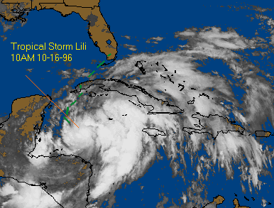
Tropical Storm Lili is gaining strength right now in the Western Caribbean, with Watches & Warnings up in Cuba and the eastern Yucatan of Mexico. It's possible that a Hurricane watch may be issued for the Florida Keys later on today. We expect the track of this storm to take it somewhere in South Florida, and perhaps clip the western end of Cuba before getting there. It's also possible that it'll go through the Florida straits and not even bug Florida with the eye of the storm. In any case, this one will probably make hurricane status, and the peninsula of Florida should be watching.
Also worthy of mention is Tropical Storm Kyle, which formed and died quickly-we were unable to update the page for about 5 days.
For more information on Lili please see the current storms page.
Other than a few tropical waves, the tropics are quiet. We will keep updated if a new storm develops.
Josephine, at noon, was still at 70MPH winds, however it still shows signs of increasing strength. By this afternoon or so it should become classified as a hurricane. Also of important note: Coastal areas in East Central Florida are now under a Tropical Storm Warning. From Cape Canaveral northward.
We are also under a Tornado Watch, and a flood watch. Hurricane Warnings exist on the west coast From just north of Tampa to the panhandle. On its current speed/heading it should reach the big bend area of Florida sometime late tonight or early tomorrow morning as a minimal hurricane.
For more information on Josephine please see the current storms page.
Josphene, at 8 AM, was a 70MPH winds, moving generally to the east, towards the west coast of Florida. Most likely, anywhere from Tampa to Tallahasse to Pensacola (Big Bend area) could be struck. 75MPH winds will cause this storm to be classified as a Hurricane, Josephene could hit Florida as a minimal hurricane. With all the wind and rain lately, the ground is already saturated, and any increase in wind could cause a lot of uprooted trees. It is important everyone on the West coast keep track of this storm (with a very good chance of it being a hurricane).
For more information on Josephine please see the current storms page.
This storm is remaining stationary right now and is forecast to stay in the same place for a while. This one could effect anywhere along the gulf so people should watch the storms progress.
For more information please see the current storms page.
After a quiet period of a couple of weeks we now have Tropical storm Isidore. This storm will have to be watched, but chances are it will not effect any land.
After a busy series of storms the Atlantic is once again quiet. None have hit Florida, but Fran was very damaging to NC, VA andother states with fooding problems.
The storm was upgraded to a hurricane this morning after hurricanehunter aircraft found the higher wind. Right now, it appears thatthis storm will cross over Hispaniola (Hati & the DominicanRepublic) after that, it's difficult to say what will happen.Stay tuned.
For more information on Hortense, please see the current storms page.
Tropical Storm Hortense has formed just east of the Leeward Islandsthis morning. It will affect the islands with minimal tropicalstorm strength (40MPH winds). After this, it is much too earlyto tell what it will do. As always, since it does have a chanceto hit somewhere in the US sometime late next week it bears watching.It is important to note that this storm is further south thanFran and Edouard was.
For more information on Hortense, please see the current storms page.
This name will be forever burned into the minds of many in NorthCarolina. This storm did a staggering amount of damage to theeast of Wilmington, NC as well as incredible flooding for therest of North Carolina, Virginia and some points north. Placessuch as Carolina Beach, Surf City, and Topsail beach were submergedunder the storm surge last night, and many places were wiped outon the barrier Islands. And this was a category 3 storm! 15 peopleare known dead because of the storm and $625 are the current estimatesand it is possible it will go up as people return to the barrierislands - which could be inaccessible for as much as a week-someof the roads have been completely washed out, and some barrierislands are still under knee-deep water. 2 million people lostpower. Many stories will surface from this, and it will be interestingto see. We wish everyone up in the area good luck and hope everyonegets back to some sense of normal soon. This was a category 3storm-it is called a major hurricane and Fran proves it. HurricaneHazel was the area's "big storm", but now I think Franhas given Hazel a run for her money.
That said, Hortense looks like it may be forming just east ofthe leeward islands in the Carribbean. It's only a Tropical Depressionnow, but it seems to be strengthening. Note that this one is furthersouth than Edouard and Fran and exactly what this means is hardto say now, but we need to watch this one very carefully.
For more information on Tropical Depression #8, please see thecurrent storms page.
Hurricane Fran is now turning to the northwest heading towardthe Carolinas. This track, as well as its current winds (115MPH-thatwill probably strengthen even moreso) make it close to a Hugo(1989) type storm. Hurricane Warnings from Brunswick, GA to CapeLookout, NC. It looks like a real problem, and we in Central Floridawish the folks there good luck and Godspeed. The watches thatwere issued for our area have been dropped.
If that weren't enough, Tropical Depression #8 has formed, asto what this will do-much too early to tell.
(We must apologize once again, as the file transferring serverswere out yesterday and we were unable to update the page.)
For more information on Fran and Depression #8, please see thecurrent storms page.
Hurricane Edouard is now barely hanging onto hurricane statusas it converts itself into a extratropical low. It barely missedthe east coast of cape Cod.
Hurricane Fran is turning out to be a real threat to Central Florida.Current tracks take it to right off the coast of West Palm Beachby Wednesday evening. However, after that it could take a jogto the north-right toward us. In any case this one will hit theUS Southeast coast, where exactly is a big question. We will probablyget watches/warnings with this one tomorrow (Tuesday) night orWednesday . It is imperative that everyone in the area keep closetabs on this storm. Even though it now has 80mph winds and isa category 1 storm it has the potential to strengthen, possiblyrapidly, before landfall. The chance of a hit on the Ft Pierceto Cocoa Beach area is already 20%, and 17% for Daytona Beach.Please keep watch. Gustav Dissipated this morning, but there isanother healthy wave out in the ocean.
For more information on both storms, please see the current storms page.
Hurricane Edouard has sped up in forward motion, making rapidweakening less likely. Long Island, NY area is still the mostlikely area land fall. However the entire watch zone needs tokeep a very close eye on the storm. Hurricane Fran was just upgradedagain and is still poses a threat to the southeast including CentralFlorida. This is because of a ridge forming north of Fran thatmost likely will cause it to move more westward over time.
For more information on all three storms, please see the current storms page.
Hurricane Edouard, a strong Cat 3 (near 4) storm is threateningto make landfall. Anywhere from NC on north may get the bruntof this storm. Long Island/New York City looks like it could bethe target, but this could change. Stay Tuned.
Fran was downgraded to a Tropical Storm, but we STILL have towatch it, it's winds are at 70MPH and it could restrengthen.
For more information on all three storms, please see the current storms page.
Looks like Edouard will head north of us, but looks as if it willhit somewhere in the mid-atlantic or northeastern states. Anyonein Georgia north, and more likely Wilmington, NC to New York Cityneeds to be careful with this one. For us, Fran, looks as if itwill mimic Edouard, which is to say, also very hard to forecast.Remember, a good rule of thumb to follow is not to count a stormout for Florida until it is NORTH of us. In any case this willspell real trouble, the hurricane has gone up to 140MPH windsagain, and could increase a little more before getting to thecolder water, and by that time, it should be ready to strike land.This could be one the whole country will remember. The Labor dayweekend timing is bad for coastal businesses as well, however,since it IS NOT forecast to hit Florida it will spell good newsfor the Cocoa Beach surf festival, since with both Fran and Edouard,the waves will be very big.
For more information on all three storms, please see the current storms page.
Busy Busy Busy. Edouard looks interesting, it appears to be regainingsome of its strength that it lost. Note, that if Edouard startsto slow down, and the trough that would push Edouard away wouldfly by before it would catch it, leaving probably more the mid-atlanticeast coast states but again FL is NOT out of the woods! (A goodrule of thumb is to not count it out until a storm is North ofFlorida). Even if it does miss us, Tropical Storm (Probably hurricaneby the time) Fran right behind it also may affect us, and longerrange, even Gustav. It is possible that Hurricane watches forthe northeastern Caribbean could go up tonight.
For more information on all three storms, please see the current storms page.
We are cautiously optimistic about Edouard's future track, itlooks like it will turn to the northwest, however it will makea more westward track before the turn. I wouldn't cancel any weekendplans yet. But keep a very close eye on the storm! Whenit does this, as in the case with Bertha, will be all important.This storm is stronger than Bertha was. Tropical Depression #7has formed near the Cape Verde Islands.
For more information on all three storms, please see the current storms page.
At 5PM on Monday it is beginning to look as if Hurricane Edouardmay be a threat to land. Either being Bermuda or the Southeastcoast of the US. However, as it is still several days away thiscould change. However, at this time, it is worth saying that Edouardhas a decent chance of becoming a factor, and if it did hit landit probably would be between a strong category three strengthto a minimal category 5 storm. Any of these would be horriblydevastating, especially with Labor Day weekend coming up. BehindEdouard is tropical depression #6 and two waves. There is no doubtthat the tropics are heating up. This depends on steering currentsfor the storm and the currents look as if it'll take more of awestward track in the future. Not good for us, the rest of thesoutheast and the Bahamas. It is good news for the Caribbean Islands.Because of high ambiguity (uncertainty) it is imperative thateveryone keeps an eye out on this storm. Also note that the internetgets swamped when major storms get near land so response timescould really slow down over the next few days. We hope to alleviatethe problem somewhat by providing alternate info source buttonson the current storms pages for advisories and certain maps.
For more information on both storms, please see the current storms page.
The best guess about this storm we here at the CFHC can give is that it'll miss the Caribbean Islands, albeit conventional wisdom states that this storm should turn away from the mainland US and head out to see, that far away is still a bit uncertain. If it stays anywhere near as strong as it is now it could be very dangerous later on. Edouard is worth watching over the next few days. Tropical Depression 6 is having a hard time developing in the wake of Edouard, but the wave behind it may very well be the 7th.
For more information on both storms, please see the current storms page.
Edouard now packing sustained winds of 140 mph and moving west-northwest at 14 mph and experts believe it will remain a major hurricane the next few days. In 3 days time it will be near the Leeward Islands and only time will tell where it will go from there. No doubt Central Florida Hurricane Chasers will continue to monitor this monster.
Dolly is no longer being tracked, but now yet another tropical depression has formed in the east Atlantic, namely Tropical Depression #6, which could be Fran by the end of the day. Hurricane Edouard is interesting in the fact that it still has the potential to be a concern for the Caribbean Islands and possibly us. This all depends on a "dent" in the high pressure keeping Edouard going west. If the dent is big enough, Edouard will slip through there and out to see. However, if it does not, than it could be trouble. Definitely one to keep an eye on.
For more information on both storms, please see the current storms page.
Eduoard has strengthened into a Hurricane, and it is worth watching still, although current forecasted tracks turn it north, it has not happened yet. Dolly is inland over Mexico and is causing floods. It should dissipate soon.
Dolly is now a Hurricane again, the pressure of this storm has been falling rapidly and it is quickly growing in strength. Edouard is still a tropical storm and still moving to the west. We will keep an eye on both.
For more information on both storms, please see the current storms page.
All of a sudden its busy in the tropics. Dolly has reformed into a tropical storm and looks like it may head toward northern Mexico perhaps as a minimal hurricane. However there is still a chance that it'll hit Texas. Edouard is still a way out in the ocean and conventional wisdom has it that this one will turn to the north and go out to sea. However, it is still worth watching. Behind Edouard is an even more impressive looking tropical wave that also has a chance of becoming another depression.
For more information on both storms, please see the current storms page.
Dolly was downgraded to a tropical depression today as it moved over land, however, now it is over warm water again and it is likely to strengthen again before the night is up. Also the fifth tropical depression of the season has formed in the eastern Atlantic ocean. This one will be several days before its even near any land mass so there is time to wait and see on this one. #5 starting coordinates: 13.0 north ... 29.5 west.
For more information on both storms, please see the current storms page.
So quickly after forming into a tropical depression, it has winds of 50Mph, and is moving west northwest. Tropical storm warnings have been extended a little more southward.
See Current Storms for more info
Tropical depression #4 has formed south of Cuba, and moving North Northwest toward the Yucatan peninsula. It has a good chance to cross the peninsula and enter the gulf, so people around the gulf coasts need to keep an eye on this storm for the next several days. At 2 PM on Monday, August 19th the storm was located at 18.7 North 83.5 West. It is likely that this storm will become Tropical Storm Dolly within 24 hours, therefore Tropical Storm Warnings have been posted for the Yucatan Peninsula of Mexico from Chetumal northward and westward to Progreso, and a watch is in effect for western Cuba and the Isle of Youth.
See Current Storms for more info
The northwest Caribbean has something worth watching. This may become the fourth tropical depression of the season, breaking weeks of non-activity. People in the NW Caribbean should keep their eyes on this one.
Cesar has moved into the pacific and may rebuild, but no longer is it a threat to the Atlantic area. Stay tuned for more Hurricane action in the Atlantic.
Hurricane Cesar is heading for Central America packing minimal hurricane winds of 80 mph. Hurricane advisories are posted for that region. See Current Storms for more info.
Tropical Storm Cesar has formed from a Tropical Depression. Currently it is a weak Tropical Storm, and strengthening is not likely tonight, however tomorrow there is a chance for it to increase in strength.
For More info on Cesar please see the Current Storms page.
Archives do not exist for stories earlier than this.
Year: [1996] [1997] [1998] [1999] [2000] [2001] [2002] [ Main Page ]
Archives for the 1995 season were not kept. The site existed on a part time basis in 1995 and was not known as CFHC until 1996. It was the active 1995 season that gave the inspiration for CFHC.