 |
||
Archived Year: [1996] [1997] [1998] [1999] [2000] [2001] [2002] [ Main Page ]
Tropical Storm Grace
16 October 1997 @ 3 PM EDT
Grace is no threat to land and the storm before her, Fabian,
was a short lived system away from land as well.
It continues to be a relatively slow Atlantic Hurricane Season.
The East Pacific, however, has been very active. Pauline did a
great deal of damage to the southeastern Mexico coastline.
[mac]
All is quiet again in the Atlantic
20 September 1997 @ 10 PM EDT
Once again, the quietness of the 1997 season is upon us.
Compared to the last two years, this is amazing-- a total
opposite.
Since Erika is gone and there seems to be no threat of anything
developing anytime soon we just haven't had anything to talk
about here.
This is good news. There is an interesting movie clip viewable of
Dr. Neil Frank's Hurricane Special that appeared on Houston TX's
local station KHOU-TV 11.
Dr. Frank was the director of the National Hurricane Center
before Dr. Bob Sheets took over. Like Dr. Sheets does from time
to time on WFTV 9 locally in Orlando, Dr. Frank does for Houston.
WFTV produced a very good TV special earlier in the summer, but
unfortunately that isn't available over the net. However Dr.
Frank's Winds of Danger can be viewed with Real Video by
clicking on this link:
Winds
of Danger from KHOU-TV and Dr. Neil Frank This requires
the Real Video player, which can be found at this site here.
Hopefully this will help trackers in the lull.
[mac]
Hurricane Linda
12 September 1997 @ 9 PM EDT
Well Hurricane Erika took a turn out to sea and spared the
Carribbean.
There is nothing going on in the Atlantic right now, but even
though we are usually stricly an Atlantic Hurricane Tracking
site, we have to mention the Strongest Eastern Pacific Hurricane
Ever, Hurricane Lina. With winds of 185MPH it may eventually
threaten California (this never happens) but as a much weaker
storm. Unfortunately data for the Eastern Pacific isn't as easily
available as for the Atlantic. So we suggest going to the Hurricane Center
for more information.
If it becomes a real threat to California we may set up a
temporary page for it.
[mac]
Hurricane Erika
5 September 1997 @ 11 AM EDT
Yes it has been upgraded to a hurricane, and it still is
moving West Northwest.
Hurricane Warnings are up for the extreme Northeast Carribbean
Islands.
Good luck to all the islanders!
See the Current
Storm Spotlight For the latest info!
[mac]
¿¿¿¿Erika????
5 September 1997 @ Midnight EDT
There is a big question with Erika.
What will she do?
She has defied most of the forecast models so far, and continues
to head generally towards the west.
She appears to be once again strengthening.
The hurricane center has put out Tropical Storm Watches for the
Carribbean Islands of Guadalupe, St. Maarten, St. Barthelemy,
Antigua, Monserrat (which also has the active and destructive
Soufriere Hills Volcano), Barbuda, Nevis, Sr. Kitts, and
Anguilla. Some of these watches probably will be upgraded to
Warnings soon.
If it makes hurricane status before it gets near these islands is
anyones guess.
But, here comes the large question, thanks to the new Gulfstream
Hurricane Hunter jet the Hurricane center has gotten a better
idea of the steering currents for Erika. And what it found is not
so good. It looks like it may not make a northerly turn, possibly
for a while, and depending on what two cold fronts do (over the
US now) in the future, it may not bode well for the US coastline,
including Florida.
However, I would still bet on this storm turning north and out to
sea before it gets to the US. But, the odds are getting closer to
50/50 now.
After all, the US is a very long way away still.
Hopefully this will change, and the storm will turn away.
Everyone should be keeping tabs on this storm for the next few
days. If it were to get near the US coastline, it would be 4 to 5
days away.
|
||
Good luck to all the islanders!
See the Current
Storm Spotlight For the latest info!
[mac]
Erika heading West
4 September 1997 @ 2:30PM EDT
Tropical Storm Erika seems to be running into shear, which
will keep it from stregthening for now, but it also has turned it
more to the west, heading for the Leeward Islands in the
Carribbean.
Nothing official has been made yet about this change in motion,
but I would bet for some Tropical Storm Watches/Warnings up
fairly soon.
What will it do to Erika in the long run is anyone's guess.
The last few satellite images of Erika have indeed shown the
storm moving almost due west towards the islands, but it seems to
be a weaker storm.
We will be awaiting the next official update on this storm with
interest.
[mac]
Tropical Storm Erika
3 September 1997 @ 5:00PM EDT
Finally, after over a month of no activity, we
have a new Tropical Storm to Track. Erika...
Where will she go? That's hard to say at this point, but I would
think it would come very close to the lesser antilles, but pass
them by to the north. However, this is definately subject to
change.
 |
||
Time to keep watch on her. Make sure to check out the Current Storm
Spotlight for the latest information about Erika.
[mac]
No Storms in August
1 September 1997 @ 4:00PM EDT
For the first time in 36 years nothing tropical
has developed in August. This is in stark contrast to the last
two years, which have had 7 in 1995 and 4 in 1996.
This is good news for everyone, but it sure makes the hobby of
tracking Atlantic storms a little dull.
It is important to note, though, that in September in the years
with no August storms it was plentiful, with several landfalling
storms. Will this be the case in 1997? That remains to be seen.
BUT! Since the storm in the western carribbean seems to have
difficulty doing anything we must look to the east... Near the
cape Verde islands is a storm that is on the verge of becoming a
depression.
Because of the attitude of this year what I just stated may well
turn out to be not true. (like the last few near-TD waves)
So Stay Tuned!
 |
||
[mac]
Tropical Depression... of the Medical kind
30 August 1997 @ 4:00PM EDT
For those of us who have the hobby of tracking tropical storms
and hurricanes in the Atlantic, it has been a very dull August,
without so much as even a depression.
It seems this is a side effect of the record strength El Nino
Southern Oscillation. Which is abnormally warm water in the
eastern pacific which tends to damped the hurricane season in the
Atlantic.
Good news is that this holiday weekend should be worry free of
storms. Well except the possible salvation of a nil month by the
system in the western carribbean which could very well become a
tropical depression in 24 hours or so. If it becomes a Tropical
Depression in August, but then becomes a storm or Hurricane in
September, it will still be officially classified as a August
storm. So there IS hope Tropical Weather Fans.
Stay tuned to that system in the western Carribbean, it has a
chance. If this does develop, landfall is almost a certainty in
the location it is at now, but we must wait and see.
[mac]
Erika Could be on the Horizon.
23 August 1997 @ 1:00AM EDT
We could very well have a 6th Tropical
Depression soon, the middle tropical wave is looking VERY
impressive.
I wouldn't be surprised to see a tropical depression later today.
Perhaps even Erika.
The wave that just emerged from Africa looks impressive too, but
its too early to tell what it will do.
 |
||
[mac]
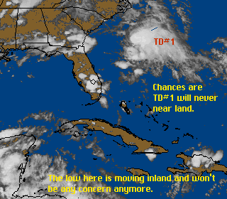
Two Areas Worth Watching
21 August 1997 @ 11:00AM EDT
The tropical wave referred to in the item below never really
got anywhere, but now we have two areas that are really worth
watching.
The Tropical wave that has just emerged from the coast of Africa
sports a circulation, which the one in the central atlantic does
not.
However, both have a decent chance of becoming something on or
before this weekend.
[mac]
It's been very quiet for weeks, but we finally
have something to watch.
16 August 1997 @ 4:00PM EDT
There is a very impressive
looking tropical wave about 850 miles to the East of the lesser
Antilles may finally break the spell of no storms to track.
Conditions are favorible for slow strengthening and it must be
watched closely over the next few days.
Right now there is no way to tell where this system will
eventually wind up.
 |
||
[mac]
Tropics calm as of now!
27 July 1997 @ 6:00PM EDT
Tropics are quiet as of now. Keep checking back
with us for the latest.
[jc]
Danny Wow! Coming back to life.
24 July 1997 @ 4:00PM EDT
Danny getting stronger over land, that's a
first. Danny has been strengthing over land and now is getting
back into water just of the coast of the North Carolina &
Virginia state lines. Danny is expected to be renamed to
"Tropical Storm Danny" again by the 5pm NHC advisory.
Danny is also forcast to get stronger in the next 12-24 hours.
Keep checking back with us for the latest.
[jc]
Danny now a Tropical Depression
20 July 1997 @ 12:00PM EDT
Tropical depression Danny now weakening. And no
longer will NHC put out any advisories. Tropical Depression #5 is
now a Tropical Wave but we will continue to watch that one for
any furthure strengthing.
[jc]
Hurricane Danny
18 July 1997 @ 12:00PM EDT
Danny was upgraded to a hurricane this morning
by the NHC, and it has already made landfall. However that was
over the Mississippi River delta, and now it is back in the gulf,
which allows it to hold its minimal hurricane strength. So it
threatens Mississippi, Alabama, and even the western panhandle of
Florida. It is moving extremely slow, so flooding from large
amounts of rain is a problem. Power, telephone, and lights are
out in quite a few places in Southeast Louisiana, and since this
is a Hurricane with a center still over water, anyone in the
Warning Area, (SE Louisiana to Destin, FL) should be done with
any precautions by now.
See the current storm spotlight for
more information.
[mac]
Danny strengthens to 60 MPH winds.
17 July 1997 @ 12:00PM EDT
This storm is quickly strengthening and could
be a hurricane very soon, people in Watch/Warning area may want
to start thinking about quick preparations at this time.
Due to sudden overload, the Current Storm Spotlight may not be
working correctly, if it is not, here is a backup.
[mac]
Tropical Depression #5 forms
17 July 1997 @ 11:30AM EDT
Beyond the news about Danny, a new tropical
depression has formed east of the winward islands that has the
potential to become a threat down the road for the islands. [mac]
Tropical Storm Danny... Forms in Gulf
17 July 1997 @ 11:00AM EDT
This is an amazing July for tracking storms.
Where in normal years, there is maybe one storm in the entire
month, we have seen four form, with at least one more (east
carribbean) looking good.
Danny is threatening land right now, it is a Tropical Storm with
50MPH winds and has the potential to strengthen pretty quickly.
It will make landfall, exactly where and how strong it will be
when it does is still up in the air. However, it looks as if it
will strike near the Lousiana coastline sometime tomorrow (7-18).
A tropical Storm Warning and a Hurricane Watch have been issued
for areas from Cameron, Lousiana to Orange Beach, Alabama. The
watch is up because it is possible that the storm could reach
minimal Hurricane force winds before it makes landfall.
If you live in this area, I'd be watching this storm VERY
closely.
More info in the Current Storm Spotlight. [mac]
Tropical Depression #4 forms in the gulf
expecting it to become Tropical Storm Danny.
16 July 1997 @ 5:00PM EDT
As of 5PM EDT Tropical
Depression #4 forms in the north Gulf. This Depression is
expected to become tropical storm Danny very soon. Also there is
another area to watch in the Carribean that also could become TD
#5 in the near future. Keep checking back with the CFHC for the
latest!
 |
||
[jc]
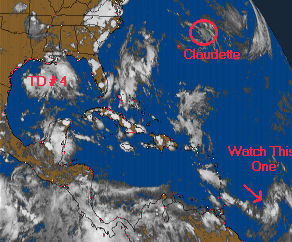
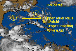
Claudette leaving. Tropics starting to fire
up!
15 July 1997 @ 10:00PM EDT
Claudette no longer showing any
growth and heading out into the Atlantic. Two upper level lows,
one off the coast of FL, and the other in the western Gulf,
starting to cause a little concern with the hurricane center. We
all need to watch these two area's very closley in the next few
days.
 |
||
[jc]
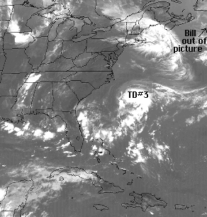
Bill out of picture, TD #3 forms, will it
become Claudette?
13 July 1997 @ 1:30PM EDT
As hurricane Bill races out of
the picture and no threat to land, Tropical Depression #3 forms
off the coast of the Carolina's. We feel this depression will
become Tropical Strom Claudette and eventually become a
hurricane. The question today is where will this storm go? Keep
checking back for the latest info.
 |
||
[jc]
Bill Upgraded to Hurricane but No Threat to
Land, and Something else Interesting to Watch!
12 July 1997 @ 5:30PM EDT
The Atlantic season begins
heating up with the first Hurricane of the year, Bill. Bill is
racing northeast away from the US and should become extratropical
fairly soon.
More interesting, possibly, is the storm that appears to be
trying to form south of Cape Hatteras. It's location and the
weather around it puts its future very much at question.
This new low brewing is definately worth keeping an eye on.
 |
||
[mac]
Tropical Storm Bill Forms Southwest of
Bermuda. Tropical Storm Warnings go up for Bermuda.
11 July 1997 @ 12:30PM EDT
The second Tropical Storm of the
1997 season has formed from that low we were watching, and is
expected it is moving AWAY from the US. However, Bermuda may be
under the gun for some Heavy Rain that is associated with a
Tropical Storm, as they have issued a Tropical Storm Warning for
that island.
 |
||
Also notable that this storm formed, officially, as a Tropical
Storm and skipped the Tropical Depression phase altogether. The
status of Bill was given by aircraft recon flights. The winds
supported it, and on the satellite picture it is starting to look
fairly decent.
See the Current Storm Spotlight for
more information on Bill.
[mac]
Is There Something Brewing East of Bahamas?
09 July 1997 @ 4PM EDT
East of the Bahama islands,
there is an area of storms where surface pressures have been
dropping recently. The conditions are ok for development and it
very well could become a depression tomorrow or Friday.
If it did, and this is important, chances are that it would veer
eventually to the northwest and then north and miss the coast of
the United States completely. However, as always, this should be
watched to see if it continues to show signs of wanting to become
a tropical depression.
 |
||
[mac]
Tropical storm Ana downgraded to tropical
depression.
03 July 1997 @ 5PM EDT
Tropical storm Ana losing strength, we believe
this storm will no longer be a threat to the coast. We will
continue to monitor the tropics, so in the mean time have a happy
4th of July weekend and stay out of the heat for prolong periods
of time.
[jc]
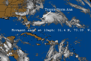
Tropical Depression #1 Upgraded to Tropical
Storm ANA.
01 July 1997 @ 5PM EDT
The first named storm of the
year, Tropical Storm Ana
TD#1 upgraded to a tropical strom Ana at 5pm est. The first day
of July and the first named storm forms in the Atlantic. Tropical
storm Ana is moving slowly east away from the US, and is unlikley
that it will threaten us. But we will keep a close eye on this
one.
Coordinates: 31.4 N, 73.39 W -- Windspeed: 45MPH - Pressure:
1002MB Movement East near 10MPH
 |
||
[jc]
The first Tropical Depression of the year
forms.
30 June 1997 @ 7PM EDT
Tropical Depression #1 has
formed east of North Carolina.
It is expected to linger and most likely go out to sea and never
threaten land. However, this is not set in stone by any means. It
is currently drifting Southeast so we are watching it.
Coordinates: 31.8 N, 75.9 W -- Windspeed: 35MPH - Pressure:
1012MB Movement East Southeast near 6MPH
 |
||
[mac]
Two Weak Lows to Watch!
29 June 1997 @ 9PM EDT
One day left for the month of
June and two weak lows are being closely watched. They may not
become anything but need to monitored. Continue to check back
with us for any further development.
[jc]
 |
||
[JC]
Is There Something Brewing East of Bahamas?
09 July 1997 @ 4PM EDT
East of the Bahama islands,
there is an area of storms where surface pressures have been
dropping recently. The conditions are ok for development and it
very well could become a depression tomorrow or Friday.
If it did, and this is important, chances are that it would veer
eventually to the northwest and then north and miss the coast of
the United States completely. However, as always, this should be
watched to see if it continues to show signs of wanting to become
a tropical depression.
|
||
[mac]
Tropical storm Ana downgraded to tropical
depression.
03 July 1997 @ 5PM EDT
Tropical storm Ana losing strength, we believe
this storm will no longer be a threat to the coast. We will
continue to monitor the tropics, so in the mean time have a happy
4th of July weekend and stay out of the heat for prolong periods
of time.
[jc]
Tropical Depression #1 Upgraded to Tropical
Storm ANA.
01 July 1997 @ 5PM EDT
The first named storm of the
year, Tropical Storm Ana
TD#1 upgraded to a tropical strom Ana at 5pm est. The first day
of July and the first named storm forms in the Atlantic. Tropical
storm Ana is moving slowly east away from the US, and is unlikley
that it will threaten us. But we will keep a close eye on this
one.
Coordinates: 31.4 N, 73.39 W -- Windspeed: 45MPH - Pressure:
1002MB Movement East near 10MPH
|
||
[jc]
The first Tropical Depression of the year
forms.
30 June 1997 @ 7PM EDT
Tropical Depression #1 has
formed east of North Carolina.
It is expected to linger and most likely go out to sea and never
threaten land. However, this is not set in stone by any means. It
is currently drifting Southeast so we are watching it.
Coordinates: 31.8 N, 75.9 W -- Windspeed: 35MPH - Pressure:
1012MB Movement East Southeast near 6MPH
|
||
[mac]
Two Weak Lows to Watch!
29 June 1997 @ 9PM EDT
One day left for the month of
June and two weak lows are being closely watched. They may not
become anything but need to monitored. Continue to check back
with us for any further development.
[jc]
|
||
[JC]
The Atlantic, Gulf and Caribbean remain quiet.
25 June 1997 @ 9AM EDT
Although the tropics are very quiet for the month of June,
Central Florida Hurricane Chasers are keeping a close eye out for
any tropical developement. Keep checking back with us to keep up
on the latest. As soon as tropical storm forms in the area we
will have a lock on it.
[jc]
Will the Remains of East Pacific Tropical Storm
Andres Redevelop?
8 June 1997 @ 8PM EDT
That is the question tonight. Pardon the lack
of updates this week.
In the Eastern pacific Tropical Storm andres formed and became
the first storm of that season, and since the CFHC is focused
only on Atlantic storms we did not cover it.
The storm wandered around and disapated over land, now however
the surface low that once was Andres has moved over the Western
Carribbean. This is something to watch, because it has a chance
to redevelop. If it does, it will be slow.
 |
||
[mac]
Disturbance off NC has moved away. The Atlantic
Tropics are quiet.
2 June 1997 @ 1PM EST
The system that was off the North Carolina coast yesterday has
merged into a cold front near Cape Cod, it is no longer a
problem.
Outside of that there is nothing going on in the Atlantic now.
The map shown yesterday was in error, the yellow arrow should
have pointed to the cloud mass just south of NC, not SE of Miami.
June is usually relatively quiet for storms and Hurricanes, the
peak of the season is in August and September. Most storms that
have formed this time of year did so in the Western Carribbean
and Gulf of Mexico. Tropical Storm Arthur, which formed near the
start of last years hurricane season, did so off the Florida
coast, which is relatively unusual for June.
The Storm
Forum is back up and working now. [mac]
Hurricane Season Begins... Small area seveal
hundred miles south of Cape Hatteras being watched.
1 June 1997 @ 8AM EST
Hurricane season is here, and we are ready for it. However,
one of our web server sites died on us last night. We have set up
two sites at two seperate locations in case the servers become
overloaded (last year during Hurricane Bertha our old web server
died due to too many people trying to get on).
This year we have two sites set up, http://www.outdoor.com/tropics
and http://digital.net/~jrc1/tropics
We prefer folks to use the outdoor.com address, as it offers more
features (like the ticker and storm forum).
As I write this, our outdoor.com server is down
if you get a DNS not found error to outdoor.com try connecting to
http://207.226.254.74/tropics.
In order to consistantly get on, even during approaching storms,
Bookmark both sites in case one is down, but try to use
outdoor.com first.
That said, we have an interesting area of weather to start off
with:
 |
||
What must be said about this area off of the south of The North
Carloina Outer Banks is that it likely will not become anything,
due to shearing from an upper level low near Tennessee that is
causing tons of rain in that area. This low is shearing off some
of the clouds off our current spotlight area.
However, if this upper low moves back then this storm may have a
chance at some organization and may become this seasons first
tropical depression. June is relatively too early for any fast
formation of a storm. This is something to watch at the very
least. [mac]
Get Prepared now for Hurricane Season.
20 May 1997
In a little over a weeks the start of Hurricane Season will
arrive. Make sure you plan ahead now for what may happen in the
future.
Part of that preperation includes planning where to go in case an
evacuation order is given for your area.
Hurricane Season Approaches. New Storm Forum is
Up!
8 May 1997
We are not finished improving the CFHC pages!
Today we have added a new suggestions/comment page to make it
easier for you to email us comments.
Also of note is the Storm Forum
which is a message board to discuss hurricanes and ask questions.
Try it out, and let people know about this site.
 |
||
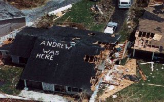
Also, this year is the 5th anniversary of Hurricane Andrew
hitting south Florida (and LA). Andrew was the costliest
Hurricane ever and reminds us what the power of these storms can
do.
Andrew could have very easily hit Central Florida, but it hit the
Homestead area and cause damage that can still be seen today.
This is NOT the type of storm we would like to see, it caused
many problems for Florida that we are still not over yet.
More Changes to the Hurricane Pages
1 May 1997
We are experimenting with new methods to use during Hurricane season, such as using a javascript program to help do the Current Storm Spotlight. We may decide to go back to the old style if this proves to be a bad decision. We have also done minor updates to the links and archives pages. There is still more to come in the future!
Also, soon the URL of this page will become http://www.outdoor.com/tropics! We will let you know when this happens! One more month till hurricane season starts again.
Hurricane Forecast Updated & Page
Redesigned
26 April 1997
Dr. William Gray and his team of hurricane researchers are sticking with their earlier prediction of 11 tropical storms, 7 of which would form into hurricanes. This predictions puts the 1997 with above-average hurricane activity. Of those, three intense storms are expected. Again, Dr. Gray's predictions do not predict land falling hurricanes, but just the amount of hurricanes in the Atlanta.
For more details see the Colorado State University report.
Hurricane Season starts June 1st.
Also of note, we have began the changes to our layout for the season. Please send us feedback if you have comments on what we are doing.
Preparing for the 1997 Hurricane Season
27 March 1997
As this year's hurricane season approaches we will attempt to be more prepared and more reliable for the coming season. In 1997 Dr. William Gray from Colorado State Univeristy has predicted an above average year for the 1997 hurricane season, see the Press Release.
1997 Hurricane Names: Ana, Bill, Claudette, Danny, Erika, Fabian, Grace, Henri, Isabel, Juan, Kate, Larry, Mindy, Nicholas, Odette, Peter, Rose, Sam, Teresa, Victor, and Wanda.
Archived Year: [1996] [1997] [1998] [1999] [2000] [2001] [2002] [ Main Page ]
Archives for the 1995 season were not kept. The site existed on a part time basis in 1995 and was not known as CFHC until 1996. It was the active 1995 season that gave the inspiration for CFHC.