Archived Year: [1996] [1997] [1998] [1999] [2000] [2001] [2002]
Jose
05:03 AM EDT - 19 October 1999
| Twenty-four Comments | Read Comments | Last 20 Comments | Newest: 11:06 AM 10-21 EDT
Irene is saying goodbye, as Jose is starting to heat up. At nearly Hurricane Status now, Jose is threatining the Leeward Islands in the Caribbean. Watches are up for these areas, and the projected track takes Jose toward the Northwest, scraping, or even crossing some of the islands.
Mainland U.S. Impact from Jose appears to be very unlikely.
For more information on Jose,
Caribbean Hurricane Page -- Personal Reports and Updates from the Caribbean Islands
NRL Monterey Tracking Site (Navy) -- Very nice forecast track graphics.
Some Forecast models:
(NGM, AVN, MRF, ECMWF, ETA)
DoD weather models (NOGAPS, AVN, MRF)
GFDL Model & Plot for Jose and for BAMB,BAMM, LBAR & A90E Models of Jose
Jose Multiple Model Forecast Composite from Michael Bryson
Weather Channel Caribbean Sat Image
Intellicast Caribbean IR Loop
Intellicast Atlantic IR Loop
More Sat images:
Storm Centered imagery.
[N.A. visible] (visible -- Daytime Only) [N.A. infrared] (infrared), and [N.A. water vapor] (water vapor)--Nasa source.
- [mac]
Tropical Storm Jose Forms. Irene Stronger than Ever..
09:43 AM EDT - 18 October 1999
| Thirty Comments | Read Comments | Last 20 Comments | Newest: 11:11 AM 10-19 EDT
Jose has formed as it is moving west toward the Caribbean islands. Soe models take it morth north toward the Leeward islands, while others keep it moving more toward the west. The best, perhaps, would be a sharp north turn and miss all the islands?
Irene never made landfall in North Carolina, and now it's stronger than it ever has been. A Category 2 storm, with conservatively 105MPH windspeed. Moving away from us, but it is somewhat interesting that its still going strong out there.
For more information on Irene and Jose,
Caribbean Hurricane Page -- Personal Reports and Updates from the Caribbean Islands
NRL Monterey Tracking Site (Navy) -- Very nice forecast track graphics.
Some Forecast models:
(NGM, AVN, MRF, ECMWF, ETA)
DoD weather models (NOGAPS, AVN, MRF)
GFDL Model & Plot for Irene and for BAMB,BAMM, LBAR & A90E Models of Irene
GFDL Model & Plot for Jose and for BAMB,BAMM, LBAR & A90E Models of Jose
Jose Multiple Model Forecast Composite from Michael Bryson
and for Irene
Weather Channel Caribbean Sat Image
Intellicast Caribbean IR Loop
Intellicast Atlantic IR Loop
More Sat images:
Storm Centered imagery.
[N.A. visible] (visible -- Daytime Only) [N.A. infrared] (infrared), and [N.A. water vapor] (water vapor)--Nasa source.
- [mac]
Tropical Depression 14 Forms East of Caribbean
06:53 PM EDT - 17 October 1999
| Ten Comments | Read Comments | Newest: 01:02 PM 10-18 EDT
Irene is moving along the coast of North Carolina heading northeast and causing more flooding problems for them.
Tropical Depression 14 has formed east of the Islands and is moving west. Projections take it into the east Caribbean. And from there you can take your pick for tracks. It may tend to head a bit more north though.
For more information on Irene and TD#14,
NRL Monterey Tracking Site (Navy) -- Very nice forecast track graphics.
Some Forecast models:
(NGM, AVN, MRF, ECMWF, ETA)
DoD weather models (NOGAPS, AVN, MRF)
GFDL Model & Plot for Irene and for BAMB,BAMM, LBAR & A90E Models Irene
GFDL Model & Plot for TD#14 and for BAMB,BAMM, LBAR & A90E Models TD#14
td14 Multiple Model Forecast Composite from Michael Bryson
Weather Channel Caribbean Sat Image
Intellicast Caribbean IR Loop
Intellicast Atlantic IR Loop
More Sat images:
Storm Centered imagery.
[N.A. visible] (visible -- Daytime Only) [N.A. infrared] (infrared), and [N.A. water vapor] (water vapor)--Nasa source.
- [mac]
Irene heading to the Carolina's, new system forming!
06:39 AM EDT - 17 October 1999
| Two Comments | Read Comments | Newest: 03:11 PM 10-17 EDT
Irene was a minimal (cat 1) hurricane, and did you see the damage it caused on Florida’s east coast? And for those of us on the east coast of Florida think they went through Hurricane Floyd. Floyd was way off shore and Florida did not go through Floyd. Just a wake up reminder of what mother nature can do.
Irene still heading north expected to make landfall somewhere in the Carolina’s. Let’s hope it makes a more easterly turn to spear North Carolina anymore flood problems.
A tropical wave located about 500 miles east of the winward islands is moving west about 10 to 15 miles. Upper level winds may become more favorable for development in the next day or two. We will have to keep an eye on this one.
For more information on Irene,
NRL Monterey Tracking Site (Navy) -- Very nice forecast track graphics.
Some Forecast models:
(NGM, AVN, MRF, ECMWF, ETA)
DoD weather models (NOGAPS, AVN, MRF)
GFDL Model & Plot for Irene and for BAMB,BAMM, LBAR & A90E Models Irene
Irene Multiple Model Forecast Composite from Michael Bryson
Weather Channel Caribbean Sat Image
Intellicast Caribbean IR Loop
Intellicast Atlantic IR Loop
More Sat images:
Storm Centered imagery.
[N.A. visible] (visible -- Daytime Only) [N.A. infrared] (infrared), and [N.A. water vapor] (water vapor)--Nasa source.
- [jc]
Eye of Irene Just East of Vero Beach
More Sat images:
Storm Centered imagery.
- [mac] Irene Makes Landfall in Southwest Florida
More Sat images:
Storm Centered imagery.
- [mac] Irene
More Sat images:
Storm Centered imagery.
- [jc] Irene moving slowly
More Sat images:
Storm Centered imagery.
- [jc] Hurricane Irene Forms South of Western Cuba
More Sat images:
Storm Centered imagery.
- [mac] Tropical Storm Irene
More Sat images:
Storm Centered imagery.
- [jc] Wind shear. End of season is near. - [jc] TD#11 No More, TD#12 Moving Slowly - [jc] The Gulf - [jc] Caribbean - [jc] Harvey Weakens not a Big Threat
More Sat images:
Storm Centered imagery.
- [jc] Tropical Storm Harvey Strengthens
More Sat images:
Storm Centered imagery.
- [jc] Tropical Storm Harvey forms in Gulf
More Sat images:
Storm Centered imagery.
- [jc] Tropical Depression Ten Forms in the Gulf of Mexico
More Sat images:
Storm Centered imagery.
- [mac] Back for Now
More Sat images:
Storm Centered imagery.
- [jc] Floyd still heading west. - [jc] Hurricane Watches From Flagler South to Hallandale -- 155MPH
More Sat images:
Floyd Centered imagery.
- [mac] More Info on Floyd
More Sat images:
Floyd Centered imagery.
- [jc] FLOYD. CAT 4. 140MPH Winds...
More Sat images:
Floyd Centered imagery.
- [mac] Strong Category 3 Hurricane Floyd Moving Towards Florida
More Sat images:
Floyd Centered imagery.
- [mac] Major Hurricane Floyd Continues to Strengthen... Tropical Storm Gert Forms in East Atlantic
More Sat images:
Floyd Centered imagery.
- [mac] Major Hurricane Floyd Heading West. Warnings and Watches up for Bahamas.
More Sat images: [N.A. visible] (visible -- Daytime Only) [N.A. infrared] (infrared), and [N.A. water vapor] (water vapor)--Nasa source. - [mac] Floyd is Days Away
More Sat images: [N.A. visible] (visible -- Daytime Only) [N.A. infrared] (infrared), and [N.A. water vapor] (water vapor)--Nasa source. - [mac] Tropical Depression #9 and Another Little Storm
More Sat images: [N.A. visible] (visible -- Daytime Only) [N.A. infrared] (infrared), and [N.A. water vapor] (water vapor)--Nasa source. - [mac] Floyd and More!
More Sat images: [N.A. visible] (visible -- Daytime Only) [N.A. infrared] (infrared), and [N.A. water vapor] (water vapor)--Nasa source. - [jc] Hurricane Floyd Forms East of the Leeward Islands
More Sat images: [N.A. visible] (visible -- Daytime Only) [N.A. infrared] (infrared), and [N.A. water vapor] (water vapor)--Nasa source. - [mac] Tropical Storm Watches for NE Leeward Islands
More Sat images: [N.A. visible] (visible -- Daytime Only) [N.A. infrared] (infrared), and [N.A. water vapor] (water vapor)--Nasa source. - [mac] Tropical Storm Floyd?
More Sat images: [N.A. visible] (visible -- Daytime Only) [N.A. infrared] (infrared), and [N.A. water vapor] (water vapor)--Nasa source. - [jc] TD#8 Forms in Central Atlantic
More Sat images: [N.A. visible] (visible -- Daytime Only) [N.A. infrared] (infrared), and [N.A. water vapor] (water vapor)--Nasa source. - [jc] TD#7 to Move into Mexico and Other Systems
More Sat images: [N.A. visible] (visible -- Daytime Only) [N.A. infrared] (infrared), and [N.A. water vapor] (water vapor)--Nasa source. - [mac] Tropical Depression Seven Forms in Bay of Campeche. Dennis Ends
More Sat images: [N.A. visible] (visible -- Daytime Only) [N.A. infrared] (infrared), and [N.A. water vapor] (water vapor)--Nasa source. - [mac] Dennis Enjoys Labor Day Weekend at the Outer Banks
More Sat images: [N.A. visible] (visible -- Daytime Only) [N.A. infrared] (infrared), and [N.A. water vapor] (water vapor)--Nasa source. - [jc] Still Dennis
More Sat images: [N.A. visible] (visible -- Daytime Only) [N.A. infrared] (infrared), and [N.A. water vapor] (water vapor)--Nasa source. - [mac] Dennis Sits. Nothing Else.
More Sat images: [N.A. visible] (visible -- Daytime Only) [N.A. infrared] (infrared), and [N.A. water vapor] (water vapor)--Nasa source. - [mac] Tropical Storm Dennis Fighting... and More
More Sat images: [N.A. visible] (visible -- Daytime Only) [N.A. infrared] (infrared), and [N.A. water vapor] (water vapor)--Nasa source. - [jc] Dennis and Wave
More Sat images: [N.A. visible] (visible -- Daytime Only) [N.A. infrared] (infrared), and [N.A. water vapor] (water vapor)--Nasa source. - [jc] Dennis moves Away from US, but is not over. TD#7 may form Today.
More Sat images: [N.A. visible] (visible -- Daytime Only) [N.A. infrared] (infrared), and [N.A. water vapor] (water vapor)--Nasa source. - [mac] Watches/Warnings Dropped for Florida Dennis has Missed
More Sat images: [N.A. visible] (visible -- Daytime Only) [N.A. infrared] (infrared), and [N.A. water vapor] (water vapor)--Nasa source. - [mac] Dennis Heading North, Gusty Winds...
More Sat images: [N.A. visible] (visible -- Daytime Only) [N.A. infrared] (infrared), and [N.A. water vapor] (water vapor)--Nasa source. - [jc] A Turn to the North May have Begun
More Sat images: [N.A. visible] (visible -- Daytime Only) [N.A. infrared] (infrared), and [N.A. water vapor] (water vapor)--Nasa source. - [mac] Tropical Storm Warning up from Sebastian to Flagler Beach
More Sat images: [N.A. visible] (visible -- Daytime Only) [N.A. infrared] (infrared), and [N.A. water vapor] (water vapor)--Nasa source. - [mac] Hurricane Watches up From Sebastian Inlet North to Fernandia Beach
More Sat images: [N.A. visible] (visible -- Daytime Only) [N.A. infrared] (infrared), and [N.A. water vapor] (water vapor)--Nasa source. - [jc] Hurricane Dennis now a Real Threat to Florida
More Sat images: [N.A. visible] (visible -- Daytime Only) [N.A. infrared] (infrared), and [N.A. water vapor] (water vapor)--Nasa source. - [mac] GFDL,BAMM,BAMD, AND DENNIS - [Mike A.] Just Move Already, Dennis...
More Sat images: [N.A. visible] (visible -- Daytime Only) [N.A. infrared] (infrared), and [N.A. water vapor] (water vapor)--Nasa source. - [mac] Dennis now a Hurricane
More Sat images: [N.A. visible] (visible -- Daytime Only) [N.A. infrared] (infrared), and [N.A. water vapor] (water vapor)--Nasa source. - [jc] Dennis the Menace and Rebirth of Cindy
More Sat images: [N.A. visible] (visible -- Daytime Only) [N.A. infrared] (infrared), and [N.A. water vapor] (water vapor)--Nasa source. - [mac] Cindy, Dennis & Emily.. (feel free to comment)
More Sat images: [N.A. visible] (visible -- Daytime Only) [N.A. infrared] (infrared), and [N.A. water vapor] (water vapor)--Nasa source. - [jc] Tropical Storm Dennis Forms East of Bahamas
More Sat images: [N.A. visible] (visible -- Daytime Only) [N.A. infrared] (infrared), and [N.A. water vapor] (water vapor)--Nasa source. - [jc] TD#5 Forms North of Puerto Rico Moving WNW
More Sat images: [N.A. visible] (visible -- Daytime Only) [N.A. infrared] (infrared), and [N.A. water vapor] (water vapor)--Nasa source. - [jc] Hurricane Bret now Inland... Weakening and The Atlantic Four
More Sat images: [N.A. visible] (visible -- Daytime Only) [N.A. infrared] (infrared), and [N.A. water vapor] (water vapor)--Nasa source. - [mac] Hurricane City (WABN) Live Internet Broadcast to Start at 3PM EDT
More Sat images: [N.A. visible] (visible -- Daytime Only) [N.A. infrared] (infrared), and [N.A. water vapor] (water vapor)--Nasa source. - [mac] Bret Heading Towards South Texas Coast
More Sat images: [N.A. visible] (visible -- Daytime Only) [N.A. infrared] (infrared), and [N.A. water vapor] (water vapor)--Nasa source. - [jc] Dangerous Hurricane Bret Still Moving North... Hurricane Cindy Forms in East Atlantic
More Sat images: [N.A. visible] (visible -- Daytime Only) [N.A. infrared] (infrared), and [N.A. water vapor] (water vapor)--Nasa source. - [jc] BRET NOW CATEGORY 4 HURRICANE 135MPH WINDS!
More Sat images: [N.A. visible] (visible -- Daytime Only) [N.A. infrared] (infrared), and [N.A. water vapor] (water vapor)--Nasa source. - [jc] Bret Now Category 3 Storm 120MPH Winds moving NORTH
More Sat images: [N.A. visible] (visible -- Daytime Only) [N.A. infrared] (infrared), and [N.A. water vapor] (water vapor)--Nasa source. - [mac] Category 2 Hurricane Bret Still Creeping Northward
More Sat images: [N.A. visible] (visible -- Daytime Only) [N.A. infrared] (infrared), and [N.A. water vapor] (water vapor)--Nasa source. - [mac] Hurricane Warnings now up for North Mexico / South Texas Coast
More Sat images: [N.A. visible] (visible) [N.A. infrared] (infrared), and [N.A. water vapor] (water vapor)--Nasa source. - [mac] Everything Else...
More Sat images: [N.A. visible] (visible) [N.A. infrared] (infrared), and [N.A. water vapor] (water vapor)--Nasa source. - [mac] Hurricane Watches up for Southern Texas Coast
More Sat images: [N.A. visible] (visible) [N.A. infrared] (infrared), and [N.A. water vapor] (water vapor)--Nasa source. - [jc] Hurricane Bret has Formed... Moving North.
More Sat images: [N.A. visible] (visible) [N.A. infrared] (infrared), and [N.A. water vapor] (water vapor)--Nasa source. - [mac] Tropical Storm Cindy Forms in East Atlantic
More Sat images: [N.A. visible] (visible) [N.A. infrared] (infrared), and [N.A. water vapor] (water vapor)--Nasa source. - [jc] Possible Hurricane Bret soon - still trending North.
More Sat images: [N.A. visible] (visible) [N.A. infrared] (infrared), and [N.A. water vapor] (water vapor)--Nasa source. - [mac] Bret Strengthening and TD#4 moving
More Sat images: [N.A. visible] (visible) [N.A. infrared] (infrared), and [N.A. water vapor] (water vapor)--Nasa source. - [mac] Tropical Storm Bret Forms in Gulf
More Sat images: [N.A. visible] (visible) [N.A. infrared] (infrared), and [N.A. water vapor] (water vapor)--Nasa source. - [jc] The Fourth Tropical Depression of the Season Forms near the Cape Verde Islands
More Sat images: [N.A. visible] (visible) [N.A. infrared] (infrared), and [N.A. water vapor] (water vapor)--Nasa source. - [jc] Third Tropical Depression of the Season Forms in Gulf
More Sat images: [N.A. visible] (visible) [N.A. infrared] (infrared), and [N.A. water vapor] (water vapor)--Nasa source. - [mac] The Other Shoe...
More Sat images: [N.A. visible] (visible) [N.A. infrared] (infrared), and [N.A. water vapor] (water vapor)--Nasa source. - [mac] Models and Yucatan
More Sat images: [N.A. visible] (visible) [N.A. infrared] (infrared), and [N.A. water vapor] (water vapor)--Nasa source. - [mac] Western Caribbean Flare-Ups - [jc] Gulf, Dora, Africa - [jc] It's About Time for some Wave Mongering - [mac] Hurricane Season is not Over - [jc] Dr. Gray Sticks to His Guns For much more detailed information please go to the source: Dr. William
Gray's Hurricane Predictions Colorado State Web site link. - [mac] Quick Summary - [jc] Except for Northeast of the Caribbean it is Quiet Again - [jc] Watching a Single System - [mac] Is Something About to Wake Up? - [mac] The Calm Before the Storms? - [jc] Tails... No Development. Another Wave Approaching the Western Caribbean - [jc] Will there be any Development? Flip a coin. - [mac] West Carribean Flare Up -- Low Level Closed Circulation - [mac] Wave Moving over Central America - [jc] System Hovering near Honduras - [mac] Eye on the Cape Verde Islands - [jc] The Southwest Gulf and New CFHC feature - [mac] No to Development - [jc] Persistence is the key... - [mac] All is Quiet - [jc] Millennium Weather - [mac] Nothing going on - [jc] Arlene is Gone. Nothing much elsewhere - [mac] The End of Arlene is Near - [jc] Arlene Approaching Bermuda... Strengthening? - [mac] Arlene Strengthening... Beating the Odds
Sat images: [N.A. visible] (visible) [N.A. infrared] (infrared), and [N.A. water vapor] (water vapor)--Nasa source. - [mac] Tropical Storm Arlene Forms
Sat images: [N.A. visible] (visible) [N.A. infrared] (infrared), and [N.A. water vapor] (water vapor)--Nasa source. - [mac] Tropical Depression #1 Forms
Sat images: [N.A. visible] (visible) [N.A. infrared] (infrared), and [N.A. water vapor] (water vapor)--Nasa source. - [mac] First Tropical Depression of the 1999 Season on the Verge of Forming - [mac] The Rain - [jc] Something Forming Off Our coast?
Sat images: [N.A. visible] (visible) [N.A. infrared] (infrared), and [N.A. water vapor] (water vapor)--Nasa source. - [mac] Wave marching West - More TV Specials - [jc] Waves off Africa - [mac] Live Broadcast on hurricanecity.com - [mac] 1999 Hurricane Season Has Begun - [mac] Updates to the page - [mac] TV Specials - [jc] "Wave Mongering" - [mac] Chances are Dropping
Sat images: [N.A. visible] (visible) [N.A. infrared] (infrared), and [N.A. water vapor] (water vapor)--Nasa source. - [jc] West Caribbean Convection
Sat images: [N.A. visible] (visible) [N.A. infrared] (infrared), and [N.A. water vapor] (water vapor)--Nasa source. - [mac] Tropical/Hybrid System Developing in Caribbean?
Sat images: [N.A. visible] (visible) [N.A. infrared] (infrared), and [N.A. water vapor] (water vapor)--Nasa source. - [mac] Use Tape on Windows or Not?
However from tests it has been found to be a waste of time, and tape.
A little masking tape is no protection against the flying debrisI in a hurricane, and the strength the tape adds is about the same as putting a piece of 1-ply tissue paper over the window.
Now after this, you will have to scrape off the baked on tape in 90 degree + weather if nothing happens. That is, if they weren't shattered in a storm. If a hurricane warning is issued its a much better idea to use shutters or 1/2" 4-ply CDX plywood. However even with this info, I doubt it'll stop people. The apparant (but totally misleading) protection that tape provides is more psychological than physically helpful.
This a good thing to know for when a real Hurricane Warning comes, you won't have too much time, so don't waste it. And just prepare earlier rather than waiting through huge, and sometimes slightly paniced and hostile lines at a local Home Improvement warehouse during an alert.
- [jc] More on the Tornadoes - [mac] Tornadoes in Oaklahoma/Kansas 26+? killed - [jc] Will the Early Season be Active? - [mac] Phase 1 of new layout in place - [mac] New Main site address www.flhurricane.com - [mac] Dr. Gray's Landfall and Storm Activity Dr. William Gray and his team at Colorodo State University
have released the April Predictions. For much more detailed information please go to the source: Dr. William
Gray's Hurricane Predictions Colorodo State Web site link. Which is quite a bit above average. Somewhat more interesting is the Landfall predictions which
are: 1999 should prove to be an interesting year for us storm
trackers. - [mac] National Hurricane Conference in Orlando I can't believe I forgot to mention this earlier, but right
now in Orlando, the National Hurricane Conference is going on.
People such as Dr. Gray and his group do speeches, Emergency
management and insurance people talk about strategies and other
things related to Hurricanes and the response to them. - [mac] Rain with Possibly Bad Storms on the Way. First, as a note, the fire talked about in the last update is
now pretty much out and no longer a problem. And it looks like we
may get some rain this weekend, with the added side effect of a
potentially wicked severe weather system moving through on
Sunday. As in high winds, hail, and tornadoes. Sunday will be the
day to watch for this as it seems the outlook for that period
suggests severe weather. This would most likely be during the
daytime Sunday. A low pressure system seems to be forming in the
gulf (Unlike the past several cold fronts) that may the front
into us with a more energized situation for severe weather. We updated the links page again, with
a few more links. Some may be "broken" in the
off-season but will return when storm season starts on June 1st. Click here for the latest Severe Warnings for
Florida - [mac] Florida Needs Rain. Wildfires 99? Yes, this is a Hurricane site, but last year the big story in
Central Florida was the fires. Massive areas, massive damage,
massive problems. And now, from my vantage point here in New
Smyrna Beach, I have watched a small bike-week campfire flare up
into what appears to be a huge fire north Of SR44 and East of
I-95. Just this morning the smoke plume has become MUCH larger.
The winds are 25+MPH blowing from the Southwest to the Northeast
(toward Sugar Mill Estates/Pioneer Trail area) . Yeserday the
Northbound side of I-95 was closed due to this fire, and today it
seems to be moving away from that and more toward the northeast. From driving by there this morning and looking at it now (from
a high vantage point on the beach looking inland) it has
definately grown in size. The wind is relentless and rather
strong. It brings back memories of last summer, which in itself
was terrible. (A relative of ours and his family lost his house
in the fire) And now because of a careless camper we may be
facing problems in the near future. Even if the fire is
controlled, the fire danger for this area is creeping back
upwards and people should be careful. I do NOT want to see a
repeat of last years activity. Best of luck to those tackling the
NSB fire in these high winds. Links for Fire Info: http://volusia.org/emergency/
Volusia County
Emergency Management Web Page - [mac] An Update To let you know that we are still alive, we are posting this
update. - [mac] 1999 Begins The first day of 1999 brings thoughts of the
1999 hurricane season to us. We will hopefully be more prepared
for what promises to be an even more active and potentially
destructive season (according to Dr. Gray's team). That said: Hurricane names for the 1999 Atlantic Hurricane
Season:Arlene, Bret, Cindy, Dennis, Emily, Floyd, Gert,
Harvey, Irene, Jose, Katrina, Lenny, Maria, Nate, Opelia,
Philippe, Rita, Stan, Tammy, Vince, Wilma. Happy New Year! - [mac] Archived Year: [1996] [1997] [1998] [1999] [2000] [2001] [2002]
07:10 AM EDT - 16 October 1999
| Twelve Comments | Read Comments | Newest: 04:29 PM 10-17 EDT
Right now Brevard County is expierencing the worst of the Storm, as the eye has just moved offshore and is now east of vero Beach moving North Northeast.
We've had some gusts of winds at our location of near 60MPH. Power is still up here however--scratch that... the UPS (battery unit) is now working.. making it quick.
Hurricane Watches have been issued for North Carolina now because of the official forecast track. Irene has the chance to strengthen again as it is now over water again.
It should be mostly over for us before the afternoon.
For more information on Irene,
NRL Monterey Tracking Site (Navy) -- Very nice forecast track graphics.
Some Forecast models:
(NGM, AVN, MRF, ECMWF, ETA)
DoD weather models (NOGAPS, AVN, MRF)
GFDL Model & Plot for Irene and for BAMB,BAMM, LBAR & A90E Models Irene
Irene Multiple Model Forecast Composite from Michael Bryson
Weather Channel Caribbean Sat Image
Intellicast Caribbean IR Loop
Intellicast Atlantic IR Loop
[N.A. visible] (visible -- Daytime Only) [N.A. infrared] (infrared), and [N.A. water vapor] (water vapor)--Nasa source.
05:00 PM EDT - 15 October 1999
| Eighteen Comments | Read Comments | Newest: 09:36 AM 10-16 EDT
Irene is causing gusts all over in southern Florida and moving toward the northeast now. The worst will be overnight tonight.
Comments are working again!
For more information on Irene,
NRL Monterey Tracking Site (Navy) -- Very nice forecast track graphics.
Some Forecast models:
(NGM, AVN, MRF, ECMWF, ETA)
DoD weather models (NOGAPS, AVN, MRF)
GFDL Model & Plot for Irene and for BAMB,BAMM, LBAR & A90E Models Irene
Irene Multiple Model Forecast Composite from Michael Bryson
Weather Channel Caribbean Sat Image
Intellicast Caribbean IR Loop
Intellicast Atlantic IR Loop
[N.A. visible] (visible -- Daytime Only) [N.A. infrared] (infrared), and [N.A. water vapor] (water vapor)--Nasa source.
07:15 AM EDT - 15 October 1999
| Two Comments | Read Comments | Newest: 08:55 AM 10-15 EDT
Hurricane watches now up for east central Florida. Irene continues to remain a cat 1 hurricane. South Florida will get a lot of rain today and some very gusty winds. Central Florida should start getting heavy rain and wind later on today and through Saturday. Hopefully Irene will not strengthen over the next 6 hours before making a landfall somewhere in southwest Florida. Watch out for tornados and flooding.
For more information on Irene,
NRL Monterey Tracking Site (Navy) -- Very nice forecast track graphics.
Some Forecast models:
(NGM, AVN, MRF, ECMWF, ETA)
DoD weather models (NOGAPS, AVN, MRF)
GFDL Model & Plot for Irene and for BAMB,BAMM, LBAR & A90E Models Irene
Irene Multiple Model Forecast Composite from Michael Bryson
Weather Channel Caribbean Sat Image
Intellicast Caribbean IR Loop
Intellicast Atlantic IR Loop
[N.A. visible] (visible -- Daytime Only) [N.A. infrared] (infrared), and [N.A. water vapor] (water vapor)--Nasa source.
10:32 PM EDT - 14 October 1999
| Four Comments | Read Comments | Newest: 07:09 AM 10-15 EDT
Irene seems to be slowing up in it's forward movment and not expected to strengthen overnight. Tracking a storm such as this with little movement is going to be a tough one. Even the experts are having a hard time with this one. Only time will tell.
Hurricane watches and warnings are up in all of south Florida.
And yes sorry for the lack of updates today we where out, but not out to dinner. SCOTTSVB or any frequent poster on this site, if your interested in posting new news articals for CFHC please email me, and I will tell you how. [John]
For more information on Irene,
NRL Monterey Tracking Site (Navy) -- Very nice forecast track graphics.
Some Forecast models:
(NGM, AVN, MRF, ECMWF, ETA)
DoD weather models (NOGAPS, AVN, MRF)
GFDL Model & Plot for Irene and for BAMB,BAMM, LBAR & A90E Models Irene
Irene Multiple Model Forecast Composite from Michael Bryson
Weather Channel Caribbean Sat Image
Intellicast Caribbean IR Loop
Intellicast Atlantic IR Loop
[N.A. visible] (visible -- Daytime Only) [N.A. infrared] (infrared), and [N.A. water vapor] (water vapor)--Nasa source.
06:17 AM EDT - 14 October 1999
| Fourty-eight Comments | Read Comments | Last 20 Comments | Newest: 10:41 PM 10-14 EDT
Although the future track is still somewhat debatable, signs indicate that it will effect us in Florida this weekend. There is already a hurricane Watch for the southern half of the Keys and for a good portion of western Cuba. We may see watches for the West Coast tomorrow.
How strong will Irene get and where will landfall be? This is open for discussion, and I'm not willing to comment yet. The storm is growing stronger now, but Cuba will impede it a bit. How much it does may be critical for us. We'll be watching.
For more information on Irene,
NRL Monterey Tracking Site (Navy) -- Very nice forecast track graphics.
Some Forecast models:
(NGM, AVN, MRF, ECMWF, ETA)
DoD weather models (NOGAPS, AVN, MRF)
GFDL Model & Plot for Irene and for BAMB,BAMM, LBAR & A90E Models Irene
Irene Multiple Model Forecast Composite from Michael Bryson
Weather Channel Caribbean Sat Image
Intellicast Caribbean IR Loop
Intellicast Atlantic IR Loop
[N.A. visible] (visible -- Daytime Only) [N.A. infrared] (infrared), and [N.A. water vapor] (water vapor)--Nasa source.
01:24 PM EDT - 13 October 1999
| Eleven Comments | Read Comments | Newest: 12:07 AM 10-14 EDT
Tropical Storm Irene forms. Could Florida be the target?
Please excuse the "Storm Spotlight" and a lot of other stuff on the site that is not working due to our cgi hosting problems. At least the COMMENT area is working. Our extensive LINKS area will help you in your reserch of Irene.
It seems you all are doing a great job in the comment (discussion) area, so keep it up. And thank you for supporting CFHC through all our troubles.
For more information on Irene,
NRL Monterey Tracking Site (Navy) -- Very nice forecast track graphics.
Some Forecast models:
(NGM, AVN, MRF, ECMWF, ETA)
DoD weather models (NOGAPS, AVN, MRF)
GFDL Model & Plot for Irene and for BAMB,BAMM, LBAR & A90E Models Irene
Irene Multiple Model Forecast Composite from Michael Bryson
Weather Channel Caribbean Sat Image
Intellicast Caribbean IR Loop
Intellicast Atlantic IR Loop
[N.A. visible] (visible -- Daytime Only) [N.A. infrared] (infrared), and [N.A. water vapor] (water vapor)--Nasa source.
08:58 AM EDT - 11 October 1999
| Nineteen Comments | Read Comments | Newest: 01:40 PM 10-13 EDT
Development if any will be slow especially in the Atlantic due to upper level winds. The only area with a hint of possible development is in the Caribbean.
I also want to apologize for the lack of updates on this site ever since Floyd; we had some serious problems with our hosting company. Our site uses some complex cgi programming and we are looking for a hosting company that can handle the load at a reasonable price. We will wait until this hurricane season is over and we will be changing over to another hosting company. Next season we will be back up and better, plan on adding a live chat area.
06:01 PM EDT - 06 October 1999
| Fourteen Comments | Read Comments | Newest: 11:48 PM 10-10 EDT
TD #11 is no longer, but the Gulf of Mexico is still brewing clouds and rain over Floirda.
TD #12 is moving slowly through the Atlantic with a WNW motion, if it remains weak a more westerly movement may begin. We will be watching this one and a few other lows in the region.
10:29 AM EDT - 04 October 1999
| Six Comments | Read Comments | Newest: 01:02 PM 10-05 EDT
Once again, we apologize for the lack of site updates. This will continue for a few more weeks, unless something threatening happens. Issues involved with the site going down during Floyd has set us back quite a bit.
Right now the system in the Bay of Campeche may want to form, but it will continue to move west. Right now there isn't much threatening at the moment. Hopefully this good luck will continue.
07:00 PM EDT - 24 September 1999
| Fifteen Comments | Read Comments | Newest: 03:37 PM 10-09 EDT
We're watching the system in the Caribbean. Sorry about the lack of updates, but it will be slow again for a period.
05:54 AM EDT - 21 September 1999
| One Comment | Read Comments | Newest: 09:21 AM 09-21 EDT
Public School has been cancelled in much of Central Florida, but it will be for naught this time, as Harvey will now move south of us and we will actually see very little in the way of heavy rainfall in Central Florida. Harvey has been invaded by dry air, which is causing the storm to weaken and head southeast instead of straight through the state as expected earlier.
For more information on Harvey see the Current Storm Spotlight for Harvey.
For more information on Gert see the Current Storm Spotlight for Gert.
NRL Monterey Tracking Site (Navy) -- Very nice forecast track graphics.
Some Forecast models:
(NGM, AVN, MRF, ECMWF, ETA)
DoD weather models (NOGAPS, AVN, MRF)
GFDL Model & Plot for Gert and for Harvey
Gert Multiple Model Forecast Composite from Michael Bryson
Harvey Multiple Model Forecast Composite from Michael Bryson
Weather Channel Caribbean Sat Image
Intellicast Caribbean IR Loop
Intellicast Atlantic IR Loop
[N.A. visible] (visible -- Daytime Only) [N.A. infrared] (infrared), and [N.A. water vapor] (water vapor)--Nasa source.
02:36 PM EDT - 20 September 1999
| Five Comments | Read Comments | Newest: 12:59 AM 09-21 EDT
It may reach minimal hurricane strength before it takes a route through Central Florida. We may actually see more effect out of this than we did Floyd. Not in the form of severe damage, but rather flooding and wind. It could be nasty tomorrow.
Tropical Storm Watches are now up for East Central Florida from Flagler to Jupiter and Warnings up from Suwanee River, FL to Bonita Beach as well (Along with Hurricane Watches). Folks along the west coast may not want to hang around on the barrier islands or anywhere you know it tends to flood. Ie, prepare for a category 1 or 2 hurricane -- it may deepen.
For more information on Harvey see the Current Storm Spotlight for Harvey.
For more information on Gert see the Current Storm Spotlight for Gert.
NRL Monterey Tracking Site (Navy) -- Very nice forecast track graphics.
Some Forecast models:
(NGM, AVN, MRF, ECMWF, ETA)
DoD weather models (NOGAPS, AVN, MRF)
GFDL Model & Plot for Gert and for Harvey
Gert Multiple Model Forecast Composite from Michael Bryson
Harvey Multiple Model Forecast Composite from Michael Bryson
Weather Channel Caribbean Sat Image
Intellicast Caribbean IR Loop
Intellicast Atlantic IR Loop
[N.A. visible] (visible -- Daytime Only) [N.A. infrared] (infrared), and [N.A. water vapor] (water vapor)--Nasa source.
06:36 AM EDT - 20 September 1999
| Five Comments | Read Comments | Newest: 02:32 PM 09-20 EDT
This should be a big rain producer for Florida, along with the threat of spawned tornadoes. Flood watches cover a large portion of the state, including Central Florida. It may get a little stronger, but I don't expect it to reach Hurricane Strength before landfall.
For more information on Harvey see the Current Storm Spotlight for Harvey.
For more information on Gert see the Current Storm Spotlight for Gert.
NRL Monterey Tracking Site (Navy) -- Very nice forecast track graphics.
Some Forecast models:
(NGM, AVN, MRF, ECMWF, ETA)
DoD weather models (NOGAPS, AVN, MRF)
GFDL Model & Plot for Gert and for Harvey
Gert Multiple Model Forecast Composite from Michael Bryson
Harvey Multiple Model Forecast Composite from Michael Bryson
Weather Channel Caribbean Sat Image
Intellicast Caribbean IR Loop
Intellicast Atlantic IR Loop
[N.A. visible] (visible -- Daytime Only) [N.A. infrared] (infrared), and [N.A. water vapor] (water vapor)--Nasa source.
10:00 AM EDT - 19 September 1999
| Fourteen Comments | Read Comments | Newest: 06:42 AM 09-20 EDT
TD#10. It should be slow to develop any further. However, the impact does rely on the intensity of the system at landfall. If it remains fairly weak, as I expect it (but you never know sometimes with Gulf Storms) Models suggest it to move slowly towards the northeast gulf, and primarily be a rain producer. Some slower than others. Yet the NOGAPS actually drifts it southwestward for a bit.
We'll be watching it. Tropical Storm Watches may be thrown up later today for some parts of the coast.
For more information on TD#10 see the Current Storm Spotlight for TD#10.
For more information on Gert see the Current Storm Spotlight for Gert.
NRL Monterey Tracking Site (Navy) -- Very nice forecast track graphics.
Some Forecast models:
(NGM, AVN, MRF, ECMWF, ETA)
DoD weather models (NOGAPS, AVN, MRF)
GFDL Model & Plot for Gert and for TD#10
Gert Multiple Model Forecast Composite from Michael Bryson
TD#10 Multiple Model Forecast Composite from Michael Bryson
Weather Channel Caribbean Sat Image
Intellicast Caribbean IR Loop
Intellicast Atlantic IR Loop
[N.A. visible] (visible -- Daytime Only) [N.A. infrared] (infrared), and [N.A. water vapor] (water vapor)--Nasa source.
12:11 PM EDT - 18 September 1999
| Eleven Comments | Read Comments | Newest: 12:20 AM 09-19 EDT
We're using a different host service to run the automated code, but this is only temporary.
We apologize for being down, but it was beyond our control.
Floyd stayed 110 miles east of our coast, and did not cause too much damage. The unprecidented evacuation (of which I was part of) was both an amazing and stressful scene. I'm sure the goverments will be learning important lessons from that. Damage was sporadic along East Central Florida, but beach erosion did happen. And of course, the unbelievable flooding in North Carolina on north will make Floyd a memorable storm for many.
Hurricane Gert is of no threat to the US, but Bermuda may have a run in with it.
There is a system in the Northwest Caribbean that's starting to cause rain here in Central Florida that some models form into a tropical depression. It will give us plenty of rain. We'll be watching that too.
For more information on Gert see the Current Storm Spotlight for Gert.
NRL Monterey Tracking Site (Navy) -- Very nice forecast track graphics.
Some Forecast models:
(NGM, AVN, MRF, ECMWF, ETA)
DoD weather models (NOGAPS, AVN, MRF)
GFDL Model & Plot for Gert
Gert Multiple Model Forecast Composite from Michael Bryson
Weather Channel Caribbean Sat Image
Intellicast Caribbean IR Loop
Intellicast Atlantic IR Loop
[N.A. visible] (visible -- Daytime Only) [N.A. infrared] (infrared), and [N.A. water vapor] (water vapor)--Nasa source.
10:56 AM EDT - 13 September 1999
| No Comments
This site is getting massive hits so please keep REFRESHING the page if all the data is not showing up or you see an internal server error.
Hurricane watches extended south through Dade county.
Where will Floyd go??? Will it turn?? When will it turn?? That is the big questions. Floyd is a very large and dangerous hurrricane with hurricane force winds extending out 100+ miles from the center of circulation and tropical force winds extend out 300 miles.
I need to go start cutting some plywood so Mike or I will be posting later on this evening when we should know a little more on what this monster is going to go.
05:01 AM EDT - 13 September 1999
| Sixteen Comments | Read Comments | Newest: 03:39 AM 09-13 EDT
Good morning. Not much new to say this morning. The storm is 1Mph shy of Category 5 status, and it's still moving West. Prepare Now. I am. Today will be sporadic post day and I'll be checking only ocassionally so hopefully all my automated stuff works without blowing up. Stay tuned to local media and keep watch.
Evacuation orders would be done tomorrow if done, so remember this. Today may be the only full day you get to have before conditions worsen. Good luck and God Bless all! It is important to not panic and just prepare smart. It could still miss us (direct landfall), but I doubt we won't get by without a fairly significant scratch from a near cat 5 Hurricane.
Weather enthusiasts who have access to a shortwave
radio may want to tune to 14.325 Mhz USB. (upper sideband)
This is the network frequency for the Hurricane Watch
Network, a Nationwide Network of Volunteer Amateur radio
Operators who provide information to the National Hurricane
Center in Florida.
This emergency information network is now active for
Hurricane Floyd.
Homepage http://www.hwn.org
For East Central Florida residents and guests looking for more information such as Evacuation Routes and Planning tips see the following pages:
[Brevard]
[Volusia] [Flagler]
[Indian River] [Inland]
[News Media]
These have links to the county sites which gives evacuation information and shelter locations.
Also our links page has links to other areas in Florida -- look for the Emergency Management County pages.
For more information on Hurricane Floyd see the Current Storm Spotlight for Hurricane Floyd.
For more information on Gert see the Current Storm Spotlight for Gert.
NRL Monterey Tracking Site (Navy) -- Very nice forecast track graphics for Floyd.
Some Forecast models:
(NGM, AVN, MRF, ECMWF, ETA)
DoD weather models (NOGAPS, AVN, MRF)
GFDL Model & Plot for Floyd and for
Gert
Multiple Model Forecast Composite from Michael Bryson
Weather Channel Caribbean Sat Image
Intellicast Caribbean IR Loop
Intellicast Atlantic IR Loop
[N.A. visible] (visible -- Daytime Only) [N.A. infrared] (infrared), and [N.A. water vapor] (water vapor)--Nasa source.
09:00 PM EDT - 12 September 1999
| Twenty Comments | Read Comments | Newest: 10:17 PM 09-12 EDT
Update 11PMLast update for tonght. No change in thinking. No watches yet, but they are expected tomorrow morning (5AM). Tomorrow will be the big decision day. Frankly, it doesn't look all that great. Some models give hope for a turn, but right now the storm is STILL moving West at 14MPH. Good night and pray for better news tomorrow.
Pressure down to 931mb
Reposted from RobertS723@aol.com with apologies in advance. Normally I don't repost but this situation will be the exception.
HURRICANE FLOYD SIGNIFICANTLY STRENGTHENED OVER THE PAST SEVERAL HOURS AND IS NOW A POWERFUL CATEGORY 4 HURRICANE CAPABLE OF CAUSING EXTENSIVE DAMAGE.
THE SYNOPTIC REASONING BEHIND THE OFFICIAL FORECAST REMAINS THE SAME AS 48 HRS AGO.....WITH AN APPROACHING TROF WHICH IS FORECAST TO PINCH OFF THE EASTERN RIDGE RESULTING IN A WEAKNESS TO FORM NORTH OF FLOYD AND TURN THE HURRICANE TOWARDS THE NORTH. HOWEVER....IT IS UNCERTAIN AS TO WHERE AND WHEN THIS NORTHWARD TURN WILL OCCUR.
THE OFFICIAL TPC FORECAST TAKES FLOYD TO THE FLORIDA EAST COAST WITHIN 72 HRS. IN RESPONSE TO THIS FACT.....THE FLORIDA STATE EOC IS AT LEVEL 2 ACTIVATION STATUS IN PREPARATION FOR A POTENTIAL CATEGORY 4 HURRICANE LANDFALL. AS OF 5:00 PM EDT THE FOLLOWING COUNTIES ARE ACTIVATED AND REPORT THE FOLLOWING:
NASSAU, DUVAL COUNTIES: EOC MONITORING PROGRESS OF FLOYD....WILL MAKE PREPARATION DECISIONS EARLY MONDAY MORNING.
ST JOHNS, FLAGLER COUNTIES: SPECIAL NEEDS EVACUATIONS ANTICIPATED MONDAY AFTERNOON.
VOLUSA COUNTY: EOC ACTIVE....SPECIAL NEEDS EVAC MAY BE REQUIRED MONDAY. FULL EVACUATION PROJECTED FOR TUESDAY.
BREVARD COUNTY: EOC ACTIVE....WILL ENTER LEVEL 2 ACTIVATION 8:00 AM MONDAY. CONFERENCE CALL SCHEDULED FOR 8:00 AM MONDAY. SPECIAL NEEDS EVAC MAY BE REQUIRED MONDAY AFTERNOON.
INDIAN RIVER COUNTY: EOC ACTIVE....ALL PREPARATION DECISIONS WILL BE MADE BY 8:00 AM MONDAY.
ST. LUCIE COUNTY: EOC ACTIVE....CONFERENCE CALL SCHEDULED FOR 8:00 AM MONDAY. SPECIAL NEEDS EVAC ANTICIPATED MONDAY AFTERNOON.
MARTIN COUNTY: EOC ACTIVE....CONFERENCE CALL SCHEDULED 8:00 AM MONDAY. DEPENDING UPON WATCHES/WARNINGS....SPECIAL NEEDS EVAC MAY BEGIN MONDAY AFTERNOON....WITH VOLUNTEER EVAC REQUIRED TUESDAY MORNING.
PALM BEACH COUNTY: EOC ACTIVE.....ALL PROTECTIVE ACTION DECISIONS WILL BE MADE BY 8:00 AM MONDAY.
BROWARD COUNTY: EOC ACTIVE....ALL DECISIONS WILL BE MADE BY 8:00 AM MONDAY. WILL GO TO LEVEL 2 STATUS NOON MONDAY.
DADE COUNTY: EOC ACTIVE....CONFERENCE CALL SCHEDULED FOR 7:00 AM MONDAY. SPECIAL NEEDS AND VOLUNTARY EVACUATIONS ANTICIPATED FOR TUESDAY.
MONROE COUNTY: EOC ACTIVE....CONFERENCE CALL SCHEDULED FOR 8:00 AM MONDAY....WILL MAKE PREPARATION DECISIONS EARLY MONDAY MORNING.
**** ALL INTERESTS ALONG THE EAST COAST SHOULD CONTINUE TO MONITOR THE PROGRESS OFHURRICANE FLOYD. FOLLOW ALL RECOMMENDATIONS FROM LOCAL AUTHORITIES. BELOW ARE SOME TIPS ON HOW TO PREPARE FOR A HURRICANE:
Preparation for a Power Outage - - Check the working condition of flashlights, batteries and battery-powered radios. Should power go out in your area, a working battery-powered radio may be your only way to get outside information. Also, in the event of a power failure, flashlights may be your only source of light.
NOAA Weather Radio - - Make sure the radio you buy is both electric and battery powered in case you lose electricity.
Adequate Supply of Food and Water - - Make sure you have enough non-perishable food and water on hand for one to two weeks. In the event of a catastrophic storm, you could be without power for at least that long. It is recommended that you have one gallon of water per person, per day.
Supplies to Protect Your Home - - Buy and store materials, such as plywood and plastic, to secure your home in the event of a storm.
Inspection of Your Home�s Exterior - - Check the area around your home for potential problems. Make sure rain gutters and spouts are secure and not clogged. Inspect the roof for loose tiles, shingles, or debris. Keep trees and shrubbery well trimmed and remove any dead or dying branches. Make sure any loose items, such as garbage cans, lawn furniture, or plants, are taken inside or tied down.
Making Plans for Your Boat - - If you own a boat, make sure you know where you will move it in the event of an approaching storm.
Securing Important Documents - - Gather insurance policies and other important documents and store in a safe, dry place. It is also recommended that you inventory your property, on video tape if possible, and store it with these documents. You may also want to send copies to a relative out of the area.
Having Quick Access to Emergency Numbers - - Post emergency telephone numbers near your phone. Remember, do not call 911 unless you have a real emergency. Also, teach children how to make long-distance phone calls and how and when to call 911.
Preparation for Possible Evacuation - - Anyone who lives in a coastal storm surge area, in low-lying flood-prone areas or in a mobile home should be prepared to evacuate if instructed to do so by local officials. If you are in an area that is likely to be evacuated, contact friends or family members who live inland and make plans to stay with them. Know the evacuation routes, plan to leave with plenty of time to get to a safe place, and review
these plans with your family. You should also know where public shelters are located in your area. Public shelters do not allow pets, so make alternate arrangements if necessary. In addition, anyone who is at risk for medical reasons could be forced to evacuate. At-risk people should register now with their county emergency management office.
Weather enthusiasts who have access to a shortwave
radio may want to tune to 14.325 Mhz USB. (upper sideband)
This is the network frequency for the Hurricane Watch
Network, a Nationwide Network of Volunteer Amateur radio
Operators who provide information to the National Hurricane
Center in Florida.
This emergency information network is now active for
Hurricane Floyd.
Homepage http://www.hwn.org
For East Central Florida residents and guests looking for more information such as Evacuation Routes and Planning tips see the following pages:
[Brevard]
[Volusia] [Flagler]
[Indian River] [Inland]
[News Media]
These have links to the county sites which gives evacuation information and shelter locations.
Also our links page has links to other areas in Florida -- look for the Emergency Management County pages.
For more information on Hurricane Floyd see the Current Storm Spotlight for Hurricane Floyd.
For more information on Gert see the Current Storm Spotlight for Gert.
NRL Monterey Tracking Site (Navy) -- Very nice forecast track graphics for Floyd.
Some Forecast models:
(NGM, AVN, MRF, ECMWF, ETA)
DoD weather models (NOGAPS, AVN, MRF)
GFDL Model & Plot for Floyd and for
Gert
Multiple Model Forecast Composite from Michael Bryson
Weather Channel Caribbean Sat Image
Intellicast Caribbean IR Loop
Intellicast Atlantic IR Loop
[N.A. visible] (visible -- Daytime Only) [N.A. infrared] (infrared), and [N.A. water vapor] (water vapor)--Nasa source.
06:04 PM EDT - 12 September 1999
| Fifteen Comments | Read Comments | Newest: 03:53 PM 09-12 EDT
Update 8:30PMModels are still have various solutions, but sometimes hurricanes this strong create their own environments. Some models tend to pull it north before landfall, but not before getting too close to Florida for comfort (effects will be felt). Others still insist on landfall. Tomorrow should be decision and prep day for folks along Florida. It will be for us. Get a good nights rest and check up on it tomorrow. Perhaps prayers will be answered and one of the more extreme to the right scenarios will hold out.
Update 8:00PMWinds now at 145Mph. We'll be updating once again at 11PM and then calling it a night. It will have to get to 156mph to become a Category 5. Pray that does not happen. The scenarios setting up could be long lasting.
Old:
Need I say more...
From the "Tropical Storm Special Update" above the posts:
TCUAT
BULLETIN
HURRICANE FLOYD TROPICAL CYCLONE UPDATE
NATIONAL WEATHER SERVICE MIAMI FL
6 PM AST SUN SEP 12 1999
LATEST REPORTS FROM AN AIR FORCE RESERVE HURRICANE HUNTER AIRCRAFT
SHOW THAT THE MAXIMUM SUSTAINED WINDS IN HURRICANE FLOYD HAVE
INCREASED TO 140 MPH. THIS MAKES FLOYD
A CATEGORY FOUR HURRICANE ON
THE SAFFIR/SIMPSON HURRICANE SCALE. THE HURRICANE HUNTERS ALSO
MEASURED A MINIMUM CENTRAL PRESSURE OF 935
MB...27.61 INCHES.
AN INTERMEDIATE ADVISORY WILL BE ISSUED 8 PM AST.
PASCH
For East Central Florida residents and guests looking for more information such as Evacuation Routes and Planning tips see the following pages:
[Brevard]
[Volusia] [Flagler]
[Indian River] [Inland]
[News Media]
These have links to the county sites which gives evacuation information and shelter locations.
Also our links page has links to other areas in Florida -- look for the Emergency Management County pages.
For more information on Hurricane Floyd see the Current Storm Spotlight for Hurricane Floyd.
For more information on Gert see the Current Storm Spotlight for Gert.
NRL Monterey Tracking Site (Navy) -- Very nice forecast track graphics for Floyd.
Some Forecast models:
(NGM, AVN, MRF, ECMWF, ETA)
DoD weather models (NOGAPS, AVN, MRF)
GFDL Model & Plot for Floyd and for
Gert
Multiple Model Forecast Composite from Michael Bryson
Weather Channel Caribbean Sat Image
Intellicast Caribbean IR Loop
Intellicast Atlantic IR Loop
[N.A. visible] (visible -- Daytime Only) [N.A. infrared] (infrared), and [N.A. water vapor] (water vapor)--Nasa source.
04:50 PM EDT - 12 September 1999
| Two Comments | Read Comments | Newest: 10:58 AM 09-12 EDT
Mini Update 6:00PM: The 12Z GFDL model turns Floyd to the right much sooner than previous runs and may be some hope for us. Tomorrow will be decision day for many.
Mini Update 5:20PM: There is a good chance we will see a hurricane watch up for areas in Florida later tonight (11PM advisory) or early tomorrow morning.
Prepare to Prepare.
Floyd has the potential to make a killer run up the east coast with a start in our area in Florida. Timeframe is for the closest approach Tuesday Night. There is still a great deal of uncertainty in the future track. Note the increase in Forward speed from 12 to 14Mph. Not good.
Models continue to suggest a near landfall in Central Florida. A slight jog to the west would be enough for a full landfall. Either way there is enough to cause major problems here. Especially as strong category 3 storm (forecasted to 4). I'm beginning preps myself tomorrow and Tuesday. So these will most likely be a sporadic post day. I'd rather be prepared even if it curves.
I don't want to be an alarmist, but I also don't want to understate the trouble a category 4 hurricane can cause on populated coastal areas.
Also, Gert is almost a hurricane and moving west. We'll have time to watch it later.
For East Central Florida residents and guests looking for more information such as Evacuation Routes and Planning tips see the following pages:
[Brevard]
[Volusia] [Flagler]
[Indian River] [Inland]
[News Media]
These have links to the county sites which gives evacuation information and shelter locations.
Also our links page has links to other areas in Florida -- look for the Emergency Management County pages.
For more information on Hurricane Floyd see the Current Storm Spotlight for Hurricane Floyd.
For more information on Gert see the Current Storm Spotlight for Gert.
NRL Monterey Tracking Site (Navy) -- Very nice forecast track graphics for Floyd.
Some Forecast models:
(NGM, AVN, MRF, ECMWF, ETA)
DoD weather models (NOGAPS, AVN, MRF)
GFDL Model & Plot for Floyd and for
Gert
Multiple Model Forecast Composite from Michael Bryson
Weather Channel Caribbean Sat Image
Intellicast Caribbean IR Loop
Intellicast Atlantic IR Loop
[N.A. visible] (visible -- Daytime Only) [N.A. infrared] (infrared), and [N.A. water vapor] (water vapor)--Nasa source.
10:57 AM EDT - 12 September 1999
| Fourteen Comments | Read Comments | Newest: 10:20 AM 09-12 EDT
NEW Intensity Update 4:30PM: Pressure has dropped to 940mb. Expect the windspeed to go up. More soon.
Intensity Update 3:00PM: Aircraft Recon have determined the central pressure in Floyd to be 944mb, which is a drop of 11mb since this morning. This is fairly significant and means that we may be seeing a category 4 hurricane tonight. Prepare to Prepare.
Mini Update 12:30PM: It looks like watches will be issued for parts of Florida Tomorrow. Timeframe for Floyd approach is late Tuesday Early Wednesday morning currently. The Current NHC Forecast track does not make landfall on Florida, yet. But it does place it close enough to Cape Canaveral for the effect of 100+ Mph winds to be felt along the coastline. Please keep this in mind as you prepare to prepare. If you notice on the satellite pictures, Floyd is elongated in the east/west direction. This is not a good sign for Florida. Keep watch.
Tropical Storm Gert has now formed in the East Atlantic and will track West over the next several days. There is a bit of time to watch this one as the main concern is somewhat closer.
Floyd is now up to 120MPH sustained windspeed around the eye, and looks good on satellite photos. It's still moving west at the moment, which raises the question... Will it effect Florida?
The discussion from earlier today hasn't changed, yet. But I must emphasize (again) that we should be prepared to get prepared if Watches/Warnings are issued for Florida. It is important to note that the new 72hour forecast position from the NHC places the center of Floyd less than 50 miles offshore from Cape Canaveral. It's going to be too close again.
Floyd is larger than Dennis. Remember this.
As always, feel free to comment, agree, disagree, ask questions, or post your own interpretation.
For East Central Florida residents and guests looking for more information such as Evacuation Routes and Planning tips see the following pages:
[Brevard]
[Volusia] [Flagler]
[Indian River] [Inland]
[News Media]
These have links to the county sites which gives evacuation information and shelter locations.
Also our links page has links to other areas in Florida -- look for the Emergency Management County pages.
For more information on Hurricane Floyd see the Current Storm Spotlight for Hurricane Floyd.
For more information on Gert see the Current Storm Spotlight for Gert.
NRL Monterey Tracking Site (Navy) -- Very nice forecast track graphics for Floyd.
Some Forecast models:
(NGM, AVN, MRF, ECMWF, ETA)
DoD weather models (NOGAPS, AVN, MRF)
GFDL Model & Plot for Floyd and for
Gert
Multiple Model Forecast Composite from Michael Bryson
Weather Channel Caribbean Sat Image
Intellicast Caribbean IR Loop
Intellicast Atlantic IR Loop
[N.A. visible] (visible -- Daytime Only) [N.A. infrared] (infrared), and [N.A. water vapor] (water vapor)--Nasa source.
08:54 AM EDT - 12 September 1999
| Three Comments | Read Comments | Newest: 03:42 AM 09-12 EDT
Florida should be paying attention to this storm and beginning to think what would it do if it were to hit.
However--cautiously optimistic--, I still don't see *direct landfall* in Florida happening. It may come close enough and has a decent enough chance to move more west to feel hurricane force winds (unlike Dennis) which does warrant full preperations. Assume it will, I'd imagine.
Why? Well the long range models (With the notable exception of the MRF--Which is indeed a reason to worry) and climatology support no landfall, and I'm always cautiously optimistic. Make no mistake I would very much like to see no hurricanes hit Florida. Also make no mistake that I'm not a meterologist. But there is no need for voodoo meterology when it comes to a storm like this. Bottom line, be prepared to prepare, do the small things now (gas, etc.) and pray for the best. If watches/warnings due occur for Florida, then follow instructions given by officials.
I must emphasize, this one is going to be even closer than Dennis. And that means landfall--Anywhere in East Florida--is still a possibilty. But hype can be dangerous too, and that's why I'm cautiously optimistic. If you want hype you won't find it here. You will find common sense. Florida is looking down the barrel of a gun at Floyd. It is a major hurricane, and you should treat it with the proper preperations as I do. If my thinking changes I will post so on this site as soon as I can.
By the Way, did I mention the fact that Floyd is now a major hurricane and everyone in the east coast should watch it and make preperations and watch official sources for info as it gets closer. If I was too redundant in the above post then I did my job.
As always, feel free to comment, agree, disagree, ask questions, or post your own interpretation.
For more information on Hurricane Floyd see the Current Storm Spotlight for Hurricane Floyd.
For more information on TD#9 see the Current Storm Spotlight for TD#9.
NRL Monterey Tracking Site (Navy) -- Very nice forecast track graphics for Floyd.
Some Forecast models:
(NGM, AVN, MRF, ECMWF, ETA)
DoD weather models (NOGAPS, AVN, MRF)
GFDL Model & Plot for Floyd and for
TD#9
Multiple Model Forecast Composite from Michael Bryson
Weather Channel Caribbean Sat Image
Intellicast Caribbean IR Loop
Intellicast Atlantic IR Loop
07:05 PM EDT - 11 September 1999
| Twenty-five Comments | Read Comments | Last 20 Comments | Newest: 02:11 AM 09-12 EDT
Sometimes people forget that even when talking about storms that something is days away. Floyd itself is (on current thinking) not going to affect the US until Mid Week (Tue-Wed). This gives the forecast lots of time to change, and I think--right now--that it will not directly landfall in Florida.
I'm resting heavily on climatology here in my thinking, with only one model suggesting landfall in Florida (AVN/MRF) I can't really go with that solution now. However, as the new week begins we will have time to track and watch the storm. The NHC official forecast suggest it will come close to Florida--closer than Dennis. This does NOT mean Florida is all clear, quite the contrary. Since there are always exceptions to climatology (Andrew (1992)/ 1935 Labor Day Keys Storm). Everyone along the southeast US coast and Bahamas will need to keep tabs on the storm for a while, and watch the model trends.
The key here will be if these models trend to the west, Florida landfall is more likely, otherwise it could be elsewhere. But since its mid-week we have the weekend to enjoy and ponder where it may go. Floyd is bigger (in both windspeed and size) than Dennis and has more potential to cause havoc. If you disagree or have your own thoughts or questions feel free to comment.
Since some have been comparing Floyd to Andrew (as far as track--note that I don't agree), here is an old satellite loop animation of Andrew.
TD#9 may become Gert later tonight or tomorrow, and the system in the Central Atlantic may form into something, but it will take time if it does at all.
The server debugging session never happened today, but we did alter the code of the site a bit to lessen the chance of an overload-related blackout.
For more information on Hurricane Floyd see the Current Storm Spotlight for Hurricane Floyd.
For more information on TD#9 see the Current Storm Spotlight for TD#9.
NRL Monterey Tracking Site (Navy) -- Very nice forecast track graphics for Floyd.
Some Forecast models:
(NGM, AVN, MRF, ECMWF, ETA)
DoD weather models (NOGAPS, AVN, MRF)
GFDL Model & Plot for Floyd and for
TD#9
Multiple Model Forecast Composite from Michael Bryson
Weather Channel Caribbean Sat Image
Intellicast Caribbean IR Loop
Intellicast Atlantic IR Loop
12:20 PM EDT - 11 September 1999
| Eleven Comments | Read Comments | Newest: 11:00 AM 09-11 EDT
The busy weeks for us continue, and I've finally managed to get a chance to write a new update. We're suffering from sporadic downtimes as well. Today I will try to isolate where the problem is coming from. I may redirect the site to our local system in an attempt to track the crash bug down. (Ie the site will be slow temporarily while boundschecker is running off a dialup)
Tropical Depression #9 has formed in the Atlantic, and we will have time to monitor it later.
There is also the matter of the other storm, Floyd. Which, by all indications, is going to be trouble. Why? Well it's growing in strength and the track puts it close to Florida. Models take it in various directions. It's expected to move more toward the west later, but the GFDL now trends it toward the Carolinas, while the MRF model takes it into south Florida. As a major hurricane, this one will be yet another storm to watch like a hawk over the next few days. The Bahamas may have to deal with it also. But by no means is the track a sure thing.
We'll be adding things here and there throughout today, so keep an eye out.
For more information on Hurricane Floyd see the Current Storm Spotlight for Hurricane Floyd.
For more information on TD#9 see the Current Storm Spotlight for TD#9.
Some Forecast models:
(NGM, AVN, MRF, ECMWF, ETA)
DoD weather models (NOGAPS, AVN, MRF)
GFDL Model & Plot
Weather Channel Caribbean Sat Image
Intellicast Caribbean IR Loop
Intellicast Atlantic IR Loop
12:55 PM EDT - 10 September 1999
| Twenty-six Comments | Read Comments | Last 20 Comments | Newest: 09:25 AM 09-11 EDT
It's getting busy again. Hurricane Floyd appears to be slowly winding up, and east of Floyd there are two interesting areas that may develop in the next few days.
Models are trending more to the west again. One interesting item is that the MRF gives it a track similar to Hurricane David (1979) in the long range. But that would be for "entertainment purposes only" as the MRF (some call it the Most random forecast) can be way off on tropical systems sometimes. The GFDL still has it turning more back to the west as it approached the Bahamas, and the NOGAPS still has it going out to sea. Ie, roll the dice or throw a dart.
We'll be watching it. Good news is that it does look it will miss the Caribbean islands.
Personal Reports from the Caribbean -- Caribbean Hurricane Page
For more information on Hurricane Floyd see the Current Storm Spotlight for Hurricane Floyd.
Some Forecast models:
(NGM, AVN, MRF, ECMWF, ETA)
DoD weather models (NOGAPS, AVN, MRF)
GFDL Model & Plot
Weather Channel Caribbean Sat Image
Intellicast Caribbean IR Loop
Intellicast Atlantic IR Loop
07:22 AM EDT - 10 September 1999
| Two Comments | Read Comments | Newest: 06:09 AM 09-10 EDT
Interesting changes have been happening since yesterday. It appears the chances for a US landfall are going up, but it is still not certain. People from here in Florida up to southern New England will have to watch this storm as it moves westward. A threat to Florida is still somewhat unlikely, but it will become more clear in about 3 days or so.
Once again it depends on a weather trough moving out and a ridge taking its place. Some models (GFDL) move it dramatically westward, while others (NOGAPS) Keep it off the coast, but move it closer to New England. Indeed some people have noted a similar setup to some of the big storms that have hit the Northeast US. But that seems to be mostly speculation at this point. The Leeward islands will get clipped, but I don't think they will deal with the eyewall effects. For intensity, I think we'll see a major hurricane out of Floyd. At least a mid-range category 3. If landfall occurs it won't be until 4-5 days from now (assuming it does not stall). Once again, the entire southeast coast, from Florida all the way up to New England should be watching this one.
Personal Reports from the Caribbean -- Caribbean Hurricane Page
For more information on Hurricane Floyd see the Current Storm Spotlight for Hurricane Floyd.
Some Forecast models:
(NGM, AVN, MRF, ECMWF, ETA)
DoD weather models (NOGAPS, AVN, MRF)
GFDL Model & Plot
Weather Channel Caribbean Sat Image
Intellicast Caribbean IR Loop
Intellicast Atlantic IR Loop
05:10 PM EDT - 09 September 1999
| Seven Comments | Read Comments | Newest: 06:08 PM 09-09 EDT
Tropical Storm Floyd (on the verge of hurricane status), is now moving West North West and approching the islands. The storm may clip the islands and then continue on toward the WNW and eventually turn further north. Question is when (been here before, eh). We'll be watching this like a hawk and welcome any opinions on the intensity and future path of the storm.
Personal Reports from the Caribbean -- Caribbean Hurricane Page
For more information on TS Floyd see the Current Storm Spotlight for TS Floyd.
Some Forecast models:
(NGM, AVN, MRF, ECMWF, ETA)
DoD weather models (NOGAPS, AVN, MRF)
GFDL Model & Plot
Weather Channel Caribbean Sat Image
Intellicast Caribbean IR Loop
Intellicast Atlantic IR Loop
01:24 PM EDT - 08 September 1999
| Seventeen Comments | Read Comments | Newest: 09:13 AM 09-09 EDT
Now that we are reaching the peak of hurricane season (Sept. 10), the tropics are starting to fire up again. Tropical Storm Floyd is forecasted by the National Hurricane Center to go slightly north of the Leeward Islands and continue on its WNW track strengthening to a hurricane within 32 hours.
Lets hear the comments on where you might think Floyd will go..
Two other waves coming off the Africa coast bare watching.
Personal Reports from the Caribbean
For more information on TS Floyd see the Current Storm Spotlight for TS Floyd.
Some Forecast models:
(NGM, AVN, MRF, ECMWF, ETA)
DoD weather models (NOGAPS, AVN, MRF)
Weather Channel Caribbean Sat Image
Intellicast Caribbean IR Loop
Intellicast Atlantic IR Loop
08:02 PM EDT - 07 September 1999
| Five Comments | Read Comments | Newest: 04:31 AM 09-08 EDT
TD#7 moved inland, and as expected, we have a new depression in the Central Atlantic.
This depression is in a favorable environment for development and may once again move close to the US coast. Threat to Florida is minimal according to models right now, but that could change as it is quite a distance from the US currently and long range models are about worthless at this range. The islands may have to deal with it but this is up in the air also. Plenty of room for discussion. The depression is expected to strengthen at a fairly slow, but steady clip.
For more information on TD#8 see the Current Storm Spotlight for TD#8.
Some Forecast models:
(NGM, AVN, MRF, ECMWF, ETA)
DoD weather models (NOGAPS, AVN, MRF)
Weather Channel Caribbean Sat Image
Intellicast Caribbean IR Loop
Intellicast Atlantic IR Loop
09:02 AM EDT - 06 September 1999
| Thirty Comments | Read Comments | Last 20 Comments | Newest: 04:02 PM 09-07 EDT
Quick note, what's left of Dennis is still dumping rain over North Carolina. I once lived in Raleigh, so I can imagine how that amount of rain can flood certain areas.
TD#7 is NOT acting like Bret, and is much closer to the Mexican coast that Bret was. It most likely will go fully inland (it's almost at that point now) later today over Mexico without strengthening all that much.
In the rest of the Atlantic, there is a wave in the Central Atlantic that still bears watching, and a smaller wave near to the Lesser Antilles that also has flared up this morning.
We will be watching.
For more information on TD#7 see the Current Storm Spotlight for TD#7.
Some Forecast models:
(NGM, AVN, MRF, ECMWF, ETA)
DoD weather models (NOGAPS, AVN, MRF)
Weather Channel Caribbean Sat Image
Intellicast Caribbean IR Loop
Intellicast Atlantic IR Loop
05:06 PM EDT - 05 September 1999
| Three Comments | Read Comments | Newest: 06:32 PM 09-05 EDT
Well, no sooner than the last official advisory on Dennis was written, we have a new tropical depression to speak of, with the prospect of another later this week in the Central Atlantic. Dennis is now just dumping rain over North and South Carolina, and probably causing some flooding problems. Dennis is no longer being tracked by the NHC.
TD#7 however, may want to immitate Hurricane Bret, which is not good for Texas. The NHC hints it may want to travel further north like Bret did, so once again, we'll be watching. The official forecast is to have it make landfall in Northern Mexico before getting too strong. It's a bit early to form any serious conclusions on it, however.
I apologize for the lack of the "Local Hurricane Statements" for North Carolina, but lack of time last week as well as other technical problems kept it from happening.
For more information on TD#7 see the Current Storm Spotlight for TD#7.
Some Forecast models:
(NGM, AVN, MRF, ECMWF, ETA)
DoD weather models (NOGAPS, AVN, MRF)
Weather Channel Caribbean Sat Image
Intellicast Caribbean IR Loop
Intellicast Atlantic IR Loop
07:41 AM EDT - 04 September 1999
| Five Comments | Read Comments | Newest: 08:08 AM 09-05 EDT
Unfortunately the same can't be said for everyone else there. Barring any last minute surprises, Dennis is now making his move to landfall in Eastern North Carolina. From there, it will most likely shoot up the Northeastern States all the way to Maine, while inland. Causing some rain for areas that need it. If anything good can be said of Dennis, this is it. Unfortunately it won't be a drought-ender for those places, but it will help.
Elsewhere, other than a wave that just came off Africa, there isn't much to talk about right now. Some models hint at another round of development later, but for now it is mostly quiet.
For more information on Dennis see the Current Storm Spotlight for Dennis.
Some Forecast models:
(NGM, AVN, MRF, ECMWF, ETA)
DoD weather models (NOGAPS, AVN, MRF)
Weather Channel Caribbean Sat Image
Intellicast Caribbean IR Loop
Intellicast Atlantic IR Loop
07:43 AM EDT - 03 September 1999
| Seven Comments | Read Comments | Newest: 05:12 PM 09-03 EDT
Other than the fact Dennis moved a bit to the south, nothing has changed with Dennis
There isn't anything else worth watching either.
Unfortunately for our friends in the NC outer banks, it won't be a nice labor day weekend.
For more information on Dennis see the Current Storm Spotlight for Dennis.
Some Forecast models:
(NGM, AVN, MRF, ECMWF, ETA)
DoD weather models (NOGAPS, AVN, MRF)
Weather Channel Caribbean Sat Image
Intellicast Caribbean IR Loop
Intellicast Atlantic IR Loop
06:28 AM EDT - 02 September 1999
| Four Comments | Read Comments | Newest: 04:36 PM 09-02 EDT
Today we see Dennis just where it was yesterday.
It has not moved, and looks like it may continue to do so. Interestingly enough Dennis looks more like an extratropical Nor'easter now than a tropical storm. But even then it does still have little hints of its tropical nature. There is just nothing new to say on it.
The area in the Southeast Gulf is gone, and there isn't much else to mention in the Atlantic moment. So we may get a break. However we still have not reached the climatological peak (Sept 15) so it's definitely not over.
For more information on Dennis see the Current Storm Spotlight for Dennis.
Some Forecast models:
(NGM, AVN, MRF, ECMWF, ETA)
DoD weather models (NOGAPS, AVN, MRF)
Weather Channel Caribbean Sat Image
Intellicast Caribbean IR Loop
Intellicast Atlantic IR Loop
06:14 AM EDT - 01 September 1999
| Five Comments | Read Comments | Newest: 10:44 AM 09-01 EDT
Dennis was downgraded to a Tropical Storm overnight due to the fact it has hardly any convection around it, and the fact that it is almost a hybrid extratropical storm right now. It's in a very odd state because it's on the margins for both, and could reform into a Hurricane if it works down south more. Convection around the eye is not there, but it consistantly tries to form something on the north eye and the temperatures in the core are slightly warmer than the rest, so Dennis can not be declassified as Tropical System yet. It may teeter on this hybrid state for a while, and depending on where it meanders could reintensify. That will take a while, but Dennis seems to want to take a while. Models are all over the place, but tend to agree with a general slow West and West Southwest motion. A more southerly direction would cause it to go against the Gulf Stream, which would mean more warm water for it as it would be replinished faster.
It's hybrid ness is causing the windfield to expand as well, which makes being on the outer banks this week not so nice. It'll be around in one form or another through the weekend. The models that predict a more southerly motion bring it in towards the SC coast, and before anyone asks, returning to Florida looks extremely unlikely.
Otherwise, Cindy is now extratropical and going away. Two waves worth talking about. One in the Southeast Gulf of Mexico that may or may not do something in a few days, and the wave that we talked about yesterday, which is looking bad this morning. It probably won't even form now.
So currently, Dennis lingers around to be the only story at the moment.
For more information on Dennis see the Current Storm Spotlight for Dennis.
Some Forecast models:
(NGM, AVN, MRF, ECMWF, ETA)
DoD weather models (NOGAPS, AVN, MRF)
Weather Channel Caribbean Sat Image
Intellicast Caribbean IR Loop
Intellicast Atlantic IR Loop
05:36 AM EDT - 31 August 1999
| Twelve Comments | Read Comments | Newest: 03:22 PM 09-01 EDT
Dennis remains offshore of North Carolina and is slowing down as predicted. What happens next is a wait. It will sit and spin off the coast for a bit before making its move. Which could be out to see, closer to the NE coastline, or back towards North Carolina. It's been even more of a pain because there is a high pressure system to the north of it that is creating a gradient that has much enlarged the tropical storm force windfield. Making it ugly along the NC and Virginia coasts. Future track is really anyone's guess, and it may be weaker when it does, but that's not certain either.
Cindy is moving fast and away as a Tropical Storm and is almost done.
I jumped the gun yesterday when I predicted a TD#7. It did not form, and probably won't for a few more days.
Sorry for the lack of updates in the last few days. Hopefully we'll get the time to do some major work on the site soon.
For more information on Cindy see the Current Storm Spotlight for Cindy.
For more information on Dennis see the Current Storm Spotlight for Dennis.
Some Forecast models:
(NGM, AVN, MRF, ECMWF, ETA)
DoD weather models (NOGAPS, AVN, MRF)
Weather Channel Caribbean Sat Image
Intellicast Caribbean IR Loop
Intellicast Atlantic IR Loop
07:21 AM EDT - 30 August 1999
| Five Comments | Read Comments | Newest: 10:49 PM 08-30 EDT
In the far east Atlantic, we have a tropical wave that had emerged from Africa that seems ready to develop, so we may have TD#7 to watch in the non-stop tracking season we seem to be in now.
Dennis is currently moving just north of due east and the NC coast will miss the wrath of Dennis, for now. The trough that has picked up Dennis may drop it off just offshore left to meander. Which means that the coast will have to continue to watch it even longer. For Florida, I believe we are done with Dennis, but the Northeast, and NC, VA, MD, DE,... maybe not. Depends if another system gets in fast enough to give Dennis the final kick away. Left to meander, Hurricanes are extremely unpredictable. So it won't just go away for much of the US coast. It is fairly far north now, so it won't take much to kick it off away to the north latitudes and to oblivion. A crazy track ala Gordon (1994) or Betsy (1965) is not out of the question -- but it's impossible to predict.
Right now the NC coast is getting some pretty big squalls from Dennis, so they won't be unscathed, but they missed the worst.
This one is open to a lot of speculation again.
For more information on Cindy see the Current Storm Spotlight for Cindy.
For more information on Dennis see the Current Storm Spotlight for Dennis.
Some Forecast models:
(NGM, AVN, MRF, ECMWF, ETA)
DoD weather models (NOGAPS, AVN, MRF)
Weather Channel Caribbean Sat Image
Intellicast Caribbean IR Loop
Intellicast Atlantic IR Loop
07:19 AM EDT - 29 August 1999
| Fifteen Comments | Read Comments | Newest: 02:34 AM 08-30 EDT
Good news this morning, Dennis is well away, and other than a brief heavy rain squall line that just woke me up, the storm is moving away. Barring something crazy, Florida has seen the last of Dennis.
Missing yet another storm. The future track of Dennis now has some good news for the SC/NC folk. Many models suggest it only brushing the coast and not making landfall, although, once again, I wouldn't let my guard down if I was up there as there still is a good chance that it will occur.
It's been a very interesting set of days for us in Florida, but it seems to be passed for now. We have yet to reach the peak date for Hurricane Season, so we are not necessarily done for the season.
Tropical storm Emily was eaten up by Cindy yesterday and is no longer around. Cindy is moving out to sea and won't be any trouble, and elsewhere there is nothing at the moment.
For more information on Cindy see the Current Storm Spotlight for Cindy.
For more information on Dennis see the Current Storm Spotlight for Dennis.
Some Forecast models:
(NGM, AVN, MRF, ECMWF, ETA)
DoD weather models (NOGAPS, AVN, MRF)
Weather Channel Caribbean Sat Image
Intellicast Caribbean IR Loop
Intellicast Atlantic IR Loop
06:42 PM EDT - 28 August 1999
| One Comment | Read Comments | Newest: 01:54 AM 08-29 EDT
Quick note: Cindy... Wow...
However, Dennis, the most concern to us, is moving to the northwest, and still it does not look like landfall will happen here. SC/NC more likely, if at all.
However, Dennis has been strengthening and enlarging in size, and a lot of the convection is on the western side, so we may see some rain and somewhat gusty winds. (Nothing too dangerous, though) A lot of that depends on exactly how close it reaches the coast.
I'm not ready to pinpoint landfall locations yet (For the folks up in the Carolinas...) until it has passed Florida and watches are dropped. Since the size of the storm seems to be increasing, we may have some nasty squalls come through... again resting on how close it gets. All in all, it looks like we dodged another bullet. (and least for landfall) But since watches are still up, we must remain vigilant. I was away most of the day out and about, so I was glad to return back to see that the turn north has persisted.
Quick note on Local Media coverage of this system. All in all it's been very good on all the stations, with WFTV winning out because of Bob Sheets and the explanations of various models during the newscasts by Glenn. All were great.
All we can do is wait it out for now...
During times like these, sites such as ours tend to get overloaded. And therefore I suggest getting a few links for other sites if you have not. Also if an advisory (such as strike probabilities) is not showing up correctly here, then you can look at the Storm Spotlight page to find alternate sources for the advisory text. Of course, the National Hurricane Center/Tropical Prediction Center and The Federal Emergency Management Agency (FEMA). If that fails use other links.
Bouy Report from Bouy East of KSC/Cape Canaveral.
For East Central Florida residents and guests looking for more information such as Evacuation Routes and Planning tips see the following pages:
[Brevard]
[Volusia] [Flagler]
[Indian River] [Inland]
[News Media]
These have links to the county sites which gives evacuation information and shelter locations.
Also our links page has links to other areas in Florida -- look for the Emergency Management County pages.
For more information on Cindy see the Current Storm Spotlight for Cindy.
For more information on Dennis see the Current Storm Spotlight for Dennis.
For more information on Emily see the Current Storm Spotlight for Emily.
Some Forecast models:
(NGM, AVN, MRF, ECMWF, ETA)
DoD weather models (NOGAPS, AVN, MRF)
Weather Channel Caribbean Sat Image
Intellicast Caribbean IR Loop
Intellicast Atlantic IR Loop
07:40 AM EDT - 28 August 1999
| Twelve Comments | Read Comments | Newest: 11:46 AM 08-28 EDT
Although we cannot say all clear for Florida still, good news (for us) has come in the form of the storm appearing to move more Northwest than West overnight.
Of course, for our friends in SC/NC, this is not good news so they need to continue watching it.
Hurricane Watches and Tropical Storm Warnings are still up for the coast, however, and we are still likely to get some squalls later today and tomorrow. And of course, if this decides to make a jog back to the west (it's still moving at an almost glacial rate) we will be in the woods again. Until it is North of Daytona and a good distance away from us, do not let your guard down.
During times like these, sites such as ours tend to get overloaded. And therefore I suggest getting a few links for other sites if you have not. Also if an advisory (such as strike probabilities) is not showing up correctly here, then you can look at the Storm Spotlight page to find alternate sources for the advisory text. Of course, the National Hurricane Center/Tropical Prediction Center and The Federal Emergency Management Agency (FEMA). If that fails use other links.
Bouy Report from Bouy East of KSC/Cape Canaveral.
For East Central Florida residents and guests looking for more information such as Evacuation Routes and Planning tips see the following pages:
[Brevard]
[Volusia] [Flagler]
[Indian River] [Inland]
[News Media]
These have links to the county sites which gives evacuation information and shelter locations.
Also our links page has links to other areas in Florida -- look for the Emergency Management County pages.
For more information on Cindy see the Current Storm Spotlight for Cindy.
For more information on Dennis see the Current Storm Spotlight for Dennis.
For more information on Emily see the Current Storm Spotlight for Emily.
Some Forecast models:
(NGM, AVN, MRF, ECMWF, ETA)
DoD weather models (NOGAPS, AVN, MRF)
Weather Channel Caribbean Sat Image
Intellicast Caribbean IR Loop
Intellicast Atlantic IR Loop
05:01 PM EDT - 27 August 1999
| Thirteen Comments | Read Comments | Newest: 12:09 AM 08-28 EDT
Update 9:30PM Recon has pressure down to 980 mb... Motion still almost stationary. Timeframe may change..
This could be good news, as that means fringe effects may only be seen. However, the Hurricane Watch remains...
The track still takes it north and away from landfall. It still will be a close call with the eye passing within 100 miles from Cape Canaveral Sunday AM. The all clear for Florida however, is still not near being sounded. So the error in track could be large. Do not let your guard down.
This site is being overloaded now, it may go down temporarily, but it will come back up after a few minutes if it does -- sorry about this.
Also, during times like these, sites such as ours tend to get overloaded. And therefore I suggest getting a few links for other sites if you have not. Also if an advisory (such as strike probabilities) is not showing up correctly here, then you can look at the Storm Spotlight page to find alternate sources for the advisory text. Of course, the National Hurricane Center/Tropical Prediction Center and The Federal Emergency Management Agency (FEMA). If that fails use other links.
Bouy Report from Bouy East of KSC/Cape Canaveral.
For East Central Florida residents and guests looking for more information such as Evacuation Routes and Planning tips see the following pages:
[Brevard]
[Volusia] [Flagler]
[Indian River] [Inland]
[News Media]
These have links to the county sites which gives evacuation information and shelter locations.
Also our links page has links to other areas in Florida -- look for the Emergency Management County pages.
For more information on Cindy see the Current Storm Spotlight for Cindy.
For more information on Dennis see the Current Storm Spotlight for Dennis.
For more information on Emily see the Current Storm Spotlight for Emily.
Some Forecast models:
(NGM, AVN, MRF, ECMWF, ETA)
DoD weather models (NOGAPS, AVN, MRF)
Weather Channel Caribbean Sat Image
Intellicast Caribbean IR Loop
Intellicast Atlantic IR Loop
10:43 AM EDT - 27 August 1999
| Eight Comments | Read Comments | Newest: 10:21 AM 08-27 EDT
Update 4PM:Some areas of Florida may be getting Hurricane or Tropical Storm Warnings posted at 5PM. More to come...
As was mentioned earlier, watches are now up for parts of East Central Florida... Which means we could see hurricane conditions within 48 hours...
The official NHC track still takes it to the north, but coming within 100 miles of Cape Canaveral offshore. Very close by. Keep Watch..
@2:30PM:
Dennis Still moving WNW. An eye appears to be forming on visible satellite pictures, indicating possible strengthening. Movement from that "eye" that has appeared confirms WNW movement. We'll continue watching and preparing here...
Also, during times like these, sites such as ours tend to get overloaded. And therefore I suggest getting a few links for other sites if you have not. Also if an advisory (such as strike probabilities) is not showing up correctly here, then you can look at the Storm Spotlight page to find alternate sources for the advisory text. Of course, the National Hurricane Center/Tropical Prediction Center and The Federal Emergency Management Agency (FEMA). If that fails use other links.
For East Central Florida residents and guests looking for more information such as Evacuation Routes and Planning tips see the following pages:
[Brevard]
[Volusia] [Flagler]
[Indian River] [Inland]
[News Media]
These have links to the county sites which gives evacuation information and shelter locations.
Also our links page has links to other areas in Florida -- look for the Emergency Management County pages.
For more information on Cindy see the Current Storm Spotlight for Cindy.
For more information on Dennis see the Current Storm Spotlight for Dennis.
For more information on Emily see the Current Storm Spotlight for Emily.
Some Forecast models:
(NGM, AVN, MRF, ECMWF, ETA)
DoD weather models (NOGAPS, AVN, MRF)
Weather Channel Caribbean Sat Image
Intellicast Caribbean IR Loop
Intellicast Atlantic IR Loop
07:27 AM EDT - 27 August 1999
| Six Comments | Read Comments | Newest: 03:31 AM 08-27 EDT
It is now a real possibility that parts of Florida, including Central Florida, could see a Hurricane Watch Later Today or Tomorrow. Also, Dennis looks like it could make a category 3 status. The forecast track puts it dangerously close to the Florida Coast--south Florida is not out of the woods even. The current track still takes it north, but too close for comfort for Florida. Will it be like Bertha (1995)? Don't count on it.
Therefore...
Keep an eye on the media, and on the advisories, because things are getting incredibly interesting. If a watch is issued for the area, I would start preparations, if a warning is issued and you are in an evacuation zone get out. I live on the coast in New Smyrna Beach, and I will leave if asked. Hint, if you are low on gasoline get some before any watches/warnings are issued or deal with lines -- especially along the coast.
Reminder again, Dennis' track is very uncertain, and the threat to Florida is real. This won't be like Erin in 1995 if it comes close. Also, don't let the hype get to you. Take the information you get from the media and other sources and judge for yourself. There still is some time to plan out, but onces watches and especially warnings get put up, then that time will start to run out. If you are not familiar with the area, you can use the phone Book to find warehouse stores. In Florida there are Home Depots, Lowe's, Builder's Square, and Scotty's as well as other smaller lumberyards. All of the larger stores will have plywood, batteries, etc. for supplies, but may start to run on short supply if watches are issued.
Mike Anderson, who has been making posts (somewhat brave or non-mainstream posts at that) now has access to post stories on this news site. If other people with some expertise in the area would like this ability, email me.
Also, during times like these, sites such as ours tend to get overloaded. And therefore I suggest getting a few links for other sites if you have not. Also if an advisory (such as strike probabilities) is not showing up correctly here, then you can look at the Storm Spotlight page to find alternate sources for the advisory text. Of course, the National Hurricane Center/Tropical Prediction Center and The Federal Emergency Management Agency (FEMA). If that fails use other links.
For East Central Florida residents and guests looking for more information such as Evacuation Routes and Planning tips see the following pages:
[Brevard]
[Volusia] [Flagler]
[Indian River] [Inland]
[News Media]
These have links to the county sites which gives evacuation information and shelter locations.
Also our links page has links to other areas in Florida -- look for the Emergency Management County pages.
For more information on Cindy see the Current Storm Spotlight for Cindy.
For more information on Dennis see the Current Storm Spotlight for Dennis.
For more information on Emily see the Current Storm Spotlight for Emily.
Some Forecast models:
(NGM, AVN, MRF, ECMWF, ETA)
DoD weather models (NOGAPS, AVN, MRF)
Weather Channel Caribbean Sat Image
Intellicast Caribbean IR Loop
Intellicast Atlantic IR Loop
01:07 AM EDT - 27 August 1999
| No Comments
Good evening. Hurricane DENNIS has stalled once again and now seems to getting his act together. The official track has been shifted to the west, and the trough has all but broken down on its southern end. This latest model run places south Florida to North in the path of this growing Hurricane. Residents of south Florida should begin to pay attention to this ever changing forecast as it shifts to the west.
11:06 PM EDT - 26 August 1999
| Six Comments | Read Comments | Newest: 05:12 PM 08-26 EDT
The forecast track is shifting west. According to the Hurricane Center, people from Georgia through the Carolina's must be on guard. What does this mean for Florida? A very close brush with Dennis is possible. On the other hand, it isn't gaining strength right now, so it probably will remain a category 1 or 2 hurricane.
Dennis, however, is still not moving much. Very maddening to everyone tracking, I know. But the latest GFDL model run do move it quite a bit west of its last run.
Folks along Florida must continue vigil on the system.
Because not much has changed in foward movement, and the fact that Dennis was looking sick earlier, there just isn't much more to add than what was being said in the previous days. Feel free to comment, also feel free to prepare. Dennis' future track is one of the more difficult ones to tack down, so don't let yourself think any possibilty is out of the question. A good rule of thumb is (from past history), when it gets due EAST of Cape Canaveral (or Daytona Beach, FL) it will pass us by to the north. That assumes it continues to move in a northerly direction. Until that happens, do not put your guard down.
For East Central Florida residents and guests looking for more information such as Evacuation Routes and Planning tips see the following pages:
[Brevard]
[Volusia] [Flagler]
[Indian River] [Inland]
[News Media]
These have links to the county sites which gives evacuation information and shelter locations.
Also our links page has links to other county EM pages.
For more information on Cindy see the Current Storm Spotlight for Cindy.
For more information on Dennis see the Current Storm Spotlight for Dennis.
For more information on Emily see the Current Storm Spotlight for Emily.
Some Forecast models:
(NGM, AVN, MRF, ECMWF, ETA)
DoD weather models (NOGAPS, AVN, MRF)
Weather Channel Caribbean Sat Image
Intellicast Caribbean IR Loop
Intellicast Atlantic IR Loop
12:46 AM EDT - 26 August 1999
| Twenty-nine Comments | Read Comments | Last 20 Comments | Newest: 04:02 PM 08-26 EDT
At 11:45pm only 45 minutes after the 11pm advisory Dennis is now a Hurricane. (See *Tropical Storm Special Update)
Still not moving. All feel free to comment on your prediction on the
track Dennis will take.
For East Central Florida residents and guests looking for more information such as Evacuation Routes and Planning tips see the following pages:
[Brevard]
[Volusia] [Flagler]
[Indian River] [Inland]
[News Media]
These have links to the county sites which gives evacuation information and shelter locations.
Also our links page has links to other county EM pages.
For more information on Cindy see the Current Storm Spotlight for Cindy.
For more information on Dennis see the Current Storm Spotlight for Dennis.
For more information on Emily see the Current Storm Spotlight for Emily.
Some Forecast models:
(NGM, AVN, MRF, ECMWF, ETA)
DoD weather models (NOGAPS, AVN, MRF)
Weather Channel Caribbean Sat Image
Intellicast Caribbean IR Loop
Intellicast Atlantic IR Loop
10:51 PM EDT - 25 August 1999
| Four Comments | Read Comments | Newest: 05:02 PM 08-25 EDT
Cindy has been upgraded to a Hurricane again, but is moving quickly northwest and should not be any problems for the US.
Dennis is Menacing, why? Because it is just sitting there. Stalled out east of the Bahamas making everyone second guess tracks.
Quick update tonight as time is short for me.
There are three schools of thought on Dennis. Unfortunately the least likely of the three now is that it will miss the US East Coast. This still can happen, so we can hope for it.
The other two are about neck and neck, with the NHC's forecast winning albeit slightly now.
The Scenario: 1. The storm starts to move WNW gains strength and then turns more the north and heads toward the SC/NC coasts. It would be a category 2 or 3 storm making landfall in that area. And as of 11PM Tonight the NHC is sticking with this scenario.
#2: The trough does not pick up the system because of the stalling and a high build to the west driving the storm toward us (Florida) as a Category 2 or 3 storm. This scenario is less likely than #1, but still very possible. So no all clears can be sounded tonight.
The fact that Dennis isn't moving much is troubling for forecasting (and the fact that this update is pretty much like yesterday's). The models predicted movement by now and it has not shown up. I'm sure there is good arguments for all three cases, and the models seem to support #2, but they have been doing a poor job with movement so far. The comments and messages on this page really amplify this point.
Therefore everyone in the SE coastal areas should continue the vigil on the storm. NHC still says Carolinas, so you folks should be really watching it, and here in Central Florida don't let your guard down.
My personal pick is #1, but with a lot of hesitation.
Also, Cloud Mass Emily is still hanging around. It may come back, though so the islands should watch it.
More Tomorrow...
For East Central Florida residents and guests looking for more information such as Evacuation Routes and Planning tips see the following pages:
[Brevard]
[Volusia] [Flagler]
[Indian River] [Inland]
[News Media]�
These have links to the county sites which gives evacuation information and shelter locations.
Also our links page has links to other county EM pages.
For more information on Cindy see the Current Storm Spotlight for Cindy.
For more information on Dennis see the Current Storm Spotlight for Dennis.
For more information on Emily see the Current Storm Spotlight for Emily.
Some Forecast models:
(NGM, AVN, MRF, ECMWF, ETA)
DoD weather models (NOGAPS, AVN, MRF)
Weather Channel Caribbean Sat Image
Intellicast Caribbean IR Loop
Intellicast Atlantic IR Loop
05:19 PM EDT - 24 August 1999
| Fourty Comments | Read Comments | Last 20 Comments | Newest: 03:27 PM 08-25 EDT
Somwhat of a surprise to return back home to not one, but TWO new Tropical Storms. Dennis has formed in from TD#5 and Emily has formed from a disurbance east of the Islands.
Emily is sitting and spinning and may cause the Caribbean a headache soon. And Cindy is still making a move toward the west, but still the furthest out.
In the east Atlantic is another wave that may form within 2 days. (4 storms at once? Pretty possible)
Of course, Tropical Storm Dennis, the most immediate threat. It's moving west northwest now and Storm Watches are up for a portion of the Bahamas. The $10,000,000 question... Where will it go? NHC's thought. In 72 hours it is 200 miles EAST of Daytona Beach, Florida. And will miss us. However this is not set in stone yet, and it will be a very close call, so it is imperitive we watch it. Most forecasting models (With a few exceptions) are now in agreement that it takes it north of us. Too far to say exactly where. Like Bertha (1995) and other storms in the past, the timing of the TURN will make or break us. This line of thinking gives the folks in North Carolina's coast something to worry about again--and they have had more than the fair share lately. Florida is NOT in an all clear--don't go to sleep on this one. I regret I will be fairly busy until Thursday Night so site updates will be sporadic. (I'll use any chance I get, however). Use the comment capability below the story headline to comment and discuss this, because I need some thoughts on what the storm will do.
I need to go through all our information and post again. Note that all three systems are expected to be Hurricanes by two days. (Possibly sooner)
For more information on Cindy see the Current Storm Spotlight for Cindy.
For more information on Dennis see the Current Storm Spotlight for Dennis.
For more information on Emily see the Current Storm Spotlight for Emily.
Some Forecast models:
(NGM, AVN, MRF, ECMWF, ETA)
DoD weather models (NOGAPS, AVN, MRF)
Weather Channel Caribbean Sat Image
Intellicast Caribbean IR Loop
Intellicast Atlantic IR Loop
12:39 PM EDT - 24 August 1999
| One Comment | Read Comments | Newest: 10:23 AM 08-24 EDT
Fairly soon, a new advisory will be out to declare TD#5 as Tropical Storm Dennis. Dennis is possible threat to the East Coast, including Florida. It may strengthen fairly rapidly later on so all of us must watch it.
More Later...
For more information on Cindy see the Current Storm Spotlight for Cindy.
For more information on TD#5 see the Current Storm Spotlight for Bret.
Some Forecast models:
(NGM, AVN, MRF, ECMWF, ETA)
DoD weather models (NOGAPS, AVN, MRF)
Weather Channel Caribbean Sat Image
Intellicast Caribbean IR Loop
Intellicast Atlantic IR Loop
11:03 PM EDT - 23 August 1999
| Four Comments | Read Comments | Newest: 05:09 AM 08-24 EDT
Well TD#5 has formed. Southeast Coast residents (including Florida) need to watch it, as it has the potential to strengthen.
Future? Well the NHC has it up to hurricane strength in 72 hours (name would be Dennis). And moves it just east of the Bahamas toward the north.
Some models bring it close to the coast of North Carolina, but the GFDL (one of the better models) is perhaps the most interesting as it brings the track WEST of the NHC forecast. Which places it dangerously close. Some thought is that it may skim the coast of Florida Starting from around Stuart. It may miss Florida. It may miss the US Coast. It may make landfall in Florida before it turns north. It may come close enough to Florida to cause Watches and/or Warnings later.
I really don't know enough to call this one. The slow current movement complicates things and may make it miss a least one trof that has the potential to kick it out.
This is definately one for us Central Florida folk to watch out for.
Elsewhere... Cindy is still a TS Moving WNW. And TD#6 may be forming east of Cindy within a day or two.
More to come tomorrow. Comments on this are more than welcome.
For more information on Cindy see the Current Storm Spotlight for Cindy.
For more information on TD#5 see the Current Storm Spotlight for Bret.
Some Forecast models:
(NGM, AVN, MRF, ECMWF, ETA)
DoD weather models (NOGAPS, AVN, MRF)
Weather Channel Caribbean Sat Image
Intellicast Caribbean IR Loop
Intellicast Atlantic IR Loop
06:20 AM EDT - 23 August 1999
| Four Comments | Read Comments | Newest: 10:51 PM 08-23 EDT
Hurricane Bret has made landfall in relatively unpopulated Kenedy County, TX (Roughly 460 people in the entire county). This is south of Corpus Christi and north of Brownsville. Padre Island, where it made landfall, is a "National Seashore" in that area, which means probably no one lives out there, and nobody saw the storm surge and intense 140MPH sustained winds. In other words, the best case, for a storm of this strength, came to fruitition. Not to say that the residents in this county were not affected, but it could have been much much worse. Corpus dodged a pretty big bullet. If you live in the area, be very thankful.
Texas was lucky, and except for the insane amounts of rain they will be getting, got off with barely a scratch and a good scare in the more populated areas. If landfall were a mere 50-60 miles more north then it would have been a total disaster. I hope this does not mean the folks around Brownsville or Corpus will relax themselves next time a storm rolls around, because you "Survived a Cat 4" which landfell 70 miles south and was a very tight storm.
Bret is still currently a Hurricane, although a minimal one. It's still moving west over southern Texas and will weaken even more as time passes.
However... The tropics are not done...
There are no fewer than four systems worth watching in the Atlantic.
They are:
1. Tropical Wave Exiting Africa (Furthest East). This system just came off Africa and is looking very impressive. It may develop in the next few days, but we will have time to watch it if it does.
2. Tropical Storm Cindy (East) which was having trouble with shear but is managing to hold itself together. Most models turn it to the north before arriving at the islands and the US. Not a likely threat.
3. Tropical Wave east of Islands. This one is worth watching for the fact that it won't get north of the islands and won't miss the southern islands. This is hard to pick up on in the models, but I don't think it will gain too much strength before getting to the islands. I'm not positive it will develop either.
4. Of most immediate interest is the tropical wave just north of the islands. The Hurricane center is sending recon aircraft out today.
The Naval NOGAPS model has this system developing and getting dangerously close to Central Florida (but never makes landfall here, but rather closer to NC. I can hear them go... "Not Again!") Nevertheless, this is just one model of many that take it various places. The fact that it may get as close to Central Florida (and Florida in general) worries me. It would not take much of a nudge to place it in Florida. The general trend seems to move these more to the north, but this will be the big weather story over this week. Before jumping to too many conclusions, however, we should be prudent and watch it for the next few days. It is definately going to be our focus once Bret dissapates. Of interest to the northern Bahamas, NOGAPS take it across there, but the AVN model takes it north of the islands, and thusly further away from Florida as well. How strong the system may be, I am not sure. Other models suggest that it will turn north before hitting anywhere on the US, and therefore I think that would be the best solution. However with the chance being there it should be watched.
We noticed several technical problems with the page during the height of access. We're working to fix some of them for next storm. Mainly the coordinate history placing redundant entries, the storm panel at the top of this page being blank, and a few other anomalies.
Jim Williams' Audio Broadcast resumes at 9AM EST.
Road Closures By Condition Texas Department of Transportation
SurfCorpus.com Live Surfcam from the Bob Hall Pier in Corpus Christi, TX
Corpus Christi Caller Times
Brownsville, TX Public Library Live WebCam
Corpus Christi, TX National Weather Service Office
For more information on Cindy see the Current Storm Spotlight for Cindy.
For more information on BRET see the Current Storm Spotlight for Bret.
Some Forecast models:
(NGM, AVN, MRF, ECMWF, ETA)
DoD weather models (NOGAPS, AVN, MRF)
Weather Channel Caribbean Sat Image
Intellicast Caribbean IR Loop
Intellicast Atlantic IR Loop
01:47 PM EDT - 22 August 1999
| No Comments
Hurricane City broadcast is now live Jim Williams' Hurricane City at http://www.hurricanecity.com. Direct link to live feed
It appears Bret has gained a more slightly northward component again.. However this may be a temporary wobble.
At 3PM EDT, Jim Williams' Hurricane City at http://www.hurricanecity.com (Weather Audio Broadcast Network) Will begin live broadcasts on the internet (via real audio) and will discuss the landfall of Bret. It is a call-in show (phone number to call and talk on the "air" is 1-888-372-8890 Starting at 3PM -- Toll Free) so that you can discuss this storm with Jim and the listeners. In the past Jim's shows have been extremely informative. It will include simulcasts of local media in Texas as well as call-ins and analysis.
Bret is now Moving WNW and may make landfall in a relatively unpopulated area, which is good news. However, it does seem to be slowing down, which is not good. Bret is not done yet.
Report from Bouy Nearest to Eye of Bret. (Fixed Link)
Road Closures By Condition Texas Department of Transportation
SurfCorpus.com Live Surfcam from the Bob Hall Pier in Corpus Christi, TX
Corpus Christi Caller Times
Brownsville, TX Public Library Live WebCam
Corpus Christi, TX National Weather Service Office
For more information on Cindy see the Current Storm Spotlight for Cindy.
For more information on BRET see the Current Storm Spotlight for Bret.
Some Forecast models:
(NGM, AVN, MRF, ECMWF, ETA)
DoD weather models (NOGAPS, AVN, MRF)
Weather Channel Caribbean Sat Image
Intellicast Caribbean IR Loop
Intellicast Atlantic IR Loop
07:52 AM EDT - 22 August 1999
| No Comments
Update 8:30 AM EDT (7:30 CDT):
Bret's pressure according to recon is now 945 mb (down 3), Max flight level winds of 134 Knots, Closed 20 NM wide eyewall.
If you live on a barrier Island anywhere near Corpus Christi Texas. GET OFF NOW! 10-15+ ft storm surge... Damage potential has a lot to do with exact landfall. If it landfalls just to the south of Corpus Christi, the metropolitan area of Corpus will get a real pounding, if it is to the north it won't be as intense, but still very destructive.
A strong Hurricane--resembling Andrew in looks--is approaching the Texas Coast near Corpus Christi, Tx. Not much more can be said except we hope everyone in that area is prepared, and God Bless all of the folks in that area.
As far as Cindy, still moving west and we'll be watching it. The other system NE of the islands is not looking as good as it was last night, but still has a chance to form within a few days. Looks like it won't be slowing down any time soon.
Road Closures By Condition Texas Department of Transportation
SurfCorpus.com Live Surfcam from the Bob Hall Pier in Corpus Christi, TX
Corpus Christi Caller Times
Brownsville, TX Public Library Live WebCam
Corpus Christi, TX National Weather Service Office
For more information on Cindy see the Current Storm Spotlight for Cindy.
For more information on BRET see the Current Storm Spotlight for Bret.
Some Forecast models:
(NGM, AVN, MRF, ECMWF, ETA)
DoD weather models (NOGAPS, AVN, MRF)
Weather Channel Caribbean Sat Image
Intellicast Caribbean IR Loop
Intellicast Atlantic IR Loop
10:49 PM EDT - 21 August 1999
| No Comments
Last update for tonight...
HURRICANE WARNINGS ARE NOW IN
EFFECT FROM LA PESCA MEXICO TO PORT OCONNOR TEXAS.
A TROPICAL STORM WARNING AND A HURRICANE
WATCH HAS BEEN ISSUED ALONG THE TEXAS COAST FROM EAST OF
PORT OCONNOR TO FREEPORT.
Cindy has been upgraded to a minimal Hurricane and we have time to watch it.
The area northeast of the leeward islands continues to look impressive, but development into a TD will be slow.
Bret is a Very Dangerous Category 4 Hurricane that may increase in strength before it hits land. The entire Texas coast is under the gun. The Advisory has a windspeed typo, it is still a Cat 4 hurricane.
God Bless those on the coast of Texas. Good night from CFHC.
Minor Update: 9:19PM EDT: Other than Bret, Cindy still is moving west and the Wave Northeast of the Leeward Islands is starting to intensify, and may be TD#5 by tomorrow. We'll need to watch them all closely.
If you know of any media links (Real Audio/Video) to media located in the strike zone please share that with us.
Brownsville, TX Public Library Live WebCam
For more information on Cindy see the Current Storm Spotlight for Cindy.
For more information on BRET see the Current Storm Spotlight for Bret.
Some Forecast models:
(NGM, AVN, MRF, ECMWF, ETA)
DoD weather models (NOGAPS, AVN, MRF)
Weather Channel Caribbean Sat Image
Intellicast Caribbean IR Loop
Intellicast Atlantic IR Loop
09:01 PM EDT - 21 August 1999
| One Comment | Read Comments | Newest: 10:04 PM 08-21 EDT
Request for Help:
from Jim William's Hurricane City @ http://www.hurricanecity.com
:
HURRICANE BRET COVERAGE!!.5:30PM sat aug 21st due to Bret's slow movement we will not broadcast live until Bret begins moving towards the coast.We will try to have some simulcasts of radio stations in Texas but resources are low in southern texas so we will do our best.If you live in southern Texas we want to hear from you toll free 1-888-372-8890 if we do not answer leave a message & we will call you back.PLEASE call only with important info to pass on!!!
Jim does a great job, and if you can help him out the rest of us would be most greatful.
Story:
Hurricane Bret is now a MAJOR CATEGORY 4 HURRICANE. CAPABLE OF EXTREME DAMAGE. People in TEXAS should Prepare, and other folks in the Gulf need to watch it VERY CLOSELY.
Still moving North, and still unsure the exact point of Landfall. Texas is most likely.
Pressures down to 655 MB and STILL STRENGTHENING.
....
More to Come
Minor Update: 9:19PM EDT: Other than Bret, Cindy still is moving west and the Wave Northeast of the Leeward Islands is starting to intensify, and may be TD#5 by tomorrow. We'll need to watch them all closely.
If you know of any media links (Real Audio/Video) to media located in the strike zone please share that with us.
A link to a Very Nice picture of Bret.
Brownsville, TX Public Library Live WebCam
For more information on Cindy see the Current Storm Spotlight for Cindy.
For more information on BRET see the Current Storm Spotlight for Bret.
Some Forecast models:
(NGM, AVN, MRF, ECMWF, ETA)
DoD weather models (NOGAPS, AVN, MRF)
Weather Channel Caribbean Sat Image
Intellicast Caribbean IR Loop
Intellicast Atlantic IR Loop
07:03 PM EDT - 21 August 1999
| No Comments
Minor Update 8PM EDT: Landfall likely late Sunday. Pressure (from recon) is now down to 958 mb. Bret is strengthening.
Quick update. Bret is now a Cat 3 storm -- a Major Hurricane. Still moving north at 14MPH with 120MPH windspeed. -- Faster Forward movement means sooner landfall...
Situation becoming more serious as time progresses...
More Later...
Be Prepared ANYWHERE along the Texas Coast!
If you know of any media links (Real Audio/Video) to media located in the strike zone please share that with us.
A link to a Very Nice picture of Bret.
Brownsville, TX Public Library Live WebCam
For more information on Cindy see the Current Storm Spotlight for Cindy.
For more information on BRET see the Current Storm Spotlight for Bret.
Some Forecast models:
(NGM, AVN, MRF, ECMWF, ETA)
DoD weather models (NOGAPS, AVN, MRF)
Weather Channel Caribbean Sat Image
Intellicast Caribbean IR Loop
Intellicast Atlantic IR Loop
06:14 PM EDT - 21 August 1999
| No Comments
Bret, with 105 MPH winds is now moving north, and although official models still turn the storm to the left I'm sure a lot of people in the Central and North Texas coast are beginning to wonder if you have looked at the satellite loops. I think it is fair to say that you should be worried. Until the motion to the west occurs, assume that it will head toward you and be ready with preps. If it did get more north it would have a better opportunity to strengthen.
However, the official track is still into just south of Brownsville, but unless the movement starts to occur to the west fairly soon it may be slightly further north. Keep watch West Gulf Coast.
A hurricane watch is now up from Baffin Bay, Texas to Port Aransas, Texas. With the warning southward to La Pesca, Mexico.
The winds have increased to 105 mph and the eye is now visible on both infrared and visible satellite images.
Texans God Bless, good luck, and stay prepared! South Texas folks will be getting more squalls tomorrow, so I hope you prepared today.
Tropical Storm Cindy is still a Tropical Storm, but just on the verge of Hurricane at 70Mph. It's still tracking west and we still have time to watch it.
The Tropical Wave Northeast of the Leeward Islands bears watching, but any development will be somewhat slow to occur.
A link to a Very Nice picture of Bret.
For more information on Cindy see the Current Storm Spotlight for Cindy.
For more information on BRET see the Current Storm Spotlight for Bret.
Some Forecast models:
(NGM, AVN, MRF, ECMWF, ETA)
DoD weather models (NOGAPS, AVN, MRF)
Weather Channel Caribbean Sat Image
Intellicast Caribbean IR Loop
Intellicast Atlantic IR Loop
10:44 AM EDT - 21 August 1999
| Three Comments | Read Comments | Newest: 05:37 PM 08-21 EDT
Windspeed of Bret hasn't changed, official forecast moved slightly northward. Warnings are now up for La Pesca, Mexico up to Baffin Bay, TX. Forecast has it making landfall as a Strong Category 2 or 3 storm. The rest of Texas should monitor it as well, some models keep the storm in the Gulf longer.
For more information on Cindy see the Current Storm Spotlight for Cindy.
For more information on BRET see the Current Storm Spotlight for Bret.
Some Forecast models:
(NGM, AVN, MRF, ECMWF, ETA)
DoD weather models (NOGAPS, AVN, MRF)
Weather Channel Caribbean Sat Image
Intellicast Caribbean IR Loop
Intellicast Atlantic IR Loop
10:26 AM EDT - 21 August 1999
| Two Comments | Read Comments | Newest: 10:55 AM 08-21 EDT
Other than Hurricane Bret (Which is definately the big story now), there are other things in the tropics.
Tropical Storm (Soon to be Hurricane) Cindy continues moving west. Whether or not it meanders north soon or not is definately up for debate. We should be watching this one, yet it's still quite a ways off.
An interesting Tropical Wave northeast of the lesser Antilles is grabbing our attention now. Some models develop this and put it close to the SE US. Development won't be immediate we think.
A tropical wave is emerging off the African coast, and we may have that to watch as well.
With Bret and the rest, the tropics are hot right now.
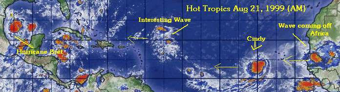
![]()
![]()
![]()
For more information on Cindy see the Current Storm Spotlight for Cindy.
For more information on BRET see the Current Storm Spotlight for Bret.
Some Forecast models:
(NGM, AVN, MRF, ECMWF, ETA)
DoD weather models (NOGAPS, AVN, MRF)
Weather Channel Caribbean Sat Image
Intellicast Caribbean IR Loop
Intellicast Atlantic IR Loop
08:12 AM EDT - 21 August 1999
| One Comment | Read Comments | Newest: 09:23 AM 08-21 EDT
Bret is on its way to becoming a major hurricane that may affect Texas. Hurricane Watches have been set up in Brownsville, up to Baffin Bay, TX down to Tuxpan, in Mexico.
NHC intensity forecasts have the storm becoming a major hurricane (category 3) with 115 Mph Winds. It could become stronger than that.
Needless to say, if you had recreation plans on the coast of South Texas, it would be a good call to cancel them now. We'll be watching. Oh, and if you are reading this from that area and haven't started making preperations. Stop reading now and get them done and plan to move if you have to when and if a warning is placed for your area.
For more information on TD#4 see the Current Storm Spotlight for TD#4.
For more information on BRET see the Current Storm Spotlight for Bret.
Some Forecast models:
(NGM, AVN, MRF, ECMWF, ETA)
DoD weather models (NOGAPS, AVN, MRF)
Weather Channel Caribbean Sat Image
Intellicast Caribbean IR Loop
Intellicast Atlantic IR Loop
10:44 PM EDT - 20 August 1999
| Two Comments | Read Comments | Newest: 12:29 AM 08-21 EDT
We have Hurricane Bret now. And continued strengthening is expected
Track is still uncertain. I probably don't have to write this, but people in Texas and North Mexico should be watching this one like a hawk. People in these areas should go over preperations now in case watches/warnings get thrown up.
More tomorrow...
For more information on TD#4 see the Current Storm Spotlight for TD#4.
For more information on BRET see the Current Storm Spotlight for Bret.
Some Forecast models:
(NGM, AVN, MRF, ECMWF, ETA)
DoD weather models (NOGAPS, AVN, MRF)
Weather Channel Caribbean Sat Image
Intellicast Caribbean IR Loop
Intellicast Atlantic IR Loop
04:49 PM EDT - 20 August 1999
| Three Comments | Read Comments | Newest: 01:18 AM 08-21 EDT
Minor Update 8:45PM - Bret's pressure has dropped 9mbs! As a precaution, the Galveston and Corpus Christi, TX areas have been added to the pop-up list for storm advisories (if they are issued they will show up).
The 3rd storm of the season has formed from TD#4 is the east Atlantic. The main story right now, however is Bret, as now Hurricane Watches are up for some portions of the east coast of Mexico.
Bret continues its northward movement. And strengthening to Hurricane is likely tonight.
For more information on Cindy see the Current Storm Spotlight for Cindy.
For more information on BRET see the Current Storm Spotlight for Bret.
Some Forecast models:
(NGM, AVN, MRF, ECMWF, ETA)
DoD weather models (NOGAPS, AVN, MRF)
Weather Channel Caribbean Sat Image
Intellicast Caribbean IR Loop
Intellicast Atlantic IR Loop
04:15 PM EDT - 20 August 1999
| One Comment | Read Comments | Newest: 08:09 PM 08-20 EDT
Very quick update. Looks as if Bret will be upgraded to a hurricane tonight. And it's still moving northward. Visible satellite pictures seem to indicate an eye attempting to form. People in Texas and the Western Gulf need to pay attention to this one VERY closely, especially if no trends to the west develop by Sunday or so.
The main thing driving Bret at the moment is an upper-level trof which moved into Texas and Mexico yesterday. If this system stops moving away from Bret, it will drive it more northward. And a category 2 Hurricane is not out of the question. There is an upper level low west of Bret as well. If this low were to sink then we could get explosive strengthening in the system. This is also something to watch out for.
More later...
For more information on TD#4 see the Current Storm Spotlight for TD#4.
For more information on BRET see the Current Storm Spotlight for Bret.
Some Forecast models:
(NGM, AVN, MRF, ECMWF, ETA)
DoD weather models (NOGAPS, AVN, MRF)
Weather Channel Caribbean Sat Image
Intellicast Caribbean IR Loop
Intellicast Atlantic IR Loop
09:18 AM EDT - 20 August 1999
| Three Comments | Read Comments | Newest: 11:49 AM 08-20 EDT
Technical Update 12 Noon: Warnings and Advisories are now being monitored for the Brownsville, TX area in the pop up advisories at the top of the news page. This also goes for the text directory. This was done only as a precautionary measure. The pop up advisories have issues with high site load, so if it appears blank or "No Active Storms" then just click on the CFHC news button on the left or reload this frame only. Reminder: CFHC is not an official site nor is it related to any government service or commercial organization. It is just a "hobby" by the two maintainers. By no means take our opinion as the end all, use the links page for more information, or comment yourselves and read other opinions posted.
Short morning update:
Bret continues to linger in the Bay of Campeche gaining strength in lieu of the fact that Tropical Storm warnings remain in effect for most of the east coast of Mexico. The pressure has been dropping and the winds have gone up. The fact that it continues to stall is bothersome as well. Folks in the area, of course, should be vigilant.
TD#4 has maintained itself, or actually moved itself a little south. Some models that tended to turn it northward sooner are now backing off from that, so we may still have a long west tracker out of it.
In short, not too much of a change from yesterday.
Comments, Questions? You don't have to be a weather expert (we aren't). Click on Add a comment next to the story headline.
For more information on TD#4 see the Current Storm Spotlight for TD#4.
For more information on BRET see the Current Storm Spotlight for Bret.
Some Forecast models:
(NGM, AVN, MRF, ECMWF, ETA)
DoD weather models (NOGAPS, AVN, MRF)
Weather Channel Caribbean Sat Image
Intellicast Caribbean IR Loop
Intellicast Atlantic IR Loop
06:24 PM EDT - 19 August 1999
| Two Comments | Read Comments | Newest: 09:23 AM 08-20 EDT
Going against what we thought last night, TD3 has pushed through and beat TD#4 to Tropical Storm status. And therefore Bret remains a threat to the Western Gulf Areas.
TD#4 on the other hand is having a harder time than we first thought. Although it is still holding it's own, the shear has gotten the better of it. However we still think that it will strengthen to Storm and Hurricane status later. But we have a while to track this one.
The future of Tropical Storm Bret is still most likely a threat to Tampico in the form of heavy rains. But once again, it is most important for everyone in the gulf (western gulf especially) to take note.
For more information on TD#4 see the Current Storm Spotlight for TD#4.
For more information on BRET see the Current Storm Spotlight for TD#3.
Some Forecast models:
(NGM, AVN, MRF, ECMWF, ETA)
DoD weather models (NOGAPS, AVN, MRF)
Weather Channel Caribbean Sat Image
Intellicast Caribbean IR Loop
Intellicast Atlantic IR Loop
10:56 PM EDT - 18 August 1999
| Seven Comments | Read Comments | Newest: 09:11 AM 08-19 EDT
Advisories should be showing up shortly for our newest Tropical Depression of the day, TD#4.
This storm will trek westward and likely quickly form into the second Tropical Storm of the season. Will this one or the one in the Gulf be named Bret? I would say, with the current looks of the systems. Bret will be in the East Atlantic.
We Will have time to watch TD#4. More updates tomorrow.
For more information on TD#4 see the Current Storm Spotlight for TD#4.
For more information on TD#3 see the Current Storm Spotlight for TD#3.
Some Forecast models:
(NGM, AVN, MRF, ECMWF, ETA)
DoD weather models (NOGAPS, AVN, MRF)
Weather Channel Caribbean Sat Image
Intellicast Caribbean IR Loop
Intellicast Atlantic IR Loop
05:01 PM EDT - 18 August 1999
| Six Comments | Read Comments | Newest: 10:17 PM 08-18 EDT
Minor Update 8PM:The pressure of TD#3 has lowered to 1007mb according to Recon aircraft (The automated storm advisories and maps on this page will reflect that at 11PM at the next advisory). The highest potential for landfall is still near Tampico Mexico, but everyone around the Gulf should continue to monitor it. TD#4 may form later tonight or tomorrow in the East Atlantic (near the cape Verde). It is looking very impressive now.
Old Update:
After a long spell of no activity in the Atlantic, TD#3 has formed in the Bay of Campeche. The future track of it isn't too solid right now, although the slide into Mexico scenario is still the most likely.
Major players nearby include an Upper low moving westward North of the system which may stall the system in the Bay of Campeche, which would give it more opportunity to strengthen. It also throws wrenches into any certainty with future track. If it goes into Mexico, how long will it have to strengthen? Movement will be slow. Will it forego Mexico and head toward the US? Texas, Louisiana? Good questions. Too early to tell right now. Folks along the entire gulf should watch this one closely over the next few days. Especially those in eastern Mexico, Texas or Louisiana.
Not to be outdone, the system compex in the east Atlantic looks like it could be getting its act together. But this one we will have time to track. August 19/20th is the historical beginning to the peak of hurricane season (which hits its highest frequency September 15th). This year is finally waking up right during the climatological peak. There is still time left for Dr. Gray's predictions to be realized. (Or something close)
Finally, there is a small Tropical Wave in the East Caribbean that may do something when it moves westward. That is fairly unlikely, though.
For more information on TD#3 see the Current Storm Spotlight.
Some Forecast models:
(NGM, AVN, MRF, ECMWF, ETA)
DoD weather models (NOGAPS, AVN, MRF)
Weather Channel Caribbean Sat Image
Intellicast Caribbean IR Loop
Intellicast Atlantic IR Loop
02:17 PM EDT - 18 August 1999
| No Comments
Quick Update 4pm: NHC to begin advisories on Tropical Depression #3 tonight.
Well it seems almost inevitable now that we will have at least two systems to talk about by the end of the week. The one in the Bay of Campeche and the two near the Cape Verde in the East Atlantic.
There are Reservists flying into the system over the Bay of Campeche right now, and it looks like we may have TD#3 before mid day tomorrow. This system likely could do two things. Move quickly to the west and diminish over Mexico before gaining too much strength, and what seems more likely as time passes, it may stall out in the Bay, which throws all bets off. If I were to choose the track now, I would say it will slide West into Mexico before becoming too powerful- I would not count on this however.
Out in the east Atlantic. The wave has emerged off Africa and has held together much better than many in the recent past. There are actually two distinct areas of circulation and one of the two (perhaps both--unlikely, but possible) could form into something in the next few days. The MRF (Most Random Forecast?) even has something coming close to Florida next week -- but this is the MRF which can be pretty sad with storms sometimes.
Do you want to comment on this? Use the "Add Comment" button above this story.
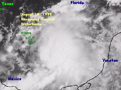
![]()
![]()
![]()
In other news, we've added a bunch of links to our links page recently. Some are very good. I'm of the mindset that you can't have too many Hurricane bookmarks. Check them out.
Some Forecast models:
(NGM, AVN, MRF, ECMWF, ETA)
DoD weather models (NOGAPS, AVN, MRF)
Weather Channel Caribbean Sat Image
Intellicast Caribbean IR Loop
Intellicast Atlantic IR Loop
11:26 AM EDT - 17 August 1999
| Three Comments | Read Comments | Newest: 08:18 PM 08-17 EDT
The story today focuses around a system over the Yucatan which may move into the Bay of Campeche and a system that isn't around (But numerical models forecast it to be).
The System over the Yucatan has a chance when it moves over water, enough so that the Hurricane Center is thinking of sending Recon aircraft out to it since the upper level conditions around it are good for development.
The "phantom" system in the East Atlantic may form according to many of the forecast models later in the week around the Cape Verde area. Right now there is hardly any sign of anything happening, but when this many models suggest formation, it is worth watching.
Some Forecast models:
(NGM, AVN, MRF, ECMWF, ETA)
DoD weather models (NOGAPS, AVN, MRF)
Weather Channel Caribbean Sat Image
Intellicast Caribbean IR Loop
Intellicast Atlantic IR Loop
08:16 AM EDT - 16 August 1999
| No Comments
Another quick update.
The Three Systems:
Gulf of Mexico -- Still around, but very unlikely to develop into anything, as it has diminished since yesterday.
Cape Verde. The wave is still there and is still worth watching. If anything happens it won't be for several days.
West Caribbean - The system there is flaring up again this morning, it is also something worth watching, but yet again nothing imminent.
Otherwise. Hurricane Dora in the Pacific is moving almost due west and may cross over into the west Pacific (moving well south of Hawaii) as a strong Hurricane/Tropical Cyclone. Potentially one of the longest tracking systems ever.
The water temperature around the Bahamas is very warm this year. Warm enough to support a category 5 hurricane from the keys up to the NC coast. With the trend of more westerly movement seen in the Atlantic (and by coincidence Pacific) this year, being on guard this year is especially important. The lack of systems up to this point may help the chances for more powerful systems later on.
08:13 AM EDT - 15 August 1999
| One Comment | Read Comments | Newest: 09:57 AM 08-15 EDT
A quick update this morning.
The wave talked about yesterday has mostly come off Africa, but still has a ways to go before development may occur. It's still worth watching over the next few days.
An old frontal boundry is stalled in the Gulf of Mexico and some convection has been persisting in the area. Although it is too early to draw conclusions now, that's worthy of being watched.
Finally, a rare jump (for us) into the East Pacific, as Hurricane Dora nears Hawaii. Chances are low that it may effect Hawaii, but folks there (or if you have interests there) may want to watch it.
So still nothing happening in the Atlantic currently, but there are at least a few items worth watching.
05:18 PM EDT - 14 August 1999
| Two Comments | Read Comments | Newest: 12:42 AM 08-15 EDT
Normally I don't "wave monger" or promote systems too much before they are ready, but combined with the most recent wave leaving the African coast and the sheer lack of anything to talk about so far this month, I found it worthy to mention this one.
This wave is actually looking pretty good and it may break the long silence. The silence is good as far as damage potential (Which is a good thing), but for trackers like ourselves not even having an ocean spinner has taken its toll with sheer boredom.
The system itself has a fair chance of developing into something, depending, of course, if it holds together once the entire system is over the Atlantic. By tomorrow at this time we should have a much better idea. As it stands now, however:
 (Wave mongering)
(forget it) 0 1 2 3 4 5 6 7 8 9 10 (sure thing)
           [-------------*--------]
This wave is definitely something to watch this week. (Finally)
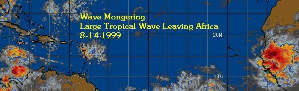
![]()
![]()
![]()
Some Forecast models:
(NGM, AVN, MRF, ECMWF, ETA)
DoD weather models (NOGAPS, AVN, MRF)
Weather Channel Sat Image
08:24 AM EDT - 11 August 1999
| Five Comments | Read Comments | Newest: 09:28 PM 08-13 EDT
I have received yet more email from people suggesting that the season won't be all it's cracked up to be. However, I remind them that last year the second storm was not until August 19th. And after that, it was non-stop for a while. Either we need to reevaluate forecasting methods or we are just a little impatient waiting for the breakout period. I still tend to think the latter, and still generally agree with what Dr. Gray has said.
Do not let your guard down. Currently the tropics are still oddly quiet. Some sinking air in the Central Atlantic may be responsible, but generally there isn't a very hostile (For tropical development) environment anywhere in the basin. On the flip side, there is currently not anywhere particularly favorable either.
The wait continues...
06:17 PM EDT - 06 August 1999
| No Comments
Dr Gray has updated his predictions for this season (Link: Colorado State Dr. Gray), and has kept the numbers the same.
Right now we are still watching what was mentioned in the previous articles. The Gulf and the East Atlantic. Waiting for that other shoe to drop and for something to get going. There is really nothing new to report on it.
There is no reason not to believe that Dr. Gray's forecast won't be pretty close to correct, even at this time of year. Just because the activity has been basically nil up to this point, it is no reason to get complacent. The ingredients for an active season are still there, and when it begins in earnest I believe it will be nearly non stop for a while.
To quote Dr. Gray:
"People should not be lulled into thinking that because we've had a rather slow start to the season
that we're going to get a slow season."
From Colorodo State University and Dr.
William Gray's team
Tropical
Cyclone Seasonal Forecast for
1999 (Climatology/Average in parenthesis)
Named Storms (NS)
(9.3)
14
Named Storm Days
(NSD) (46.9)
65
Hurricanes (H)(5.8)
9
Hurricane Days
(HD)(23.7)
40
Intense Hurricanes
(IH) (2.2)
4
Intense Hurricane
Days (IHD)(4.7)
10
Hurricane
Destruction Potential (HDP) (70.6)
130
Maximum Potential
Destruction (MPD) (61.7)
130
Net Tropical Cyclone
Activity (NTC)(100%)
160
We are now mirroring some Tropical statements and Advisories as well as some Florida Weather advisories at http://flhurricane.com/text. Click on the files there for specific advisories. It is yet another source of alternate advisory links for those keeping track. Also don't forget about our custom Tracking maps (that will be available when storms are active) and the link format of http://flhurricane.com/maps/stormX.html (Where X is a number between 1 and 5 following the TPC's numbering system). We have also fixed a few other pages today and Netscape users will start seeing links to advisories at the top of the news page, IE users still will have the POPUP-text whereas the non-IE users will see just links. Hopefully this will prove useful.
Comments? Let us know!
01:03 PM EDT - 03 August 1999
| No Comments
Still not much going on in the first week of August. However, the activity continues to increase and I still expect to see a storm within two weeks.
Right now, a wave that had the chance to form has moved inland over Central America and won't form on the Atlantic. There is a low pressure trough extending from the northeast Gulf of Mexico (Where it is concentrated) over Florida and up to off the Carolina coast that is worth watching because of the warm water temps. Chances are very low for this to do anything, by the way, and would be very slow to develop. So time to watch there.
Out in the rest of the Atlantic there isn't much going on. There are a few waves coming off Africa, but nothing really striking at the moment. However a few waves that were dampened recently have come back to life as of late. And the latest wave to come off Africa has some circulation in it. So this may change in a few days.
Keep watch.
09:36 AM EDT - 31 July 1999
| One Comment | Read Comments | Newest: 10:15 AM 08-01 EDT
Short update. All the systems talked about in the previous articles never did anything. And once again the Atlantic is strangely quiet this time of year. Similar to last year when in the latter half of the season it cooked up again.
The only thing worth mentioning today is a system Northeast of the Leeward Islands that has very little chance of development, so I don't expect to see anything this weekend.
August starts the climatological ramp up to the peak of the season, so maybe within a week or two the activity may begin.
08:48 AM EDT - 27 July 1999
| Two Comments | Read Comments | Newest: 07:57 PM 07-29 EDT
The area talked about yesterday (2) continues to move across the Atlantic into an area that is neither favorable nor unfavorable for development (probably slightly more on the unfavorable side) and won't develop if at all for a few more days. It's worth watching for sure.
The other two systems yesterday, well #1 hasn't done anything impressive so the chances are even lower. And #3 and #2 more or less merged into one wave. The chances would have been better if they remained separated.
There is another wave coming off the African coast, but it's too early to say if it will hold together.
Bottom line, system #2 from yesterday is the only thing that has a chance right now. If it does develop, it won't be for a few more days. It has quite a bit of hostile area to get through. So the chances on this one have dropped below 5 on the scale.
11:49 AM EDT - 26 July 1999
| Five Comments | Read Comments | Newest: 09:04 PM 07-26 EDT
It may be that the quiet period is starting to end. This morning we have three systems worth talking about.
1. The storm north of Puerto Rico. This system has a rather high surface pressure right now to be forming into anything significant in the near future. However it is worth watching.
Chance of Forming Scale:
(forget it) 0 1 2 3 4 5 6 7 8 9 10 (sure thing)
           [------*---------------]
2. Number 2 has the best chance of all to form and looks like it may within a couple days. There are some negative factors in this area as well that could hold it back. But this is definitely looking the best of the three.
Chance of Forming Scale:
(forget it) 0 1 2 3 4 5 6 7 8 9 10 (sure thing)
           [-------------*--------]
3. Number 3 is trailing behind number 2, but also has a chance to develop. It's future may depend on what happens with #2. Right now it's less likely anything will happen with it.
Chance of Forming Scale:
(forget it) 0 1 2 3 4 5 6 7 8 9 10 (sure thing)
           [-------*--------------]
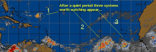
![]()
![]()
![]()
As for future tracks of these systems, it's a bit too early to say for me.
Watch out, though, I think our quiet period is on it's way out.
Some Forecast models:
(NGM, AVN, MRF, ECMWF, ETA)
DoD weather models (NOGAPS, AVN, MRF)
Weather Channel Sat Image
01:53 PM EDT - 21 July 1999
| Three Comments | Read Comments | Newest: 12:25 AM 07-25 EDT
Quite a Quiet Atlantic at the moment. There has been lots of activity but no development.
However within the next two weeks or so I believe the Atlantic will get going again, and we'll start the August season with a bang.
Short update, because there isn't anything to speak of at the moment.
11:52 AM EDT - 18 July 1999
| One Comment | Read Comments | Newest: 08:47 AM 07-19 EDT
The wave talked about in the last few articles has just about made it to land without developing. It missed it's chance.
Just in case you weren't getting tired of this trend, we have another tropical wave in the East Caribbean moving toward the west that may have a chance to develop. We will be watching it again.
Bets anyone?
BTW, we fixed the date/time on this page. Oops!
04:53 PM EDT - 16 July 1999
| No Comments
The system is not looking as impressive this morning as it was the other day when I posted an image.
Right now the chances for development seem about 50/50, meaning it could go either way. But if the upper level high gets in position correctly (which it probably will do) then we could see at least an attempt for development from this system. It's over the Yucatan right now so we won't see anything until it emerges in the Gulf.
Continue to watch it.
We had some technical difficulties overnight which caused the news system to back up to defaults, that's been fixed now.
07:18 PM EDT - 14 July 1999
| No Comments
Wow, Yet another intersting thing in the West Carribean and this one caught us somewhat off guard.
Yes, the flare up in the West Carribean is impressive looking.
Moving generally westward, but currently lacking the low-level closed circulation needed to become a depression.
It could happen, however, so we'll be watching it.
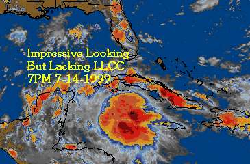
![]()
![]()
![]()
11:32 AM EDT - 11 July 1999
| Two Comments | Read Comments | Newest: 07:30 AM 07-13 EDT
Well, as expected the nortward component discussed earlier never happened, and now the wave is moving across Central America. Ending the chances of it becoming the next Atlantic Tropical Depression. It has possibilites for a Pacific birth.
Otherwise there isn't much going on in the Atlantic again. But as we enter the middle part of July and head into August we should begin to see more activity.
07:27 PM EDT - 10 July 1999
| No Comments
The Tropical Disturbance being tracked is now near Honduras, and may still yet form into a depression as it finally has a low level center. However, it's on the edge of land now so development will be slow.
Movement seems to have a slight nortward component, so it's possible that this may move back over the Gulf of Honduras and possibly into the Bay of Campeche. Although anything significant now would probably not develop due to all the land interference it should not be written off.
It may be a short lived TD like number 2, which formed last weekend briefly and disappeared into Mexico in just as short of time. I've been away this week and John was busy himself so I apologize for the lack of updates and the tracking map for TD#2 failing. (It was such a short storm anyhow).
10:48 PM EDT - 05 July 1999
| Six Comments | Read Comments | Newest: 09:12 AM 07-08 EDT
The tropical wave moving west several hundred miles southwest of the Cape Verde Islands is somthing to keep an eye on. I belive this may be our next depression.
We are having some technical problems with the auto-update on the printable tracking map and the storm spotlight. We are working the bugs out and hopefully it will be fixed by the next Tropical Depression. If not working keep trying back it should be fixed soon after the developement of the next depression.
12:43 AM EDT - 02 July 1999
| Two Comments | Read Comments | Newest: 10:02 PM 07-02 EDT
It's possible that the wave mentioned in the previous articles may indeed yet develop (still I'd put it between a 20-30% chance), but after it passes over land and winds up back in the Southwest Gulf.
If it did develop what would happen next would be hard to say, however any major development out of this system is quite unlikely. Of course, enough to watch.
There is a new feature on CFHC, it's an automatically created tracking map designed for printing. When a storm forms these images will be generated automatically whenever a new advisory comes in. The main reason that we did this was the fact there aren't any nice real time maps designed for printing. Color maps don't work well and white on black maps waste ink. The new maps use a white chart style map with lines overlaid for the track. Designed to minimize ink/toner usage. Currently only one map style is available, but we hope to start offering more maps and more options for each map. (Such as various model forecast tracks, windfield, probabilities, etc.)
When a new storm becomes active you will be able to see the track map one of three ways. One, clicking on the longitude in the "Active Storms" box at the top right of this page. Two, clicking beside the "Public Advisory" on the pop-up text on this page (IE only), and also by clicking on current storm spotlight.
Also there is the direct url option.
http://flhurricane.com/maps/storm1.html Replace the 1 with the storm number (1-5, after 5 it wraps back to 1) This url is designed to be printed in landscape mode on your printer. To see an example (of Arlene's track) click on the link CFHC Arlene Tracking Map Example Note that this probably won't be the final design, and later on you may change the look anyway.
Other sites may use the images, but in return I ask for a link to this page (like if the image is clicked).
In the future other tracking maps will be fully customizable via web forms so that you can create a dynamically updated map to suit your tastes. With different regions highlighted.
I wrote this because there isn't any tracking maps on the net that I could find designed for printing. Well, any without plots already on them. And for those that like to "connect-the-dots" the future customization features will provide an option to place just the points, so you can "connect the dots" as it were.
05:59 AM EDT - 30 June 1999
| One Comment | Read Comments | Newest: 11:14 AM 06-30 EDT
The system in the previous article has missed its opportunity to develop and has almost no chance of doing anything now.
Yesterday two impressive waves emerged from the African coast, but neither has managed to hold together well. It is still too early for these storms.
Nothing else seems interesting at the moment, but we'll keep watching, as always.
08:42 PM EDT - 27 June 1999
| One Comment | Read Comments | Newest: 12:30 AM 06-28 EDT
There is a tropical wave in the central Caribbean that could develop if it persists for two days or so and makes it into the western Caribbean. The shear in this area is low enough to raise some scenarios in this area. One, nothing happens. Two, it develops. I place chances at 20% currently that something will develop currently. Enough to watch, anyway.
As far as the approaching Cape Verde season (When storms start the long journey across the Atlantic off of Africa) it seems to be setting up well except for sea surface temperatures. A pattern is emerging that seems to resemble the 1995 pattern which enabled quite a few systems to track across. However, the potential for landfall from these storms on the US East coast is somewhat higher than it was in 1995. I do not like to be called an alarmist, but it is a good idea in general to make sure you have the insurance premiums paid up. Some well respected sources this year have also concurred with this general statement. So once again I ask everyone to keep a good watch this year.
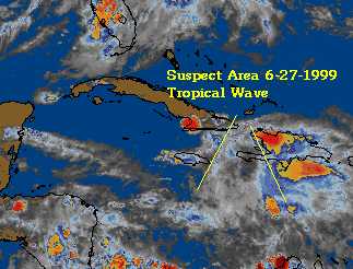
![]()
![]()
![]()
12:38 PM EDT - 26 June 1999
| No Comments
As the month of June is nearing its end, the tropics are quiet.
There really is not much to report on, and not much really threatening at the moment.
We'll keep watching, however. July is usually a slightly more active month than June, but August is when things usually start happening.
12:20 PM EDT - 22 June 1999
| No Comments
One of the better sources for hurricane information on the web has been Millennium Weather ran by Gary Gray. His TranTech model and his discussions that go with it are invaluable.
Recently he has done some work on the Trantech model and has begun to offer pay-for services beyond the free web site. If you have interests in the Coastal areas affected by Hurricanes or work for Emergency Management in some form this may be worth it. Gary does know his stuff, and has an excellent record with the forecast tracks and great discussions. If you are interested check out the web site at http://www.millenniumweather.com/tropical/newstuff.html. I definitely recommend this if you need or want the info.
01:41 PM EDT - 21 June 1999
| No Comments
Currently there just isn't much going on.
But we'll keep watching. An area in the West Caribbean is worth keeping an eye on, and a large tropical wave just came off Africa. Nothing much is expected from that.
However, in the Northeast Pacific basin Hurricane Adrian is about to weaken into a Tropical storm after attaining 100MPH winds earlier. The first storm in the Pacific.
11:25 PM EDT - 17 June 1999
| One Comment | Read Comments | Newest: 05:48 PM 06-18 EDT
Arlene's last advisory was just made. Took a while, a total fish spinner storm that acted strangely at a strange place for June. A freak storm to some.
Other than the bit north of Hispaniola mentioned yesterday (Which still doesn't look like it will form) nothing much is going on. I do have to mention the amount of waves coming off of Africa in June. No storm from Africa on record has formed in the Central Atlantic during June. But water temps are still relatively cool out there, but if the pace keeps up July and August will be maddening.
Another weather note: rain, locally, has been very heavy today. With flash Flood Warnings issued for Brevard. Currently the rain has stopped.
Link to coordinate pairs of Arlene's Track
09:33 PM EDT - 16 June 1999
| No Comments
Arlene, for all purposes, is about done with. It's weakened quite a bit now and it's passing east of Bermuda, with only a very minimal effect on the island.
Looking elsewhere there isn't much worth discussing. A few lows near Hispaniola are upper level and mostly cold-core, which probably won't amount to much. So all is clear outside Arlene for the immediate future. Are eye's are watching, however, for any change.
10:40 AM EDT - 15 June 1999
| One Comment | Read Comments | Newest: 01:50 AM 06-27 EDT
From the latest aircraft recon data, it appears arlene is a little stronger than what the advisories have been stating, closer to 45 Knots. On the west side, which would impact Bermuda more. Even with the shearing. Bermuda is currently under a Tropical Storm Watch, which will probably be upgraded to a Tropical Storm Warning soon with this new Recon data in the mix.
Currently Arlene is meandering southeast of Bermuda, chances are that Bermuda will see some impact. It is a low end Tropical Storm currently, but even these can be major pains. The future direction of Arlene depends a lot on a cold/stationary front inland near the east coast now. People in Bermuda should keep an eye out.
02:05 AM EDT - 13 June 1999
| No Comments
Tropical Storm Arlene is strengthening despite moderate Sea Surface Temperatures. Why? Perhaps Arlene is not Entirely Tropical and has some cold-core characteristics that enables the low point (usually around 80 oF) to be somewhat less.
In fact, Arlene is strengthening impressively and has a real possibilty of becoming Hurricane Arlene. Again, very unusual for this area in the Atlantic in June. (Is there an analog?) Also worthy of note is the fact that the Northeast Pacific Ocean has not even had it's first Tropical Depression yet, and the season started over there May 15th. And right now there still isn't anything promising over that direction. On the other hand there are several interesting areas in the Atlantic being watched.
Last time the Atlantic was more active than the Pacific was in 1995, when we got all the way to Tanya, also the year of Bertha, Erin, Fran, and Opal. So far, the Atlantic is outdoing the NE Pacific.
What does this mean for the future of this season? Above normal activity? Yes. Better chance of a Landfalling system? Yes. Better get prepared now? Yes.
As far as the chances of Arlene messing with the US, they almost don't exist. In other words, It won't happen. But the other interesting aspects of Arlene make it one to track anyway.
Some Forecast models:
(NGM, AVN, MRF, ECMWF, ETA)
Entire Atlantic Basin Satellite photo
03:23 PM EDT - 12 June 1999
| No Comments
Tropical Depression #1 has become the First Tropical Storm of the season and it's a fish spinner. It may trickle to the west a little bit before curving, but I don't think it's any threat to land. Movement will be slow for a while until a short wave kicks it off into the Northeast. 2-3 days from now or so. It's very unusual to have a storm form in this area in June.
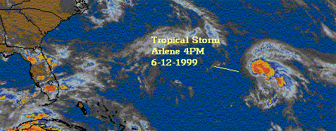
![]()
![]()
![]()
Some Forecast models:
(NGM, AVN, MRF, ECMWF, ETA)
Entire Atlantic Basin Satellite photo
06:25 PM EDT - 11 June 1999
| Four Comments | Read Comments | Newest: 06:41 AM 07-19 EDT
It's likely to become Arlene as well...
See a satellite image from the weather channel here.
Movement is away from land, and it probably won't be much of a threat, however my old prediction for first named storm on June 12th is looking pretty good.
This system gives an opportunity to test my new automation program for this web site. The table on the top right lists current information and is automatically updated. If you have IE 4 or 5 you will see full pop-up advisories avaiable just above the news by clicking. Also by clicking on the latitude in the Current Storms box you will be sent to our new storm position archive file. You can also see it by clicking here. This file is also updated automatically.
If you see any problems let me know, as the code for the program that handles it is constantly being added to and changed by myself.
Some Forecast models:
(NGM, AVN, MRF, ECMWF, ETA)
04:27 PM EDT - 11 June 1999
| No Comments
Visual pics have shown the system NE of Peurto Rico and South of Bermuda to have gotten quite a bit better organized, and I would bet on a Tropical Depression today.
Scale is now up toward the 9 out of 10 range.
More to come after 5PM.
07:51 AM EDT - 11 June 1999
| No Comments
The storm near/over Florida has not formed into anything more than a cool lightning show with some rain. But the storm between the Caribbean (Puerto Rico) and Bermuda still could have a chance, it was looking quite well yesterday. Probably a Fish Spinner (out to sea) if it were to form. Climatologically, however, storms usually don't form north of Puerto Rico in June. Which is a factor against any development.
On the development scale (still under development) of 1-10 (Where 1 is almost no chance and 10 is a "gimmie" that it will form within a few hours) this system rates a 3.
We'll be watching it.
11:14 PM EDT - 08 June 1999
| No Comments
I had some computer downtime for the past 4 days and was unable to update the news page (thankfully the auto-updates still worked), in the meantime something appears to be developing off the coast of Florida, or at least a low exists there.
It's been causing Heavy Rains in Southern Florida, and therefore I have added that area to the Popup advisory list.
Due to the close proximity to land and other factors, this system would be slow to develop into anything. However it is possible for it to become the first Tropical Depression and it must be watched. This may happen if it works its way westward into the Gulf of Mexico. It's important to know that chances are still a little low for development and it would take a while. The models do not offer much hint either. We'll be watching it. There's also a disturbance northeast of Puerto Rico that looks like it probably won't develop now. All in all, the ITCZ in the Atlantic is pretty active for June.
It could be wet here in Central Florida tomorrow.
Intellicast Radar Summary for Florida.
Some Forecast models:
(NGM, AVN, MRF, ECMWF, ETA)
Weather Channel Sat Image
11:27 PM EDT - 04 June 1999
| No Comments
The wave is nearing the South American coast and the extreme southeast Caribbean. Upper level conditions still aren't favorable, but there is a chance that it could effect Florida in the form of rainfall next week, but unlikely that it'll be developed.
WKMG Channel 6 the local CBS affiliate in Orlando is having a Hurricane Special airing tomorrow, June 5, at 7PM. Check that out if you want to see a different take.
11:27 PM EDT - 02 June 1999
| One Comment | Read Comments | Newest: 12:20 PM 06-04 EDT
A short update tonight.
There is a unusually strong tropical wave in the eastern Atlantic for this time of year. Although I do not believe it can develop, it is worth noting for it being so early in June.
A big question this year is will the Bermuda High move further west than normal, thus increasing the chances for a Southeast US hit. (Yes including Central Florida) Comparing some weather factors to previous years shows the storms tend to move further west, which would increase the chance for landfall. Almost Vero Beach north to Savannah has a slightly higher chance than normal. But these are guesses in reality, as anywhere in the Atlantic ring of wind has a better than usual chance with this predicted active year.
Today I fixed and added a few links, moved some things from old sites to here and added the auto-storm table at the top right. The data there is updated automatically, hopefully it won't crash and burn when the first storm comes. I've tested it with old data and it seems to work.
08:10 PM EDT - 01 June 1999
| One Comment | Read Comments | Newest: 10:53 PM 06-01 EDT
Just a quick (but late) reminder that on www.hurricanecity.com the first "internet radio" broadcast of the 1999 Hurricane Season is going on RIGHT NOW.
Interviews with Eric Blake from the Atlantic Tropical Weather Center and Gary Gray, the mind behind Millennium Weather and Trantech are on among others.
12:00 AM EDT - 1 June 1999
| Two Comments | Read Comments | Newest: 10:49 PM 06-01 EDT
This year I will bet on at least one landfalling storm in Florda.
Does this seem like a stretch? Not really when you consider past years and the prediction for this year. Note I did not say how strong any said storm would be on purpose.
Dr. Gray's predictions are above normal and the La Nina pattern looks like it will hold through hurricane season which removes the surpressing effect of the El Nino event. Also remember, last year Florida had three (Thanks Tom Magnuson) landfalling storms. Earl, Georges, and Mitch. Figure in the climatological data on storms and Florida and you also have good support for my bet.
Today is the first day of the 1999 Hurricane season which lasts until November 30th. 1999 is predicted to be an above average year and the CFHC will be watching it throughout the year. More improvements to the site will be happening again in the future and thanks for all the comments. Please use the talkback capability on the stories whenever you have something to add or perhaps correct or comment on.
Currently it is quiet in the tropics, but the tropical situation may improve in the next few days, but without any disturbances with attached lows nothing will occur. So there is nothing currently being watched on the horizon.
Good luck to all in areas threatened by the Atlantic Hurricane basin!
12:04 PM EDT - 30 May 1999
| No Comments
Users of Internet Explorer 4 and 5 will notice a new warning bar that you can click on to get the latest warning and special weather statements immediately without switching pages. These are located above the news stories.
This will include Hurricane bulletins as well. Those who don't use IE still can get this information by using the printer-ready page or going to iwin.
There is less than two days to go until Hurricane Season, so start getting early preps done now.
05:58 PM EDT - 28 May 1999
| No Comments
Now is the time of year for the hurricane specials on the local tv news....
Tonight on the local Orlando ABC affiliate WFTV-Channel 9 at 9PM is a hurricane special done by the Florida News Network and Channel 9 that has been a good source of general info on hurricanes. Especially if you are a new resident to Florida, but it's interesting to see what they emphasize. They are sure to discuss the fact that Gray's predictions are for a heavier than normal storm season among other good things. It's important to note that Former National Hurricane Center directory Dr. Bob Sheets is the "WFTV Hurricane Expert", and is an excellent source of to the point info without the hype. Later tonight at 11:35 they are doing a call in question show with Dr. Sheets. Always interesting.
Thanks to Steve Wolsch for the email reminder about this show tonight. If you know of the other stations doing similar specials please let me know!
07:01 AM EDT - 25 May 1999
| No Comments
The system mentioned in the previous few articles has been sacked. And it was a perfect example of what has become known as Wave Mongering. Which is Hurricane trackers getting itchy to write coordinates down on a map as the hurricane season starts up. Wave Mongerers see any cloud in the Caribbean as a potential for them to warm up the 1999 map. One of the better tools for doing this is using the forecasting models, especially the MRF which tends to go nuts with Tropical storms once in a while. (and the fact that it goes out 10 days)
Wave Mongering isn't a good thing, and we almost fell for it here at CFHC and gave notice to the storm. However, some notice of potential isn't bad, real wave-mongerers turn a jet contrail in the tropics into the next Cat 5 hitting New Orleans, which we will never do.
Well Hurricane season starts in a few days, which is just an official date. Storms can and do form earlier and much later than that date. However it is the time when the Tropical Prediction Center starts up the "Outlooks" which is a good source for getting the feel for systems in the tropics. And yet another tool of the wave-mongers.
Keep an eye out this year, yet stay away from the wave-mongering!
08:49 AM EDT - 24 May 1999
| One Comment | Read Comments | Newest: 02:09 PM 08-10 EDT
Windshear, and quite a bit of it has pretty much kept the disturbance from becoming anything tropical as it remains over the western Caribbean.
That's not to say it has no chance at all, but the chances are going lower the longer it remains getting sheared. Keep watching it, but don't expect much.
Some Forecast models:
(NGM, AVN, MRF, ECMWF, ETA)
Special Tropical Disturbance Statement from the NHC
09:03 PM EDT - 21 May 1999
| No Comments
In the last few hours I have noticed a tropical low associated with the tropical wave approaching the suspect area. The interaction with the trough in the Southwest Caribbean could be something to watch. Wind shear is still hostile for any serious tropical development, but the mixture of events here are interesting in that we could see an early storm. For trackers, it's interesting in the fact that it would be a pre-season storm or depression.
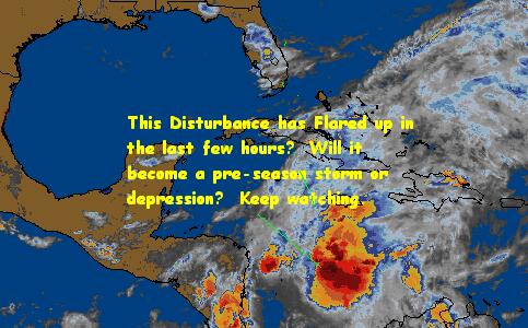
![]()
![]()
![]()
At the very least it will give us a better chance for some rain and wind in Central Florida.
Speaking of which, today toward West Central Florida we received a few Tornadoes that cause some damage. A friend of mine had a tree into the house so I wish him the best of luck.
Some Forecast models:
(NGM, AVN, MRF, ECMWF, ETA)
Special Tropical Disturbance Statement from the NHC
08:36 PM EDT - 20 May 1999
| Four Comments | Read Comments | Newest: 02:16 PM 05-22 EDT
Well well... Early season action in the Caribbean?
It seems like this season is off to an early start, and some of the models (NGM, AVN, MRF, ECMWF, ETA) are suggesting a low forming in the west Caribbean that may become a tropical or hybrid type storm. It probably will bring at least gale force winds to some parts of Florida as the models have it moving across Cuba and near Florida.
Analysis shows a surface trough east of Central America with strong associated convection. Although upper level conditions are somewhat hostile, this won’t matter much if this system goes the hybrid route. If it tends toward a pure tropical system it will have serious difficulties forming.
It is much too early to say if this has any chance as it is not even hurricane season yet. But this developing low is something that all Florida residents and hurricane trackers will want to keep an eye on over the next few days.
Special Tropical Disturbance Statement from the NHC
07:31 AM EDT - 11 May 1999
| One Comment | Read Comments | Newest: 10:57 AM 05-20 EDT
As the 1999 storm season approached it helps to know more facts.
Quite a few people seem to think that using masking tape or some other tape X'd over windows will help in a storm if the windows were to shatter.
08:29 PM EDT - 04 May 1999
| No Comments
A friendly plug for Jim William's and his Hurricane City, which, like last year, has done an outstanding job with his live internet radio broadcasts.
In this tradition he is now (As in right now) doing a live show about the tornadoes that I highly recommend. You can check out the web site at http://www.hurricanecity.com and directly to the broadcast by clicking this link (Needs real audio).
Check it out.
07:37 AM EDT - 04 May 1999
| One Comment | Read Comments | Newest: 10:49 PM 05-05 EDT
Sometimes you see weather that's more severe than normal and you can't believe it. These systems in Oaklahoma consited of a family of tornadoes and some of them were on the high end of the F scale. Such as F4 and F5, which even for "Tornado Alley" are highly unusual in such number.
Once again the danger in Tornadoes is of the unpredictability and strong winds inside the funnel that Hurricanes find hard to match. However, destruction is usually more with Hurricanes due to the size. Andrew is still the costliest (in terms of money) natural disaster in America. But you can prepare for these storms.
A lot of the people in OK, KA had preperations, had the storm cellars, but these tornadoes were not the norm and still some lives were lost in this overnight system. As of right now (7:30AM) some parts are still under warnings. If they did not have the system they did more lives would have been lost. Even so, this emphasizes the need for severe weather preperations. Florida had it's own big outbreak of tornadoes last year that should serve as a reminder that Florida is a dangerous weather place. Don't take the fact that we have not had a major hurricane in the space coast in a while. I've heard people say that the federal government chose the area it did for the space center because of the low frequency or lack of major hurricanes in the area. THIS IS A MYTH. There have been major hurricanes to hit Brevard in the past, when it was less populated. And cocoa beach and merritt island have been under water because of the storms before, just not recently.
See the radar loop of a major tornado near Oaklahoma City
11:44 AM EDT - 03 May 1999
| One Comment | Read Comments | Newest: 11:47 AM 05-03 EDT
I've heard the predictions of some, which suggest that the early season could be more active than usual. Would that suggest something like a storm or depression in late May? Unlikely. June, somewhat more likely, and July almost definate.
My predictions for this year is slightly less than what Dr. Gray predicts at 13 Named Storms, 9 Hurricanes, and 3 intense hurricanes. I also believe we will see the first storm in June. However if an early storm forms before then all bets are off.
With less than a month to go before the start of the Atlantic Hurricane season, it's time to get ready. (East Pacific starts May 15th). Most predictions have this year as being active, so not being prepared (especially if you read this site) is very unwise.
What do you think? Use the new talkback functions on the timeline in this article to discuss this and ask questions. In the future it will allow you to post your own reports and comments on active storms.
We have also added some Hurricane Tracking Software and a few other links to the links page.
04:40 PM EDT - 23 April 1999
Well, part one of our new system for this year is in place.
You may or may not notice the new headline listings and the last updated line at the top of the page, but now we have begun using the our new program (still in development) that allows news updates to be a little better.
More will be coming soon, this year we will be fully prepared for the best updates.
As a side note, let me note the "Hurricane History" message board on America On-Line. This is the only reason I keep my AOL account alive (BYOA). You can get to it via keyword "weather" and by selecting Chat and Messaging and looking for the "Hurricane History" message board. (Not the regular hurricane board). Some very good discussions come from that and part of which I use in the updates here.
So keep looking for new stuff coming soon!
10:16 PM EDT - 18 April 1999
In preperation for the 1999 hurricane season we have relocated our main site address
to http://www.flhurricane.com
as our new easier to remember site address. In the future we hope to add more because of this move. The site will still be called Central Florida Hurricane Chasers, but we may add more later.
One plan calls for location reports, or news that you can write on here to compliment what we write, or to comment on each news update. You will see this soon.
All the other site addresses will still work for now, but we recommend changing your bookmarks to www.flhurricane.com as others may drop out in time. I'd recommend marking all 4 sites, in fact, in case problems arise during storm alerts, you will have backup sites to go to.
1999 should be a busy season for us, and with just over a month to go until the official start we
are beginning to gear up for it.
Thanks to all of you for reading, and if you have any comments let us know or use the guestbook!
We are also aware that the news ticker does not work properly in netscape, we hope to have that fixed by the start of the season. It still works fine with IE, however.
04:08 PM EDT - 8 April 1999
From Colorodo State University and Dr.
William Gray's team
Tropical
Cyclone Seasonal Forecast for
1999 (Climatology/Average in parenthesis)
Named Storms (NS)
(9.3)
14
Named Storm Days
(NSD) (46.9)
65
Hurricanes (H)(5.8)
9
Hurricane Days
(HD)(23.7)
40
Intense Hurricanes
(IH) (2.2)
4
Intense Hurricane
Days (IHD)(4.7)
10
Hurricane
Destruction Potential (HDP) (70.6)
130
Maximum Potential
Destruction (MPD) (61.7)
130
Net Tropical Cyclone
Activity (NTC)(100%)
160
Coastal Region
TS
Category 1-2
HUR Category 3-4-5
HUR All
HUR Named
Storms
Entire
U.S.�coastline
87% (1.57)
67% (1.12)
72% (0.73)
94% (1.85)
97% (3.42)
Gulf Coast
69% (0.89)
54% (0.55)
40% (0.35)
72% (0.90)
92% (1.79)
Florida plus East
Coast
57% (0.68)
57% (0.57)
54% (0.38)
80% (0.95)
92% (1.63)
10:06 AM EDT - 31 March 1999
I was unable to go this year (unfortunately), so I'll have to
rely on reports of what is going on. Word has it, however, that
the outlook for the 1999 hasn't changed much from earlier
predictions.
The conference ends April 2.
04:04 PM EDT - 12 March 1999
02:03 PM EDT - 9 March 1999
http://volusia.org/fireservices/
- Volusia County Fire Services
http://www.wesh.com WESH
Channel 2
http://www.wftv.com WFTV
Channel 9
http://www.nj-center.com
Daytona Beach News Journal
02:02 AM EDT - 1 March 1999
Hurricane season will be approaching within a couple months
again, so it is around the time we will begin slowly adding some
new features to the CFHC. Today we updated the General Info page
to reflect 1999 information, and later on we plan on adding other
pages, new code to help with finding data, and possibly archiving
old storm data in several forms.
The season outlook hasn't changed much since the last update.
Also we have added the season countdown.
02:00 AM EDT - 1 January 1999