Archived Year: [1996] [1997] [1998] [1999] [2000] [2001] [2002]
July... No Named Storms
09:28 AM EDT - 27 July 2001
| Fifty-one Comments | Read Comments | Last 20 Comments | Newest: 10:16 AM 07-29 EDT
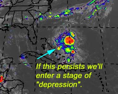
Barring no last minute surprises, looks like we'll go through July with out a named system. However, this benefit will be short lived.
SNONUT (from one of our hosted sites), is predicting early August activity from the Cape Verde. And judging by what I've seen lately, I have no reason to doubt it. (Which, of course, is when I'm out of town 3-15th (hemisphere even))) Add to that a pattern is setting up which may be less friendly for recurving of storms... So it's likely storms will stay further south this year. Which means the Southeast, including Florida could have some close calls this year.
For now, though. Nothing much worth watching, although the activity with the waves coming off Africa will get more and more interesting.
August could ramp up quickly, so be on the lookout.
BR>
NRL Monterey Marine Meteorology Division Forecast Track of Active Systems (Good Forecast Track Graphic and Satellite Photos)
NASA GHCC Interactive Satellite images at:
[NAtl visible] (visible -- Daytime Only) [NAtl infrared] (infrared), and [NAtl water vapor] (water vapor)--Nasa source.
Defiant Visible Infrared More...
Other commentary at: Mike Anderson's East Coast Tropical Weather Center - Accuweather's Joe Bastardi - Robert Lightbown/Crown Weather Services - SCOTTSVB's Hurricane Update Center - Jim Williams' Hurricane City - Gary Gray's Millennium Weather - Even More on our Links Page
Some Forecast models:
(NGM, AVN, MRF, ECMWF, ETA)
DoD weather models (NOGAPS, AVN, MRF)
AVN, ECMWF, GFDL, NOGAPS, UKMET
- [mac]
Nothing Imminent
01:03 PM EDT - 25 July 2001
| Fourty-two Comments | Read Comments | Last 20 Comments | Newest: 12:44 PM 07-27 EDT
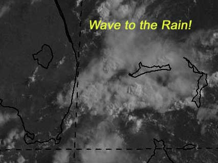
We're still on track for a no-named-storm July, but with a few complications. Namly a system Southwest of Cuba...
(forget it) 0 1 2 3 4 5 6 7 8 9 10 (sure thing)
           [------*---------------]
With not much of a chance to develop due to surrounding conditions at the moment. Still we'll need to watch it just because of the area it's in.
(forget it) 0 1 2 3 4 5 6 7 8 9 10 (sure thing)
           [----*-----------------]
- [mac]
Goes M Is Up
08:15 AM EDT - 23 July 2001
| One hundred thirty-seven Comments | Read Comments | Last 20 Comments | Newest: 01:38 PM 07-25 EDT
Yesterday the new GOES M satellite was launched, which is the last of that "generation" satellite, which will help track storms across the globe. Find out more on the GOES Web Site.
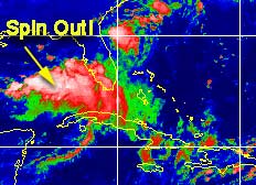
This weekend we had a little rain. Which is chipping away at our drought conditions, and actually start to get our lakes back up. This stalled front, though caused a low to develop west of us. But the conditions were (and still are not) favorible for development.
It didn't stop it from trying, however, and the west coast had a windy day and plenty of rain.
 |
||
Development Potential for Gulf Low
(forget it) 0 1 2 3 4 5 6 7 8 9 10 (sure thing)
           [--*-------------------]
- [jc]
Lets Go for no Named Systems in July!
10:35 AM EDT - 20 July 2001
| Fourty-five Comments | Read Comments | Last 20 Comments | Newest: 07:21 AM 07-23 EDT
Right now is the calm before the storm... so instead of talking about all the amazing systems we are watching and a cool sat graphic of it, instead we have the infinitely more interesting photo of a bunch of happy walruses...
 |
||
(forget it) 0 1 2 3 4 5 6 7 8 9 10 (sure thing)
           [-*--------------------]
- [mac]
A Lot of "Maybe"
02:43 PM EDT - 16 July 2001
| Twenty Comments | Read Comments | Newest: 12:49 AM 07-20 EDT
What we have this week is a lot of maybe something, nothing definite, and nothing immediate. However it's nearing the latter half of July, so we normally want to start looking around more, although we are still one month away fromt the start of the peak season.
Right now take a look...
 |
||
(forget it) 0 1 2 3 4 5 6 7 8 9 10 (sure thing)
           [-*--------------------]
(forget it) 0 1 2 3 4 5 6 7 8 9 10 (sure thing)
           [--*-------------------]
(forget it) 0 1 2 3 4 5 6 7 8 9 10 (sure thing)
           [---*------------------]
- [mac]
Less on TD#2
09:58 AM EDT - 13 July 2001
| Twelve Comments | Read Comments | Newest: 12:51 PM 07-16 EDT
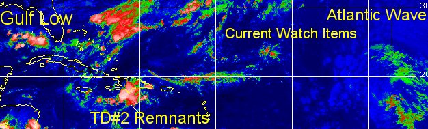
The GFDL got it right, the storm did take a nosedive. Tropical Depression Two will not regenerate. It's going to be nothing over the weeekend. Still the front that may stall over the waters next week may make it interesting for us then. But nothing else I can see over the next few days.
The will be lots rain here in Florida today, and less so over the weekend, so have a good weekend folks.
NRL Monterey Marine Meteorology Division Forecast Track of Active Systems (Good Forecast Track Graphic and Satellite Photos)
NASA GHCC Interactive Satellite images at:
[NAtl visible] (visible -- Daytime Only) [NAtl infrared] (infrared), and [NAtl water vapor] (water vapor)--Nasa source.
Defiant Visible Infrared More...
Other commentary at: Mike Anderson's East Coast Tropical Weather Center - Accuweather's Joe Bastardi - SCOTTSVB's Hurricane Update Center - Jim Williams' Hurricane City - Gary Gray's Millennium Weather - Even More on our Links Page
Some Forecast models:
(NGM, AVN, MRF, ECMWF, ETA)
DoD weather models (NOGAPS, AVN, MRF)
AVN, ECMWF, GFDL, NOGAPS, UKMET
- [mac]
More on TD#2
09:58 AM EDT - 12 July 2001
| Twenty-four Comments | Read Comments | Last 20 Comments | Newest: 03:08 PM 07-14 EDT
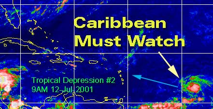
Tropical Depression #2 is looking a litte different this morning, a little more concentrated and more tropical looking. I expect to see Barry today.
For it's future, it now appears as if it will head to the Eastern Leeward islands an a minor system. Many models have it entering and staying in the Caribbean. Climatology isn't favorible for it, and if it does creep north it'll have to deal with the mountains of Hispaniola.
It won't get much chance to strengthen over that Island. There is enough to suggest it could reach minor hurricane strength, so folks will need to watch.
Persistence again will be paramount. Beyond that, it still could effect Florida in some way next week if the stalled out front does not itself. But if it does go through the caribbean and Hispaniola it won't have enough to recover. In any case, the Caribbean needs to watch this one very closely for right now, and we may later depending on what path this thing takes. It probably won't touch us at all, but the chance is still there so I mention it.
 |
||
- [mac]
TD#2 Forms in East of the Caribbean
10:54 PM EDT - 11 July 2001
| Eleven Comments | Read Comments | Newest: 08:46 PM 07-28 EDT
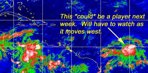
This week will be interesting too. TD#2 has formed now. And will be tracked. The Caribbean should monitor this system. As for its future, it may have some trouble in the future, but I expect it to hold its own for a while. And probably will increase to Barry soon. Later on in the period it will run into windshear and most likely have problems. I expect it to skirt north of the islands, but they will need to watch it. Especially in the Northern Central Caribbean islands.
Formed 11.5N 43.9W
We'll be watching.
Caribbean Hurricane Page - Updates from the various Caribbean Islands.
NRL Monterey Marine Meteorology Division Forecast Track of Active Systems (Good Forecast Track Graphic and Satellite Photos)
NASA GHCC Interactive Satellite images at:
[NAtl visible] (visible -- Daytime Only) [NAtl infrared] (infrared), and [NAtl water vapor] (water vapor)--Nasa source.
Defiant Visible Infrared More...
Other commentary at: Mike Anderson's East Coast Tropical Weather Center - Accuweather's Joe Bastardi - SCOTTSVB's Hurricane Update Center - Jim Williams' Hurricane City - Gary Gray's Millennium Weather - Even More on our Links Page
Some Forecast models:
(NGM, AVN, MRF, ECMWF, ETA)
DoD weather models (NOGAPS, AVN, MRF)
AVN, ECMWF, GFDL, NOGAPS, UKMET
- [mac]
Next Week may be Interesting
08:45 AM EDT - 11 July 2001
| Fourty-three Comments | Read Comments | Last 20 Comments | Newest: 05:43 PM 07-28 EDT
Space Shuttle Atlantis on mission STS-104 s a launch for the International Space Station scheduled tomorrow, the first with the new Block II style engines. Weather could be a factor today and tomorrow, so it could be pushed back until Friday, July 13. Along with the new engines the Moroccan emergency landing site will be nonfunctional too (due to threats). I for one hope the weather and rain holds off enough for it to get off tomorrow fine.
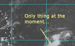
It's still blasé this week as far as storms, but it doesn't mean there is nothing to watch out for. I give you the wave near 40 degrees west...
 |
||
(forget it) 0 1 2 3 4 5 6 7 8 9 10 (sure thing)
           [---------*------------]
- [mac]
Back to nothing
03:14 PM EDT - 09 July 2001
| Four Comments | Read Comments | Newest: 05:10 PM 07-11 EDT
There is nothing going on in the Atlantic tropics to discuss. The only thing even apparant on the satellite is some disturbed areas to the east of the Caribbean. The shear is too much right now for anything to happen there at the moment.
Over the weekend the server for flhurricane was upgraded (double ram and hd space) That gives us much better breathing room for the remainder of the season, and should make it a slight bit faster.
NASA GHCC Interactive Satellite images at:
[NAtl visible] (visible -- Daytime Only) [NAtl infrared] (infrared), and [NAtl water vapor] (water vapor)--Nasa source.
Defiant Visible Infrared More...
Some Forecast models:
(NGM, AVN, MRF, ECMWF, ETA)
DoD weather models (NOGAPS, AVN, MRF)
AVN, ECMWF, GFDL, NOGAPS, UKMET
- [mac]
Upper Level Bahamas? Will it Persist?
09:51 AM EDT - 03 July 2001
| Fourty-eight Comments | Read Comments | Last 20 Comments | Newest: 01:55 PM 07-08 EDT
There is a mostly upper level system near the Bahamas that has exploded this morning, and may want to take a dive and try to become a lower level system. Unlikely, still, (UL winds are rather high) but definitely worth watching during this holiday centered week. In either case it will bring rain and some wind to Florida later on this week. Development really depends on persistence again. If this keeps up (Especially overnight) then we may have something develop.
I'll be out of town the remainder of the week so access to the site will be spotty. If something develops we'll do our best.
My development potential scale for the wave approaching florida:
(forget it) 0 1 2 3 4 5 6 7 8 9 10 (sure thing)
           [-------*--------------]
 |
||
- [mac]
Persistence
09:18 AM EDT - 02 July 2001
| Eighteen Comments | Read Comments | Newest: 11:09 AM 07-03 EDT
Didn't happen, so the Gulf low has become part of another system. Chances of development now:
(forget it) 0 1 2 3 4 5 6 7 8 9 10 (sure thing)
         * [----------------------]
- [mac]
Gulfatude
07:13 PM EDT - 01 July 2001
| Fourteen Comments | Read Comments | Newest: 06:22 AM 07-02 EDT
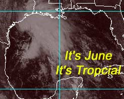
In continuing with the tradition of this site mangling gulf storm forecasts, we now have a 180 from this morning. A depression may be forming from the low that's been drifting slowly westward. Emphasizing the need to monger in the gulf, this system has exploded during the day, and now I think the chances of us having a depression or TS tomorrow are fairly good. Panhandle/Alabama be aware.
Development potential for this wave.
(forget it) 0 1 2 3 4 5 6 7 8 9 10 (sure thing)
           [----------------*-----]
- [mac]
2001, Month 2
04:44 AM EDT - 01 July 2001
| Nine Comments | Read Comments | Newest: 07:16 PM 07-08 EDT
June 2001 will be remembered for Allison, a very destructive, but never strong wind-wise, Tropical Storm. This was the only tropical even in June, and the first part at that. Only classified as a tropical system for a very short amount of time, it managed to slide into the Northeastern Texas coast and presume to dump unbelievable amount of rain at and around this area and up and along nearly every state from Texas to Maine.
It caused roughly two billion in damage estimates along the way and too many flood related deaths all for a rather weak system. I’m unsure if the name will be retired (since it was only a Tropical Storm), but this brings the case for a change in the manner in which it is done if not.
July is up next, and it appears the first week will be slow, and it may not pick up until later in the month. July is still not the peak for hurricane activity, as that begins in mid-August. For sure, many factors will continue to inhibit things forming along the cape Verde route for another few weeks at least. The activity won’t begin in earnest until past mid-August. Between now and then we may get one or two systems still pop up. But don’t look for them to the east of the Caribbean. Water temperatures aren’t there yet and it’s too hostile at the moment. If anything happens it would be near the east coast, in the Gulf or Caribbean.
The wave from a few days ago was a bust, Florida received very little rain from the system, and it moved into the Gulf. Nothing will come of it, I think.
Everyone enjoy the holiday this week, and keep watching the tropics.
NASA GHCC Interactive Satellite images at:
[NAtl visible] (visible -- Daytime Only) [NAtl infrared] (infrared), and [NAtl water vapor] (water vapor)--Nasa source.
Defiant Visible Infrared More...
Some Forecast models:
(NGM, AVN, MRF, ECMWF, ETA)
DoD weather models (NOGAPS, AVN, MRF)
AVN, ECMWF, GFDL, NOGAPS, UKMET
- [mac]
Droughtbusters!
09:47 AM EDT - 26 June 2001
| Twenty-six Comments | Read Comments | Last 20 Comments | Newest: 02:30 AM 07-01 EDT
There is a tropical wave approaching south Florida now that will give us more much needed rain, and hopefully less lightning. It will start in south Florida and move northward, hopefully giving us a good soaking. We are still at drought levels despite all the afternoon storms. The storms have been lightning intense also.
My development potential scale for the wave approaching florida:
(forget it) 0 1 2 3 4 5 6 7 8 9 10 (sure thing)
           [-*--------------------]
(forget it) 0 1 2 3 4 5 6 7 8 9 10 (sure thing)
           [--*-------------------]
 |
||
- [mac]
Nothing going on.
09:30 AM EDT - 23 June 2001
| Twelve Comments | Read Comments | Newest: 07:54 AM 06-26 EDT
Only have one slight bit of action going on nearing the Caribbean, but like most systems this time of year it isn't all that likley do that much. It is worth noting hower because of some of the characteristics that it is showing. The system close to 50W, will be the only thing going on for the next few days.
On my scale for development potential:
(forget it) 0 1 2 3 4 5 6 7 8 9 10 (sure thing)
           [----*-----------------]
 |
||
- [mac]
Second Half of June
06:16 PM EDT - 18 June 2001
| Nine Comments | Read Comments | Newest: 08:30 AM 06-23 EDT
The second half of june should be much quieter. Rain has been occuring nearly every day in Central Florida for the past few weeks. Which is helping quite a bit from our dry spell. It still will take a while of this to get out of it, however.
Allison is gone for good now, after soaking many states and causing flooding as well as 45 deaths. That system will hopefully be our only June storm.
The only thing worth watching now is a wave to the east of the Caribbean, in the Atlantic, which is pretty well put together. It is entering an area hostile for development. It will have to be watched if it makes it across the Central Caribbean.
- [jc]
The Storm that Would not Die
10:26 PM EDT - 13 June 2001
| Twenty-nine Comments | Read Comments | Last 20 Comments | Newest: 03:28 PM 06-18 EDT
The remnants of Allison are still haunting the Southeast US, near North/South Carolina. Regeneration is still a possibility, although somewhat unlikely. It will remain a fairly strong storm center regardless.
Flooding has happened from Texas to the Panhandle, with deadly consequences. This storm will be a memorable one for many, as the effects were spread across a fairly wide area, even though the storm itself never was more than a Tropical Storm.
Tropical systems, and even moreso hybrids like Allison, you always expect the unexpected and must not let your guard down. Water was the killer here from this terribly slow moving storm.
Otherwise there isn't much in the Atlantic other than a wave near the central part of it. The time of the year is not right for anything to come of that, however.
NASA GHCC Interactive Satellite images at:
[NAtl visible] (visible -- Daytime Only) [NAtl infrared] (infrared), and [NAtl water vapor] (water vapor)--Nasa source.
Defiant Visible Infrared More...
Some Forecast models:
(NGM, AVN, MRF, ECMWF, ETA)
DoD weather models (NOGAPS, AVN, MRF)
AVN, ECMWF, GFDL, NOGAPS, UKMET
- [mac]
Allison Regenerating in Atlantic?
12:39 PM EDT - 12 June 2001
| Twenty Comments | Read Comments | Newest: 10:15 PM 06-13 EDT
Not likely.
Allison regenerating in the Atlantic was a possibility, but it won't happen this time. It has stuck together even over land because of its hybrid storm nature. Even if it did, it would move out and away. Still an amazing tale for this horribly destructive flooding tropical storm.
Other than this possiblity there isn't much going on in the tropics now, which is how we like it.
NASA GHCC Interactive Satellite images at:
[NAtl visible] (visible -- Daytime Only) [NAtl infrared] (infrared), and [NAtl water vapor] (water vapor)--Nasa source.
Defiant Visible Infrared More...
Some Forecast models:
(NGM, AVN, MRF, ECMWF, ETA)
DoD weather models (NOGAPS, AVN, MRF)
AVN, ECMWF, GFDL, NOGAPS, UKMET
- [mac]
Allison Flood
08:17 PM EDT - 09 June 2001
| Eleven Comments | Read Comments | Newest: 07:44 PM 06-11 EDT
Former Tropical Storm Allison is causing a major flood near Houston Texas. The first storm of the season and it has been a major story so far dumping feet of rain in the areas of Southeast Texas and Louisiana.
Allison just doesn't want to die. It's no longer a depression, but may slip off the coast, which may cause it to regenerate, yet still not moving much. Allison, an early tropical storm, has caused amazing amounts of destruction and disruption already. If this regenerates over the Gulf, it will not be good. 20.58 inches of rain at Houston/Hobby airport.
This emphasizes the point that even relatively "weak" tropical systems can cause havoc. We wish everyone in the Texas/Louisiana area the best of luck and God bless.
NASA GHCC Interactive Satellite images at:
[NAtl visible] (visible -- Daytime Only) [NAtl infrared] (infrared), and [NAtl water vapor] (water vapor)--Nasa source.
Defiant Visible Infrared More...
Some Forecast models:
(NGM, AVN, MRF, ECMWF, ETA)
DoD weather models (NOGAPS, AVN, MRF)
AVN, ECMWF, GFDL, NOGAPS, UKMET
- [mac]
More Predictions Wave
08:30 AM EDT - 07 June 2001
| Twenty-six Comments | Read Comments | Last 20 Comments | Newest: 05:31 PM 06-09 EDT
Dr Gray and his team at Colorado State University has updated his forecast to include two more (12 total) named storms. One of these has already occured. He's added one more hurricane and one more major Hurricane. This is due to factors such as colder than expected Pacific temperatures (La Nada), and more.
| Tropical
Cyclone Forecast Colorado State University / Dr. William Gray |
Mean Average Year |
07-June-2001 |
|---|---|---|
| Named Tropical Storms and Hurricanes | 9.3 | 12 |
| Named Storm Days | 46.9 | 60 |
| Hurricanes | 5.8 | 7 |
| Hurricane Days | 23.7 | 30 |
| Intense Hurricanes (Cat 3+) | 2.2 | 3 |
| Intense Hurricane Days | 4.7 | 5 |
- [mac]
Tropical Storm Allison
Updated 10:15PM - Originally
05:58 PM EDT - 05 June 2001
| Four Comments | Read Comments | Newest: 03:33 AM 06-09 EDT
Mike's 10:15PM Update:
Allison is causing quite a bit of flooding problems in coastal texas and bringing bad weather to the area. The center is exposed and still just offshore, and all the convection is to the north and west. Allison won't strengthen anymore since it's getting pulled apart to the north.
It's an interesting wake up call to realize that we've already had the first named storm. It caught are system unprepared (See Tropical Storm "Intermediate" an NHC wording problem) This blew my prediction of no named systems in June, but plenty of others suggested it could be possible for some other reasons which were just as valid. I won't do any crawfishing with that. The average is every other year for a June storm, and we got it this "other year". This has no bearing on the rest of the season, though. The Gulf and Western Caribbean is the climatological most likely spot for these storms in June.
The source of Allison was an area that slipped over central america, festerd over the bay of campeche for a while and then looked to fall apart. However, it managed to make a rather amazing comeback overnight and became a strange hybrid like tropical system and eventually a tropical storm. This near rogue storm emphasized just how quickly the situation can change within the tropics sometimes, and why it's worth it to check up on it from time to time.
John's original Update:
Early season Tropical Depression Allison (First named storm of the Atlantic hurricane season)has formed in the western Gulf of Mexico along the Texas coast and is moving to the north near 12 mph. A TROPICAL STORM WARNING IS IN EFFECT FOR THE TEXAS AND LOUISIANA GULF COASTS FROM SARGENT TEXAS TO MORGAN CITY LOUISIANA.
Strengthening?? Keep those comments coming.
Joe Bastardi's season predictions should be up today.
The Weather Channel's Storm week focuses on Hurricanes tonight at 9PM EDT.
- [jc]
Tropical Depression Forming in Gulf of Mexico
11:46 AM EDT - 05 June 2001
| Eighteen Comments | Read Comments | Newest: 05:24 PM 06-05 EDT
I may be wrong about the first named system timeframe. We'll most likely have one in June... and early at that... like today. It's possible we have a tropical storm or depression in the Northwest Gulf of Mexico. It's moving slowly toward the Texas and Louisiana coastlines.
This morning some organization has occurred, and we may have our first tropical depression of the season this afternoon. It may even be a storm. Any comments on this early action?
 |
||
- [mac]
As the Season Starts...
12:52 PM EDT - 03 June 2001
| Eleven Comments | Read Comments | Newest: 12:32 PM 06-05 EDT
The season has started off uneventful, with the exception of the Bay of Campeche in the Gulf of Mexico. There is a mass of clouds there that could form if the weather conditions above it were better. Thankfully they aren't, so nothing will form. It will bring some rain to South Florida though, which is a welcome change.
On Average a storm forms in June every other year, so in that respect (statistically) we are due for one. I don't think we will though. The Atlantic is looking about as average as average can get this year. We will see in the later season when this pattern will take hold or not. I do think the chances of a land falling system are slightly greater this year than last even though the number of storms is projected to be average. Even then, the most likely place is along the East Coast from Florida to North Carolina. The Gulf just slightly less. As many people note, it only takes one system to turn an otherwise average year into one for the books.
Gary Gray over at Millennium Weather has put out his 2001-- Seasonal Forecast, he predicts one less than William Gray in the number of storms. Citing analog years in the past that compare to this year. He makes the point that Dr William Gray at Colorado State does the best job with the predictions, and I definitely agree.
On Friday I had a good short conversation on Jim William's Hurricane City / WABN Audio Show. I thank him for letting me speak a little about this season and what we do. Jim did a great job with his 3 hour season opener show.
- [mac]
The 2001 Atlantic Hurricane Season has Begun
09:45 AM EDT - 01 June 2001
| One Comment | Read Comments | Newest: 12:29 PM 06-03 EDT
The 2001 Atlantic Hurricane Season Starts today, with nothing of note going on. The most active times for hurricanes is between August 15 and October 15th. Early June storms are relatively rare, and I don't expect to see any named systems this month. July is another issue, but the number of storms isn't. For example, Hurricane Andrew in 1992 didn't form until late August. It only takes one to cause problems, and the lack of storms now has absolutely nothing to do with what may happen in the later season.
The last day of the Atlantic Hurricane Season is on November 30th.
As Hurricane Season starts, a recent Red Cross poll conducted on coastal residents in hurricane prone areas finds that only 58% of us are concerned about the
systems, and about half actually have a plan for evacuation. Of those with
plans, 80% of them have taken into account their kids and 64% have for their
pets.
The numbers will mean roughly half of the folks in storm prone areas may be blind-sided if a major hurricane does make landfall on them.
Here is the first Tropical Outlook for the 2001 Atlantic Hurricane Season:

000
ABNT20 KNHC 010906
TWOAT
TROPICAL WEATHER OUTLOOK
NATIONAL WEATHER SERVICE MIAMI FL
530 AM EDT FRI JUNE 01 2001

FOR THE NORTH ATLANTIC...CARIBBEAN SEA AND THE GULF OF MEXICO...

TODAY MARKS THE FIRST DAY OF THE ATLANTIC HURRICANE SEASON...WHICH
WILL RUN UNTIL NOVEMBER 30TH.  LONG-TERM AVERAGES FOR THE NUMBER OF
NAMED STORMS AND HURRICANES ARE 10 AND 6...RESPECTIVELY.

THE LIST OF NAMES FOR 2001 IS AS FOLLOWS...

NAME          PRONUNCIATION      NAME          PRONUNCIATION
------------------------------------------------------------
ALLISON                          LORENZO
BARRY                            MICHELLE
CHANTAL       SHAN-TAL           NOEL
DEAN                             OLGA
ERIN          AIR-IN             PABLO         PA-BLOW
FELIX         FEEL-IX            REBEKAH
GABRIELLE     GAH- BREE-EL       SEBASTIEN     SAY-BAS-TYAN
HUMBERTO      OOM-BAIR-TOE       TANYA         TAHN-YA
IRIS          EYE-RIS            VAN
JERRY                            WENDY
KAREN

THIS PRODUCT...THE TROPICAL WEATHER OUTLOOK...IS ISSUED FOUR TIMES A
DAY...AT 530 AM...1130 AM...530 PM...AND 1030 PM EASTERN TIME.  IT
BRIEFLY DESCRIBES SIGNIFICANT AREAS OF DISTURBED WEATHER AND THEIR
POTENTIAL FOR TROPICAL STORM DEVELOPMENT.

A SEPARATE PRODUCT...THE SPECIAL TROPICAL DISTURBANCE STATEMENT
...MAY BE ISSUED AT ANY TIME TO DESCRIBE STRONG...FORMATIVE WEATHER
SYSTEMS THAT HAVE NOT YET REACHED TROPICAL DEPRESSION STATUS.  THE
SPECIAL TROPICAL DISTURBANCE STATEMENT IS ISSUED UNDER THE WMO
HEADER WONT41 KNHC AND UNDER AWIPS HEADER MIADSAAT

A STANDARD PACKAGE OF PRODUCTS...CONSISTING OF THE TROPICAL CYCLONE
PUBLIC ADVISORY...THE FORECAST/ADVISORY...THE CYCLONE DISCUSSION...
AND THE STRIKE PROBABILITIES...IS ISSUED EVERY SIX HOURS FOR ALL
ONGOING TROPICAL CYCLONES.  IN ADDITION...A SPECIAL ADVISORY PACKAGE
MAY BE ISSUED AT ANY TIME TO ADVISE OF SIGNIFICANT UNEXPECTED
CHANGES OR TO MODIFY WATCHES OR WARNINGS.

ONE ADDITIONAL PRODUCT...OF WHICH USERS MAY BE LESS FAMILIAR...IS
THE TROPICAL CYCLONE UPDATE.  THE TROPICAL CYCLONE UPDATE IS A BRIEF
STATEMENT TO INFORM OF SIGNIFICANT CHANGES IN A TROPICAL CYCLONE OR
TO POST OR CANCEL WATCHES OR WARNINGS.  IT IS USED IN LIEU OF OR TO
PRECEDE THE ISSUANCE OF A SPECIAL ADVISORY PACKAGE. TROPICAL CYCLONE
UPDATES...WHICH CAN BE ISSUED AT ANY TIME...CAN BE FOUND UNDER WMO
HEADER WTNT61 KNHC...AND UNDER AWIPS HEADER MIATCUAT.

THIS MORNING...THERE ARE NO AREAS OF DISTURBED WEATHER THAT POSE A
THREAT OF TROPICAL STORM FORMATION THROUGH SATURDAY.

FORECASTER FRANKLIN/PASCH/AVILA
We'll be watching this season! We're having a chat tonight on our chat page at 7:30PM, which will run as long as we see fit. Jim Williams over at Hurricane City will be doing the audio show at 8PM.
- [mac]
Tomorrow is Hurricane Season
12:04 PM EDT - 31 May 2001
| One Comment | Read Comments | Newest: 08:09 AM 06-01 EDT
Tomorrow (Friday) we will have a chat on our live chat page at 7:30 PM EDT to kickoff the Hurricnae season.
At 8PM Jim William's over at Hurricane City will be doing a live season kickoff audio program.
As of now, nothing going on in the Atlantic tropics.
- [mac]
Adolph Weakens. Nearing the season.
08:30 AM EDT - 30 May 2001
| No Comments
Hurricane season starts Friday, just over one full day. And it looks as if nothing will be going on immediately in the Atlantic.
Adolph, made it to category 4 status before moving over colder water. As a few visitors to the site mentioned, the strongest ever May Eastern Pacific Hurricane Ever, by quite a bit. The second strongest was, well, last year. Adolph stayed away from land, and was a fish spinner. It's still there, and weakening.
Africa seems to be spitting out a few tropical waves, but other than the wow factor, nothing will happen out there for another 2 months or so. The activity now isn't really indicative of how the mid-late season will go.
For Eastern Pacific Information check out the TPC's advisories
and discussions
on Adolph.
Eastern Pacific Satellite Images: Visible
IR
Water Vapor
- [mac]
Category 3 Hurricane Adolph in the Eastern Pacific
10:27 AM EDT - 28 May 2001
| Four Comments | Read Comments | Newest: 11:12 PM 05-29 EDT
Tropical storm warnings are up along the southern coast of Mexico, from Acapulco westward to Lazaro. A hurricane watch is also in effect for the same area. The NHC has hinted that these warning/watch areas may move further north. They don't expect landfall, but the hurricane may come close enough to cause problems.
It's still not moving much, mostly crawling northward. In the past few days it has gone from an ill defined depression to a major category 3 system. As of 10AM Monday, it has a windspeed of 125MPH and a pressure of 960 millibars.
Again, our system is not set up to handle Pacific storms, so many of the features that we have for Atlantic storms will not work. Therefore, here are a few spots to get information on Adolph:
For Eastern Pacific Information check out the TPC's advisories
and discussions
on Adolph.
Eastern Pacific Satellite Images: Visible
IR
Water Vapor
- [mac]
Tropical Storm Adolph in the Eastern Pacific
10:29 PM EDT - 26 May 2001
| No Comments
Adolph has formed as the first Tropical Storm in the Eastern Pacific. It's movement is nearly stationary now, and no warnings are up for the southern Mexican coast, yet, however the storm is expected to strengthen into a Hurricane and head head west and northwest (away from the coast). The caveat is that the GFDL model leans it toward Mexico, so it needs to be watched closely over the next few days.
Our site focuses on the Atlantic Hurricane Basin, and mention of the Eastern Pacific is rare. This instance we are doing so because of it being the first system there and the fact that it has the potential for strengthening. Eastern Pacific Activity has been in the past almost inversely related to the Atlantic. (Ie, the more storms in the Pacific, the less in the Atlantic. 1995 was the opposite case.)
For Eastern Pacific Information check out the TPC's advisories
and discussions
on Adolph.
Eastern Pacific Satellite Images: Visible
IR
Water Vapor
- [jc]
HAW: Disaster Prevention / Forecast Process
10:49 AM EDT - 25 May 2001
| Five Comments | Read Comments | Newest: 09:45 PM 05-26 EDT
Disaster Prevention is today's focus, (we missed the forecast process yesterday)
Hurricanes are one of the more unique types of natural disasters in that they can be predicted (within a few days) and prepared for. Unlike Tornadoes, Earthquakes, etc we have warning, so it is more capable to have better prevention of loss of life and property.
Planning in advance can save you panic and a lot of trouble later.
Research a little and discover how your home is vulnerable to hurricane effects
such as winds, flooding, and storm surge. If you get stuck in the house
when a storm passes over, you'll need a place to hunker down. So identify
the best place in your house, without windows or anything that could fall and
hurt someone. If you don't have anything that fits that well, then find
somewhere else nearby that you can go to, or find a shelter.
Communication is always a problem during large events, the phone system (even cells) will start to feel the load of many people trying to call in and out. Long distance calls will become extremely difficult to make. (Especially anyone trying to call into your area) So plan on a meeting point if everything else fails, and let friends and family know of any plans. Better yet, let someone outside the state know your plans and be a central point for other family members to find out about you. (Instead of having everyone call in and tie up the long distance lines)
Pets are not accepted in normal shelters, so you need to have some sort of plan for them as well, if you do need to evacuate. There are some pet shelters, but these vary.
Check insurance coverage (See our links page or general info page for links to some insurance companies) Stock up with supplies (such as food for a least a week.. non perishable.) and kits now instead of waiting just before the storm when the big rush (and shortages) happen. Learning CPR and taking other classes is also a good idea.
Have tanks filled, enough water for a week, blankets, clothes, medical needs/first aid -- medical emergency service may be disrupted, hygiene items, battery operated weather radios and normal radios, flashlights (batteries and bulbs also), keys, games and toys for kids (and you), important documents, tools, and cash. It will be hot and humid after a large storm strikes, you won't have any electricity, and probably no running water.
(And now for what should have been up yesterday)
The National Hurricane Center (part of the Tropical Prediction Center) is the only official governmental source for Hurricane Advisories. Local hurricane statements are also put out by local National Weather Service offices that help out too. These will appear in the pop up list at the top of the page here. However, under the stress of a large event our page may have difficulties. It is most imperative to know of other links and have an array of sites you can check for advisories when sites start to fail. Have a weather radio too. The opinions here are just that. The National Hurricane Center makes the official decisions on evacuations, warnings, and watches, and suggestions by them should be taken seriously. They have to weigh financial concerns with raising warnings with the potential for loss of life, and I think they do a good job of it. What sites like ours do is provide more opinions and suggestions for possible longer term planning. However, you must use your judgment. Take our site and others like it as guides, but do not rely on it.
The benefit of knowledge and being alert to the systems is what makes doing things like this site worthwhile for us, and when the event happens, please don't be sitting near the computer, instead be out there preparing and helping others. We're ok up to a point, but after that the baton is better passed to local agencies and more traditional media.
Knowledge is power with these storms, and having varied opinions to help guide you along is a good thing in my mind. Start with the official statements, and remember that the folks in the NHC do that for a living, and are under intense pressure to forecast properly since so many lives and businesses are effected even by a passing major system (remember Floyd?). To help learn more about other possibilities and help supplement making decisions there are many varied places on the internet that discuss these storms mostly from an individual perspective. Here are a few of the better ones to add to your favorite bookmarks..
o Gary Gray over at Millennium Weather
discusses the storms and has tracking maps based on his self-developed Trantech
model. Gary has been doing this for several years now and has always
had interesting discussions on the systems.
o Michael
Bryson does a good job placing up various maps and discussions when storms
are active.
o Mike Anderson's East
Coast Tropical Weather Center has an experienced viewpoint to these systems,
and is a good place to check for more possibilities.
o Greg Machos at Hurricaneville.puts
up a good set of interesting discussions and news.
o Scott's Hurricane
Update Center has another varied viewpoint and is another to good one to
check out.
o Jim Williams at Hurricane
City puts out a discussion weekly, but his main claim to fame is his real
audio broadcasts, which are usually excellent.
o Snonut over at Snonut's
Hurricane Reports has been issuing discussions for many years now, and has a
very good track record with storm forecasts.
o Barometer Bob's Hurricane
Hollow issues discussions during the season and is another good viewpoint to
check.
o Hurricanewarning.net
also issues discussions and news items.
o When a storm approaches the Caribbean islands, the The Caribbean Hurricane Page
is the place to check, with updates from across the islands.
o Marc Mailhot's Hurricane
Season 2001 also has discussions.
o Robert Lightbown at Crown
Weather Services has a great place for excellent storm discussions,
and is on my list too.
o Stormwarn
2000 provides more excellent independent discussions, all the way from the
UK, Richard Byett does a great job here.
o Accuweather's Joe
Bastardi has some entertaining and educational discussions about hurricanes
during the season, and is a great place to check as well.
Our site too, does discussions, and we hope you visit us as well. There is a wealth of good information sources for the storms on the internet, and this is just a partial list. If you think we've accidentally left anyone off, leave a comment to this message and let everyone know. It's important to note that none of the above listed sites are "official" in the strict binding sense. The NHC holds that title. However, if you want to know more, it's a good idea to go through all these and more to help form your opinion. But if the NHC says evacuate or prepare, do so.
- [mac]
HAW: Inland Flooding
08:19 AM EDT - 23 May 2001
| Two Comments | Read Comments | Newest: 10:15 PM 06-05 EDT
Today in Hurricane awareness week the spotlight is on Inland Flooding.
Tropical Storm Alberto from a few years back is a good example. Never reaching hurricane strength, Alberto managed to flood out southwest Georgia in one of the worst floods there ever. Here in Florida, Lake Okachobee was home to a large flood caused by a hurricane. This was Florida's deadliest hurricane.
Nothing much going on in the tropics right now. We're still on track for no pre-season activity, and not much if anything for June. The AVN model still wants to form something off the tail end of the trough, however I can all but write it off. It has a few things going for it, but not enough to do much.
The atmosphere over the next few days will be able to support more storms (maybe not as strong as yesterday) giving us a good chance of rain.
- [mac]
Seabreeze Storms
06:32 PM EDT - 22 May 2001
| No Comments
Minor Update 7PM
The collision of the two seabreeze "fronts" has been causing some very badly needed rain showers. (Which is news). The negative is the areas are very varied (and short lived) and the lightning spawned by these storms is intense. (Which could spawn new fires!)
There is a fire going on near Kissimmee now, and some of the rain will pass over it. As I write this (6:53PM) I see a funnel cloud outside my window across the river here in New Smyrna. This update will be short.
As for the tropics. A few flare ups, but overall it remains hostile for any type of development. The AVN was spinning up something earlier, but I don't think it will happen. Windshear is still the name of the game, and a storm would have to form just in the right spot to get around it. I don't expect any pre or very early season storms. (Can't deny the fact that the last few years haven't had any early season named storms, and statistically we are due, but the chances for something happening early this year remian low.) The one system near Cuba that has the best chance right now is still woefully low chance. The AVN is also showing a few phantom lows popping up along a stalled out front this weekend. The only valid one from there may be near the Yucatan. Even if a low shows up there, I don't expect it to do anything.
- [mac]
HAW: High Winds and Tornadoes
09:04 AM EDT - 22 May 2001
| One Comment | Read Comments | Newest: 05:48 PM 05-22 EDT
Today in Hurricane Awareness week the spotlight is on high winds and tornadoes. This is a good time to go over the Saffir-Simpson Hurricane Scale.
| Category | Windspeed & Pressure | Effects/Example |
1 |
74-95 mph >980 MB |
Damage primarily to unanchored mobile homes,
shrubbery, and trees. Also, some coastal road flooding
and minor pier damage. Example: Hurricane Erin (1995) |
2 |
96-110 mph 965-679 MB |
Some roofing material, door, and window
damage to buildings. Considerable damage to vegetation,
mobile homes, and piers. Coastal and low-lying escape
routes flood 2-4 hours before arrival of center. Small
Craft in unprotected anchorages break moorings. Examples: Hurricane Bertha (1996), Georges (keys landfall) (1998) |
3 |
111-130 mph 945-964 MB |
Some structural damage to small
residences and utility buildings with a minor amount of
curtainwall failures. Mobile homes are destroyed.
Flooding near the coast destroys smaller structures with
larger structures damaged by floating debris. Terrain
continuously lower than 5 feet ASL may be flooded inland
8 miles or more. Example: Hurricane Opal (1995), Hurricane Fran (1996) |
4 |
131-155 mph 920-944 MB |
More extensive curtainwall failures with some complete roof structure failure on small residences. Major erosion of beach areas. Major damage to lower floors of structures near the shore. Terrain continuously lower than 10 feet ASL may be flooded requiring massive evacuation of residential areas inland as far as 6 miles. Example: Hurricane Andrew (1992) |
5 |
155 + mph <920 MB |
Complete roof failure on many
residences and industrial buildings. Some complete
building failures with small utility buildings blown over
or away. Major damage to lower floors of all structures
located less than 15 feet ASL and within 500 yards of the
shoreline. Massive evacuation of residential areas on low
ground within 5 to 10 miles of the shoreline may be
required. Examples: Hurricane Camille (1969), Mitch (1998) |
- [mac]
HAW: Storm Surge and Marine Safety
06:36 AM EDT - 21 May 2001
| No Comments
Update 3PM:
The Climate Prediction Center and NOAA has released their projections today for the 2001 hurricane season at this link. They predict a normal year, which is 11/7 (11 Named Storms and 7 Hurricanes).
New Orleans Gambit Weekly has a story on An Evening with Besty which is a play where survivors of hurricane Betsy retell their tales. (Thanks c. dubois)
Update 10AM:
Florida Emergency Management is doing the drill system (Xerxes) over the next few days. This week, we'll discuss more about the Hurricane Awareness week issues.
Original Update:
Storm surge has historically been the most deadly part of a hurricane.
See the NHC's info for more.
I've been out of town the last several days and was unable to work on the site. More will come later.
- [mac]
First Day of East Pacific Hurricane Season
09:09 AM EDT - 15 May 2001
| Two Comments | Read Comments | Newest: 12:47 AM 05-18 EDT
Today Marks the first day of the eastern Pacific hurricane season, which starts a half month earlier than the Atlantic. Activity in the Pacific seems nearly inversly related to the Atlantic. (If the Pacific is super busy, the Atlantic is a dud, and vice versa). Usually the Pacific has more storms, but most stay away from land. A few will threaten the Mexican shoreline, and some can get enormous. A few can even threaten Hawaii.
The names for the Pacific basin:
Adolph, Barbara, Cosme, Dalila, Erick, Flossie, Gil, Henriette, Israel, Juliette, Kiko, Lorena, Manuel, Narda, Octave, Priscilla, Raymond, Sonia, Tico, Velma, Wallis, Xina, York and Zelda.
Nothing there today, and nothing in the Atlantic either. The massive amount of shear (across most of the basin, except just around Central Ameria) will prevent anything from happening in the Atlantic for the next few weeks at least. Be glad it is shut down now, because it will change.
- [mac]
AVN/MRF to get Upgraded
12:01 AM EDT - 12 May 2001
| Two Comments | Read Comments | Newest: 08:14 AM 05-14 EDT
Thankfully these new models are getting an upgrade on May 15th. (thanks Don) It promises less "false alarms" with storms. Some of the new bits include the Inclusion of cloud condensate as a history variablem
the use of the cloud condensate in the calculation of radiative transfer, and the inclusion of cumulus momentum mixing. All of which hopefully will give us one more improved tool to track the new storms.
When the hurricane center tested the new model with last years data, it found it much less likely to give the false alerts, and was less likely to have a positive (warm) intensity bias (the modified model is somewhat the opposite).
We will see this year.
- [mac]
El Nińo No?
02:43 PM EDT - 10 May 2001
| Eleven Comments | Read Comments | Newest: 11:48 PM 05-11 EDT
Our server's link is having trouble, so the web site may be going up and down today. Our colocation service should have it fixed by tomrrow. Thanks. - MC
There is some evidence that the El Nińo effect this summer probably won't be as pronounced. In fact, I'm willing to bet it won't even be much of a factor in the late season. The climate prediction center has hinted at revising down the eariler projections of an event happening in August. The hot water anomalies that were starting to pop up have just disappeared in the last month or so. This just drives up the chances for something to occur this year. Like we need that.
So go forth with wave mongering and get it broken in. With too many teases I think that will show up in our early season this year, it's going to be wild for it -- I still don't expect anything to develop into a named storm early, though. Well even so, I still love it, as long as they stay away from land.
- [mac]
Events Coming Up
09:42 AM EDT - 08 May 2001
| Thirteen Comments | Read Comments | Newest: 06:41 PM 05-10 EDT
The 2001 Florida Governor's Hurricane Conference is coming up next week at the Tampa Convention Center. I can't make it this year (going to be in Los Angeles next week), but if anyone does go please let us know about it and we'll post info about it here. (Leave a comment or email)
Hurricane Awareness Week is May 21-25. The hurricane center has put together a good little reminded for this upcoming season here. And I plan to go along with their themes here during that week as well.
Start of the season events may include an irc chat here, and Jim Williams over at Hurricane City will be doing a live audio show as well.
We've added a few more links to our links page, and continue to work on the back end. We are getting things ready for the start of the season next month.
A reminder, though, we aren't an official source, we aren't an agency, we are just two individuals doing this site as a hobby (This will be our Seventh Season!), and we thank you for visiting.
If you know of any other events regarding hurricanes let us know and we'll announce it on this page as well.
- [mac]
Models and Mongering
11:20 AM EDT - 07 May 2001
| Four Comments | Read Comments | Newest: 04:35 PM 05-07 EDT
Cool link of the day: USGS Coastal Change Hazards Includes a lot of good before and after photos of erosion due to hurricanes and other storms.
Now is the time of year when hurricane season is coming up, and when some of the forecast models tend to get a little crazy. Especially the MRF, which I still like to call the most ridiculous forecast. What they are good for when they do this is give us a good indication of trends to look out for in the coming months.
Wave mongering happens when models start going nuts, and I'm usually overly cautious when it comes to mentioning them. Usually this time of year into July. When the MRF wants to develop a low, you have to watch for consistency. Use them as a tool for general areas to watch, but I caution anyone reading too much into them. Climatology and common sense is a very good method to weigh if something will happen or not if the models start spewing it forth.
The model trends do suggest that if an early season storm happens the most likely spot will be the Caribbean or near the Bahamas. However, I still think this is mostly bogus and that we won't see any named storms until July. Unlike last year, I think one will happen before August. May, No way. As for June... Too Soon. July, watch those highs. August, track you must. September, we'll remember. October, Almost Over...
More or less, this early season will be ripe for Wave Mongering. The tropics are in a different situation from the recent few years past, and this unknown will breed the mongering. A little bit is good, since it brings an awareness of the situation, but too much is counterproductive.
- [kc]
CFHC 2001 Season Predictions
10:21 AM EDT - 06 May 2001
| Two Comments | Read Comments | Newest: 02:37 PM 05-23 EDT
Here's our predictions, in a different format this time...
As a 1.2MB flash movie. A Pentium 2 or better is required to see the movie without difficulty. (Cable modem users should be ok with the download) (Our first long attempt, so be nice)
Click Here to See the Predictions
We still recommend Dr. Gray's over ours by far, as he has done a much better job researching. Take ours as entertainment, but this year it probably isn't all that far off. (Considering it's just slightly above average) The Caribbean has a better chance than normal this year too.
Take a look.
The Bahamas has a pretty impressive surface low near it now. Worth checking the loops out now.
- [mac]
Get the Low Down
08:48 AM EDT - 03 May 2001
| No Comments
The mess we've been talking about the last few days has cleared a little.
There will be no gales or anything fancy, and the models have tended to weaken this low on each new run.
What we will still see is some rain today and tomorrow (less than an inch to none), but not all that much. The coastal areas from around Cocoa southward will get the most drips from this.
The beach is going to be nasty with rip currents the next few days. Be careful if you are out there.
The low, if it forms, will wind up being more south and east away from the state. But it has not formed yet, and if it does, it should move away from us out to sea.
This weekend actually looks better for the beach now, except for the currents that may linger a bit. Our next chance for rain comes when a cold front approaches Tuesday or so. (Again, not a droughtbuster)
Our Hurricane Season Wild Guesses (aka Predictions) come this weekend.
- [mac]
Shuttle Lands In California
Updated 2PM - Original 09:03 AM EDT - 01 May 2001
| Three Comments | Read Comments | Newest: 07:01 PM 05-02 EDT
Updated 2PM:
This afternoon we find even more uncertainty with this spin off system. Best guess is some sort of center forming near the weekend off the coast of Ponce Inlet. This center is unrelated to what's out there now, and is a combination of the unusually large high on the north side an upper level system going southeast along with our trof. This little area of instability will give us the best shot of rain tomorrow night (just a guess), but then will pull itself together into this center offshore. Gale or no, we could see some strong winds and possible erosion. A nasty weekend for beach plans if nothing else. I must state nothing in this viewpoint I am certain of, execpt for the uncertainty.
Original Update:
Since the weather here has been iffy at best, the Endeavour mission STS-100 will be landing at Edwards Air Force Base instead of Kennedy Space Center.
Why? Our friend the trof to the south. Still not a closed system, but may wind up becoming that as the week goes on.
What's the latest thinking? Well rain will drift in from the east coast on occasion, but there won't be any widespread rain today. The trof actually is through the Gulf of Mexico into the northwest Caribbean and trying to spin off something in the Bahamas. If anything happens (AVN especially wants this to it seems), it will be most likely a non-tropical gale. The effect will be minimal right now, beyond some showers and cloudy weather.
However, I'm still not sure that the AVN is correct, the Gale may not form. It not forming is the more likely solution right now, so I'm leaning that way at the moment. The general shear in the area will help this.
Still it's worth some passive watching.
- [mac]
Let's See Some Rain
Updated 5:11 PM EDT - Originally 12:32 PM EDT - 30 April 2001
| Two Comments | Read Comments | Newest: 07:33 PM 04-30 EDT
5PM Update
Since the low near the Bahamas is starting to spin up the rain will start to come. We actually may see more rain tomorrow and through the week because of this, and the trough wanting to form into the Gulf of Mexico.
Then again, a lot of the rain may stay offshore as this thing creeps upwards. But it's a good shot for rain none-the-less. It may get even more breezy at the coast overnight. Possibly Gale force Wednesday/Thursday. I'm not sold on this quite yet, but it's something to watch. Could force some minor coastal flooding. We'll be on the ball on this one.
Have Observations or Comments on this? Click the comment link by the headline and let everyone know. Thanks!
Original Update:
That radar dome is out there getting some echos this afternoon!
The low's center is moving into the Bahamas, and will bring us some rain today, but not as much as I hoped for. Some rain has already popped up in places, mostly south of central Florida.
As the day progresses we will see more of it approach.
 |
||
- [mac]
A Little Bit of Rainin' is All I Need
09:45 PM EDT - 29 April 2001
| No Comments
AM Quick Update
Looks like this low will hang around in the Gulf a little longer, we'll eventually see some rain. But it may not be until afternoon or late today. There's a bunch of moisture associated with this system, but it really depends on how it works. It's not a drought buster in anycase. There will also be some wind for today.
9:45PM Update
 |
||
- [mac]
An Interesting Point of View
09:43 AM EDT - 24 April 2001
| Three Comments | Read Comments | Newest: 04:58 PM 04-26 EDT
Davenport, Iowa is a rather nice sized town along the Mississippi river, and it's facing flooding problems... again.
As terrible as it is, it could have been prevented. They don't have any permanent method for flood protection, and have been through this several times.
Joe Allbuaugh, director of FEMA, even said, "The question is how many times the American taxpayer has to step in and take care of this flooding, which could be easily prevented by building levees and dikes."
The riverside of Davenport is beautiful, but it comes at a cost. When the rain floods the river, the river comes to town. The trade off would be building dikes that would take away some of the beauty, but remove the costly flooding.
In Florida, quite a few beachside buildings are not on stilts (like many in North Carolina), and they take the risk. Similar to what goes on in Davenport. When a major system crosses part of the Florida coastline that is built up, afterwards you will see a lot of changes in the way things are built... until the awareness fades again. It's important to learn from past events like Hurricane Andrew, and remember it isn't if, but rather when. Is it worth the risk to go for form over function?
Thankfully strong landfalling Hurricanes are a rare event, but they still do happen. Many love living along the coast, and those along it should know the basics, and be somewhat prepared. Nothing is worse than a tragedy that could have been adverted with minor planning.
For this season be prepared.
- [mac]
"It Won't Hit Here"
05:11 PM EDT - 23 April 2001
| One Comment | Read Comments | Newest: 10:15 PM 04-27 EDT
"A big storm won't hit us here. The cape is protected by the super powers of the Gulf Stream. Nasa chose Cape Canaveral because of it."
Some of the various things I've heard that are all false. The weather patterns and ridges along with highs in the Atlantic all trend storms in certain directions, which luckily makes strong landfalls a rare event, but it still can happen.
Last year it was quiet for US Hurricane landfalls, but an active year in general as for storm count. Every year must be taken on its own, and general trend predictions cannot predict landfall. Storms approaching Florida can rapidly intensify, and no chances should be taken based on the last few years. (Floyd for example) Protect yourself and your family the best you can. The best thing you can do to do this is to stay informed and use your best judgement. Avoid the hype, and create a plan--before the storm approaches.
It can hit here.
- [mac]
ITCZ
05:19 PM EDT - 19 April 2001
| Two Comments | Read Comments | Newest: 09:22 PM 04-23 EDT
The East Pacific Hurricane season starts up on May 15th, which is half a month before the Atlantic hurricane season. Most of the time, the Pacific has more named storms than the Atlantic, but a few years (like 1995) it's the opposite.
One sign of activity is the Intratropical Convergence Zone (ITCZ), or a band of low pressure which forms over the regions of the warmest waters and land masses in the tropics. The ITCZ is easily spotted. It's usually on satellite images as the band of bright clouds located just north of the equator. And this time of the year it starts to get active. But not until Late July and August when it creeps slightly northward does much come from it, but it does show the waters are warm.
- [mac]
Model Improvements
03:28 PM EDT - 18 April 2001
| Five Comments | Read Comments | Newest: 11:07 AM 04-19 EDT
One of the more accurate forecasting models used for 72 hour hurricane projections got another upgrade this year. This time, the GFDL Model is up with some new improvements, including the improvements made to the AVN model, and the usage of the Princeton Ocean model. More accurate formulas for wind prediction, moisture initialization. In other words, the model will hopefully be a bit more accurate this year than in the past. Still, models are just a tool and should only compliment, but not replace common sense projections.
Fires in Lake, Marion, and near Sarasota have flared up in the continued dry (and now cool) Florida. With wind still somewhat breezy, it will remain that way for now. The fire in St. Cloud was caused by someone burning garbage that did not completely get extinguished (a week ago even).
A few folks have been asking when we will make our guesses as to what the season will bring, so look for that the first week in May. In my humble opinion, Dr. Gray's predictions are the best thing going right now. But I'll elaborate on that in May.
On the technical side, we've shed PHP3 in favor of 4, along with a load of new server side features in our web server. So we're updating that. We've changed chat interface types, and if you are interested in looking you can click on the "Live chat" link. Sometimes (not often) we'll be in there, and if a storm is approaching land, it's almost a certain thing. Even more improvements are coming.
- [mac]
St. Cloud Wildfires
07:58 AM EDT - 17 April 2001
| No Comments
Today is a day with relatively low humidity, and winds predicted around 20MPH. Bad news for the wildfires around the Bay Lakes Ranch Estates subdivision in Eastern St. Cloud. Although mostly contained, it did cause quite a few there to evacuate homes. As of now there were no home losses. The weather today will make the firefighters job difficult.
Yet another very high fire danger day in Central Florida. Stay safe with fire, folks.
Elsewhere on the other end of the spectrum, the Mississippi River is at record breaking high levels causing quite a bit of flooding problems. The folks in Central Florida would love to take some of that rain away from you.
- [mac]
What Season Is It?
12:06 PM EDT - 16 April 2001
| No Comments
It isn't hurricane Season (Just under a month and a half to go on that), but it is Tax Season. Or the final day of it this year. And it sure can be a storm for a lot of folk.
How much is your earned paycheck vs your take-home check? Chances are you don't know off the top of your head (which is good for politicians but not your family) the raw pay before the withholding. Add that together with any "refunds" or written checks you may have received, and it winds up being a lot. That will generate a little bit of a storm.
Back to weather, though, the rain has been absent the last few days, and it's been hot in Central Florida. Good beach weekends, (The sharks enjoyed it) are here, but it's not so good for the continuing dry fire season.
More design changes have arrived on the site (pop up advisories)and we're doing more work for the gear up to the start of season. Hopefully everything will be smooth for the real heart of the season in Late August and September.
- [mac]
Gray's April Predictions
06:55 PM EDT - 06 April 2001
| Three Comments | Read Comments | Newest: 04:50 AM 04-11 EDT
Dr. William Gray and the group at Colorado State University have put out the new predictions for this upcoming hurricane season, updated only slightly from the December forecast. It has one more named storm and one more hurricane than previously. The intense hurricane count remains the same. All in all, still very close to an average season. The predictions include a hint of at least one hurricane striking the US coast this season. Which includes Florida too.
| Tropical
Cyclone Forecast Colorado State University / Dr. William Gray |
Mean Average Year |
06-April-2001 |
|---|---|---|
| Named Tropical Storms and Hurricanes | 9.3 | 10 |
| Named Storm Days | 46.9 | 50 |
| Hurricanes | 5.8 | 6 |
| Hurricane Days | 23.7 | 25 |
| Intense Hurricanes (Cat 3+) | 2.2 | 2 |
| Intense Hurricane Days | 4.7 | 4 |
- [mac]
Fires Again
08:10 PM EDT - 03 April 2001
| One Comment | Read Comments | Newest: 05:01 PM 04-04 EDT
After a February that resulted in Interstate 4 being closed for almost 3 weeks, and even some rain, we still are quite dry. Today we had fires flare up in Polk county again (that shut down parts of I4), and in southern Brevard county near Grant/Palm Bay that has Interstate 95 shut down even as I write this.
We still need rain. The lakes are still very empty, and the storms, although helpful, were just a drop in the bucket in what could reverse the trend of red flag fire warnings in our area. Is has not been nearly as bad as the summer of 1998, but there have been fires scattered in more areas. It's important not to be a bonehead when it comes to burning and tossing out lit items out the windows. The fire in Polk this past February was caused by a man burning carelessly. So it can happen. So put out every cig... for great justice.
There is no substantial rainfall predicted in the near future, so we'll have to keep waiting. One system nearby now will give Georgia a lot of rain, but will skim to the north of us with nearly no chance of rain down here.
- [mac]
April
11:20 PM EDT - 01 April 2001
| No Comments
No April fools this year (This is now April 2nd), but Hurricane season starts in less than two months. We've started changing the main page a bit, and you will see more minor changes over the week. The main focus of the page... Information fast... will remain.
We've also added new links to the links page. Dr Gray and co will release new projections next week, so that's something in the near term.
The storms last week caused some damage in a few places here in Florida, but nothing widespread.
- [mac]
Wet and Stormy End of March
07:40 PM EST - 28 March 2001
| Two Comments | Read Comments | Newest: 01:44 PM 03-29 EDT
11AM Update 29-March:
The severe weather is heading our way today, with plenty of watches and warnings to look at. (Including Tornadoes) We'll be watching closely today, though. With a fairly large line moving across right now, that will be the one to watch.
Original Update
The end of this week, and of March will be fairly stormy, with the chance for some severe weather in the mix as well. I don't think we'll see anything major. March storms can bring surprises, though. We need more rain, and this past year even this is news to us in Central Florida.
We've updated our webcam page with a new look and have are downtown Orlando cam up and running properly now. Check out our Webcam page for that.
In a few weeks, The next round of predictions will arrive from Gray and co in Colorado State University. I don't really predict any major movement one way or the other from the earlier projections.
- [mac]
Rain is Here
09:30 PM EST - 19 March 2001
| Four Comments | Read Comments | Newest: 11:46 PM 03-28 EDT
More discussions on the current storm events:
Mike Anderson's East Coast Tropical Weather Center and Gary Gray's Millennium Weather
9PM Update:
So far the weather hasn't been too severe, except in a few small areas. (South Florida/Broward and some in Volusia County) The wind along the coast north of Cape Canveral is pretty high, though, and Gale warnings are up for those areas. I expect the worst weather to be along the coast in the northeastern sections of Florida. The rain will continue off and on through tomorrow, and severe activity will be very spotty.
7PM Update:
The rainstorm is making it fairy windy along the coast tonight. As this moves offshore we'll get more rain and probably some severe storms overnight as well as a lot of wind along the coast due to pressure gradients. Not a hurricane, but potentially nasty Mmarch weather.
Finally, we are getting some decent rainfall after a long dry spell. This is going to cause a good bit of mess along the coast though when the winds pick up a bit, and possibly more problems for folks to the north, but we are enjoying it after all the recent fires.
- [mac]
Another Event Predicted
07:20 PM EST - 17 March 2001
| No Comments
Another Noreaster type event is predicted for next week, and like last time, we'll be watching it closely. Will this one wind up being under-reported? (As to the last one's over reported status?) Current models have it tracking up the east coast, and it may or may not be worth talking about later. Discussion is welcome here on this new event.
For more information and discussion regarding the northeastern US storm, I recommending visiting Gary Gray's Millennium Weather at millenniumweather.com. Specifically his forecast discussion located here .
Outside of this, we added new links to our links page and our webcam page has been updated, with cameras returning and new ones.
- [mac]
Ig-Nor'easter... S-Nor'easter
08:42 AM EST - 07 March 2001
| Three Comments | Read Comments | Newest: 05:35 PM 03-17 EDT
Writing From: Downtown Orlando, FL
The predicted storm did not pan out exactly as was forecast by some models, and thusly, the storm was not quite as bad for a lot of places, and a few places that forecasted snow had none at all.
We don't normally comment on winter storms for reasons like this (I understand them a lot less than Hurricanes), but the model projections were quite dramatic a few days ago.
In any case, snow lovers were left out in the cold, but many more rejoiced. We found out that all our projections are not belong to us.
We do have just shy of 3 months before the start of the 2001 season, and by all signs, I think it will be a relatively average year for storms. However, all it takes is one to make a year memorable, so the number of storms is really academic. Last year was a good example of what we want to see with no US landfalling hurricanes--better yet would be no landfalling major hurricanes anywhere.
I updated the links page a bit and I again ask for help in finding good hurricane related links for this page. If you know of one that we don't have listed, email us or just leave a comment on this article.
- [mac]
Strong March Storms
05:10 AM EST - 03 March 2001
| Five Comments | Read Comments | Newest: 07:52 PM 03-06 EDT
9PM Update
For more information and discussion regarding the northeastern US storm, I recommending visiting Gary Gray's Millennium Weather at millenniumweather.com. Specifically his forecast discussion located here . Looks like there is a decent possibility for a unique major snowstorm up there, so good luck all in the north.
Currently, Southern Georgia and the panhandle are getting hit with some very strong storms...
Original Update:
Sometimes some very destructive storms can form outside of the tropical season. These storms sometimes are called "Noreasters", and a situation is developing where the mid-atlantic and Northeastern states may be under the gun on one of these over the next few days. Causing a lot of beach erosion as well as the potential for damage. The low now in the Gulf of Mexico has a chance at becoming one of these systems, that may cause a great deal of snow and a lot of wind in the northeastern US. It may give Florida a small bit of rain before heading up the east coast.
I'm not as well educated on these systems, but in the past some have been surprisingly powerful. Folks may want to keep watch on this one.
West coast Floridians may want to keep watch for coastal flooding-- Especially towards the panhandle. Wind damage is also possible.
Comments are very welcome, use the comment button next to the headline.
- [mac]
Snonut's 2001 Hurricane Reports
02:12 PM EST - 05 February 2001
| No Comments
Flhurricane is now hosting Snonut's Hurricane Reports, which you can get at http://www.snonut.flhurricane.com.
The website is being updated by Steve Gavey and written by Snonut. Snonut's past record in storm discussions has been used for guidence in our own discussions here in the past and surprisingly accurate. We are glad we could help host him, and he has always has been a greatly appreciated resource. Snonut is known for less hype, and a more direct approach toward hurricane track projections which is what we all want.
Also, our webcams will be restored fairly soon, with a few additions.
- [mac]
The Predictions
01:16 PM EST - 16 January 2001
| Three Comments | Read Comments | Newest: 10:19 PM 01-28 EDT
On December 7th of last year, Dr. William Gray and his department at Colorado State University release the new projections for the 2001 Hurricane Season.
This included 9 named storms and 5 Hurricanes (Two of which are intense). One of the features mentioned last month was a weak or mild El Nińo event this summer. So far this year, it looks as if a weak El Nińa event may occur instead. If so, the numbers may be adjusted up when he updates his forecast in a few months. Either way, I think we'll see around an average number of stoms this year, and probably at least one US landfalling hurricane. (Last year we had no US landfalling hurricanes.. a few tropical storms, but no hurricanes)
We'll be watching.
- [mac]
Welcome to Central Florida Hurricane Center 2001
05:58 PM EST - 01 January 2001
| Two Comments | Read Comments | Newest: 04:31 PM 01-15 EDT
We're gearing up for the next season. You can read are old stories by checking our archives.
The web cams will return soon, and we still welcome any new cameras. We have new ones coming to Downtown Orlando and New Smyrna Beach soon.
Hurricane Season starts June 1st, 2001 and runs through November 30th, 2001.
- [mac]
Archived Year: [1996] [1997] [1998] [1999] [2000] [2001] [2002]