CFHC Talkback For News Story #108:
Newest Talkback: 06:43 PM 09-21 EDT

Tropical Storm Watches... TD#13 Forms in East Atlantic
10:54 AM EDT - 21 September 2000

5PM Update:
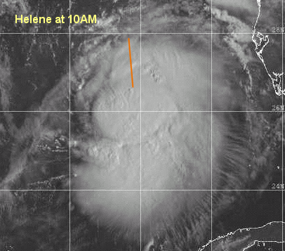
Hurricane Watches are up from Florida/Alabama Border to the mouth of the Alucilla River to the east. Helene has a chance of becoming a minimal hurricane before landfall. Right now the center is nearly exposed, so it's holding on. However, I still think it may strengthen. In any case, this is another big rain bringer. TD#13 hasn't strengthened any yet.

Busy again. Tropical Depression #13 forms in the east Atlantic.

It should track generally westward for the moment and eventually turn north. If in two days or so it doesn't turn north then a more westward track is possible.

Tropical Storm Helene has prompted Tropical Storm Warnings from the mouth of the Pearl River to the mouth of the Aucilla river. It could become a strong Tropical Storm before landfall, and a minimal hurricane is not out of the question either.

More to come later...

Helene

Comments or Questions? Everyone is invited to use it. Use the comment button by the story Headline.

Joseph Johnston's Mobile Alabama Webcam (Hosted on CFHC)

NRL Monterey Marine Meteorology Division Forecast Track of Active Systems (Good Forecast Track Graphic and Satellite Photos)
Map with nearly all model projected tracks plotted for Helene. And TD#13 From Michael Bryson.
Crown Weather Services Tropical Update (Includes Map with multiple forecast model tracks)
Snonut's Hurricane Reports
Satellite images at: [Visible] (visible -- Daytime Only) [Infrared] (infrared), and [Water Vapor] (water vapor)
Loops: Visible Loop - Infrared Loop - Water Vapor Loop
NASA GHCC Interactive Satellite images at:
[NAtl visible] (visible -- Daytime Only) [NAtl infrared] (infrared), and [NAtl water vapor] (water vapor)--Nasa source.
Ocean Surface Winds Derived from the SeaWinds Scatterometer (Experimental)
Tormenta.net Español -- Gran información sobre huracanes aquí.

Some Forecast models: (NGM, AVN, MRF, ECMWF, ETA)
DoD weather models (NOGAPS, AVN, MRF)
AVN, ECMWF, GFDL, NOGAPS, UKMET

- [mac]


Show All Comments | Show Previous 36 Comments

Displaying Talkbacks #19 - #39 (of 39 total)

Which means (#19)
Posted by: L.T. (
http://www.ssd.noaa.gov/SAB/TROP/DATA/img/GMEXIR4.html) Location: Pensacola, FL
Posted On 02:46PM 21-Sep-2000 with id (QURNQVSNQYWNRPV*)


The East side of the storm is strongest, its going in around Ft. Walton, FL. All the Models have it going in around there.

BTW (#20)
Posted by: StormHound (
http://www.stormhound.homestead.com) Location: O-Town
Posted On 02:58PM 21-Sep-2000 with id (QRNSUNQWNR*)


My thinking at this point is that Helene is already moving East of the forecast track. Unless this is a just a jog, I think we're looking at Helene making landfall significantly more East than the current forecast. I haven't been to keen on further strengthening, but she seems to still be gaining steam, so maybe a Cat 1 or 2 is possible.

East Side (#21)
Posted by:
Colleen Location: Lakeland, Florida
Posted On 03:01PM 21-Sep-2000 with id (RPUNQXXNQYYNRV*)


If the east side is the strongest, and the prediction of the llcc hitting Ft. Walton Beach, that puts an all out call to points further east for severe weather. Head up, Big Bend.

Helene (#22)
Posted by: Joe Location: St.petersburg
Posted On 03:10PM 21-Sep-2000 with id (RQVNSNQXRNQTS*)


I adgree Colleen the east side is the strongest.
I do think the big bend will have some of the
worst of it.I think the sould extend the watch's
or warnings further east.I do think the forecast
track should be moved further east.What do you
think

Helene (#23)
Posted by:
Bruce Location: Palm Bay Florida
Posted On 03:15PM 21-Sep-2000 with id (RPUNQXXNQYWNUV*)


Colleen, you are right, the strongest side will be the East side of the storm. I also feel that more of an eastward landfall will happen.

I Think ... (#24)
Posted by:
Colleen Location: Lakeland, Florida
Posted On 03:38PM 21-Sep-2000 with id (QURNQVSNQYUNRPV*)


but don't hold me to it, that the warnings *may* be extended further east; only because of the westerlies pushing the MLC more to to the east than the LLCC and because the strongest side is the eastern side. But, uh, then again...I am/probably/could be wrong. Look at the latest loops of Satellite images, and you can see what I mean. Anyway, no matter where she hits remember this: it is NOT the point of landfall, but the entire portion around it...this is a strong storm and a big storm.

UPDATED MODEL GUIDANCE GRAPHICS (#25)
Posted by:
Tony P. (http://€) Location: Panama City
Posted On 03:46PM 21-Sep-2000 with id (RPYNRQTNTVNQVW*)


New Guidance frm NHC as of 1 pm Central. BAMM takes storm to Miramar Beach, LBAR just west of Laguna Beach at Panama City Beach, and BAMD and A90E to Panama City. Check it out at www.hurricanealley.net/natl.htm, scroll down to TD12, click on tropical model graphics and for better close-up, tropical model graphics-zoomed. Site also has projected wind profiles for many locations in area but last update on that was 10:00am advisory. Can't wait til it's updated. Looks like I'm in for possible direct hit, whatever it ends up as.

Disclaimer (#26)
Posted by:
Colleen Location: Lakeland, Florida
Posted On 03:54PM 21-Sep-2000 with id (QURNQVSNQYUNRPV*)


To comment on my previous post about warnings being extended, please read the following disclaimer:

What I think should happen and what actually happens two totally different things.

After this season, I unexpect the expected...LOL!!!

Colleen

visible LLC (#27)
Posted by:
Frank Location: Biloxi MS
Posted On 03:59PM 21-Sep-2000 with id (QRNQSNRTXNS*)


Check out the vis sat loop at

http://kauai.nrlmry.navy.mil/sat-bin/tc_home

select animation and then select the past hour pixs from the menu and you can really start to see the LLC, which is pretty much exposed on the north, west and southwest sides at this time... still looks to be moving north with all the deep convection off to the east and southeast... I estimate the center to be at 27.4N and 87.2 W.... for this thing to get really cranked it needs to get the convection to start wrapping around the center... and this is not happening... could still be a nasty little TS though

helene meets the westerlies (#28)
Posted by: Frank Location: Tallahassee
Posted On 04:40PM 21-Sep-2000 with id (QRXNQXVNQRSNSW*)


my sentement is that helene gets nothing but downhill conditions from here on. the westerlies are already chewing away on the storm, and they ought to start nudging helene to the right. it should only be gale force winds and squalls, but the area from destin over to apalachicola look to get the greatest effect. helene should probably come ashore at status quo or weaker.. around daybreak tomorrow. like gordon did, i expect this one to stay inland and probably merge with the approaching front late tomorrow near columbus, ga.
thats what im going with. hope i get this one right *looks like a no brainer*.
lessee, cedar key got the last one, the panhandle gets this one.. their aim is off. still want my holiday. ya hear me hurricanes? the BIG BEND.
later folks.

Looks like.... (#29)
Posted by: L.T. (
http://www.ssd.noaa.gov/SAB/TROP/DATA/img/GMEXIR4.html) Location: Pensacola, FL
Posted On 04:42PM 21-Sep-2000 with id (RPUNQXXNRPPNST*)


Helene is expanding to the SW!!! This is weird!!!

helene-radar (#30)
Posted by:
Doug Location: sarasota
Posted On 04:44PM 21-Sep-2000 with id (RPTNQTTNQNTQ*)


Following the radar is not easy, but the last 1/2 hour seems to suggest to core of storm showing ne componet to it...can't actually see center, but can guess. I'm still guessing Apalacheecola eastward to Carrabelle.

Expanding? (#31)
Posted by: StormHound (
http://www.stormhound.homestead.com) Location: O-Town
Posted On 04:48PM 21-Sep-2000 with id (QRNSUNQWNR*)


Well, it doesn't really appear to be expanding to the SW, per se. I would say that currently the NE quadrant is weakening while the SW quadrant is strengthening. In general there is still a NNE movement which appears (to my eyes) to be slowing a bit. I would say this is probably temporary effect due to the ongoing shear Helene is experiencing. Remember this is not a strong storm, so she's more likely to be warped by her surroundings.

helene-visual sattelite (#32)
Posted by:
Doug Location: sarasota
Posted On 04:51PM 21-Sep-2000 with id (RPTNQTTNQNTQ*)


Addition to my last... reviewing the visual satellite reveals the llcc very clearly exposed, with convection east and ne of the circulation... not a healthy system.

slowing down? (#33)
Posted by:
Rick Shade Location: Mobile, Al
Posted On 05:00PM 21-Sep-2000 with id (RPYNQRNRSXNQSV*)


If in fact the system is slowing down..that usually means it is about to change directions...or even stall. They are notorious for that...If there are no strong steering currents...it could stall out there...and then as the easterlies die out...it could build. As well, the energy from the west...the low over there...may be merging...and either the system will become a blob of nothing...or they will converge. any idea of the true forward speed? Any chance the system could stall?

IMHO, (#34)
Posted by: Jim Mogle Location: Kissimmee
Posted On 05:31PM 21-Sep-2000 with id (RPUNRTRNRRXNSY*)


NHC is probably pretty accurate on this one. I don't think this system will give many surprises. Maybe a wobble here or there. Plus or minus 10 MPH on the winds. If the center continues to seperate, things could get a little more odd; but probably not.

Slowing (#35)
Posted by:
Steve H. Location: Palm Bay FL
Posted On 05:34PM 21-Sep-2000 with id (QURNQVSNRQSNQYV*)


Yes , on the latst loops it appears that Helene is slowing to a crawl. Her center is exposed and shear is a problem. If she stalls, she could get shredded, and eventually drift east-northeast. Her slowing could be an indication of the lack of steering and possibly a change of direction...hard to tell. With systems that approach the east coast of the US, when the forward speed slows it is generally a sign of a turn to the north, but in the Gulf..don't know. Do know if she sits she'll probably weaken rather than strengthen with persistent westerlies. We should know soon. Cheers!!

Center position (#36)
Posted by:
Frank Location: Biloxi MS
Posted On 06:25PM 21-Sep-2000 with id (QURNQVSNQYUNRPR*)


Looking at the latest NRL vis sat loop, I estimate the LLC to be at 27.88 N and 87.14 W, still moving to the north at about 12-13 mph. I don't see any stall based on the vis sat pix.. continues to move steadly to the north. However, the latest pix does suggest possibly an enlongation of the center from west to east.

Helene (#37)
Posted by:
Joseph Johnston Location: Mobile, AL
Posted On 06:32PM 21-Sep-2000 with id (RTNQXNRUNQPY*)


For any of you looking at the Mobile, Al. web cam, for some reason the T 1 line has gone out (wouldn't you know it?) We are trying to get it going. Just light rain and wind here.

Correction... (#38)
Posted by:
Frank Location: Biloxi MS
Posted On 06:33PM 21-Sep-2000 with id (QURNQVSNQYUNRPR*)


The center is not enlongating, just a lack a convection on the west side during a segment of a satellite loop.

Latest NRL vis sat loop indicated center at 27.95 N and 87.15 W. LLC easy to see and determine center.... system LLC is really exposed right now...

LLCC (#39)
Posted by:
Richard Byett (http://www.atlantic-technologies.co.uk) Location: Gloucester, England, UK
Posted On 06:43PM 21-Sep-2000 with id (RQRNQSYNQWTNQR*)


Although the LLCC is exposed it appears as if clouds are now beginning to try and build around the north and western side of it. What does anyone sle think?
Incidently i also think we will see a slightly east path compared to the nhc forecast, but i dont think they will be far wrong.


Show All Comments | Show Previous 36 Comments


Return to Central Florida Hurricane Center Main Page