MikeC
Admin
Reged:
Posts: 4544
Loc: Orlando, FL
|
|
2PM EDT 27 August 2022 Update
Three areas to watch this afternoon, one in the Caribbean, which has a 20% chance to develop probably mid week. The middle area, a complex wave system now has a 40% chance to develop within the next 5 days, and is the most likely place that will see a tropical storm or depression develop first of all the systems. And another wave currently exiting Africa with a 20% chance to develop.
The one east of the Caribbean islands is likely to gain the most attention over the next week, but those in the Yucatan Peninsula should watch out for the system in the Caribbean in case it gets going on Wednesday or so.
8AM EDT 27 August 2022 Update
The two areas in the Atlantic being watched still have the best chance to develop toward the middle of next week, with the Atlantic system more likely to. %30 chance for the Atlantic wave, which the islands will need to watch. The other area is 20% and will likely need to be watched for development around Wednesday.
He area in the Atlantic is a complex monsoonal type trough with a leading area of convection, this area is very large but currently trying to consolidate into one system. Chances for this system to develop in 5 days will likely increase by tomorrow or Monday, as this probably has the best chance to develop of any storm so far this month.
8AM EDT 26 August 2022 Update
The area and adjacent wave around 35W has a stronger sign of vorticity (turning) this morning, and some model support so this is probably the most likely area to form first over the next few days. This now has a 30% chance to develop over the next 5 days. The area now in the eastern Caribbean likely won't have a good chance to develop until mid next week, if at all, but both should be watched well into next week. This area still has a 20% chance for development over the next 5 days.
8AM EDT 25 August 2022 Update
There are two highlighted areas by the National Hurricane Center right now, neither are currently invest tagged, but the area to the west, near the Windward islands of the Caribbean has a 20% chance to develop over the next 5 days. If this were to develop, it would more likely be in central or Western Caribbean, possibly near Jamaica. It's close so important to watch, especially next week. The other area in the east Atlantic also has a 20% chance to develop.
4PM EDT 23 August 2022 Update
A new area to watch has formed off South America, southeast of the Windward islands of the Caribbean, with a 20% chance to develop over the next 5 days. This area will likely need to be watched very closely through next week. 90L has gone to 0% chance to develop over the next 5 days, but also should be watched longer range. Behind 90L is another area with a 20% chance for development.
8AM EDT 22 August 2022 Update
The unusually quiet August continues, but a system west of the Cabo/Cape Verde islands is being watched with a 20% chance for development. This system is worth keeping a watch on even if it does not develop east of the Caribbean as it could develop much later.
Beyond that another wave off Africa will be one to watch, and any areas coming off From South America also may have a very small chance to develop (particularly Thursday/Friday). This time of year you expand where you look to almost everywhere in the tropics.
11PM EDT 21 August 2022 Update
PTC4 made landfall in northern Mexico without developing into a depression or named storm.
9AM EDT 20 August 2022 Update
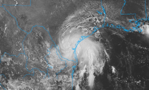
Potential Tropical Cyclone 4 in the bay of Campeche is still disorganzied this morning and has dropped to 60% chance for development before landfall. The tropical storm warnings remain up. Rainfall will be the story this coming week in Texas between it and a frontal system in the north.
Another area exiting Africa has a 20% chance to develop, and will likely be the first system of several to really watch coming off Africa this summer down the road.
5PM EDT 19 August 2022 Update
Potential Tropical Cyclone 4 is now being tracked in the bay of Campeche. Tropical Storm Warnings are up from Port Mansfield in Texas soutward to Baca De catan in Mexico. Landfall is in roughly 32 hours, and the current forecast peaks around 45mph winds. Rain combined with a front coming in will likely be the story the next week.
11:00AM EDT 19 August 2022 Update
99L is now up to a 60% chance for development with a special issued Tropical Weather Outlook:
Satellite imagery indicates that showers and thunderstorms associated with the broad low pressure area over the southwestern Gulf of Mexico and the Bay of Campeche are getting better organized.
Environmental conditions appear favorable for additional
development, and a tropical depression could form later today or on Saturday while the system moves northwestward across the southwestern and western Gulf of Mexico. However, by Saturday night, the system is expected to move inland over northeastern Mexico, which will end its chances of development. An Air Force
Reserve Hurricane Hunter aircraft is scheduled to investigate the system this afternoon. Interests along the northeastern coast of Mexico and the lower Texas coast should monitor the progress of this system. Regardless of development, this system could bring locally heavy rains to portions of northeastern Mexico and southern Texas over the weekend.
8:00AM EDT 19 August 2022 Update
The area in the Bay of Campeche (Southwest Gulf of Mexico) has a 40% chance to develop this morning, it's being tracked as Invest area 99L. This area is having a decent burst of convection over the bay this morning, which implies chances may go up later today. Based on where it's forming, landfall will likely be confined to Northern Mexico, but once there, however, a front approaching from the north combined with this system l may bring some needed rain to parts of Texas.
2:45PM EDT 18 August 2022 Update
The system near the Bay of Campeche is now being tracked as invest area 99L.
7:00AM EDT 18 August 2022 Update
The area currently over the Yucatan Peninsula of Mexico now has a 30% chance to develop. Convection is still fairly solid with this system over land, and when it moves into the Bay of Campeche in the Gulf, it has a small chance to reform and impact northern Mexico, and possibly extreme southern Texas. It won't have much time to organize, so it's likely going to just bring some rain. In combination with a front moving south, Texas may get a bit of rainfall relief this weekend.
Outside of this area nothing is expected to potentially develop in the next 5 days.
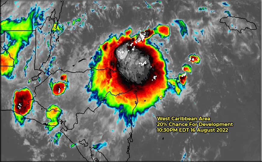
10:30PM EDT 16 August 2022 Update
The area in the west Caribbean having a decently large convection burst tonight, but proximity to land should keep it in check. This area currently still has a 20% chance for development over the next 5 days. The convection on satellite is mostly to the northeast of where the general center is thought to be.
1AM EDT 16 August 2022 Update
After 98L and with increasing model support and real-time observations that tropical activity is warming back up in the Atlantic, a little title update from "August So Far Mostly Quiet" to "August Revs Up."
For all practical intents and purposes, 98L became a Tropical Cyclone right about at landfall. This has been a very quirky season, challenging forecasters far more than usual in both the short and medium to long range, and it seems that a few more systems than usual may already be marked for post-season reanalysis. Never wise to let the "low numbers" of the season-to-date give too much solace in any year, and definitely now that conditions for development basin-wide appear to be swinging back to a non-hostile state.
For comps, as recently as August 16, 2019 there were only three Tropical Cyclones to this date: Andrea, Barry and TD3, and yet that year went on to produce a total of 20 T.C.s, 6 Hurricanes, 3 of which were Majors. So far in 2022 we are at three Named TCs: Alex, Bonnie & Colin. Plus, three non-official systems have been tracked that perhaps at a minimum one of which gets verified as a T.C. in the post-season reanalysis.
With 98L pushing further west into northern Mexico and southwest TX/southeast NM, our eyes are turning back to the western Caribbean and western Gulf of Mexico, where a convectively active tropical wave has a chance to develop, perhaps especially so if, as expected by , it crosses central America and enters the southwestern Gulf of Mexico by this weekend.
-Ciel
12PM EDT 14 August 2022 Update
Above: Invest 98L at 11AM CDT Aug. 14, 2022
Invest 98L has moved inland near Corpus Christi, TX this morning and is of a status that a more relaxed definition of Tropical Depression easily applies. Light to heavy rainfall is copious and there are also a few embedded thunderstorms. Maximum sustained winds so far appear to be under 35 MPH, with some gusts to Tropical Storm force along the coast and just out to sea. Perhaps another candidate for post-season review.
The tropical low is expected continue pushing through south Texas and eventually into Mexico, where a second intensification phase is possible in response to orographic forcing. Dangerous and potentially life-threatening flooding and mudslides may occur in parts of deep south Texas and in particular extreme northeastern Mexico should 98L move rather slowly, or even stall at some point in the next few days.
-Ciel
1PM EDT 12 August 2022 Update
The area of low pressure in the Gulf we have been monitoring for a few days continues to show signs of increasing organization. While official odds are low and global model guidance is wanting, this system now bears closer monitoring, and we have started a Lounge on this feature that will likely also be Invest tagged soon.
-Ciel
Gulf Low Lounge
8AM EDT 12 August 2022 Update
An area, surface trough, first really noticed yesterday in the Gulf off of the coast of Louisiana now has a 10% chance for development, mainly because the time it will have over water isn't extremely long and a frontal system typically takes a while to get going. However, it is likely to bring rain to parts of Texas later this weekend. It is currently not tagged as an invest area.
Original Update
With the exception of 97L which has a 30% chance for development, the first part of August has been fairly quiet. It's likely that in the latter half of August this will change, but things are trending toward a climatological average season this year. However, only takes one large one, and with a great deal of extremely warm water in the Western Atlantic, it's important to watch closer to home this year since things can change quickly.
97L is likely to hit shear this weekend which will keep it in check, but it is still worth watching beyond that to see where things go, and as the season peak starts toward the end of the month.
In general this site will be updated when things happen, and won't be when things are quiet.
|
MikeC
Admin
Reged:
Posts: 4544
Loc: Orlando, FL
|
|
With 97l out of the photo we have about 10-15 days before anything may get going, unless it's close to home. One area like this is currently off the Louisiana coastline which may try to get going, but likely won't have time to. may even put it in the at some point.
|
cieldumort
Moderator

Reged:
Posts: 2305
Loc: Austin, Tx
|
|
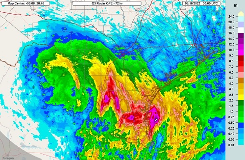
Some impressive 72-hr rainfall totals as of 8PM Aug 15 from 98L in S Texas. Far more beneficial than detrimental, given the serious drought conditions in the state.
|
MikeC
Admin
Reged:
Posts: 4544
Loc: Orlando, FL
|
|
Recon is scheduled tomorrow for the area over the Yucatan, which has healthy convection today even over the Yucatan Peninsula.
1. SUSPECT AREA (BAY OF CAMPECHE)
FLIGHT ONE - TEAL 71 FLIGHT - TEAL 72
A. 19/1800Z A. 20/1130Z,1730Z
B. AFXXX 01EEA INVEST B. AFXXX 0204A CYCLONE
C. 19/1515Z C. 20/0900Z
D. 20.0N 94.0W D. 22.0N 96.0W
E. 19/1730Z TO 19/2130Z E. 20/1100Z TO 20/1730Z
F. SFC TO 10,000 FT F. SFC TO 10,000 FT
G. LOW-LEVEL INVEST G. FIX
|
|


 Threaded


