danielw
Moderator

Reged: Wed
Posts: 3525
Loc: Hattiesburg,MS (31.3N 89.3W)
|
|
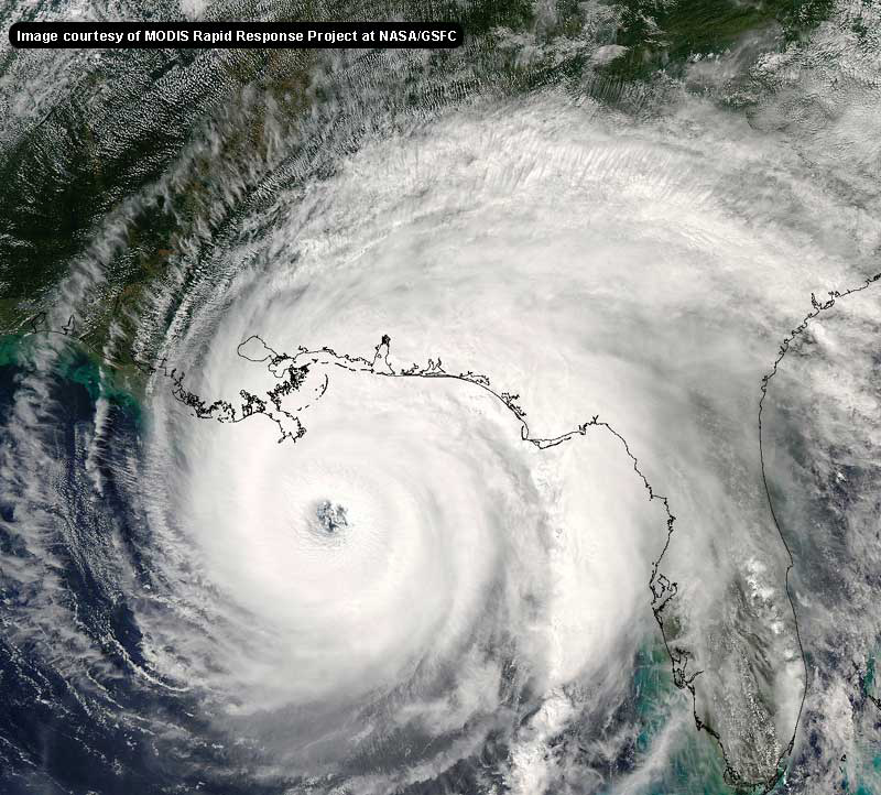
Here's the latest shot from GHCC, doesn't look like landfall-yet.
http://weather.msfc.nasa.gov/GOES/GOES03452004255wWvPQO.jpg
|
Justin in Miami
Storm Tracker
Reged: Thu
Posts: 269
Loc: Ft. Lauderdale, Florida
|
|
Frank P....I was thinking the same thing...maybe interaction with the mountains on the island? I have heard this can cause the eye to sort of rotate around them and resume course....hmm that's a question for the mets on this board...and btw...where are they? j/k I am sure they are very busy and in awe of what they are watching on sat loops.
|
BillD
User
Reged: Wed
Posts: 398
Loc: Miami
|
|
Bev, I agree, but I have to be careful what I say or some mod willl edit my post. So all I wll say is I agree. 
Bill
|
Fred08
Unregistered
|
|
anyone see the 48hr run..... looks to me to be further west and south than previous runs....hmmmm..
|
richiesurfs
Unregistered
|
|
Colleen...My post wasn't directed at you. Someone posted earlier that they saw Tom Terry say that He didn't exactly agree with the 's forecast track and that is what I was referencing. He;s entitled to his opinions but I still think he should not be undermining what the says... just my opinion.
|
Frank P
Veteran Storm Chaser
Reged: Mon
Posts: 1299
|
|
the last 1:45 minutes of IR loops shows on a basically west track, or perhaps just north of due west... since its so close to the island it is basically a worst case scenario set up... they are getting pounded with the ne quadrant, and even though the eye in not onland at the present time... its awful close to the island right now and I'm relatively sure parts of the eye wall is just playing havoc with poor Jamaica
|
SirCane
Storm Tracker

Reged: Tue
Posts: 249
Loc: Pensacola, FL
|
|
Ivan is moving West right now and even has had a slight WSW jog. The eye looks like it's going to miss the Jamaica coast for sure. I saw this happening early this afternoon.
I think is going to go between Pensacola and Panama City. The more it moves West like it does the farther West will hit in the U.S. 
|
Wxwatcher2
Storm Tracker

Reged: Tue
Posts: 337
Loc:
|
|
The local met here in orlando has said that will be a cat V until it landfalls Cooobah (cuba). Then down to a 4 and eventually a 3 near the fla panhandle if that track goes that way.
My question is after it enters the Fla Straits near Key West, what prevents it from going back to a Cat V?
Does it have anything to do with a Northward movement?
I've told family and friends today not to worry that it will not be a cat V byt the time it gets to central Florida but I just realized I don't know the reasoning behind it. I'm just repeating what the Mets said and what I've seen forecast.
|
RevUp
Weather Guru
Reged: Sun
Posts: 181
Loc:
|
|
As very fluid systems, hurricanes like to take the path of least resistance. You're right ... the topography is enough to steer to the left before it jumps north again, plus the upper level trofing to the north of Cuba may be helping to contain to the south on a more westward track. Amazing how accurate has been with this Jamaica forecast. It will be interesting to watch once it clears Jamaica!
--------------------
"Let tomorrow worry about itself. Each day has enough trouble of its own."
|
Colleen A.
Moderator

Reged: Sat
Posts: 1432
Loc: Florida
|
|
Tom Terry just said that it may be the strengthening of the storm that may spare Jamaica a direct landfall. However, if the hurricane force winds go out 60 miles, what's the difference between a direct landfall and a brush? Florida's looking at the same exact scenario.
Oh yeah...according to the latest update, they show crawling up along the west coast of Florida as a CAT 4 until it reaches the Panhandle...as a Cat 3. . A 30-mile jog to the east could be the difference between "bad" and "extremely bad". I don't know how big is, but I think everyone in Florida will feel the effects of , unless there is a major change in the track in the next 2 days.
Tom Terry just said that "for now we'll stick with 's forecast, the models are battling it out right now, we'll see what it brings in the next couple of hours."
I report, you decide. 
--------------------
You know you're a hurricane freak when you wake up in the morning and hit "REFRESH" on CFHC instead of the Snooze Button.
|
rule
Weather Guru
Reged: Thu
Posts: 132
Loc: Ocala, Florida
|
|
The eye looks to me about 30 miles offshore? Still, they are getting the NE component...
Signing off for tonight... will get up for 5 am update.. Just another day in Florida! 
|
SirCane
Storm Tracker

Reged: Tue
Posts: 249
Loc: Pensacola, FL
|
|
http://www.ssd.noaa.gov/PS/TROP/DATA/RT/float-vis-loop.html
Look at this. It wobbled WSW.
|
Rasvar
Weather Master

Reged: Fri
Posts: 571
Loc: Tallahassee, Fl
|
|
Oh my. They are actually giving DynaGel tv time. I don't even want to think about the tallk that will start.
|
WXMAN RICHIE
Weather Master

Reged: Mon
Posts: 463
Loc: Boynton Beach, FL
|
|
Email as of 11:30 pm:
The intense eyewall of CAT 5 is just south of the capital city of Kingston Jamaica at 11:15 pm EDT/0315 UTC. This is a catastrophic event we are watching and it will result in large loss of life. If you collect satellite images of tropical cyclones it's time to capture images of now because he is the perfect storm at the moment.
I forecast a landfall of a CAT 3 hurricane along the SW coast of Florida between Charlotte Harbor and Tampa Bay on Tuesday September 14, 2004, with a bulls eye on Siesta Key. Then we will see an inland track towards the NNE-NE possibly once again impacting the Orlando metro area. Statistically a second landfalling major tropical cyclone into Charlotte Harbor twice in one season is remote but the shallow estuary will be impacted in some negative way. A right turn into the SW coast due to speed divergence much like is probable with , but will move slower then . I forecast to be only a CAT 3 at landfall due to developing SW shear in the region.
By the way I can't ever remember a "major" hurricane landfalling in the big bend region of north Florida.
Take Care,
Thomas F. Giella
Retired Space & Atmospheric Weather Forecaster
Plant City, FL
--------------------
Another typical August:
Hurricane activity is increasing and the Red Sox are choking.
Live weather from my backyard:
http://www.wunderground.com/weatherstation/WXDailyHistory.asp?ID=KFLBOYNT4
|
WeatherNLU
Meteorologist

Reged: Sat
Posts: 212
Loc: New Orleans, LA
|
|
Quote:
http://www.ssd.noaa.gov/PS/TROP/DATA/RT/float-vis-loop.html
Surely a WSW jog. The center should have passed over eastern Jamaica with the trajectory it WAS on. It's now passing south.
Poor Jamaica, they have been embedded in the northern eyewall for 3 hours now.
Look at this. It wobbled WSW.
Edited by WeatherNLU (Sat Sep 11 2004 12:33 AM)
|
richiesurfs
Unregistered
|
|
one more thing...ifTom Terry didn't really say that then i'm all wrong about the whole thing. i respect him and really think he's good. of all the local stations i watch his is the one i choose over the others. that being said, i will still trust the over anyone else no matter how qualified they may be.
|
RevUp
Weather Guru
Reged: Sun
Posts: 181
Loc:
|
|
Quote:
My question is after it enters the Fla Straits near Key West, what prevents it from going back to a Cat V?
Does it have anything to do with a Northward movement?
This from the latest tropical weather discussion "... AN UPPER LOW NE OF THE BAHAMAS DRIFTING SW MAY IMPINGE UPON THE OUTFLOW DURING THE NEXT DAY OR SO. ... THE BIG FEATURE OVER THE SUBTROPICAL ATLC IS THE MID-OCEANIC UPPER TROUGH WHICH CONTINUES TO FRACTURE FORMING A VERY LARGE UPPER LOW NEAR 29N60W. THE UPPER LOW IS NOW RETROGRADING QUICKLY WESTWARD AND ERODING THE MID/UPPER LEVEL RIDGE WHICH HAS PERSISTED OVER THE W ATLC FOR SEVERAL DAYS. STRONG SUBSIDENCE AND DRY AIR WITH THE UPPER LOW IS SPREADING WESTWARD AND NOW COVERS A GOOD PORTION OF THE W ATLC TO THE SE UNITED STATES COAST."
In a word, "shear."
|
SirCane
Storm Tracker

Reged: Tue
Posts: 249
Loc: Pensacola, FL
|
|
I think has a better handle on than the others do.
This thing is moving due West right now.
|
mud1967
Weather Watcher
Reged: Tue
Posts: 42
Loc: Tallahassee, FL
|
|
Interesting and wonderful news that they are making evacuatiing more easy. So many don't leave because they know how bad it is to be stuck.
Tallahassee news 27 is going out on a limb and forcasting that they think it will be a US landfall. Now what's up with being so general that they can't even say it will be in Florida most likely. Maybe their thinking it will hit Minnesota.
|
Second Shift
Verified CFHC User
Reged: Sat
Posts: 14
Loc: Iowa
|
|
Colleen-I'm amazed at your knowledgel I just want to say Godspeed to those millions dealing with the Terrible. I have never seen a hurricane (much less a tornado). I cannot imagine what it would be like. We have plenty of room up here in Iowa for those who have had enough!
|
 Threaded


 [Re:
[Re: 


