Robert
Weather Analyst

Reged: Sat
Posts: 364
Loc: Southeast, FL
|
|
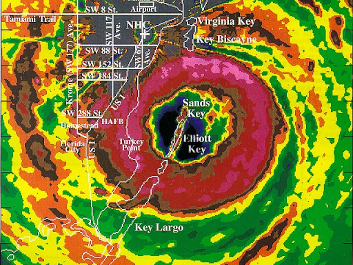
If you go to weather underground animated radar from key west you can see the annular eye in the center rotating around just packing the wall on the south side.
http://www.weatherunderground.com/radar/...mp;showlabels=1
|
pryord1
Weather Watcher
Reged: Sat
Posts: 49
Loc: Navarre, FL
|
|
He's only the mayor of the biggest party city in the USA. He certainly wasn't expecting to have to deal with a problem of this magnitude- not after so many "good" years of no tropical action for the NO area. He's running on pure adrenaline now with very little direction. This, of course, is only my opinion.
Boy, sat rad looks pretty healthy to me right now. A good-looking system (if you can call it that).
--------------------
The key to a good life is higher thought. Challenge yourself, push your personal limits and go for the brass ring!
|
orlandocanewatcher
Verified CFHC User
Reged: Thu
Posts: 16
Loc: E Central Florida
|
|
I agree Ralph, I live in Orlando and we just started getting some of the feeder bands and the wind is gusting here anywhere from 23-28mph.....
|
ralphfl
Weather Master
Reged: Mon
Posts: 435
|
|
Fox news just said its a cat 2 storm now.Guess they got a paid guy inside.
Love the guy they interviewed in key west.He basiclly told them its not coming here its going to texas or mexico.
Boy the news got off that fast something good they dont want to report.
Edited by ralphfl (Tue Sep 20 2005 01:23 PM)
|
Random Chaos
Weather Analyst

Reged: Sat
Posts: 1024
Loc: Maryland
|
|
Quote:
Fox news just said its a cat 2 storm now.Guess they got a paid guy inside.
No, it's official. 1:15pm update. Category 2.
http://www.nhc.noaa.gov/text/refresh/MIATCUAT3+shtml/201711.shtml
|
Psyber
Storm Tracker

Reged: Fri
Posts: 231
Loc: Ontario, Canada
|
|
Quote:
#3 they are talking right now about the models and all the talk is about it may go to N.O. they just said 3 good models show it going there.I cannot find 1 MIND YOU 1 that shows this storm going there.
God if they're forcasting on fox like that, CNN(which is wayyy more inflamitory than fox is) must be forcasting a N/E hit on NO.  Personally I think the jetstream would have to drop like 2000 miles and come up into the s-w of to give it enough power to make it go north enough to hit NO but thats just my wild forcasting. Personally I think the jetstream would have to drop like 2000 miles and come up into the s-w of to give it enough power to make it go north enough to hit NO but thats just my wild forcasting.
I think it's important that people realize that is going to build some in the next 2-3 days, that no matter where you are in the north part of the GOM, you are going to get a little bit of storm surge. The levees in NO are damaged and quite possibly cannot take even CAT1 storm surges without being broken in places which have not been shored up.
--------------------
The safest way to deal with a potential Hurricane hitting you...is to leave and just not be there at all.
|
Psyber
Storm Tracker

Reged: Fri
Posts: 231
Loc: Ontario, Canada
|
|
TS to CAT2 in under 3 hours...ouch. I have to say that thats a bit quicker than I thought it would. Just like someone flipped a switch as it passes the Florida straits. The water vapour loop just showed a fairly noticable increase. The eye hasn't even properly formed yet...this could really grow... 
--------------------
The safest way to deal with a potential Hurricane hitting you...is to leave and just not be there at all.
|
The Force 2005
Storm Tracker
Reged: Fri
Posts: 299
Loc: Philadelphia
|
|
Who are they that you are refering too?
|
The Force 2005
Storm Tracker
Reged: Fri
Posts: 299
Loc: Philadelphia
|
|
Katrina did exactly what has done. Explode rapidly.
Did it occur to anyone that has in it!!! HUMMMM
|
The Force 2005
Storm Tracker
Reged: Fri
Posts: 299
Loc: Philadelphia
|
|
The eye is increasing to develope a very well orginized wall feature. Ever present on SAT and RADAR.
Hold on to your hats, it's going to be wild for the next couple of days. I still think with all that is happening with the atmospheric conditions, that N.O should not let their guard down for any reason. Not to say will be on your doorstep, but to peek every so often through the window.
|
Thunderbird12
Meteorologist
Reged: Thu
Posts: 644
Loc: Oklahoma
|
|
The official intensity forecast has been bumped up to 95 knots (110 mph) in 6 hours and 105 knots (120 mph, cat 3) in 18 hours, then maintaining 105 knots until landfall.
Edited by Thunderbird12 (Tue Sep 20 2005 01:47 PM)
|
Psyber
Storm Tracker

Reged: Fri
Posts: 231
Loc: Ontario, Canada
|
|
Katrina took longer to build than has so far. If hadn't stalled and then gone N N/E like it did, it would have hit about where is heading except it wouldn't have been nearly as strong is is getting. took about a day longer to get to 100mph winds and was a day more west then is now.
--------------------
The safest way to deal with a potential Hurricane hitting you...is to leave and just not be there at all.
|
The Force 2005
Storm Tracker
Reged: Fri
Posts: 299
Loc: Philadelphia
|
|
MAXIMUM SUSTAINED WINDS HAVE REACHED 100 MPH...160 KM/HR...WITH HIGHER GUSTS. IS NOW A CATEGORY HURRICANE ON THE SAFFIR-SIMPSON SCALE. SOME STRENGTHENING IS FORECAST DURING THE
NEXT 24 HOURS.
HURRICANE FORCE WINDS EXTEND OUTWARD UP TO 30 MILES... 45 KM... FROM THE CENTER...AND TROPICAL STORM FORCE WINDS EXTEND OUTWARD UP TO 120 MILES...195 KM.
LATEST MINIMUM CENTRAL PRESSURE REPORTED BY A RECONNAISSANCE PLANE WAS 978 MB...28.88 INCHES
That is a huge drop in presure.
|
Rick on boat in Mobile
Weather Drama Guru

Reged: Wed
Posts: 161
|
|
they delayed a few hours or more before finally agreeing the hurricane was, in fact a hurricane. (from Joe Bastardi...it irritated him early this morning that they didn't consider it a hurricane....) that is why there is an "apparent explosion"....it is simply going through a normal escalation into a cat 4-5 hurricane....
remember
gulf of mexico.
high SST's....
New Orleans could get hit as easily as anyone else. the models have swung twice since I logged on this morning.
they will swing again...
if anyone thinks they are out of the woods...it is wishful thinking....
|
The Force 2005
Storm Tracker
Reged: Fri
Posts: 299
Loc: Philadelphia
|
|
Rick,
Joe was furious that the was not reporting the had reached CAT 1 by the 8AM advisory, but they were going on what the RECON was delivering. Now, we see the onslaught taken place, and agree with you, with an intense and strengthening hurricane, she will eventually make her her own winds to steer as well, so that is something the models have to take into an account.
Edited by The Force 2005 (Tue Sep 20 2005 01:52 PM)
|
Jeffmidtown
Weather Guru

Reged: Wed
Posts: 132
Loc: Atlanta, Ga
|
|
Steve Lyons on just said that they found a central pressure of 976mb in .....(sheesh, she's not a lovely meter maid is she? Beatles song...)
Also on the Drudge Report it has Number Nine as the headline, would this be the 9th storm to hit the US or the Ninth Hurricane to form?
|
Bloodstar
Moderator

Reged: Mon
Posts: 462
Loc: Tucson, AZ
|
|
I hesitate to call it exploding... it's intensifying, but... what i think you're seeing is a system that was poised to strengthen, being held back by the interaction with the bahamas. It's free of that influence, and now it's simply gotten to the strength it probably woud have been without land interaction. (In otherwords, the disruption of the inner core has lessened, so the system is able to take better advantage of the positive environment.
Now, if they find it a cat 3 by 11pm, I might be more willing to say it's exploding 
I know just happened, but can we avoid -like Comparisons for now? Just like Camille, I think should be the flhurricane equivalent of invoking "Godwin's Law" 
-Mark
--------------------
M. S. Earth and Atmospheric Sciences, Georgia Tech - May 2020
Brookhaven National Laboratory
U. Arizona PhD Student
|
FlaMommy
Storm Tracker

Reged: Fri
Posts: 225
Loc: Tampa(Riverview), Florida
|
|
well here in Riverview we just got lil taste of ....we had some heavy rain and 30 mph gusts....enough to wake up my 2 yr old from a nap...anyone think we will get anything more than just those type of conditions in the Tampa area?...
hope no one took this lightly in the keys....stay safe
--------------------
"Haven't thought of a witty one lately"
|
lunkerhunter
Storm Tracker

Reged: Fri
Posts: 248
Loc: Saint Augustine, FL
|
|
Rick,
Gulf SST's are lower than with although they are still warm. Florida Bay is very warm and is fueling this burst.
now
then
|
Psyber
Storm Tracker

Reged: Fri
Posts: 231
Loc: Ontario, Canada
|
|
Flamommy,
there's nothing that shows doing anything other than heading out into the GOM.(away from Tampa).
--------------------
The safest way to deal with a potential Hurricane hitting you...is to leave and just not be there at all.
|
 Threaded


 [Re:
[Re: 


 Personally I think the jetstream would have to drop like 2000 miles and come up into the s-w of


