MikeC
Admin
Reged: Sun
Posts: 4543
Loc: Orlando, FL
|
|
Also the far western edge of Irene is just now coming into the long range radar range of Miami.
|
JMII
Weather Master

Reged: Thu
Posts: 489
Loc: Margate, Florida
|
|
The Wunder Maps provided by Weather Underground are an excellent way to track these small wobbles as those maps allow you to overlay the satellite data on top of a Google Map view with forecast positions shown. The only thing missing are LAT / LON lines for reference but with the position markers you can see if Irene is on target or not.
41 mph gust at George Town, Bahamas where the pressure is 29.46 and dropping fast with Irene now 80 miles away. This location is just on the outside the "red" on Rainbow IR image indicating the core of the storm. Its always amazing to see how closely the wind speeds follow the pressure as a hurricane approaches.
While a Cat 3 Irene still has a small wind field. Hurricane force winds only extending out 50 miles. Compare this with (also Cat 3) at landfall in SW FL which had a 90 mile radius of hurricane force winds. At that point 's wind field basically covered the southern half of FL from the Big O to the upper keys (all of Dade, Broward and Palm Beach County) with 75 mph + winds.
--------------------
South FL Native... experienced many tropical systems, put up the panels for:
David 79 - Floyd 87 - Andrew 92 - Georges 98 - Frances 04 - Wilma 05 - Matthew 16 - Irma 17
Lost our St James City rental property to Ian 22
|
Random Chaos
Weather Analyst

Reged: Sat
Posts: 1024
Loc: Maryland
|
|
And here is our beauty:
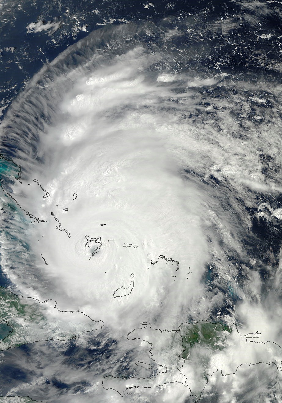
Uncropped (1km resolution):
http://lance-modis.eosdis.nasa.gov/cgi-bin/imagery/single.cgi?image=Irene.A2011236.1505.1km.jpg
Larger (500m resolution):
http://lance-modis.eosdis.nasa.gov/cgi-bin/imagery/single.cgi?image=Irene.A2011236.1505.500m.jpg
Much larger (250m resolution):
http://lance-modis.eosdis.nasa.gov/cgi-bin/imagery/single.cgi?image=Irene.A2011236.1505.250m.jpg
|
StrmTrckrMiami
Weather Guru

Reged: Mon
Posts: 148
Loc: Manchester, NH
|
|
I've noticed that they did make a few changes.
Originally the track had Maine in the "H" reading meaning it would be a cat 1 hurricane when she hit their area. Now it only has Mass and the lower portion of NH in the "H" reading, and Maine is a TS Status. Any clue on what New England should expect for this? I think a major concern here would be flooding, and worry a repeat of the 2006 floods may occur.
--------------------
Tracking Storms Since 2004
Miami, Cocoa, Fort Myers and Jacksonville
Currently Reside in New England
|
ralphfl
Weather Master
Reged: Mon
Posts: 435
|
|
someone asked for this site http://moe.met.fsu.edu/tcgengifs/
|
Random Chaos
Weather Analyst
Reged: Sat
Posts: 1024
Loc: Maryland
|
|
That change in Maine probably has more to do with the points being 24 hour points but only 6 hours having passed since the last graphic, than any change in intensity.
|
StrmTrckrMiami
Weather Guru
Reged: Mon
Posts: 148
Loc: Manchester, NH
|
|
Quote:
That change in Maine probably has more to do with the points being 24 hour points but only 6 hours having passed since the last graphic, than any change in intensity.
Makes Sense. Thank you.
--------------------
Tracking Storms Since 2004
Miami, Cocoa, Fort Myers and Jacksonville
Currently Reside in New England
|
vineyardsaker
Weather Guru

Reged: Wed
Posts: 150
Loc: New Smyrna Beach, FL
|
|
Quote:
And here is our beauty:
Uncropped (1km resolution):
http://lance-modis.eosdis.nasa.gov/cgi-bin/imagery/single.cgi?image=Irene.A2011236.1505.1km.jpg
Larger (500m resolution):
http://lance-modis.eosdis.nasa.gov/cgi-bin/imagery/single.cgi?image=Irene.A2011236.1505.500m.jpg
Much larger (250m resolution):
http://lance-modis.eosdis.nasa.gov/cgi-bin/imagery/single.cgi?image=Irene.A2011236.1505.250m.jpg
Thank you so much for the links to these absolutely stunning and beautiful pics!
--------------------
Charley(eyewall), Ivan, Jeanne, Dennis, Wilma, Irma, Ian (eyewall), Nicole
|
cieldumort
Moderator

Reged: Mon
Posts: 2305
Loc: Austin, Tx
|
|
Quote:
Originally the track had Maine in the "H" reading meaning it would be a cat 1 hurricane when she hit their area. Now it only has Mass and the lower portion of NH in the "H" reading, and Maine is a TS Status. Any clue on what New England should expect for this? I think a major concern here would be flooding, and worry a repeat of the 2006 floods may occur.
There are two primary reasons for the change from "H" to "S" over Maine, as follows:
First, the estimated location of the center of Irene during the final period of the 5-Day Cone of Uncertainty from Advisory 18 is now further inland than shown in Advisory 17A , and as such, Irene will have had more time inland weakening, essentially as Random C mentioned above. You can run a historic loop of the graphic Advisories here: http://www.nhc.noaa.gov/archive/2011/graphics/al09/loop_5W.shtml
Second, and related to the first reason, Irene is officially forecast to have turned post-tropical by 2PM Monday. However, it is worth noting that this forecast is largely dependent on Irene being well inland at that time. Should Irene still be partly, largely, or fully over water, it is very possible that she would be more tropical than not, and as such, may still be a hurricane as of Monday afternoon.
As to what New England should expect, it is too early to tell for sure. Tropical Cyclone forecasts beyond 3 days are notoriously off by up to several hundred miles. As during all seasons, it is best to prepare for the worst and expect the best. Irene has the potential to be an epic east coast storm. Potential.
|
Random Chaos
Weather Analyst
Reged: Sat
Posts: 1024
Loc: Maryland
|
|
Anyone know what is up with the NOAA2 recon? It was heading into the storm when it turned around, and is now back over Florida heading in the general direction of where it took off from.
We still have Air Force AF302 heading in from the east though.
OT: Energy propagation of yesterday's earthquake (click play on the animation)
|
MikeC
Admin
Reged: Sun
Posts: 4543
Loc: Orlando, FL
|
|
That usually means mechanical or met equpiment problems, especially with the NOAA planes. But it could be anything really.
Added another satellite recording of Irene. I may record Radar if more gets into view later.
|
WesnWylie
Weather Guru
Reged: Sat
Posts: 155
Loc:
|
|
Latest Air Force Recon data is showing that Irene's pressure has dropped to 949.9 mb. I have noticed that Irene's well-defined eye has been slowly fading on satellite. I wonder if she is going to go through another intensification period this evening.
--------------------
2011 Season Forecast: 16/09/04
2011 Systems: 10/01/01
Edited by WesnWylie (Wed Aug 24 2011 08:04 PM)
|
StrmTrckrMiami
Weather Guru
Reged: Mon
Posts: 148
Loc: Manchester, NH
|
|
Quote:
Latest Air Force Recon data is showing that Irene's pressure has dropped to 949.9 mb. I have noticed that Irene's well-defined eye has been slowly fading on satellite. I wonder if she is going to go through another intensification period this evening.
I had a link somewhere but can not find the Recon data/stats anywhere... do you have a link?
--------------------
Tracking Storms Since 2004
Miami, Cocoa, Fort Myers and Jacksonville
Currently Reside in New England
|
cguhr3
Registered User
Reged: Wed
Posts: 5
Loc: Cape May, NJ 08204
|
|
Looking at a single source .. unysis... a jog to the west is possible @ mid atlantic region... your thoughts?
|
MikeC
Admin
Reged: Sun
Posts: 4543
Loc: Orlando, FL
|
|
I assume the European (EMCWF) model, that clips North Carolina bends back Irene westward and takes Irene through Delmarva, and up near Wildwood, NJ. That is a change from earlier runs (a bit to the west), which implies more threat to the Northeast. I do know that the NWS is expanding the release of weather balloons westward to help determine the strength of the trough in ridge in the northeast that may kick the system back west when it gets north of North Carolina.
Those in the Outer Banks of North Carolina, Hampton Roads/Virginia Beach, VA, Delmarva, Jersey Shore, NYC, Long Island, RI, MA, NH, and Maine will want to watch Irene Closely.
It's still too early to say that far away. I will say... watch the 's 11PM track tonight.
I fixed the link to the Abaco Rocky Bay cam on the front page, and also the RSS storm feed.
|
DougBaker
Verified CFHC User
Reged: Fri
Posts: 18
|
|
The 2nd fleet at Norfolk, va is preparing to leave in advance of Irene
http://www.digtriad.com/news/national/ar...Are-Set-To-Move
|
watchinout
Verified CFHC User
Reged: Sat
Posts: 17
|
|
Just noticed that as of the 8pm update the potential track stated by BAMS has shifted farther west, nearly brings the storm into cape canaveral before turning sharp east and heading for open water. Now I know that every other model is saying its not going to come this close to FL but if you look at the past track of Irene the BAMS has been the most consistent for atleast 2/3's of the past track. What is everyones thoughts?
|
cguhr3
Registered User
Reged: Wed
Posts: 5
Loc: Cape May, NJ 08204
|
|
thank you... will keep watching!
|
GuppieGrouper
Weather Master
Reged: Fri
Posts: 596
Loc: Polk County, Florida
|
|
Quote:
Just noticed that as of the 8pm update the potential track stated by BAMS has shifted farther west, nearly brings the storm into cape canaveral before turning sharp east and heading for open water. Now I know that every other model is saying its not going to come this close to FL but if you look at the past track of Irene the BAMS has been the most consistent for atleast 2/3's of the past track. What is everyones thoughts?
I will refer you to Ed 's blog on the front page right hand side of screen. He lays out the positions and forecasts. Anything could happen but, the knows its business well enough to keep us informed for up to 3 days in advance of a landfall. I refer you to the forecasting lounge to discuss alternate theories regarding movements of the storm.
--------------------
God commands. Laymen guess. Scientists record.
|
MikeC
Admin
Reged: Sun
Posts: 4543
Loc: Orlando, FL
|
|
Quote:
Just noticed that as of the 8pm update the potential track stated by BAMS has shifted farther west, nearly brings the storm into cape canaveral before turning sharp east and heading for open water. Now I know that every other model is saying its not going to come this close to FL but if you look at the past track of Irene the BAMS has been the most consistent for atleast 2/3's of the past track. What is everyones thoughts?
Model discussion really belongs in the forecast lounge, but the BAMM has actually done horrible with Irene (see the history animatios). It tends to do better with weak near systems and not hurricanes. It can be fairly safely be ruled out.
|
 Threaded

 [Re:
[Re: 


