Original Entry
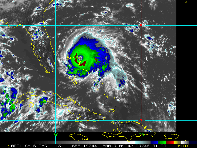
We are just a few weeks away from the climatological peak of the Atlantic Hurricane Season, and there are several systems we are monitoring, three of which are close to or closing in on land: 98L, 99L, W Gulf Low (Very strong 90L candidate).
As these systems are all tending to form in the Western Atlantic, as has been a trend this year, they are far more likely to affect land or interests close to land, including the south and/or southeast U.S.
As of 5PM EDT today August 23, official odds for development are as follows: 98L 90%, 99L 50% (could be conservative), Gulf Low: TBD. Was still under 10% at the 2PM and thus not listed at that time, but this system has continued to impress, with surface pressures falling some and winds increasing some throughout the day today.
Follow along with us in the 2019 Forecast Lounge , as well as here on the Homepage.
Links to individual Forecast Lounges:
Invest 98L Lounge, Tropical Storm Dorian Lounge, W Gulf Low _90L_ Lounge
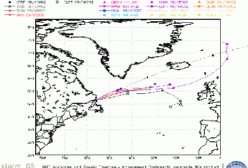
Dorian Event Related Links
SFWMD Model Plot (Animated Model Plot) SFWMD Hurricane Page
[https://flhurricane.com/floatanimator.php?year=2019&storm=5 Flhurricane Satellite Floater Animation of Dorian
GOES Floater
Animated Model Plot of Dorian
Clark Evans Track Model Plot of Dorian
(Animated!) Model Plots in Google Earth - In Google Maps
Clark Evans Intensity Model Plot of Dorian (Animated!)
Clark Evans Track Plot of Dorian
Other Model Charts from Clark
Clark Evans Top 10 Analog Storms for Dorian
More model runs on from RAL/Jonathan Vigh's page
NRL Info on Dorian -- RAMMB Info
COD Atlantic Satellite View
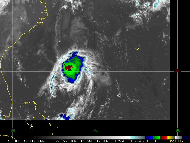
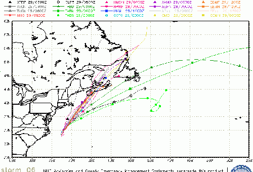
Invest 98L Event Related Links
SFWMD Model Plot (Animated Model Plot) SFWMD Hurricane Page
[https://flhurricane.com/floatanimator.php?year=2019&storm=6 Flhurricane Satellite Floater Animation of 98L
GOES Floater
Animated Model Plot of 98L
Clark Evans Track Model Plot of 98L
(Animated!) Model Plots in Google Earth - In Google Maps
Clark Evans Intensity Model Plot of 98L (Animated!)
Clark Evans Track Plot of 98L
Other Model Charts from Clark
Clark Evans Top 10 Analog Storms for 98L
More model runs on from RAL/Jonathan Vigh's page
NRL Info on 98L -- RAMMB Info
COD Atlantic Satellite View
StormCarib Reports from the Caribbean Islands
Caribbean Weather Observations
Barbados Brohav Weather Fax
Full Caribbean Radar Composite
Caribbean Broadcast Corporation (TV/Radio from Antilles)
San Juan, PR NWS Page
Various Caribbean Radio Stations
DR1 Dominican Republic Hurricanes
East Florida Links
Southeast Composite Radar Loop
(Latest Static)
South to North:
Key West, FL Radar Radar Loop
(Latest Static)
Miami, FL Radar Radar Loop
(Latest Static)
Melbourne, FL Radar Radar Loop
(Latest Static)
Jacksonville, FL Radar Radar Loop
(Latest Static)
Caribbean/South East Coast Satellite Imagery
SFWMD Radar Loop of South Florida with storm Track
SFWMD Full Florida Radar Loop with Storm Track
Area Forecast Discussions:
FLorida Keys -
Miami/South Florida -
Melbourne/East Central Florida -
Jacksonville/Northeast Florida -
Invest 98L Lounge Invest 99L Lounge W Gulf Trof Lounge
North Gulf Links
North Gulf/Southern Mississippi Valley Composite Radar Loop
(Latest Static)
East to West:
Mobile, AL Radar Radar Loop
(Latest Static)
New Orleans, LA Radar Radar Loop
(Latest Static)
Lake Charles, LA Radar Radar Loop
(Latest Static)
Houston/Galveston, TX Radar Radar Loop
(Latest Static)
Gulf of Mexico Satellite Imagery
Area Forecast Discussions:
Mississippi/Alabama/Pensacola -
New Orleans, LA -
Lake Charles, LA -
Houston/Galveston, TX
Edited by MikeC (Sun Aug 25 2019 06:31 AM)
 Threaded


