Update 2PM CDT Oct 25, 2019
Recon is presently in SEVENTEEN and finding winds well within tropical storm force. In addition, there are structural clues as well as conditions over the gulf with the front suggesting that it may remain predominantly a tropical cyclone for longer than originally expected. Louisianans and those in the north-central Gulf may want to begin paying this storm much more attention.
Invest 98L to the southwest of the Azores may become a Vince-like hurricane and is also likely to be named at any time.
Original Update
2019 continues to be active, with newly formed TD 17 in the northern Gulf - and quite possibly already a tropical storm pending better confirmation - plus, formerly non-tropical Invest 98L in the northern Atlantic a few hundred miles southwest of the western Azores, which could also get a name at any time. The next two names on the list this year in the Atlantic are Olga and Pablo.
This season has already tied 2005 for 'the most named storms lasting one day or less on record' (Philip Klotzbach), and depending on what happens with SEVENTEEN (or any others perhaps still yet to come), could become the new record holder of one-day-or-less-named storms.
Forecast Lounges: Olga Lounge, Pablo Lounge
OLGA Event Related Links


SFWMD Model Plot (Animated Model Plot) SFWMD Hurricane Page
[https://flhurricane.com/floatanimator.php?year=2019&storm=Olga Flhurricane Satellite Floater Animation of 17L
GOES Floater
Animated Model Plot of 17L
Clark Evans Track Model Plot of 17L
(Animated!) Model Plots in Google Earth - In Google Maps
Clark Evans Intensity Model Plot of 17L (Animated!)
Clark Evans Track Plot of 17L
Other Model Charts from Clark
Clark Evans Top 10 Analog Storms for 17L
More model runs on from RAL/Jonathan Vigh's page
NRL Info on 17L -- RAMMB Info
COD Atlantic Satellite View
PABLO Event Related Links


SFWMD Model Plot (Animated Model Plot) SFWMD Hurricane Page
[https://flhurricane.com/floatanimator.php?year=2019&storm=Pablo Flhurricane Satellite Floater Animation of 18L
GOES Floater
Animated Model Plot of 18L
Clark Evans Track Model Plot of 18L
(Animated!) Model Plots in Google Earth - In Google Maps
Clark Evans Intensity Model Plot of 18L (Animated!)
Clark Evans Track Plot of 18L
Other Model Charts from Clark
Clark Evans Top 10 Analog Storms for 18L
More model runs on from RAL/Jonathan Vigh's page
NRL Info on 18L -- RAMMB Info
COD Atlantic Satellite View
North Gulf Links
North Gulf/Southern Mississippi Valley Composite Radar Loop
(Latest Static)
East to West:
Mobile, AL Radar Radar Loop
(Latest Static)
New Orleans, LA Radar Radar Loop
(Latest Static)
Lake Charles, LA Radar Radar Loop
(Latest Static)
Houston/Galveston, TX Radar Radar Loop
(Latest Static)
Gulf of Mexico Satellite Imagery
Area Forecast Discussions:
Mississippi/Alabama/Pensacola -
New Orleans, LA -
Lake Charles, LA -
Houston/Galveston, TX
Sebastien Event Related Links
SFWMD Model Plot (Animated Model Plot) SFWMD Hurricane Page
[https://flhurricane.com/floatanimator.php?year=2019&storm=20 Flhurricane Satellite Floater Animation of Sebastien
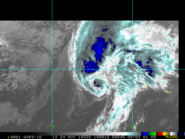
GOES Floater
Animated Model Plot of Sebastien
Clark Evans Track Model Plot of Sebastien
(Animated!) Model Plots in Google Earth - In Google Maps
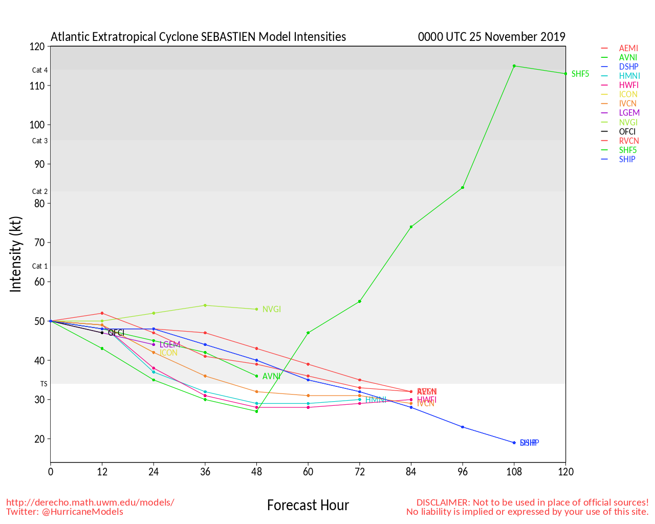
Clark Evans Intensity Model Plot of Sebastien (Animated!)
Clark Evans Track Plot of Sebastien
Other Model Charts from Clark
Clark Evans Top 10 Analog Storms for Sebastien
More model runs on from RAL/Jonathan Vigh's page
NRL Info on Sebastien -- RAMMB Info
COD Atlantic Satellite View
Edited by MikeC (Tue Nov 19 2019 01:13 PM)
 Threaded


