7:00AM CDT Update 25 July 2020
Hanna found to be a hurricane by recon this morning, landfall likely between Corpus Cristi and Brownsville.
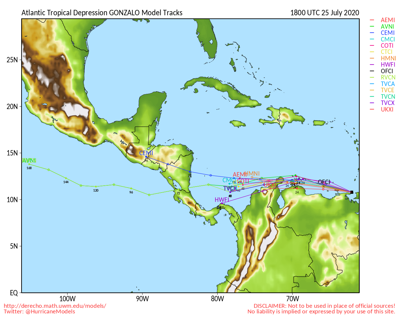
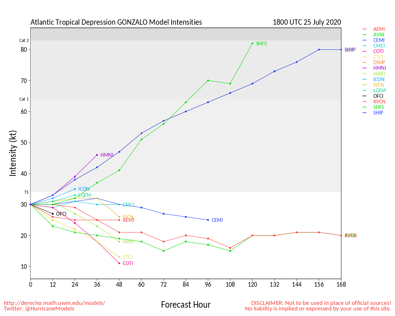
Gonzalo still remains very weak.
92L is up to a 60% chance to develop over the next 5 days.]
In Hawaii, Douglas has raised Hurricane watches for the Big Island, Maui, and Oahu.
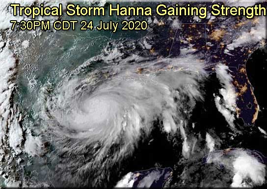
10:00PM CDT Update 24 July 2020
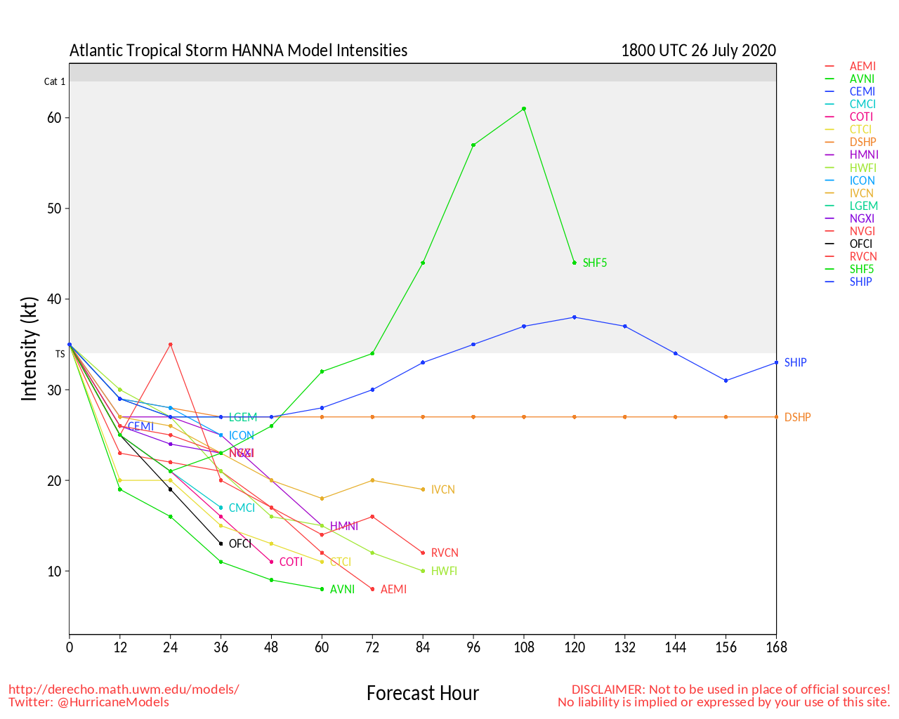
Tropical Storm Hanna has strengthened to a 65mph Tropical storm tonight, it's likely to become a hurricane sometime tomorrow morning. Although the forecasts a 75 mph hurricane, they note that the peak intensity could be higher than what is
shown since landfall is expected to occur between the 12 and 24 hour forecast times.
Because of this and the slight shift south in position, the Hurricane Warning has been extended southward to Port Mansfield Texas. The Tropical Storm Warning has been extended northward to High Island Texas. The government of Mexico has issued a Tropical Storm Warning north of Barra el Mezquital to the Mouth of Rio Grande.
Those in Texas should prepare for a potent hurricane with serious flooding risks as best they can since this increased more rapidly that originally forecast. Pay attention to local media and officials for the best information for your particular area.
9:00PM CDT Update 24 July 2020
Hanna may be close to becoming a hurricane tonight. Important updates are likely coming soon from . The prospect that Hanna comes in significantly stronger than forecast is now a distinct possibility. One can also follow along with additional information and model talk in the Hanna Forecast Lounge
Ciel
4:30PM CDT Update 24 July 2020
Hanna is now forecast to be a Hurricane at landfall, and Hurricane and Storm Surge Warnings have been issued for portions of the south Texas Coast. With the core appearing better on radar. If you are in the warning area, please be mindful of local media and officials.
A Hurricane Warning has been issued from Baffin Bay northward to Mesquite Bay, Texas.
A Storm Surge Warning has been issued from Baffin Bay to Sargent, Texas, including Corpus Christi Bay, Copano Bay, Aransas Bay, San Antonio Bay and Matagorda Bay.
11AM Update 22 July 2020
SEVEN is rapidly organizing and has become the earliest seventh named storm in the Atlantic on record, besting even 2005's Gert by two days. Gonzalo is a small, compact and well organized system, and as such, may continue to intensify counter to the global models, which all but missed this cyclone entirely. In fact, now calls for further strengthening and for the cyclone to become a hurricane prior to reaching the Windward Islands.
Elsewhere, recon will be flying Invest 91L in the Gulf of Mexico today, which should help with its forecast. As it stands, the disturbance has about even odds of becoming a named storm prior to impacting the western Gulf. Interests especially from Louisiana to Texas may want to pay close attention to this one, as it could be a prolific rain/flood maker.
Ciel
5PM Update 21 July 2020
Invest 99L is now Tropical Depression Seven, it is forecast to remain below hurricane strength, however it's small size means it could rapidly strengthen or weaken over the next few days, so those in the Windwards should keep watch on it.
91L remains in the Gulf, and has a better shot on Thursday to develop, but still remains relatively low. Another wave east of TD#7 will be the next thing to watch, and also a very small area north of Puerto Rico.
Original Update
The system east of the Windward islands of the Caribbean (99L) is now up to an 80% chance for development, and is very likely to become a storm or depression later today. Conditions become much less favorable this weekend, but in the meantime those in the Eastern Caribbean should keep watch. The next name on the list is Gonzalo.
The system has a relatively small size, and that seems to be working in its favor. Dry air nearby would likely weaken it otherwise. Shear later may be what weakens it this weekend, and the small size works against it there.
The other area near Cuba (91L) still has a 40% chance for development and is not currently being tracked as an Invest.
Recon was tentatively scheduled to check the area out later today, but was since cancelled. Those in the northwest gulf should keep watch on this one, as we could have two active tropical systems later this week.
Conditions aren't great for the Cuba system right now, but it is likely that this improves around Thursday.
StormCarib Reports from the Caribbean Islands
Caribbean Weather Observations
Barbados Brohav Weather Fax
Full Caribbean Radar Composite
Caribbean Broadcast Corporation (TV/Radio from Antilles)
San Juan, PR NWS Page
Various Caribbean Radio Stations
DR1 Dominican Republic Hurricanes
Tropical Storm Gonzalo Event Related Links

SFWMD Model Plot (Animated Model Plot) SFWMD Hurricane Page
[https://flhurricane.com/floatanimator.php?year=2020&storm=7 Flhurricane Satellite Floater Animation of Gonzalo
GOES Floater
Animated Model Plot of Gonzalo
Clark Evans Track Model Plot of Gonzalo
(Animated!) Model Plots in Google Earth - In Google Maps
Clark Evans Intensity Model Plot of Gonzalo (Animated!)
Clark Evans Track Plot of Gonzalo
Other Model Charts from Clark
Clark Evans Top 10 Analog Storms for Gonzalo
More model runs on from RAL/Jonathan Vigh's page
NRL Info on Gonzalo -- RAMMB Info
COD Atlantic Satellite View
Forecast Lounge and Model Talk on Tropical Storm Gonzalo
Hanna Event Related Links

SFWMD Model Plot (Animated Model Plot) SFWMD Hurricane Page
[https://flhurricane.com/floatanimator.php?year=2020&storm=8 Flhurricane Satellite Floater Animation of Hanna
GOES Floater
Animated Model Plot of Hanna
Clark Evans Track Model Plot of Hanna
(Animated!) Model Plots in Google Earth - In Google Maps
Clark Evans Intensity Model Plot of Hanna (Animated!)
Clark Evans Track Plot of Hanna
Other Model Charts from Clark
Clark Evans Top 10 Analog Storms for Hanna
More model runs on from RAL/Jonathan Vigh's page
NRL Info on Hanna -- RAMMB Info
COD Atlantic Satellite View
Forecast Lounge and Model Talk on Hanna in the Gulf of Mexico
Galveston Live Beach Cam
Flhurricane recordings of landfall area radar and webcams
Texas Gulf Coast Links
[http://moe.met.fsu.edu/~mnissenbaum/radar.html Mark Nissenbaum's radar page}
East to West:
Houston/Galveston, TX Radar Radar Loop
(Latest Static)
Corpus Christi, TX Radar Radar Loop
(Latest Static)
Brownsville, TX Radar Radar Loop
(Latest Static)
Gulf of Mexico Satellite Imagery
Area Forecast Discussions:
Houston/Galveston, TX
- Corpus Christi, TX - Browsnville/South Padre Island, TX
Douglas/Hawaii Approach info
Central Pacific Hurricane Center
Radar:
South Shore Big Island, HI Radar Radar Loop
(Latest Static)
Kohala, HI (Big Island) Radar Radar Loop
(Latest Static)
Molokai, HI (Maui/Oahu) Radar Radar Loop
(Latest Static)
Kauai, HI Radar Radar Loop
(Latest Static)
River/Stream Gauges in Hawaii
Hawaii Power Outage Map
Hawaiian Media:
TV:
KITV 4 - Honolulu (ABC)
KHON 2 - Honolulu (Fox)
Hawaii News Now KGMB 9 (CBS)/KHNL 13 (NBC)
Newspaper:
Hawaii 24/7 (Big Island Newspaper)
Hawaii Tribune-Herald
Maui News
Honolulu Star Advertiser
Other:
Big Island News Now
Hawaii Tracker Big Island News
Invest 92L (East Atlantic) Event Related Links

SFWMD Model Plot (Animated Model Plot) SFWMD Hurricane Page
[https://flhurricane.com/floatanimator.php?year=2020&storm=9 Flhurricane Satellite Floater Animation of 92L
GOES Floater
Animated Model Plot of 92L
Clark Evans Track Model Plot of 92L
(Animated!) Model Plots in Google Earth - In Google Maps
Clark Evans Intensity Model Plot of 92L (Animated!)
Clark Evans Track Plot of 92L
Other Model Charts from Clark
Clark Evans Top 10 Analog Storms for 92L
More model runs on from RAL/Jonathan Vigh's page
NRL Info on 92L -- RAMMB Info
COD Atlantic Satellite View
 Threaded


