Follow Up
Strong shear after Elsa regained hurricane strength knocked most of the energy out of Elsa fairly quickly, most of the worst weather was felt in bands far to the east, and not really in Florida, Hilton Head, SC recorded the highest windgust. Rain and flooding rains in parts were somewhat isolated. (Central Florida saw next to nothing except a few bands). It went all the way into Long Island and actually strengthened a little over land due to baroclinic forces before exiting into the Atlantic.
7:45PM EDT July 6 Update
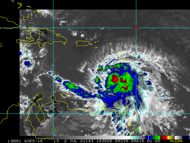
Elsa is a hurricane once again. Recon heading in to see just how strong.
7:30PM EDT July 6 Update
Recon is now heading back in, and there is a very good chance that Elsa is now, or will soon become, a hurricane once again. Recent model wind guidance also suggests peak gusts just offshore, in bays and just inland could be approaching 90 MPH, with that trend going up, and so with very wet ls that are only getting wetter, even any gusts above 40 MPH could begin creating damage, say nothing of 90MPH. It is also worth keeping in mind that taller and/or exposed buildings could see some even stronger gusts than those anticipated at the surface.
Flooding of all types are a serious hazard with Elsa, even after passage. Storm surge and inland flooding are all too often deadly. The time to rush preparations to protect life and property in the direct path and also to the right of Elsa is at hand.
Join the discussions:
Elsa Conditions in Your Areaand Elsa Forecast Lounge
Original Update
As forecast, Elsa has intensified over the warm eastern Gulf of Mexico, and recon has found that the cyclone has indeed strengthened beyond what most models were suggesting possible, but which believed was, and as such they had issued a Hurricane Watch for parts of western Florida early this morning. Those Hurricane Watches are going Hurricane Warnings.
Elsa Event Related Links
SFWMD Model Plot (Animated Model Plot) SFWMD Hurricane Page
[https://flhurricane.com/floatanimator.php?year=2021&storm=5 Flhurricane Satellite Floater Animation of Elsa
GOES Floater
Animated Model Plot of Elsa
Clark Evans Track Model Plot of Elsa
(Animated!) Model Plots in Google Earth - In Google Maps
Clark Evans Intensity Model Plot of Elsa (Animated!)
Clark Evans Track Plot of Elsa
Other Model Charts from Clark
Clark Evans Top 10 Analog Storms for Elsa
More model runs on from RAL/Jonathan Vigh's page
NRL Info on Elsa -- RAMMB Info
COD Atlantic Satellite View
Northeast Gulf Links
Southeast Composite Radar Loop
(Latest Static)
Tampa Bay, FL Radar Radar Loop
(Latest Static)
Key West, FL Radar Radar Loop
(Latest Static)
Mobile, AL Radar Radar Loop
(Latest Static)
Tallahassee FL Radar Radar Loop
(Latest Static)
Northwest Florida Radar Radar Loop
(Latest Static)
Gulf of Mexico Satellite Imagery
SFWMD Full Florida Radar (Includes east LA, MS,AL) Loop with Storm Track
Area Forecast Discussions:
New Orleans -
Mississippi/Alabama/Pensacola -
Panhandle/Tallahassee -
Tampa/West Central Florida
Florida Power Outage Maps
Duke Energy Florida Outage Map - Most of Central and Northern Florida
Florida Power and Light Outage Map (Much of South Florida)
Orlando Utilities Commision Outage Map
Tampa Electric Outage Map
JEA (Jacksonville) Outage Map
Gulf Power (Western Panhandle)
Clay Electric Outage Map (Gainsville/ North Central Florida area)
Lakeland Electric Outage Map
Peace River Electrical Cooperative outage map south Central Florida from east of Bradenton, north of North Port to West of Palm Bay and Vero Beach
Southwest Florida (Naples/Ft.Myers) Area Media:
WINK News 11 Fort Myers CBS
WBBH NBC 2 Fort Myers NBC
ABC 7 Naples ABC
FOX 4 Florida Cape Coral FOX
WFSX Fox 92.5 News Radio
WCCF News Radio 1580 Port Charlotte
News Press
Naples Daily News
Tampa Area Media:
Bay News 9
WFLA News 8 (NBC)
Bay Action News (ABC)
WTSP Channel 10 (CBS)
My Fox Tampa Bay
WWSB ABC 7 Sarasota
Tampa Bay Times
Tampa Bay Online
Sarasota Herald Tribune
970 WFLA Tampa News/Talk Radio
Edited by MikeC (Wed Jul 14 2021 08:43 AM)
 Threaded


