8AM EDT 21 August 2021 Update
Hurricane Grace made landfall just south of Tuxpan Mexico with 125mph winds overnight.
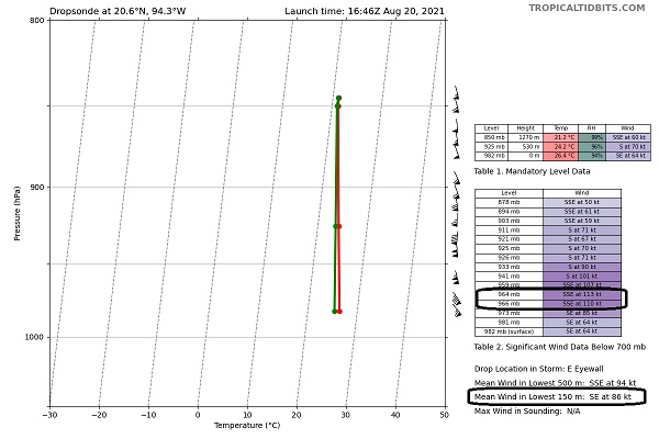
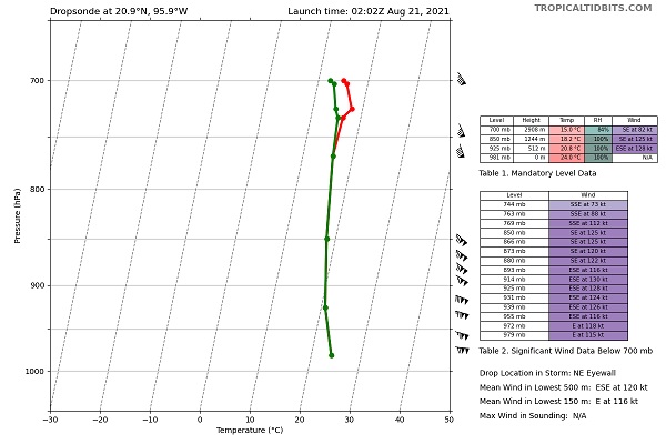
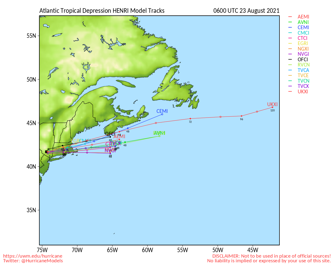
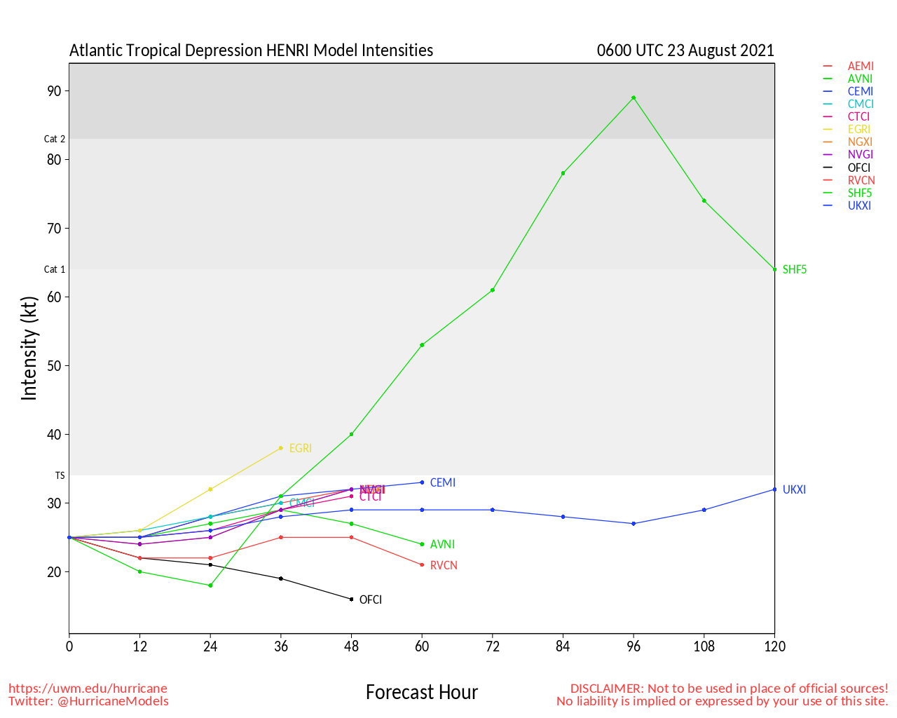
Henri is still a tropical storm as of 8AM, but the convection is starting to wrap around the center today and latest recon report suggests an upgrade to hurricane will happen shortly.. The forecast calls for Henri to peak between 80-85mph before reaching cooler waters. With the structure of the system not likely being fully symmetric, the timing for landfall would likely have much of the rainfall on the west side of the center, while the right would have more of the onshore surge. The landfall is forecast to be near the east end of Long Island. Southerly flow on the west (or left) side of the center is more risky for sound side surge, whereas northerly, onshore is more likely on the east side (or right of the center).
Considering as it weakens close to land the windfield will likely expand, the surge may be high well east of where the center makes landfall, including RI, Martha's Vineyard and Nantucket.
The good news is that it's taking its time to organize this morning, so a higher category hurricane is unlikely, however the impact is still likely to be quite high on the area in regards to rainfall, power outages, and surge as well as the potential for a few tornadoes.
5PM EDT 20 August 2021 Update
Henri is almost a hurricane and is close enough for hurricane warnings to go up in addition to the watch.
Storm Surge Warning is in effect for the south shore of Long
Island from Mastic Beach to Montauk Point, the north shore of
Long Island from Oyster Bay to Montauk Point, from Greenwich,
Connecticut to Chatham, Massachusetts, including Nantucket,
Martha`s Vineyard, and Block Island.
A Hurricane Warning is in effect for the south shore of Long Island
from Fire Island Inlet to Montauk Point, for the north shore of Long
Island from Port Jefferson Harbor to Montauk Point, and from New
Haven, Connecticut, to west of Watch Hill, Rhode Island.
A Tropical Storm Warning is in effect from west of Port Jefferson
Harbor to west of New Haven, Connecticut, and for the south shore
of Long Island from west of Fire Island Inlet to East Rockaway
Inlet.
A Tropical Storm Watch in effect from Manasquan Inlet, New Jersey,
to west of East Rockaway Inlet, New York, including New York City.
current surge estimates:
Watch Hill, RI to Chatham, MA including Narragansett Bay,
Buzzards Bay, Vineyard Sound, and Nantucket Sound...3-5 ft
Chatham, MA to Sagamore Beach, MA including Cape Cod Bay...2-4 ft
East Rockaway Inlet, NY to Montauk Point, NY...2-4 ft
North shore of Long Island...2-4 ft
Flushing, NY to Watch Hill, RI...2-4 ft
Cape May, NJ to East Rockaway Inlet, NY...1-3 ft
Recon is on its way tonight, shear is expected to relax overnight and Henri is likely to strengthen tomorrow while over the Gulf Stream.
For Grace there is a hurricane warning fro the coast of mainland Mexico from Puerto Veracruz to Cabo Rojo. It is forecast to be a category 2 hurricane at landfall.
6AM EDT 20 August 2021 Update
A Storm Surge Watch is in effect for...
* South Shore of Long Island from East Rockaway Inlet to Montauk
* North Shore of Long Island from Kings Point to Montauk
* Kings Point New York to Sagamore Beach Massachusetts
* Nantucket, Martha's Vineyard, and Block Island
A Hurricane Watch is in effect for...
* South Shore of Long Island from Fire Island Inlet to Montauk
* North Shore of Long Island from Port Jefferson Harbor to Montauk
* New Haven Connecticut to Sagamore Beach Massachusetts
* Nantucket, Martha's Vineyard, and Block Island
A Tropical Storm Watch is in effect for...
* West of Fire Island Inlet to East Rockaway Inlet New York
* West of Port Jefferson Harbor New York
* West of New Haven Connecticut
Henri is expected to become a hurricane late today or tomorrow, as the shear is expected to weaken more later today and then enter more favorable conditions for strengthening. The forecast track taking it currently toward Rhode Island, with a great potential for surge at and to the right of the center, and north facing shores of the islands on the left hand side as a category 1 hurricane and slowing forward motion as it makes landfall. Current surge projections are 3-5 feet in some areas, and could go higher if Henri strengthens more than forecast since It is possible Henri strengthens more while over the Gulf Stream, particularly tomorrow.
Grace is expected to become a hurricane later today as it heads north of Veracruz in Mexico. The mountains of Mexico will likely dissipate the main center, however the remnants of Grace are expected to move into the Pacific where they are likely to spawn a new tropical system in the East Pacific where it has an 80% chance to regenerate there.
There is an area in the east atlantic with a 20% chance for development.
5PM EDT 19 August 2021 Update
Tropical Storm Henri was a bit weaker today due to shear, when recon went out to discover it, but conditions are starting to improve and it will likely begin to strengthen tomorrow into Saturday. Landfall as a hurricane is now forecast for New England, watches for parts of Rhode Island and Massachusetts and possibly long island are likely starting tomorrow.
It should be noted that as Henri gains latitude and moves near New England, the wind field is expected to expand. Therefore, users are reminded to not focus on the exact forecast points as impacts will extend far from the center.
Grace is nearly back over water in the Bay of Campeche, and expected to regain hurricane strength before landfall.
Original Update
Grace is now a Hurricane heading west toward Cozumel in Mexico, it should arrive tomorrow morning there.
Henri is nearly a hurricane and the official track puts all of New England in the Forecast Cone. Those in the area should pay attention to updates as they come. Also those along the Mid Atlantic East coast from the Outer Banks north should be careful as rip currents may be very strong offshore due to Henri.
Fred's remnants are over parts Pennsylvania today, and are still causing flooding rainfall in some locations.
Henri Event Related Links
SFWMD Model Plot (Animated Model Plot) SFWMD Hurricane Page
[https://flhurricane.com/floatanimator.php?year=2021&storm=8 Flhurricane Satellite Floater Animation of Henri
GOES Floater
Animated Model Plot of Henri
Clark Evans Track Model Plot of Henri
(Animated!) Model Plots in Google Earth - In Google Maps
Clark Evans Intensity Model Plot of Henri (Animated!)
Clark Evans Track Plot of Henri
Other Model Charts from Clark
Clark Evans Top 10 Analog Storms for Henri
More model runs on from RAL/Jonathan Vigh's page
NRL Info on Henri -- RAMMB Info
COD Atlantic Satellite View
Henri Forecast Lounge
Grace Event Related Links
SFWMD Model Plot (Animated Model Plot) SFWMD Hurricane Page
[https://flhurricane.com/floatanimator.php?year=2021&storm=7 Flhurricane Satellite Floater Animation of Grace
GOES Floater
Animated Model Plot of Grace
Clark Evans Track Model Plot of Grace
(Animated!) Model Plots in Google Earth - In Google Maps
Clark Evans Intensity Model Plot of Grace (Animated!)
Clark Evans Track Plot of Grace
Other Model Charts from Clark
Clark Evans Top 10 Analog Storms for Grace
More model runs on from RAL/Jonathan Vigh's page
NRL Info on Grace -- RAMMB Info
COD Atlantic Satellite View
Grace Forecast Lounge
StormCarib Reports from the Caribbean Islands
Caribbean Weather Observations
Barbados Brohav Weather Fax
Full Caribbean Radar Composite
Caribbean Broadcast Corporation (TV/Radio from Antilles)
San Juan, PR NWS Page
Various Caribbean Radio Stations
DR1 Dominican Republic Hurricanes
Northeast US Radar Links
Northeast Composite Radar Loop
(Latest Static)
Dover, DE Radar Radar Loop
(Latest Static)
Mt. Holly, NJ Radar Radar Loop
(Latest Static)
Upton/NYC/Long Island, NY Radar Radar Loop
(Latest Static)
Boston/Cape Cod, MA Radar Radar Loop
(Latest Static)
Portland, ME Radar Radar Loop
(Latest Static)
Carabou, ME Radar Radar Loop
(Latest Static)
Mid-Atlantic/Carolina Links
Southeast Composite Radar Loop
(Latest Static)
Charleston, SC Radar Radar Loop
(Latest Static)
Wilmington, NC Radar Radar Loop
(Latest Static)
Morehead City, NC Radar Radar Loop
(Latest Static)
Norfolk/Wakefield, VA Radar Radar Loop
(Latest Static)
Area Forecast Discussions:
Charleston, SC -
Wilmington, NC -
Morehead City, NC -
Norfolk/Virginia Beach/Hampton Roads, VA
Power Outage Maps:
South Carolina Power Outage Map
North Carolina Power Outage Map
Virginia Power Outage Map
Bermuda Newspapers/Media:
BerNews
Royal Gazette (Bermuda)
Bermuda Sun
Hott 107.5 Bermuda Radio
Storm Carib Bermuda Reports
Bermuda Weather Service
 Threaded


