11:00PM EDT 27 August 2021 Update
Hurricane Ida is now in the Gulf of Mexico, still intact after crossing the western part of Cuba. It made landfall 20 miles east of La Coloma in Cuba. It continues be forecast to be an extremely dangerous category 4 hurricane when it reaches the coast of Louisiana Sunday afternoon and evening. Hurricane-force winds are expected Sunday in portions of the Hurricane Warning area along the Louisiana coast, including metropolitan New Orleans, with potentially catastrophic wind damage possible where the core of Ida moves onshore.
Surge of up to 15 feet is possible from Morgan City, LA to Mouth of the Mississippi River, and other areas, including a lot of the Mississippi coastline, can see surge up to .7-11 ft in some areas. Places at and just to the right of the landfall point will see the most onshore surge flow, there will be decreasing surge even to the FL/AL line. Please check the hurricane local statement and public advisory for more information.
Actions to protect life and property should be rushed to completion in the warning area on Saturday before dark, if possible, conditions will begin to deteriorate in the Warning area early Sunday morning. There are many active evacuation orders in parts of Southeastern Louisiana, listen to local media and officials to gain more information. If you live in a mandatory evacuation zone, please plan to evacuate.
For the best information for your local area consult local media and officials, an the area National Weather Service office.
5:30PM EDT 27 August 2021 Update
Hurricane Ida currently moving over Western Cuba, is forecast to be an extremely dangerous category 4 hurricane when it reaches the coast of Louisiana Sunday afternoon and evening. Hurricane-force winds are expected Sunday in portions of the Hurricane Warning area along the Louisiana coast, including metropolitan New Orleans, with potentially catastrophic wind damage possible where the core of Ida moves onshore.
Surge of up to 15 feet is possible from Morgan City, LA to Mouth of the Mississippi River, and other areas, including a lot of the Mississippi coastline, can see surge up to .7-11 ft in some areas. Places at and just to the right of the landfall point will see the most onshore surge flow, there will be decreasing surge even to the FL/AL line. Please check the hurricane local statement and public advisory for more information.
Actions to protect life and property should be rushed to completion in the warning area. Today and Tomorrow. There are active evacuation orders in parts of Southeastern Louisiana, listen to local media and officials to gain more information. If you live in a mandatory evacuation zone, please plan to evacuate.
For the best information for your local area consult local media and officials, an the area National Weather Service office.
1:30PM EDT 27 August 2021 Update
Ida is now officially a hurricane with the recon reporting winds enough for 75mph..
11:00AM EDT 27 August 2021 Update
Ida's stronger this morning and may become a hurricane this afternoon. Hurricane Warnings are now up for Cuba and the Isle of Youth. Hurricane Watches remain along the coast for most of Louisiana and all of Mississippi.
Those along the gulf coast under the watch, today is the best day to prepare. You also have tomorrow, but Sunday will be very limited. Rule of thumb here, plan for 1 category above forecast (aka 4) and hope for the best.
4:30AM EDT 27 August 2021 Update
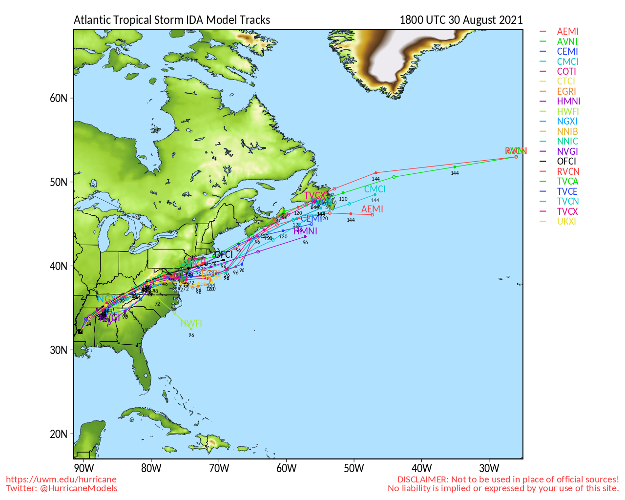
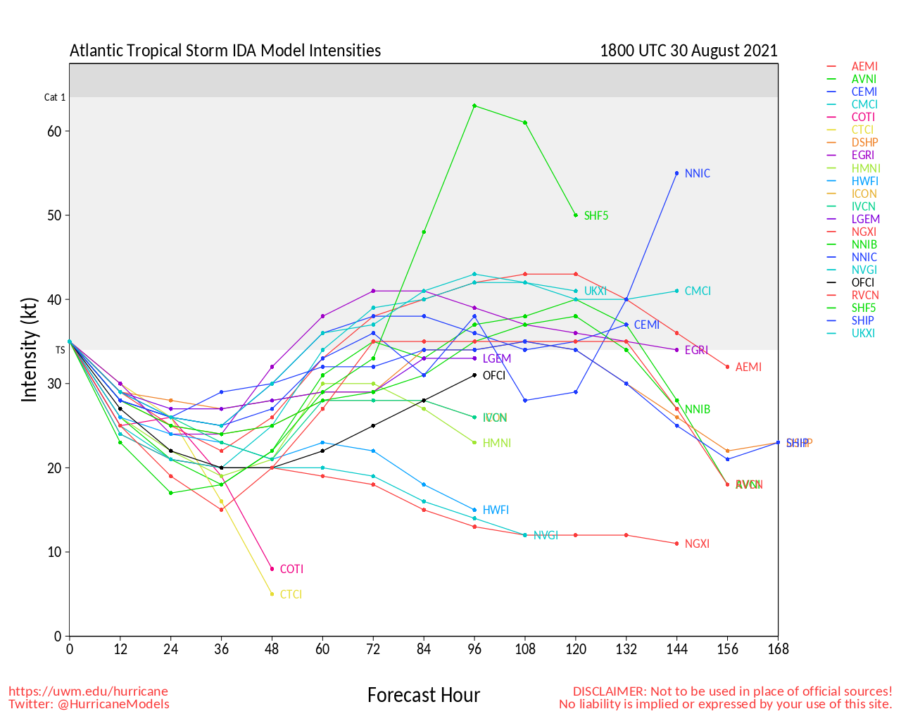
The second, third and fourth recon missions into Ida are underway, and we need them. While models are almost unanimously now forecasting a Louisiana landfall, this is still based on what was a bit of a diffuse surface center+robust mid-level circulation being tracked, as opposed to a more fully matured TD.
Recon #2 is presently out sampling the upper air data surrounding Ida. Missions #3 and #4 will probably be focused on ascertaining storm structure and current intensity. This and additional critical information coming in this morning should make for more reliable model output tonight.
Caveats aside, all indications are that Ida will be a very dangerous and powerful hurricane - and quite possibly a Major - and possibly even a sizeable Major - heading into landfall somewhere along the central Gulf coast bounded by the upper Texas coast to the left and possibly even the MS/AL/FL area to the east, and as quickly as this has come together, preps to protect life and property will not have the usual several days lead time.
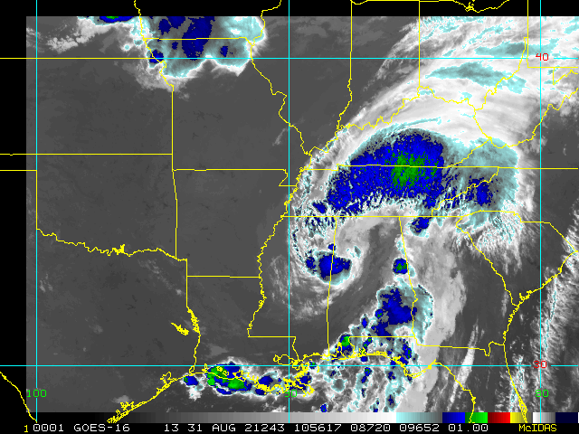
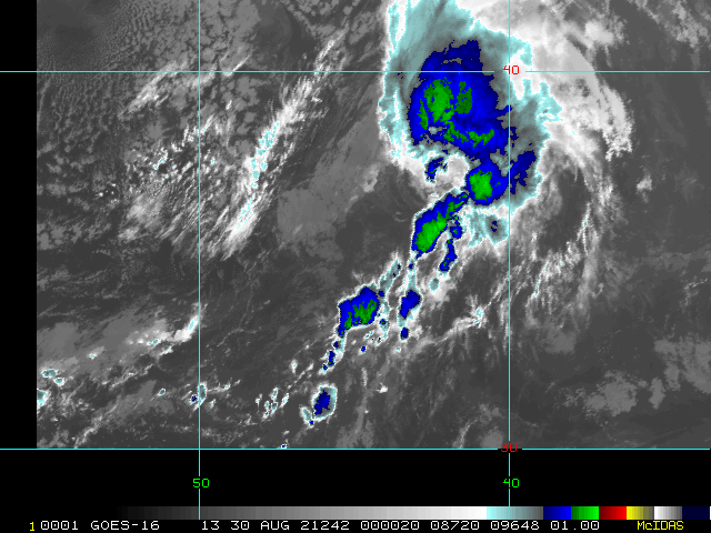
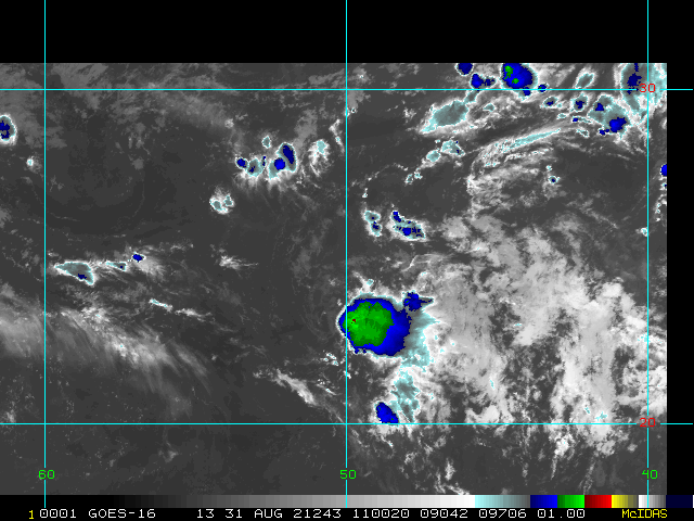
Elsewhere, Invest 97L is headed out to sea. Invest 98L has a non-zero chance of getting further west than forecast, and we are monitoring it closely in case of this. Also, a weak area of low pressure with a well-defined but small surface circulation is approaching the central Texas coast this morning with bursts of locally heavy and blustery thunderstorms that could catch some morning commuters off guard.
As a reminder, less restricted model talk (analysis, speculation, curiosities,etc.) on Ida and more is open in the 2021 Forecast Lounge
-Ciel
11:00PM EDT 26 August 2021 Update
Ida is still a tropical storm, but forecast to become a hurricane, so a Hurricane Watch has been issued from Cameron, LA eastward to the MS/AL border, including Lakes Pontchartrain, Maurepas, and the city of New Orleans.
Although Ida has been seeing shear today causing the system to be asymmetric, the models and conditions become quite favorable tomorrow night, and the water temperatures are warm. It is currently forecast to become a category 2 hurricane at landfall, but there is a distinct possibility it could become a major hurricane before landfall. Ida likely will make landfall in Louisiana late Sunday or early Monday, however conditions may extend quite well eastward, thus the Mississippi Gulf coast is also under a hurricane warning.
Based on all of this information, there is higher-than-normal confidence that a significant hurricane will be approaching the Gulf coast late in the weekend. Time to prepare is tomorrow and Saturday. Listen to local officials and media for the best information for your local area.
8:00PM EDT 26 August 2021 Update
Tropical Storm Ida has formed west of Jamaica, with it currently approaching the Cayman islands and western Cuba, beyond there it is expected to become a hurricane in the Gulf of Mexico as it goes over very warm waters.
The forecast calls for a category 2 hurricane in the north central Gulf coast, but there is room for it to reach major status before landfall. Those in the cone area should be preparing tomorrow and Saturday, as Sunday will begin to deteriorate in the area. There's still some uncertainty how strong it may get, which should become clearer a bit after it enters the Gulf on Saturday. However, it would be wise to use tomorrow for preparations regardless because Saturday will be the last practical day to prepare.
5:20PM EDT 26 August 2021 Update
An Air Force Reserve hurricane hunter aircraft data indicate that the depression has strengthened to Tropical Storm Ida. The maximum sustained winds are estimated to be 40 mph (65 km/h) with higher gusts.
The left bar and graphics will update with the 8pm advisory, but it is officially Tropical Storm Ida now.
Original Update
Tropical Depression Nine has formed west of Jamaica this morning and is expected to Cross the western tip of Cuba later tonight into tomorrow. Ida is the next name on the list.
Tropical Storm Warnings are up for the Cayman Islands and Western Parts of Cuba and the Isle of Youth.
Those in the cone along the Gulf of Mexico should start to prepare today or tomorrow, if possible, as Conditions may begin to deteriorate by early to midday Sunday. The current forecast has a strengthening category 2 hurricane making landfall in Central Louisiana Sunday night, but there is a good chance it will become a major hurricane right before landfall. Some shifts in the track are likely until the system consolidates and becomes better defined.
Ida Event Related Links
SFWMD Model Plot (Animated Model Plot) SFWMD Hurricane Page
[https://flhurricane.com/floatanimator.php?year=2021&storm=9 Flhurricane Satellite Floater Animation of Ida
GOES Floater
Animated Model Plot of Ida
Clark Evans Track Model Plot of Ida
(Animated!) Model Plots in Google Earth - In Google Maps
Clark Evans Intensity Model Plot of Ida (Animated!)
Clark Evans Track Plot of Ida
Other Model Charts from Clark
Clark Evans Top 10 Analog Storms for Ida
More model runs on from RAL/Jonathan Vigh's page
NRL Info on Ida -- RAMMB Info
COD Atlantic Satellite View
North Gulf Links
North Gulf/Southern Mississippi Valley Composite Radar Loop
(Latest Static)
East to West:
Mobile, AL Radar Radar Loop
(Latest Static)
New Orleans, LA Radar Radar Loop
(Latest Static)
Lake Charles, LA Radar Radar Loop
(Latest Static)
Houston/Galveston, TX Radar Radar Loop
(Latest Static)
Gulf of Mexico Satellite Imagery
Area Forecast Discussions:
Mississippi/Alabama/Pensacola -
New Orleans, LA -
Lake Charles, LA -
Houston/Galveston, TX
Mississippi/Alabama Gulf Coast Media/Links
WLOX TV 13 (ABC) Biloxi
WXXV TV 25 (Fox)Biloxi
WKRG TV 5 (CBS) Mobile
WPMI TV 15 (NBC) Mobile
WALA TV 10 (Fox) Mobile
WEAR TV 3 (ABC) Pensacola, FL
Newspapers
Mobile Register (Al.com) paper
Biloxi Sun Herald paper
Gulf Live
Radio (some)
News Talk 104.9 Biloxi, MS (Radio)
News talk 106.5 Mobile, AL (Radio)
Power Outage
Louisiana power outage map
Mississippi Power Outage Map
Alabama Power Outage Map
>
- Lake Charles, LA Area Media and Information
kplctv 7 NBC Lake Charles
Fox 29 Lake Charles
American Press Newspaper Lake Charles
Louisiana Information
Govt/Official Info:
Louisiana Emergency Management
Mississippi Emergency Management
Alabama Emergency Management
Louisiana Dept. of Transportation - Road Closures, Traffic Cams, etc.
Mississippi - Road Closures, Traffic Cams, etc
Alabama Road Conditions and Traffic Cameras
Media Newspapers/TV/Radio:
Nola.com New Orleans Times-Picayune
WWL TV 4 (CBS Affiliate in New Orleans)
ABC 26 TV (ABC Affiliate in New Orleans)
WDSU Channel 6 (NBC Affiliate New Orleans)
Fox 8 (New Orleans)
WTIX 690 News Radio
WWL 870 News Radio
WTOK 11 / Missippii Alabama ABC Affiliate
WKRG 5 in Mobile/Pensacola
WPMI Channel 15 from Mobile
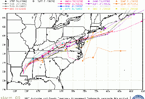
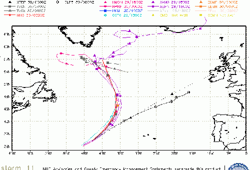
Invest 97L Event Related Links
SFWMD Model Plot (Animated Model Plot) SFWMD Hurricane Page
[https://flhurricane.com/floatanimator.php?year=2021&storm=12 Flhurricane Satellite Floater Animation of 97L
GOES Floater
Animated Model Plot of 97L
Clark Evans Track Model Plot of 97L
(Animated!) Model Plots in Google Earth - In Google Maps
Clark Evans Intensity Model Plot of 97L (Animated!)
Clark Evans Track Plot of 97L
Other Model Charts from Clark
Clark Evans Top 10 Analog Storms for 97L
More model runs on from RAL/Jonathan Vigh's page
NRL Info on 97L -- RAMMB Info
COD Atlantic Satellite View
Invest 98L Event Related Links
SFWMD Model Plot (Animated Model Plot) SFWMD Hurricane Page
[https://flhurricane.com/floatanimator.php?year=2021&storm=10 Flhurricane Satellite Floater Animation of 98L
GOES Floater
Animated Model Plot of 98L
Clark Evans Track Model Plot of 98L
(Animated!) Model Plots in Google Earth - In Google Maps
Clark Evans Intensity Model Plot of 98L (Animated!)
Clark Evans Track Plot of 98L
Other Model Charts from Clark
Clark Evans Top 10 Analog Storms for 98L
More model runs on from RAL/Jonathan Vigh's page
NRL Info on 98L -- RAMMB Info
COD Atlantic Satellite View
 Threaded


