cieldumort
Moderator

Reged: Mon
Posts: 2305
Loc: Austin, Tx
|
|
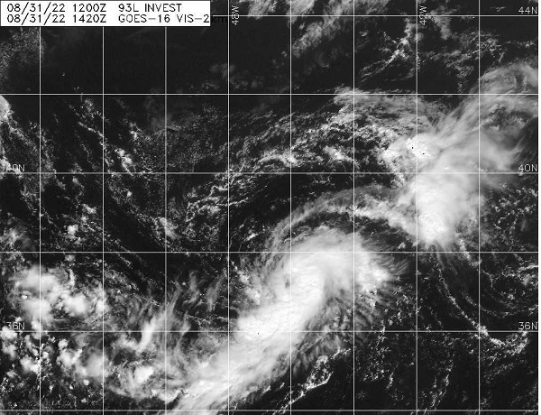
A decaying frontal boundary is transitioning into a tropical entity today, and a tropical storm is likely forming in the subtropics, west of the Azores. This system has been Invest tagged 93L this morning. Because this system may present a threat to both the Azores and, even western Europe, we are starting a Forecast Lounge on this system now.
Invest 93L has become Five, on the first day of September, and the title has been updated accordingly (now Danielle) -Ciel
|
cieldumort
Moderator
Reged: Mon
Posts: 2305
Loc: Austin, Tx
|
|
Invest 93L is much better organized than 91L and tonight has just about shed its frontal beginnings. With a tight and well-defined LLC and abundant and increasingly organized convection, odds on that 93L, and not 91L, becomes the next system for to classify. While there is some chance that it is initially called sub-tropical, it does appear to be more tropical than not.
As for track and intensity, 93L does have the mechanics and environment to become a strong tropical storm and possibly a hurricane. Indeed, this is increasingly advertised in the models.
Here are some of the most recent model forecasts:
09010z HWRF Tropical quickly gaining hurricane status by Friday night while drifting north.
09010z HMON Tropical quickly gaining hurricane status by Friday afternoon while meandering almost in place
083112z HAFS Strong tropical storm by Friday night and hurricane by early Saturday. Major by early Sunday all while meandering north.
09010z Strong tropical storm by early Friday and hurricane by midday Saturday. Meandering in the near-term then racing ENE later in the run.
All in all, 93L will likely be named later this morning. The next name on the list is Danielle.
|
|
 Threaded


