11:45PM EDT 21 September 2022 Update
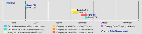
Image cr: Wikipedia
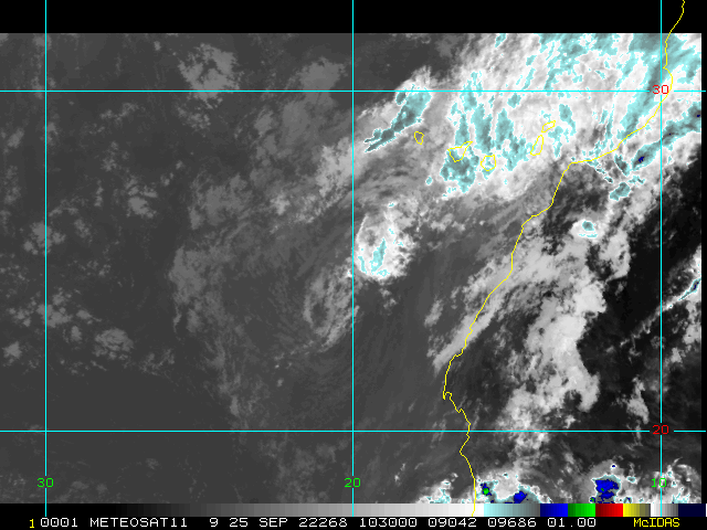
It can not be overstated just how much of a 180 the Atlantic basin has made, and many land-based locations are now at continued or increasing risk of serious impacts. With the addition of 99L and basically a "landphoon" rolling off westernmost Africa, there are now two active named tropical cyclones plus three almost tropical cyclones out there.
Recon has just completed a survey of the environment over the Caribbean in the immediate vicinity of Invest 98L, which is now 90% odds of becoming a numbered tropical cyclone within 5 days. The data collected by this mission will be invaluable in modeling and forecasts. There are factors that could delay organization, but probably only delay. There are other factors that could steer it away from the northern Gulf of Mexico, but at present, models are continuing to sniff out a western Caribbean to Gulf coastal states threat in the mid/long-range (Please see 98L Forecast Lounge for more on this).
The next three names on the list in the 2022 season are: Hermine, Ian and Julia.
-Ciel
8PM EDT 21 September 2022 Update
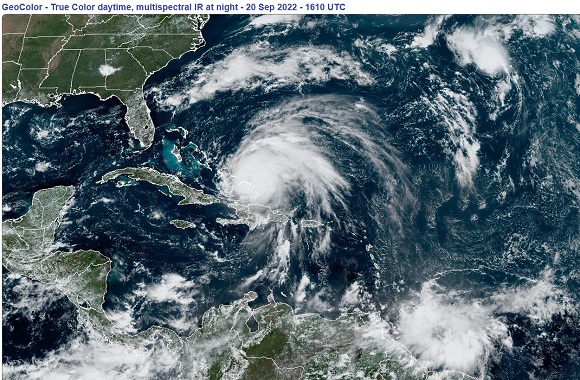
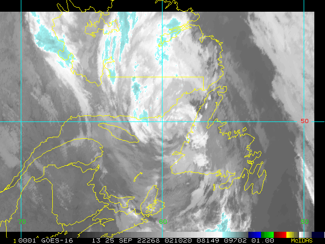
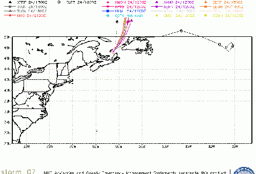
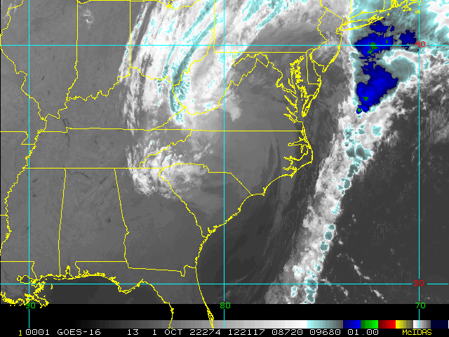
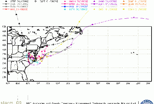
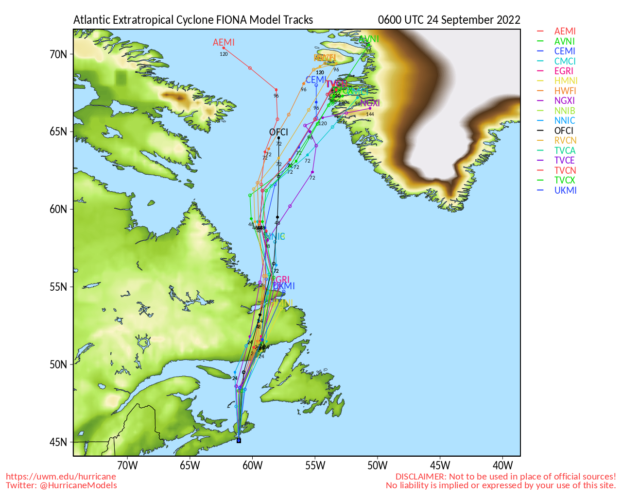
Category 4 Hurricane Fiona is starting to move faster to the North and should be near Bermuda late tomorrow night into Friday morning, and then head up to Atlantic Canada as an , but extremely powerful storm. It should landfall near the eastern end of Nova Scotia on Saturday morning.
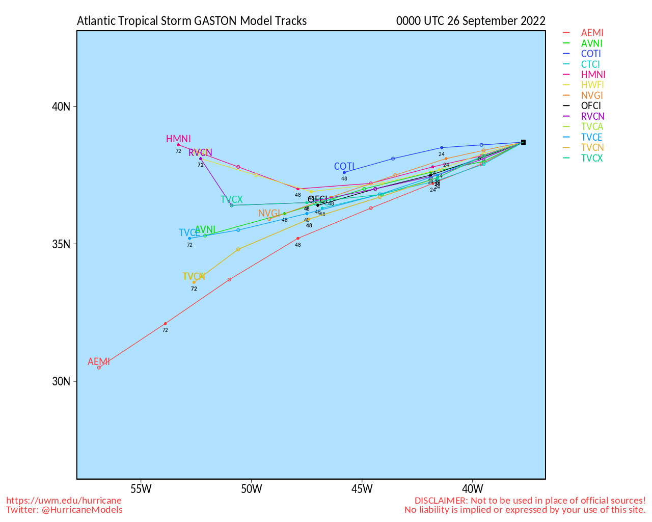
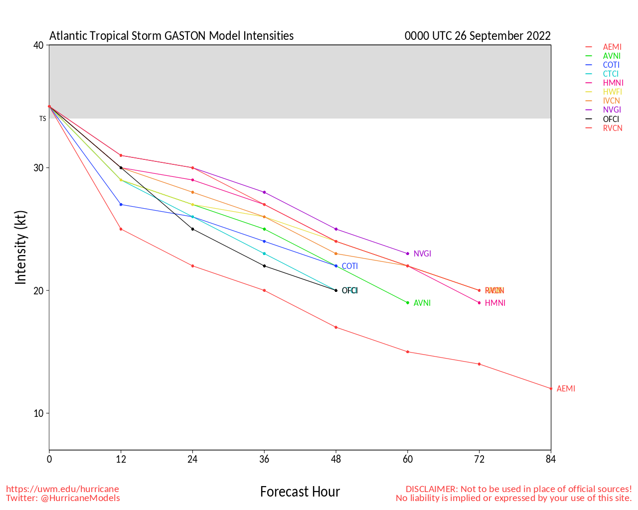
Gaston is moving generally slowly and will get near the Azores sometime Saturday before moving back east on the forecast and becoming .
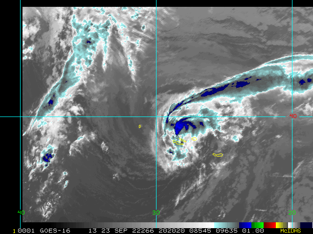
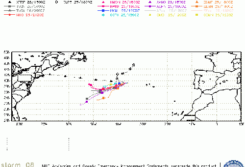
98L is likely to remain disorganized for another few days until it gets west of the ABC islands, but remains something that should be watched closely for those in the Cayman Islands, Western Cuba, Yucatan Peninsula, and Central Gulf as well as Florida into next week. There is a great deal of uncertainty after 5 days or so. Recon is out sampling the area tonight to hopefully improve the modeling on this system in the near future.
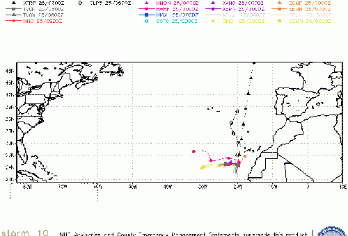
Two other areas, one has a 60% chance for development offshore of Africa, and another in the east central Atlantic with a 30% chance for development.
8AM EDT 21 September 2022 Update
The season is making up for a extended slow start. Fiona looks like it'll pass west of Bermuda enough to not cause too many problems, however Nova Scotia in Canada is going to get hit by a system turning into more of a hybrid noreaster but with the pressure and power of a category 4 hurricane.
The Turks and Caicos got hit pretty hard yesterday, particularly Grand Turk.
98L is now up to a 90% chance for development and this is the one we need to watch in Florida, particularly late next week (Thursday-Saturday) still too far out to say exactly what will happen, but all of Florida to about coastal Mississippi should monitor it closely. It has not developed yet, but likely will in 2-3 days. The Windward islands of the Caribbean will be impacted first, but mostly by rain and squalls before moving into the Caribbean. It will likely not develop until in the Caribbean sea itself.
Gaston is still moving in the north Atlantic, the Azores should monitor it. Two other areas, one off Africa has a 50% chance for development, but will likely stay away from land, and another in the Central Atlantic with a 30% chance to develop.
8PM EDT 20 September 2022 Update
Busy day in the Atlantic Tropics. Gaston has formed from 97L, but it is likely to stay out to sea, however it may get very close to the Azores. So folks in those islands should watch it closely.
Fiona is moving away from the Turks and Caicos, and likely to stay west of Bermuda, however it's increasingly likely it may reach Nova Scotia in Canada as a very powerful hurricane or storm.
98L is the system east of the Caribbean that the windward islands should watch, it is now up to a 90% chance to develop over the next 5 days. This storm should be watched by most of the Caribbean, Yucatan Peninsula, Florida and the Central Gulf coasts closely into next week.
Another area off Africa has a 40% chance to develop, those in the Cape/Cabo Verde islands should monitor that.
5PM 20 September 2022 Update
TD#8 has been upgraded to Tropical Storm Gaston, and already looks to be ramping up even more quickly from there.
Original Update
The Atlantic basin is on track for another serious season, even if total numbers come in below forecasts.
After producing Harvey-like catastrophic flooding in Puerto Rico and portions of the Dominican Republic, Hurricane Fiona moved back out over open water, resumed intensifying, and became 2022's first Major. Major Hurricane Fiona is now impacting the eastern Bahamas early this week, before likely whacking Bermuda with the stronger eastern semicircle (with perhaps a direct hit), and then probably move on to striking Nova Scotia as a violent hurricane-force storm, either post-tropical or not.
Invest 97L in the subtropical Atlantic became TD 8 this morning. Interests in the Azores may want to monitor this cyclone.
Our attention has quickly returned to the region just east of the Caribbean, where another stout tropical wave, 98L, now has high odds of becoming our next named storm and potential significant hurricane, and this time probably with a track that takes it further west than Fiona, with models largely already sniffing out risks from the Caribbean to the Gulf.
The next two names on the list in the Atlantic this year are Gaston and Hermine.
We have lounges up for both Fiona and 98L, where modelling is often discussed in greater detail: Fiona Forecast Lounge 98L Forecast Lounge
Fiona Event Related Links
SFWMD Model Plot (Animated Model Plot) SFWMD Hurricane Page
[https://flhurricane.com/floatanimator.php?year=2022&storm=7 Flhurricane Satellite Floater Animation of Fiona
GOES Floater
Animated Model Plot of Fiona
Clark Evans Track Model Plot of Fiona
(Animated!) Model Plots in Google Earth - In Google Maps
Clark Evans Intensity Model Plot of Fiona (Animated!)
Clark Evans Track Plot of Fiona
Other Model Charts from Clark
Clark Evans Top 10 Analog Storms for Fiona
More model runs on from RAL/Jonathan Vigh's page
NRL Info on Fiona -- RAMMB Info
COD Atlantic Satellite View
Gaston Event Related Links
SFWMD Model Plot (Animated Model Plot) SFWMD Hurricane Page
[https://flhurricane.com/floatanimator.php?year=2022&storm=8 Flhurricane Satellite Floater Animation of Gaston
GOES Floater
Animated Model Plot of Gaston
Clark Evans Track Model Plot of Gaston
(Animated!) Model Plots in Google Earth - In Google Maps
Clark Evans Intensity Model Plot of Gaston (Animated!)
Clark Evans Track Plot of Gaston
Other Model Charts from Clark
Clark Evans Top 10 Analog Storms for Gaston
More model runs on from RAL/Jonathan Vigh's page
NRL Info on Gaston -- RAMMB Info
COD Atlantic Satellite View
Invest 98L Event Related Links
SFWMD Model Plot (Animated Model Plot) SFWMD Hurricane Page
[https://flhurricane.com/floatanimator.php?year=2022&storm=9 Flhurricane Satellite Floater Animation of 98L
GOES Floater
Animated Model Plot of 98L
Clark Evans Track Model Plot of 98L
(Animated!) Model Plots in Google Earth - In Google Maps
Clark Evans Intensity Model Plot of 98L (Animated!)
Clark Evans Track Plot of 98L
Other Model Charts from Clark
Clark Evans Top 10 Analog Storms for 98L
More model runs on from RAL/Jonathan Vigh's page
NRL Info on 98L -- RAMMB Info
COD Atlantic Satellite View
Invest 99L Event Related Links
SFWMD Model Plot (Animated Model Plot) SFWMD Hurricane Page
[https://flhurricane.com/floatanimator.php?year=2022&storm=10 Flhurricane Satellite Floater Animation of 99L
GOES Floater
Animated Model Plot of 99L
Clark Evans Track Model Plot of 99L
(Animated!) Model Plots in Google Earth - In Google Maps
Clark Evans Intensity Model Plot of 99L (Animated!)
Clark Evans Track Plot of 99L
Other Model Charts from Clark
Clark Evans Top 10 Analog Storms for 99L
More model runs on from RAL/Jonathan Vigh's page
NRL Info on 99L -- RAMMB Info
COD Atlantic Satellite View
Invest 90L Event Related Links
SFWMD Model Plot (Animated Model Plot) SFWMD Hurricane Page
[https://flhurricane.com/floatanimator.php?year=2022&storm=11 Flhurricane Satellite Floater Animation of 90L
GOES Floater
Animated Model Plot of 90L
Clark Evans Track Model Plot of 90L
(Animated!) Model Plots in Google Earth - In Google Maps
Clark Evans Intensity Model Plot of 90L (Animated!)
Clark Evans Track Plot of 90L
Other Model Charts from Clark
Clark Evans Top 10 Analog Storms for 90L
More model runs on from RAL/Jonathan Vigh's page
NRL Info on 90L -- RAMMB Info
COD Atlantic Satellite View
StormCarib Reports from the Caribbean Islands
Caribbean Weather Observations
Barbados Brohav Weather Fax
Full Caribbean Radar Composite
Caribbean Broadcast Corporation (TV/Radio from Antilles)
San Juan, PR NWS Page
Various Caribbean Radio Stations
DR1 Dominican Republic Hurricanes
Bermuda Newspapers/Media:
BerNews
Royal Gazette (Bermuda)
Bermuda Sun
Hott 107.5 Bermuda Radio
Storm Carib Bermuda Reports
Bermuda Weather Service
Canadian Hurricane Centre
 Threaded


