Now a hybrid Hurricane Ian, the cyclone is restrengthening over the very warm waters off the southeast coast along the Gulf Stream, and is now back up to 85 MPH at the time of this post, and still strengthening. Storms like Ian tend to over-perform many models and indeed official forecasts, so residents in Ian's path should prepare for a full Category higher than forecast. That is also always a good thing to do, no matter the storm.
Ian or its remnants may make landfall, move inland, and then reemerge over the the Gulf Stream in a few days, but hopefully by that time up and away. For good.
Elsewhere, conditions across the Atlantic continue generally favorable for additional development. The "it only takes one" doesn't also necessarily mean, "and done."
For in-depth model analysis and a place for more speculative discussions, join us in the Ian Forecast Lounge
Ian Event Related Links
SFWMD Model Plot (Animated Model Plot) SFWMD Hurricane Page
[https://flhurricane.com/floatanimator.php?year=2022&storm=9 Flhurricane Satellite Floater Animation of Ian
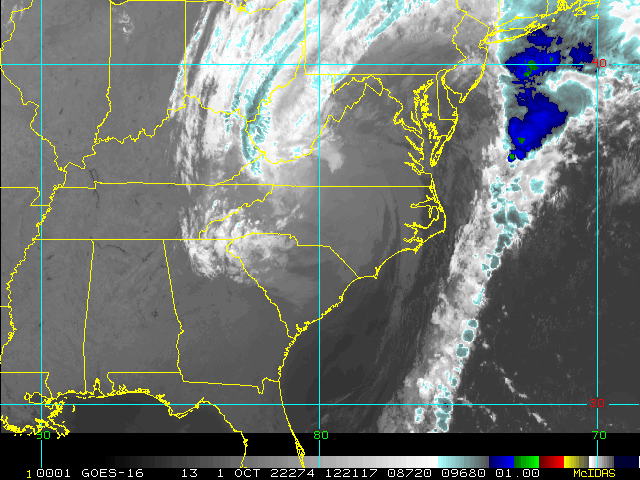
GOES Floater
Animated Model Plot of Ian
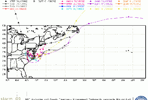
Clark Evans Track Model Plot of Ian
(Animated!) Model Plots in Google Earth - In Google Maps
Clark Evans Intensity Model Plot of Ian (Animated!)
Clark Evans Track Plot of Ian
Other Model Charts from Clark
Clark Evans Top 10 Analog Storms for Ian
More model runs on from RAL/Jonathan Vigh's page
NRL Info on Ian -- RAMMB Info
COD Atlantic Satellite View
Florida Emergency Management
Coastal South Carolina Media:
Myrtle Beach Sun News
Charleston Post and Courier
94.3 WSC Charleston News Radio
Power Outage Map: South Carolina Power Outage Map
Tampa Area Media:
Bay News 9
WFLA News 8 (NBC)
Bay Action News (ABC)
WTSP Channel 10 (CBS)
My Fox Tampa Bay
WWSB ABC 7 Sarasota
Tampa Bay Times
Tampa Bay Online
Sarasota Herald Tribune
970 WFLA Tampa News/Talk Radio
Southwest Florida (Naples/Ft.Myers) Area Media:
WINK News 11 Fort Myers CBS
WBBH NBC 2 Fort Myers NBC
ABC 7 Naples ABC
FOX 4 Florida Cape Coral FOX
WFSX Fox 92.5 News Radio
WCCF News Radio 1580 Port Charlotte
News Press
Naples Daily News
News Media (South Florida):
Television:
Newspapers:
News Radio:
Check local media and officials when a storm is approaching your area.
Northeast Gulf Links
Southeast Composite Radar Loop
(Latest Static)
Tampa Bay, FL Radar Radar Loop
(Latest Static)
Key West, FL Radar Radar Loop
(Latest Static)
Mobile, AL Radar Radar Loop
(Latest Static)
Tallahassee FL Radar Radar Loop
(Latest Static)
Northwest Florida Radar Radar Loop
(Latest Static)
Gulf of Mexico Satellite Imagery
SFWMD Full Florida Radar (Includes east LA, MS,AL) Loop with Storm Track
Area Forecast Discussions:
New Orleans -
Mississippi/Alabama/Pensacola -
Panhandle/Tallahassee -
Tampa/West Central Florida
News Media (East Central Florida):
Television:
Newspapers:
News Radio:
Check local media and officials when a storm is approaching your area.
Florida Power Outage Maps
Duke Energy Florida Outage Map - Most of Central and Northern Florida
Florida Power and Light Outage Map (Much of South Florida)
Orlando Utilities Commision Outage Map
Tampa Electric Outage Map
JEA (Jacksonville) Outage Map
Gulf Power (Western Panhandle)
Clay Electric Outage Map (Gainsville/ North Central Florida area)
Lakeland Electric Outage Map
Peace River Electrical Cooperative outage map south Central Florida from east of Bradenton, north of North Port to West of Palm Bay and Vero Beach
 Threaded


