cieldumort
Moderator

Reged: Mon
Posts: 2305
Loc: Austin, Tx
|
|
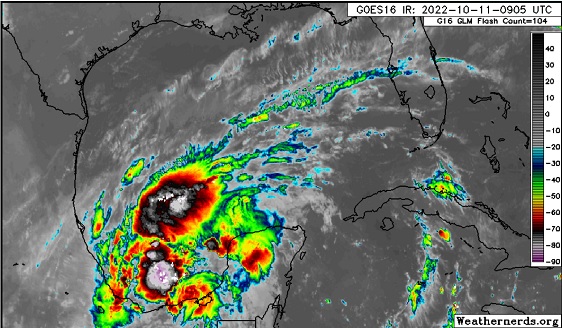
Image cr. Weathernerds.org
An area of low pressure largely associated with the remnants of former Hurricane Julia in the southwestern Gulf of Mexico is producing a sizeable area of disorganized showers and thunderstorms, which have been on the increase. This feature is likely to be Invest tagged today, and recon is tentatively scheduled to check it out later this afternoon, if necessary.
Models suggest that there is some possibility for this area of low pressure to not only become a TD or named storm within the next 12-72 hours, but also stick around for a while. Even though current forecasts tend to send the feature back into Mexico, given the likelihood of it having a chance to meander over and/or back and forth over water, steering currents may have a chance to change and open a window for a track further north at some point.
Very heavy rains and flooding are likely to continue in eastern Mexico in the near-term, regardless of development and ultimate tracks.
All things considered, we are starting a Lounge on Invest TBD at this time.
This system has been tagged 93L and the title has been updated accordingly. - Ciel
Edited by cieldumort (Tue Oct 11 2022 10:22 PM)
|
cieldumort
Moderator
Reged: Mon
Posts: 2305
Loc: Austin, Tx
|
|
Recon has found that Invest 93L was sufficiently organized to classify as a tropical cyclone, and with surface winds of at least 40 MPH, advisories have begun on Tropical Storm Karl. Early model runs generally agree on Karl tracking northwest before turning back around to the southwest and gradually making its away to a landfall in Mexico along the coast in the extreme southwestern Gulf of Mexico.
There are some indications that Karl may linger or meander a bit, and future runs may begin to diverse some in the extended range, and are worth keeping an eye on.
Intensity-wise, RI is not forecast, and considering the rather broad wind field and broad center, this makes sense. Of course, waters are quite toasty and the longer a TC has over toasty waters in favorable atmospheric conditions, the more something could change here, too.
|
|
 Threaded


