1:30PM EST 6 November 2022 Update
The area north of Puerto rico is up to 90% chance to develop in the next 5 days. The National Hurricane Center has indicated that tropical storm, hurricane, and storm surge watches could go up as early as tomorrow morning for parts of the Central and Northwestern Bahamas and Florida east coast for the system which would likely arrive in the middle part of the week (Wednesday Night or Thursday). Regardless of development or exact track, there is risk of coastal flooding, tropical storm force winds (with a high gradient driven pattern), heavy rain, rough surf and beach erosion along the east Florida coast. It's important to monitor this system closely over the next few days.
7AM EST 6 November 2022 Update
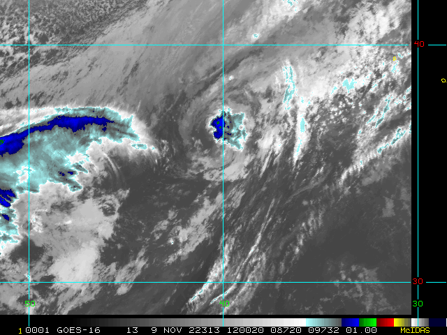
The area east of Bermuda has a 70% chance to develop.
The bigger story is the area north of Puerto Rico that now has a 90% chance to develop into a tropical or subtropical storm, now with most of the major forecast models projecting a potential hurricane approaching the Bahamas and Florida on top of it, forecast advisories are very likely to begin at least late today on this system. For local information please check officials and local media. It may be very close to Florida late Wednesday night or Early Thursday morning.
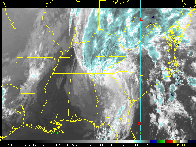
This system is likely going to a be a large system, with a large wind field because of strong pressure gradients with a high to the north, which will likely translate into a lot of coastal erosion and flooding along the east coast of Florida and north, potentially up to North Carolina. Beaches will likely be very dangerous for currents into the week. Rainfall from this area in Puerto Rico has brought flooding conditions there.
This system at least will be impactful to east Florida in the form of wind, rainfall, and dangerous beach/marine conditions. Depending on the system's strength and track, significant rainfall and increased flooding, surge and wind concerns may also unfold. Important to note that the pattern setting up for this allows this system to continue to strengthen even right up to a potential landfall.
Original Update
Two areas are red on the outlook map this evening, the area east of Bermuda (Invest 97L), which has a 70% chance to develop over the next 48 hours.
The other area, currently near Puerto Rico and heading toward the general vicinity of the Bahamas, has an 80% chance to develop over the next 5 days, and 50% in the next 48 hours. It's currently bringing flooding rainfall to parts of Puerto Rico. This system those in the Bahamas, Florida, and the Southeast US needs to watch closely as it has the potential to become tropical or subtropical over the next few days. And this along with a high pressure more to the north will likely create a large windfield which will increase risk of coastal flooding, erosion and very high surf along the east coast of Florida potentially up through North Carolina. There remains a possibility it could get stronger as well, so it's important that it be watched closely by those in the Bahamas and the east coast of Florida.
The next two names on the list are Nicole and Owen.
Nicole Event Related Links

SFWMD Model Plot (Animated Model Plot) SFWMD Hurricane Page
[https://flhurricane.com/floatanimator.php?year=2022&storm=17 Flhurricane Satellite Floater Animation of Nicole
GOES Floater
Animated Model Plot of Nicole
Clark Evans Track Model Plot of Nicole
(Animated!) Model Plots in Google Earth - In Google Maps
Clark Evans Intensity Model Plot of Nicole (Animated!)
Clark Evans Track Plot of Nicole
Other Model Charts from Clark
Clark Evans Top 10 Analog Storms for Nicole
More model runs on from RAL/Jonathan Vigh's page
NRL Info on Nicole -- RAMMB Info
COD Atlantic Satellite View
Invest 97L Event Related Links
SFWMD Model Plot (Animated Model Plot) SFWMD Hurricane Page
[https://flhurricane.com/floatanimator.php?year=2022&storm=18 Flhurricane Satellite Floater Animation of 97
GOES Floater
Animated Model Plot of 97
Clark Evans Track Model Plot of 97
(Animated!) Model Plots in Google Earth - In Google Maps
Clark Evans Intensity Model Plot of 97 (Animated!)
Clark Evans Track Plot of 97
Other Model Charts from Clark
Clark Evans Top 10 Analog Storms for 97
More model runs on from RAL/Jonathan Vigh's page
NRL Info on 97 -- RAMMB Info
COD Atlantic Satellite View
StormCarib Reports from the Caribbean Islands
Caribbean Weather Observations
Barbados Brohav Weather Fax
Full Caribbean Radar Composite
Caribbean Broadcast Corporation (TV/Radio from Antilles)
San Juan, PR NWS Page
Various Caribbean Radio Stations
DR1 Dominican Republic Hurricanes
> Bahamas Media
Bahamas Radar
Television & Radio:
ZNS Bahamas, Radio & TV
More 94 FM Bahamas
Newspapers:
Bahamas Tribune
Nassau Guardian
Bahamas B2B
The Abaconian - Abaco Island News
Freeport News
East Florida Links
Southeast Composite Radar Loop
(Latest Static)
South to North:
Key West, FL Radar Radar Loop
(Latest Static)
Miami, FL Radar Radar Loop
(Latest Static)
Melbourne, FL Radar Radar Loop
(Latest Static)
Jacksonville, FL Radar Radar Loop
(Latest Static)
Caribbean/South East Coast Satellite Imagery
SFWMD Radar Loop of South Florida with storm Track
SFWMD Full Florida Radar Loop with Storm Track
Area Forecast Discussions:
FLorida Keys -
Miami/South Florida -
Melbourne/East Central Florida -
Jacksonville/Northeast Florida -
News Media (South Florida):
Television:
Newspapers:
News Radio:
Check local media and officials when a storm is approaching your area.
News Media (East Central Florida):
Television:
Newspapers:
News Radio:
Check local media and officials when a storm is approaching your area.
 Threaded


