2:00 PM CDT 24 August 2023 Update
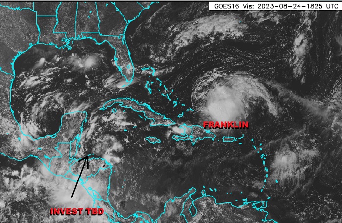
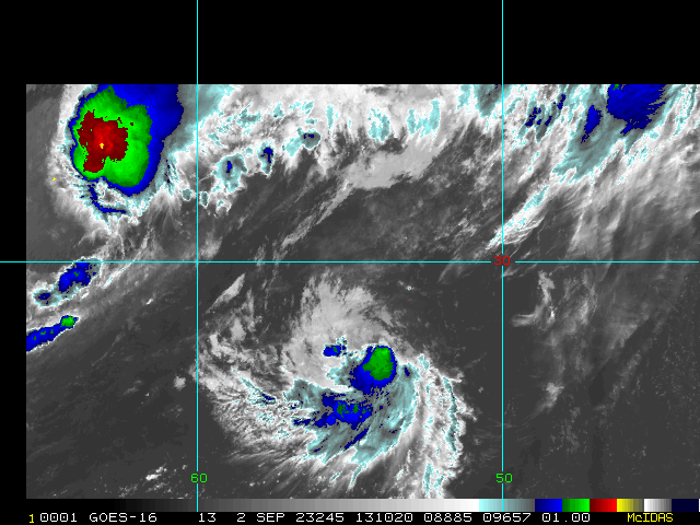
Above: Invest TBD and Tropical Storm Franklin. Base satellite image cr. Weathernerds.org
Very busy tropics continues in the Atlantic, and for those of us with interests from the western Caribbean into the central to eastern Gulf of Mexico, including Florida, a disturbance that will likely soon be Invest tagged is taking shape just on the East Pac side of Central America. This feature, likely soon Invest, has a possibly conservative 60% chance of development as of this update. Movement would most likely be generally north-northeast to northeast, thus taking it into Florida early next week on such a track, and could become a strong tropical storm and even hurricane.
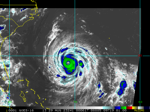
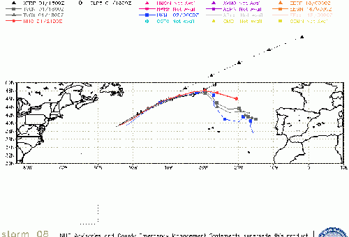
Elsewhere, Franklin is still forecast to become a hurricane and quite possibly a Major, coming in too close for comfort for Bermuda.
2:00 PM EDT 23 August 2023 Update
Conditions for development and even redevelopment in the Atlantic basin remain favorable.
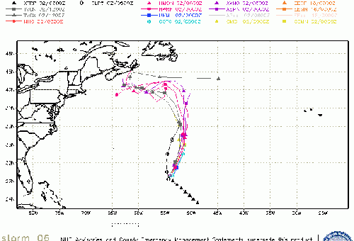
Tropical Storm Franklin made landfall this morning along the southern coast of the Dominican Republic and has been tracking over Hispaniola. Frankllin is more likely than not to survive this encounter with the mountainous terrain and then avail itself of a better environment for intensification. Interests from the Bahamas to Bermuda are at risk, with Bermuda potentially being impacted by a then-hurricane Franklin, perhaps even Major, by the early part of next week.
As conditions for not only development but redevelopment are good, Emily is now more likely than not to become a tropical cyclone (storm and perhaps hurricane) this week,and maybe ultimately brining strong winds and weather to the UK after merging with a non-tropical system in the north Atlantic.
Perhaps of more immediate interest to those of us from the Yucatan to Florida is the potential for development later this week from an area of low pressure in the eastern Pacific that is breaking off to cross over central America. We have started a Lounge on this 93L Lounge
10:00 AM CDT 22 August 2023 Update
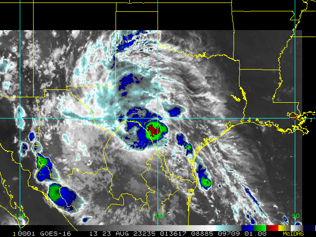
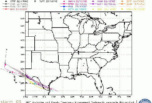
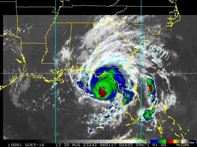
NINE became Tropical Storm Harold overnight and made a first landfall on the barrier island Padre in S TX about 10:00AM CT. Shortly before landfall Harold passed directly over Buoy 42020 which measured a pressure fall to about 995.5hPa.
According to Dr. Philip Klotzbach, since records have been kept only six other years have seen nine or more named storms by this date: 1936, 1995, 2005, 2011, 2012, and 2020.
Original Update
So far in 2023 all of the Atlantic basin storms have missed the U.S. and not many had a tropical storm in Southern California on their 2023 Bingo card. But now things have changed, and on Tuesday soon-to-be-Harold in the Gulf is set to make landfall in Texas while Franklin in the Caribbean impacts Puerto Rico.
NINE (likely Harold-to-be) has just enough time given the favorably low shear and high ocean heat content to avail itself, and may come ashore stronger than initially forecast and much stronger than people expect, so bears paying close attention to. Franklin could reform further east, downshear and in its deeper convection, putting Puerto Rico under more of its worst weather.
Beyond these two, there are some model suggestions that other US Atlantic-side impacting systems could to be on the way with a window open for a while, but too soon to point to any sure bets just yet.
Related Forecast Lounges:
Harold Lounge Franklin Lounge
Invest 93L Event Related Links
SFWMD Model Plot (Animated Model Plot) SFWMD Hurricane Page
[https://flhurricane.com/floatanimator.php?year=2023&storm=11 Flhurricane Satellite Floater Animation of 93L
GOES Floater
Animated Model Plot of 93L
Clark Evans Track Model Plot of 93L
(Animated!) Model Plots in Google Earth - In Google Maps
Clark Evans Intensity Model Plot of 93L (Animated!)
Clark Evans Track Plot of 93L
Other Model Charts from Clark
Clark Evans Top 10 Analog Storms for 93L
More model runs on from RAL/Jonathan Vigh's page
NRL Info on 93L -- RAMMB Info
COD Atlantic Satellite View
Harold Event Related Links
SFWMD Model Plot (Animated Model Plot) SFWMD Hurricane Page
[https://flhurricane.com/floatanimator.php?year=2023&storm=9 Flhurricane Satellite Floater Animation of Harold
GOES Floater
Animated Model Plot of Harold
Clark Evans Track Model Plot of Harold
(Animated!) Model Plots in Google Earth - In Google Maps
Clark Evans Intensity Model Plot of Harold (Animated!)
Clark Evans Track Plot of Harold
Other Model Charts from Clark
Clark Evans Top 10 Analog Storms for Harold
More model runs on from RAL/Jonathan Vigh's page
NRL Info on Harold -- RAMMB Info
COD Atlantic Satellite View
Franklin Event Related Links
SFWMD Model Plot (Animated Model Plot) SFWMD Hurricane Page
[https://flhurricane.com/floatanimator.php?year=2023&storm=8 Flhurricane Satellite Floater Animation of Franklin
GOES Floater
Animated Model Plot of Franklin
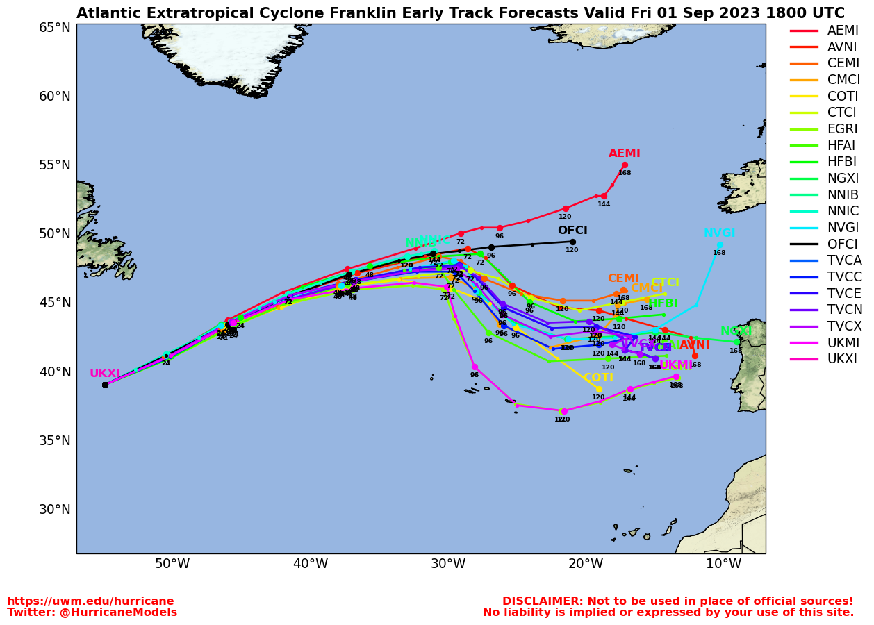
Clark Evans Track Model Plot of Franklin
(Animated!) Model Plots in Google Earth - In Google Maps
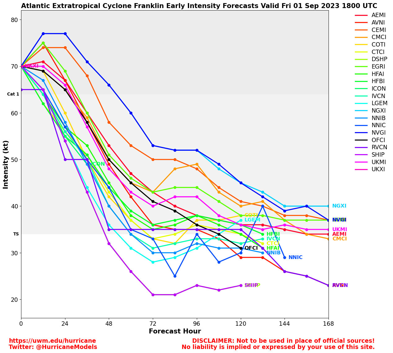
Clark Evans Intensity Model Plot of Franklin (Animated!)
Clark Evans Track Plot of Franklin
Other Model Charts from Clark
Clark Evans Top 10 Analog Storms for Franklin
More model runs on from RAL/Jonathan Vigh's page
NRL Info on Franklin -- RAMMB Info
COD Atlantic Satellite View
Gert Event Related Links
SFWMD Model Plot (Animated Model Plot) SFWMD Hurricane Page
[https://flhurricane.com/floatanimator.php?year=2023&storm=6 Flhurricane Satellite Floater Animation of Gert
GOES Floater
Animated Model Plot of Gert
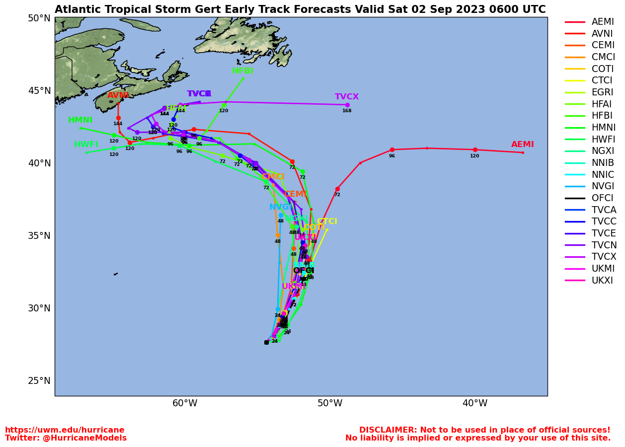
Clark Evans Track Model Plot of Gert
(Animated!) Model Plots in Google Earth - In Google Maps
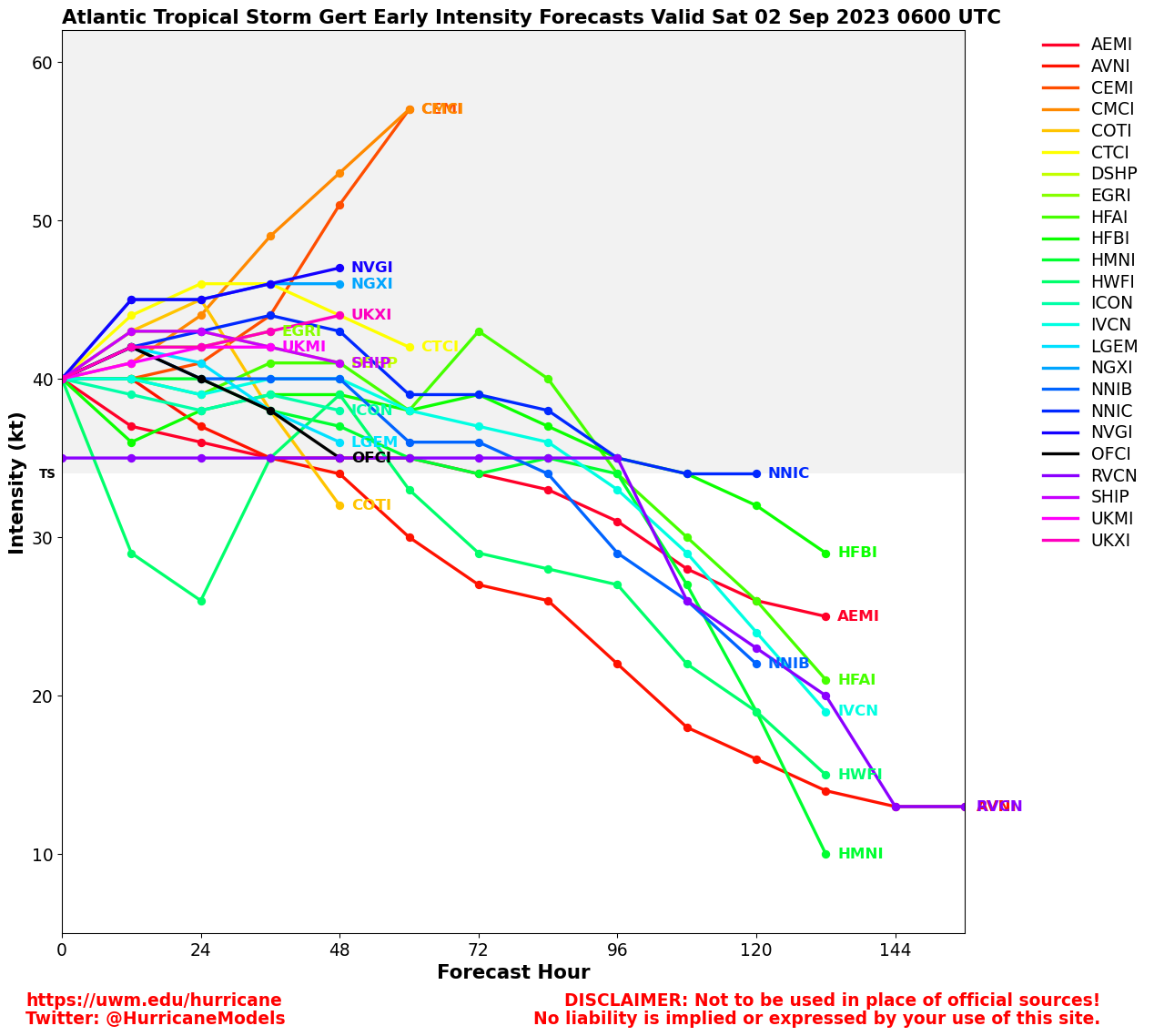
Clark Evans Intensity Model Plot of Gert (Animated!)
Clark Evans Track Plot of Gert
Other Model Charts from Clark
Clark Evans Top 10 Analog Storms for Gert
More model runs on from RAL/Jonathan Vigh's page
NRL Info on Gert -- RAMMB Info
COD Atlantic Satellite View
Invest 92L Event Related Links
SFWMD Model Plot (Animated Model Plot) SFWMD Hurricane Page
[https://flhurricane.com/floatanimator.php?year=2023&storm=10 Flhurricane Satellite Floater Animation of 92L
GOES Floater
Animated Model Plot of 92L
Clark Evans Track Model Plot of 92L
(Animated!) Model Plots in Google Earth - In Google Maps
Clark Evans Intensity Model Plot of 92L (Animated!)
Clark Evans Track Plot of 92L
Other Model Charts from Clark
Clark Evans Top 10 Analog Storms for 92L
More model runs on from RAL/Jonathan Vigh's page
NRL Info on 92L -- RAMMB Info
COD Atlantic Satellite View
StormCarib Reports from the Caribbean Islands
Caribbean Weather Observations
Barbados Brohav Weather Fax
Full Caribbean Radar Composite
Caribbean Broadcast Corporation (TV/Radio from Antilles)
San Juan, PR NWS Page
Various Caribbean Radio Stations
DR1 Dominican Republic Hurricanes
 Threaded


