11PM EDT 27 August 2023 Update
Idalia appears to be organizing at a breakneck pace tonight for what was, wind-wise at least, a "low end" tropical storm, and could very well be found to have become a hurricane by morning.
Floridians need to be aware that this cyclone has the potential to become one of those rare high-end hurricanes capable of producing serious devastation and loss of life, and take the necessary steps to protect life and property within the next day, as once conditions begin deteriorating, such precautions can be impossibly challenging to take.
Models are ingesting flight after flight of recon data now, and this should assist forecasters. We go into them in greater detail in the Idalia Forecast Lounge , which is also a good place to discuss pure informed speculation and best guesses as to Idalia's future.
5PM EDT 27 August 2023 Update
A Hurricane Watch has been issued for the Gulf coast of Florida
from Englewood to Indian Pass, including Tampa Bay.
A Storm Surge Watch has been issued for the Gulf coast of Florida
from Chokoloskee to Indian Pass, including Tampa Bay.
A Tropical Storm Watch has been issued for the Gulf coast of
Florida south of Englewood to Chokoloskee, and for the Dry Tortugas.
11:20AM EDT 27 August 2023 Update
TD#10 is Now Tropical Storm Idalia.
Update written immediately before special update to Idalia:
Landfall is forecast Wednesday somewhere along the Florida west coast as a Category 1 hurricane, those at and to the right of the landfall point are most likely to see the impacts, impacts may be felt well east of the cone. Note uncertainty for track and intensity is high, so further adjustments to the track and intensity in the future may occur. TD#10 may become Tropical Storm Idalia at any time later today. Recon aircraft is out there this morning to help improve the forecasts, but those along the West coast of Florida should use today to prepare as there's a sales tax holiday for hurricane supplies going on this week.
Especially for this angle of approach (Charley and Ian are the most recent examples, but this could go left or right), do not base on the track, even if the forecast track occurs exactly as is the Tampa area will still see impacts of some surge along the coast and heavy rainfall, so please do not focus on the exact forecast track, since strong winds, heavy rains and dangerous storm surges extend well away from the center. Since TD#10 is meandering this morning near Cozumel there's an extra bit of uncertainty, Movement away from the Yucatan Peninsula isn't expected until tomorrow.
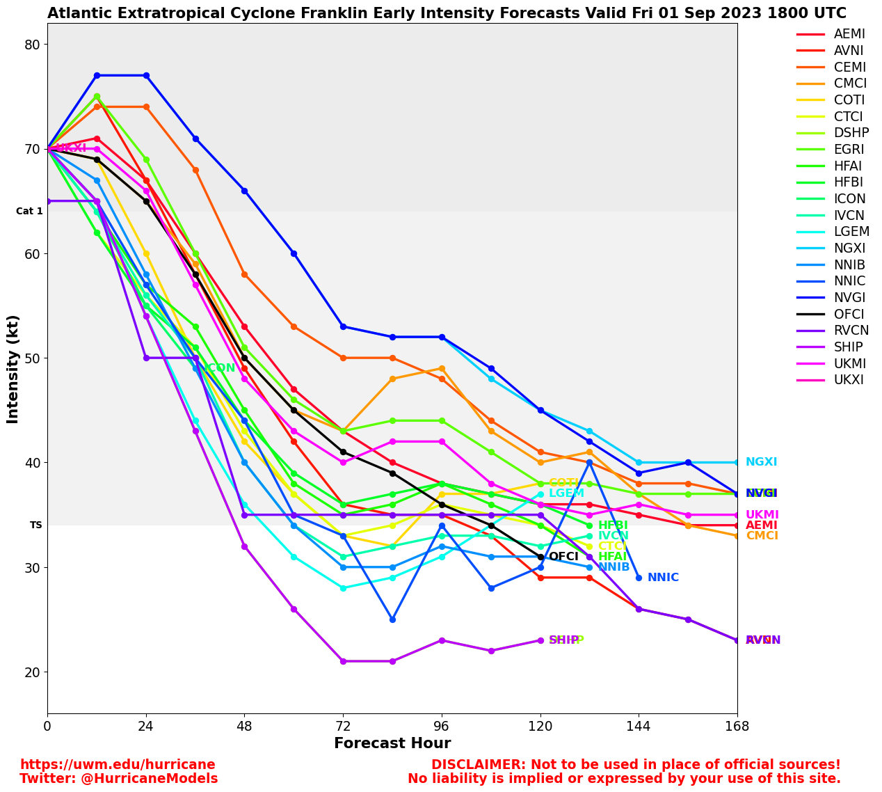
Bermuda should also watch Franklin in case the threat moves closer.
7:30AM EDT 27 August 2023 Update
Idalia-to-be (TD TEN) and Hurricane Franklin are being aggressively flown by recon today, and this invaluable data will be fed into the models, forecast models which have been especially struggling a bit with TEN, and forecasters too.
By the end of the day we should be able to have greater confidence in the forecasts, but this is not to say that impacts won't be felt. There is already high confidence that a then-hurricane Idalia will make landfall somewhere along the west coast of Florida, and that a then-Major Hurricane Franklin will be within striking distance of Bermuda.
4:30PM EDT 26 August 2023 Update
NHC Advisories are being issued TD TEN, Idalia-to-be
1:30PM EDT 26 August 2023 Update
For all practical intents and purposes, if not literally, Invest 93L is now a tropical cyclone just off the northeastern coast of the Yucatan. Unfortunately, we have had neither recon nor satellite wind data available to confirm this. It would be best to treat 93L as a compact tropical depression or storm and begin taking precautions for a landfalling northeastern Gulf of Mexico TC, and potentially a very strong one.
Governor Desantis has declared a precautionary State of Emergency for 33 Florida counties. The counties included are: Alachua, Bay, Calhoun, Charlotte, Citrus, Columbia, DeSoto, Dixie, Franklin, Gadsden, Gilchrist, Gulf, Hamilton, Hardee, Hernando, Hillsborough, Jefferson, Lafayette, Lee, Leon, Levy, Liberty, Madison, Manatee, Marion, Pasco, Pinellas, Polk, Sarasota, Sumter, Suwannee, Taylor, and Wakulla.
Original Update
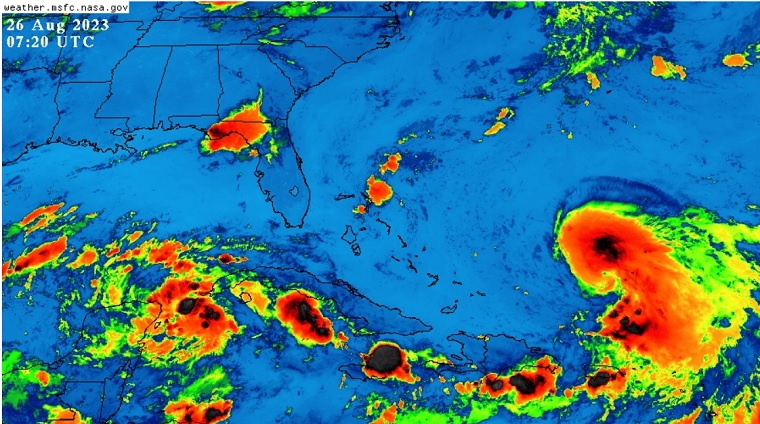
Left: Invest 93L (Likely Idalia-to-be) and Right: Franklin
INVEST 93L
The disturbance in the northwestern Yucatan continues to organize and as of this update is getting much more of the "look and feel" of a bona fide tropical cyclone. development odds as of 2:00AM ET are up to 60%/90%, possibly conservative, and Watches and Warnings for a verified or Potential Tropical Cyclone could be issued at any time this weekend.
Conditions for further development and intensification of both Invest 93L (almost certainly Idalia-to-be) and Tropical Storm Franklin are favorable to very favorable. Sea surface temperatures are exceptionally supportive, shear is modest to light, the air moist, and the season is about peak.
The next name on the list is Idalia (Pronounced ee-DAL-ya).
The Lounge on 93L is up and regularly updating: Idalia Forecast Lounge
Tropical Storm Franklin
Franklin recently jumped a bit northeastward into deeper convection and thus right of forecast position. With this, has updated the cone a little to the east of the last advisory, and on this track Franklin will likely sideswipe Bermuda from the west sometime between Sunday night and Monday (timing differences between models).
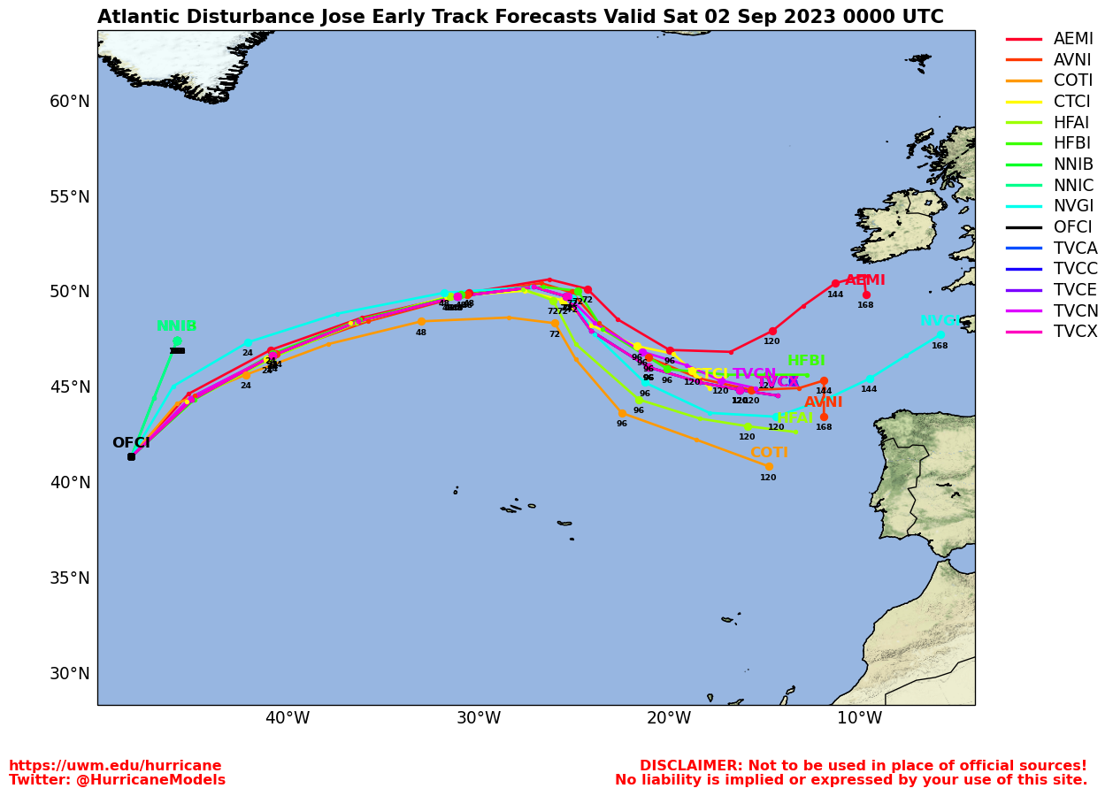
Elsewhere, we continue to monitor a few other areas in the central to eastern Tropical Atlantic, most of which would be incline to head poleward.
Idalia Event Related Links
SFWMD Model Plot (Animated Model Plot) SFWMD Hurricane Page
[https://flhurricane.com/floatanimator.php?year=2023&storm=10 Flhurricane Satellite Floater Animation of Idalia
GOES Floater
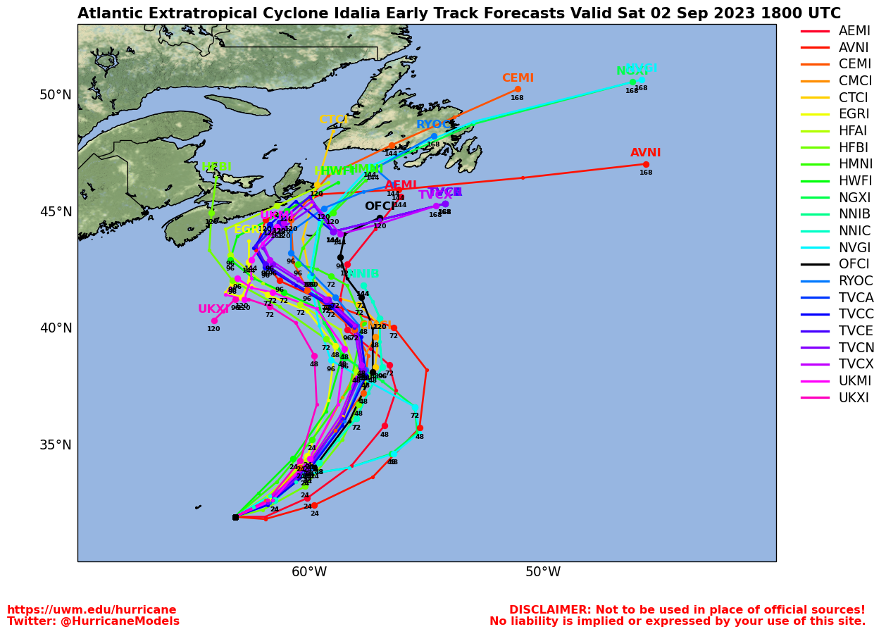
Animated Model Plot of Idalia
Clark Evans Track Model Plot of Idalia
(Animated!) Model Plots in Google Earth - In Google Maps
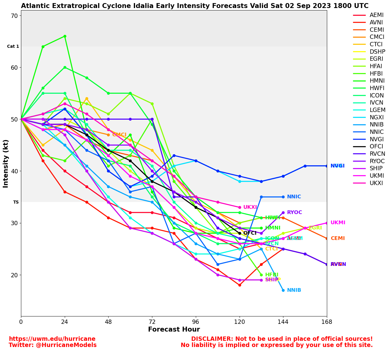
Clark Evans Intensity Model Plot of Idalia (Animated!)
Clark Evans Track Plot of Idalia
Other Model Charts from Clark
Clark Evans Top 10 Analog Storms for Idalia
More model runs on from RAL/Jonathan Vigh's page
NRL Info on Idalia -- RAMMB Info
COD Atlantic Satellite View
Franklin Event Related Links
SFWMD Model Plot (Animated Model Plot) SFWMD Hurricane Page
[https://flhurricane.com/floatanimator.php?year=2023&storm=8 Flhurricane Satellite Floater Animation of Franklin
GOES Floater
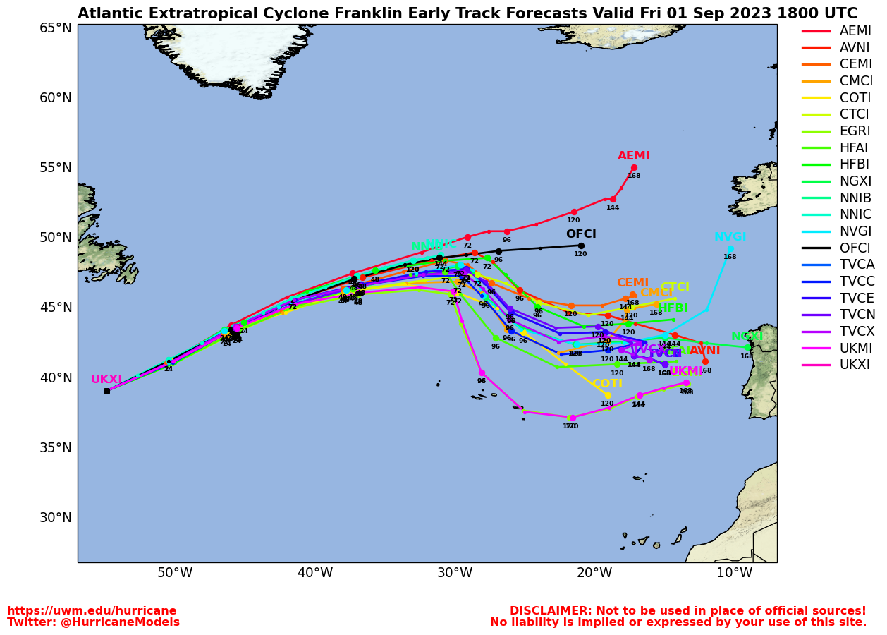
Animated Model Plot of Franklin
Clark Evans Track Model Plot of Franklin
(Animated!) Model Plots in Google Earth - In Google Maps
Clark Evans Intensity Model Plot of Franklin (Animated!)
Clark Evans Track Plot of Franklin
Other Model Charts from Clark
Clark Evans Top 10 Analog Storms for Franklin
More model runs on from RAL/Jonathan Vigh's page
NRL Info on Franklin -- RAMMB Info
COD Atlantic Satellite View
Gert Event Related Links
SFWMD Model Plot (Animated Model Plot) SFWMD Hurricane Page
[https://flhurricane.com/floatanimator.php?year=2023&storm=6 Flhurricane Satellite Floater Animation of Gert
GOES Floater
Animated Model Plot of Gert
Clark Evans Track Model Plot of Gert
(Animated!) Model Plots in Google Earth - In Google Maps
Clark Evans Intensity Model Plot of Gert (Animated!)
Clark Evans Track Plot of Gert
Other Model Charts from Clark
Clark Evans Top 10 Analog Storms for Gert
More model runs on from RAL/Jonathan Vigh's page
NRL Info on Gert -- RAMMB Info
COD Atlantic Satellite View
Invest 92L Event Related Links
SFWMD Model Plot (Animated Model Plot) SFWMD Hurricane Page
[https://flhurricane.com/floatanimator.php?year=2023&storm=11 Flhurricane Satellite Floater Animation of 92L
GOES Floater
Animated Model Plot of 92L
Clark Evans Track Model Plot of 92L
(Animated!) Model Plots in Google Earth - In Google Maps
Clark Evans Intensity Model Plot of 92L (Animated!)
Clark Evans Track Plot of 92L
Other Model Charts from Clark
Clark Evans Top 10 Analog Storms for 92L
More model runs on from RAL/Jonathan Vigh's page
NRL Info on 92L -- RAMMB Info
COD Atlantic Satellite View
Tampa Area Media:
Bay News 9
WFLA News 8 (NBC)
Bay Action News (ABC)
WTSP Channel 10 (CBS)
My Fox Tampa Bay
WWSB ABC 7 Sarasota
Tampa Bay Times
Tampa Bay Online
Sarasota Herald Tribune
970 WFLA Tampa News/Talk Radio
Florida Panhandle Media/Links
WJHG TV 7 (NBC) Panama City Beach, FL
WMBB TV 13 (ABC) Panama City Beach, FL / My Panhandle
WCTV 6 (CBS) Tallahassee, FL
WTXL 27 (ABC) Tallahassee, FL
WTWC-DT2 49 (Fox) Tallahassee, FL
WTWC 40 (NBC) Tallahassee, FL
WEAR TV 3 (ABC) Pensacola, FL
Newspapers
Panama City Beach News Herald
Tallahassee Democrat
Radio (some)
News Talk 94.5 WFLA Panama City Beach
]https://wflafm.iheart.com/ 100.7 WFLA News Radio Tallahassee, FL]
Power Outage
Florida Power Outage Map
Alabama Power Outage Map
Southwest Florida (Naples/Ft.Myers) Area Media:
WINK News 11 Fort Myers CBS
WBBH NBC 2 Fort Myers NBC
ABC 7 Naples ABC
FOX 4 Florida Cape Coral FOX
WFSX Fox 92.5 News Radio
WCCF News Radio 1580 Port Charlotte
News Press
Naples Daily News
Northeast Gulf Links
Southeast Composite Radar Loop
(Latest Static)
Tampa Bay, FL Radar Radar Loop
(Latest Static)
Key West, FL Radar Radar Loop
(Latest Static)
Mobile, AL Radar Radar Loop
(Latest Static)
Tallahassee FL Radar Radar Loop
(Latest Static)
Northwest Florida Radar Radar Loop
(Latest Static)
Gulf of Mexico Satellite Imagery
SFWMD Full Florida Radar (Includes east LA, MS,AL) Loop with Storm Track
Area Forecast Discussions:
New Orleans -
Mississippi/Alabama/Pensacola -
Panhandle/Tallahassee -
Tampa/West Central Florida
Bermuda Newspapers/Media:
BerNews
Royal Gazette (Bermuda)
Bermuda Sun
Hott 107.5 Bermuda Radio
Storm Carib Bermuda Reports
Bermuda Weather Service
 Threaded


