cieldumort
Moderator

Reged: Mon
Posts: 2305
Loc: Austin, Tx
|
|
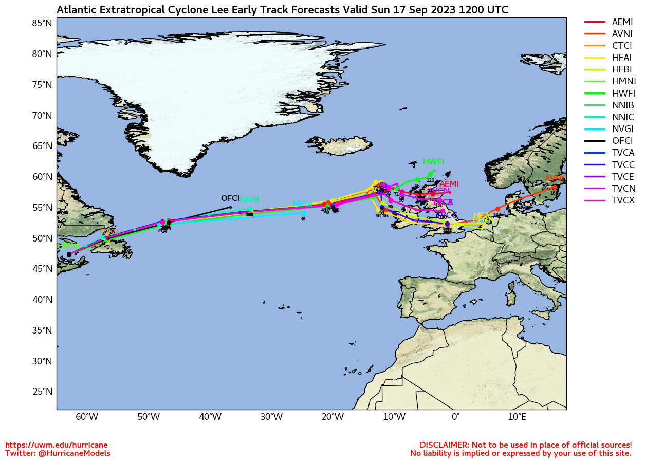
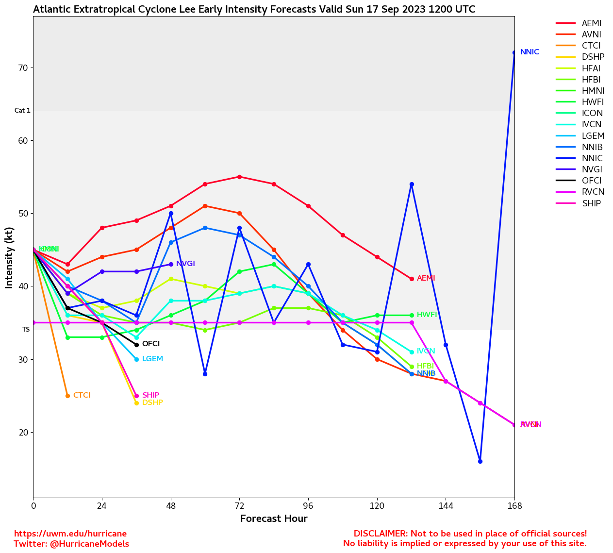
Update 7:30AM EDT 15 September 2023 Update
Lee, now a large category 1 hurricane has passed by Bermuda. It's large windfield gave Bermuda some ( 11,746) power outages and rather strong tropical storm force winds as it passed. There are still winds being reported there as it heads north. The hurricane watch has shrank to be less of Maine as the track has honed in on the Bay of Fundy, Western Nova Scotia and Coastal New Brunswick in Canada. The large windfield will likely drive some water up along the coasts,
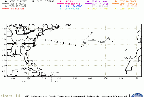
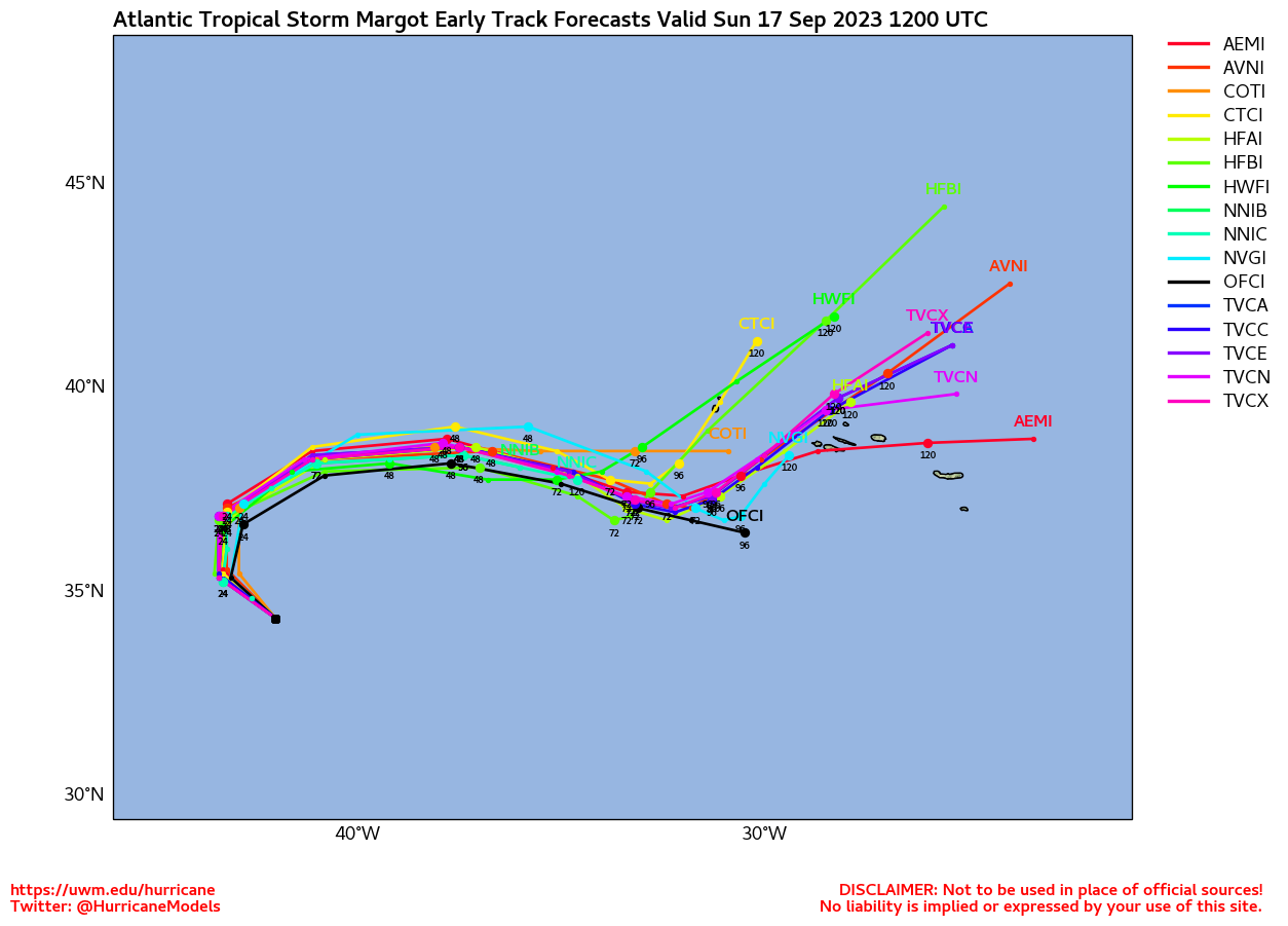
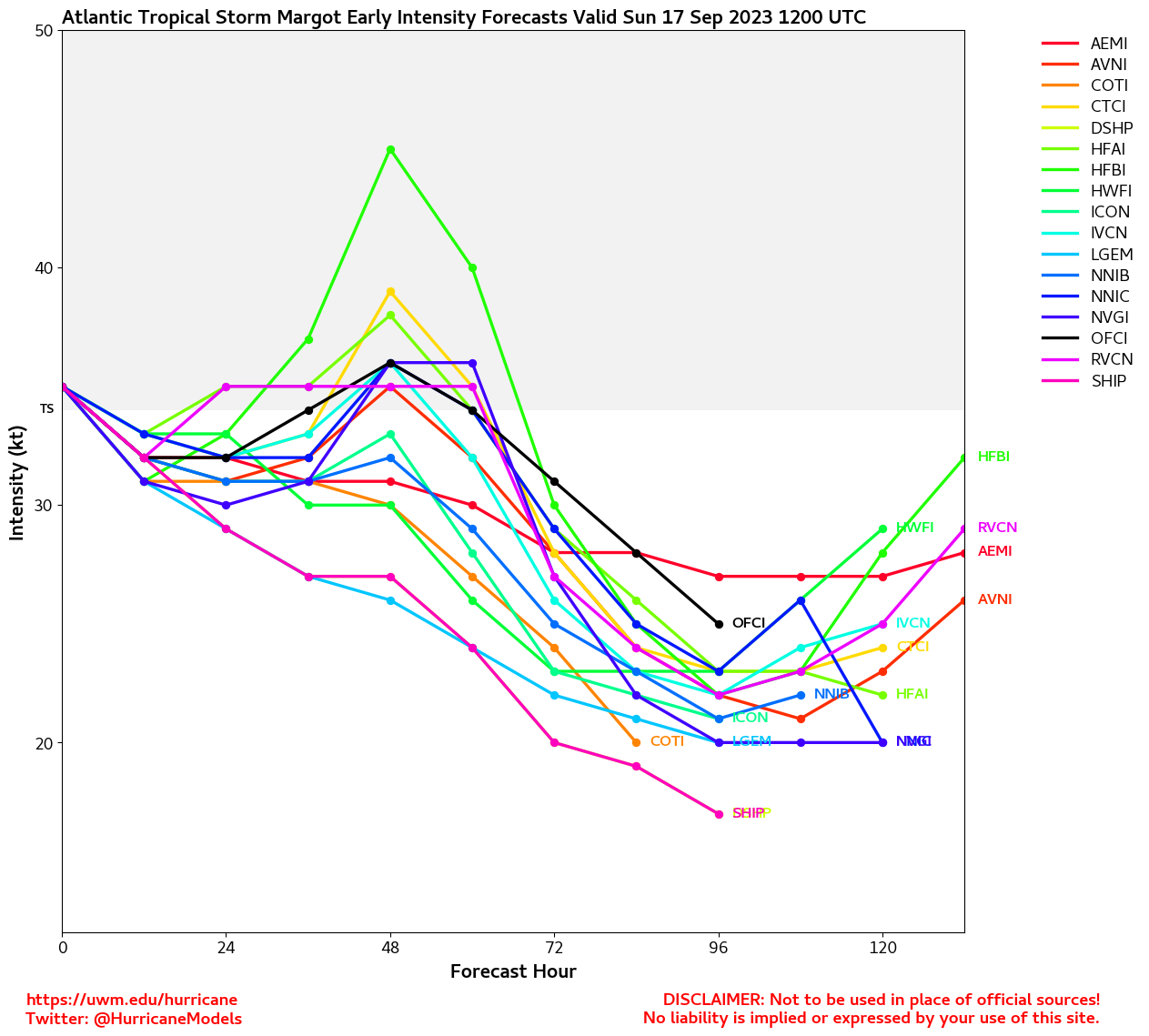
Margot still meandering is the open atlantic and Invest 97L is likely to form today in the Atlantic with a 90% chance to develop, but is expected to stay out to sea.
Update 7:30AM EDT 13 September 2023 Update
Hurricane Lee likely has reached its peak intensity, however the size has grown (larger than the 's wind probability graphic allows, which they call out in the discussion). Tropical Storm Warnings are up for Bermuda, and it's likely they will see them tomorrow through Friday. By Friday night, some areas of the Northeastern US will likely see the winds, and by Saturday the closest approach to the Cape Cod is expected to happen midday which corresponds with higher tides for MA/NH and parts of Maine. Surge will likely be an issue in much of the area (New England and Canada) in some places where the winds are onshore (southern part of Cape Cod Bay) coast and some of the rivers along coastal New Hampshire/Maine. The system itself will be weakening as it gets roughly north of New Jersey's latitude due to much colder waters, but still pack a punch. Watches for part of the Northeast and Canada may come later today or tomorrow.
Elsewhere the 80% area (97/98L) has an 80% chance to develop with plenty of ocean ahead to hopefully stay out to sea with.
Update 7:30AM EDT 12 September 2023 Update
Hurricane Lee has grown in size since yesterday and has a much larger eye and windfield. Meaning intensity has remained roughly the same with 115mph winds but the area of strong winds has increased.
Bermuda could see watches later today, and those in New England, coastal New Brunswick, and Nova Scotia are in the cone. The rest of the east coast will see dangerous surf along the beaches.
New England and Atlantic Canada should watch Lee closely, Maine or Nova Scota is the most likely landfall area, but the large size of Lee will have effects for a much larger area, all those in the cone (including Cape Cod and coastal New Hampshire) and near it should pay close attention to Lee as the turn north is forecast to happen sometime tomorrow, with affects in the Northeast starting Friday night.
Update 7:30PM EDT 11 September 2023 Update
Hurricane Lee is back to Major Hurricane Strength, and the turn is forecast for Wednesday followed by a pass by west of Bermuda. Beyond this parts of New England and Atlantic Canada are entering the cone. Those in New England and New Brunswick along the coast, and Nova Scotia should watch the progress of lee closely. The models suggest a slight bump west due to ridging as it nears Maine or Nova Scotia that could bring strong winds and storm surge to parts of Massachusetts, New Hampshire, and Maine, as well as Nova Scotia and the Bay of Fundy.
The east coast of the US and Islands near Lee will likely see rough surf and rip currents even though Lee is well east most of the week.
Tropical Storm Watches may go up for Bermuda tomorrow.
Update 8:30AM EDT 10 September 2023 Update
Lee weakened yesterday back to a category 2 hurricane, but is forecast to regain major strength over the next few days. Expected turn is still around Wednesday approximately around 68 West longitude. Timing of the turn will impact the eventual track as well as the poiitions of Margot and 97L for both Bermuda and the northeast and Canada. The spread is still fairly wide so the potential track space is effectively still the North Carolina Outer Banks all the way north and east to Out to Sea, with the most likely being around Nova Scotia in Canada. So it's important to watch all along there, but just monitoring.
Update 9:30PM EDT 9 September 2023 Update
Shear and an apparent Eyewall Replacement Cycle have conspired to hinder Lee's attempts to re-intensify so far this weekend and this may go on for yet a little bit longer than models keep, erroneously, forecasting. However, at some point this shear will still likely start to lessen, possibly as soon as later overnight tonight, and the should complete. After that time, Rapid Intensification will again become possible, if not likely, and Lee could once again become a strong Category 4 or 5 hurricane.
Elsewhere, Tropical Storm Margot is spinning fish, but the Azores might want to keep watch. To Margot's southwest, we now have yet another Cabo Verde tropical low way out in the Tropical Atlantic that already looks to be on the cusp, Invest 97L, and yet another wave right behind it.
It is not yet clear which of these two has the better chance of being named, although 97L does have the running start and already a closed or nearly closed circulation. Despite low opening odds for classification, models are already warming up to 97L, and with the record of disturbances developing recently, we're only making plans for Nigel.
Update 7:30AM EDT 9 September 2023 Update
Lee weakened a bit yesterday but remains a major hurricane and is showing signs of gradual restrengthening this morning. Parts of the leeward islands of the Caribbean's north shores are being affected very strong rip currents, and they will spread west over the next few days. The turn north is now part of the official forecast, as it looks to stay safely away from the Bahamas and most of the US East coast. High surf is likely the only impact that may start to show up Monday or so.
Those in Bermuda, however need to watch Lee closely as it may get close enough for some stronger affects, even if not the worst part of the storm. Beyond this it's still soon to say, but the most likely areas to potentially be impacted is Atlantic Canada, and there's a chance the storm may stay entirely out to sea. If it does make it up to Canada it will be much weaker at this time. Although there's still a possibility of New England impacts, chances for that are becoming less likely. As always, with hurricanes this far out, continue to monitor for changes anywhere along the east coast as beyond 5 days or so things are much more subject to change.
Update 10:15AM EDT 8 September 2023 Update
Recon continues to find shear banging on Lee from the southwest, with pressures rising considerably and maximum sustained winds coming down. Should this trend continue there may be some unexpected influence to track, but overall, not yet nearly weak enough to suggest an appreciably more westward course.
18z and 0z model runs tonight should be taking these findings from recon into consideration.
Update 7:30AM EDT 8 September 2023 Update
Lee has held itself overnight and fought a bit of shear, but remains a category 5 hurricane this morning. The storm is forecast to move well north of the Caribbean, but high surf impacts to the north side of the islands will likely start to show up tonight. Beyond this, longer range models show a gradual slowdown in forward speed and a turn to the north well east of the Bahamas and Southeast US.
Those in Bermuda will want to watch closely, and the Mid Atlantic, New England, and especially Atlantic Canada will also want to watch later on. However high surf, beach erosion, and rip currents are likely to start showing up either late this weekend or early to mid next week along parts of the Bahamas and US coasts.
With Margot also entering the central Atlantic there is very high uncertainty in the track and large swings in the models run to run beyond 7 days or so, so monitoring is recommended.
Update 11PM EDT 7 September 2023 Update
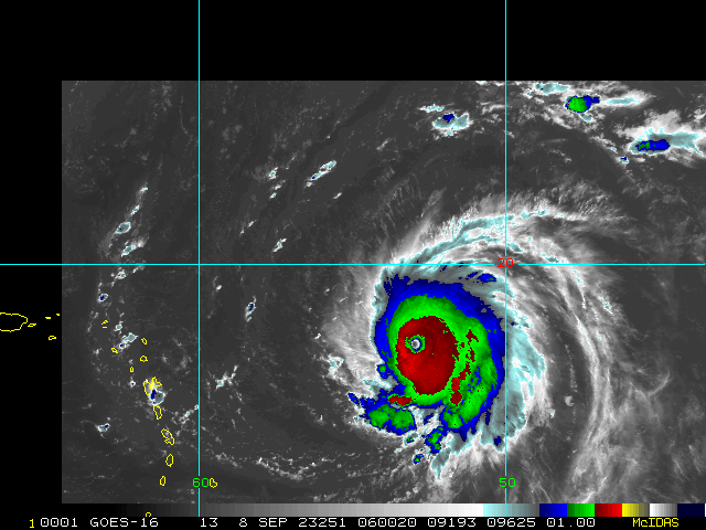
Lee has continued to undergo Rapid Intensification at a breakneck pace tonight and is now a Category Five hurricane. The speed at which it accomplished this is incredibly rare for the Main Development Region.
The updated forecast now explicitly calls for Lee to reach 180 MPH. According to Dr. Klotzbach, just seven Atlantic hurricanes in the satellite era (more reliable record keeping) have achieved this. They are Allen (1980), Gilbert (1988), Mitch (1998), (2005), (2005), Irma (2017) and Dorian (2019).
NHC even went one further to add in their 11PM discussionQuote:
Amazingly, the 1800 UTC HAFS-A and -B runs show a peak intensity between 170-180 kt, but that's getting into rarefied air. The forecast will be adjusted accordingly if those solutions begin looking like a more distinct possibility.
Update 11AM EDT 7 September 2023 Update
Lee is now a category 2 hurricane and forecast to become a category 5 hurricane, but stay north of the Caribbean islands as it does so. Beyond this it is generally expected to make a turn north and away from the Bahamas and Southeast US, but it is still worth watching north of there particularly for Bermuda and the outer banks and north particularly for the high swells and waves this system will likely generate
Recon will be out in Lee later today.
Tropical Depression Fourteen also formed in the east Atlantic, and is expected to become a hurricane, next name is Margot. Likely to stay far away from land areas, but the Azores may want to monitor it.
Update 7AM EDT 6 September 2023 Update
Tropical Storm Lee is well on its way to hurricane strength this morning, and likely to become a hurricane later today. It's current forecast track keeps it north of the Caribbean islands, but as it gets closer to this general area it is expected to become a very intense major hurricane. Even though the forecast has no direct landfall impacts, the size and strength of the storm will make north facing shores have extremely rough surf and waves, and if it stays on the left side of the cone the islands still could see more impact. Once beyond the Caribbean the most likely track keeps it away from the Southeastern US, however confidence in models beyond 5 days is fairly low. Those along the East Coast (including Canada) , Bahamas and Bermuda will want to monitor the progression of Lee. Because large swells, rough surf and rip currents are likely even if it stays east down the road.
Another area east of lee has a 70% to develop, but is likely to stay out to sea.
Update 5PM EDT 5 September 2023
THIRTEEN has continued to organize and has become Tropical Storm Lee. Interests in the Lesser Antilles may want to begin paying close attention to forecasts and taking some initial preparations for the impacts of a nearby Major Hurricane, as Lee could well be a 3, 4, or even 5 at that time.
From Quote:
KEY MESSAGES:
1. Lee is forecast to become a major hurricane by this weekend and
could bring impacts to the Leeward Islands by that time. While it
is too soon to determine the location and magnitude of these
possible impacts, interests in this area should monitor the
progress of Lee and further updates to the forecast.
FORECAST POSITIONS AND MAX WINDS
INIT 05/2100Z 13.2N 41.8W 40 KT 45 MPH
12H 06/0600Z 13.7N 43.7W 50 KT 60 MPH
24H 06/1800Z 14.4N 46.2W 60 KT 70 MPH
36H 07/0600Z 15.2N 48.5W 70 KT 80 MPH
48H 07/1800Z 16.2N 51.0W 80 KT 90 MPH
60H 08/0600Z 17.2N 53.6W 90 KT 105 MPH
72H 08/1800Z 18.3N 56.0W 110 KT 125 MPH
96H 09/1800Z 20.4N 60.5W 120 KT 140 MPH
120H 10/1800Z 22.2N 64.3W 125 KT 145 MPH
And honestly, these forecast windspeeds could be conservative.
Update 10:15AM EDT 5 September 2023
NHC is initiating advisories on THIRTEEN in the Tropical Atlantic (95L).
TD 13 should be named soon as well. The next name on the list is Lee.
Original update
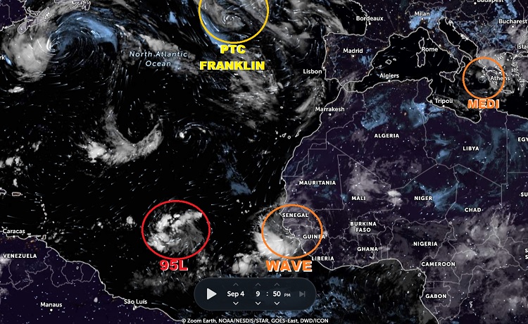
Base image credit: Zoom Earth
2023 has been anything but a usual El Niño, with both the Atlantic and Eastern Pacific basins doing very impressive things.
As of this update, the Atlantic basin stands at 12 Storms, 3 Hurricanes and 2 Majors. It's not even September 10th and the basin has nearly reached NOAA's preseason forecast of 12-17 Storms, 5-9 Hurricanes and 1-4 Majors. The East Pac has reached 9 Storms, 6 Hurricanes and 4 Majors, getting close to NOAA's preseason outlook for its entire season of 14-20 Storms, 7-11 Hurricanes and 4-8 Majors.
Especially impressive were Hurricane Hilary in the East Pac, making meteorological history by becoming the first Tropical Storm landfall along Southern California since 1939, and Hurricane Idalia in the Atlantic, which was the strongest hurricane to make landfall in the Big Bend region since the Cedar Key Hurricane of 1896.
These two names are behind us now, but the 2023 seasons are not. SSTs in both the Atlantic and East Pac are running well above average, with tropical cyclone supportive warmth extending well beyond what prior to the past few decades might be considered "in the basin," and as of tonight there are three areas we are watching in the Atlantic: One in the east-central Tropical Atlantic Main Development Region: 95L. One in the far eastern Atlantic (likely to be assigned 96L this week), and believe it or not, the post-tropical low pressure of Hurricane Franklin is making a run at regeneration west of Portugal and Spain while a ferociously wet-weather-producing hybrid cyclone and potential future Medicane spins up in the Mediterranean Sea, south-southwest of Greece.
Of most interest and concern to those of us left of the 55th meridian west, is the soon-to-be-Lee that is currently Invest 95L.
Making no bones about it, Invest 95L, the exceptionally well-structured tropical wave in the far eastern Atlantic, is likely to become a Major Hurricane within the next seven days, and the models are on to this. They've got Lee's number, and collectively most of them say it is somewhere from 3 and 5, even before the disturbance has been given his name!
This incipient cyclone has all the makings of a social media freakout storm long before we all really know where it is going. That said, there are some outlier runs that all but explicitly call for a southeast to east coast impact, and perhaps more importantly, there are also legit meteorological reasons why the models largely now forecasting recurvature might be missing a few things.
Fortunately, we have lots of time to watch and learn a lot about this one, and should. Recon will likely begin flying in later this week and the information they collect will be invaluable.
TD 13/Lee model talk:
Lee Lounge
Storm Daniel Updates:
Mediterranean Storm Daniel
97L Model talk:
97L Lounge
Lee Event Related Links
SFWMD Model Plot (Animated Model Plot) SFWMD Hurricane Page
[https://flhurricane.com/floatanimator.php?year=2023&storm=13 Flhurricane Satellite Floater Animation of Lee
GOES Floater
Animated Model Plot of Lee
Clark Evans Track Model Plot of Lee
(Animated!) Model Plots in Google Earth - In Google Maps
Clark Evans Intensity Model Plot of Lee (Animated!)
Clark Evans Track Plot of Lee
Other Model Charts from Clark
Clark Evans Top 10 Analog Storms for Lee
More model runs on from RAL/Jonathan Vigh's page
NRL Info on Lee -- RAMMB Info
COD Atlantic Satellite View
Margot Event Related Links
SFWMD Model Plot (Animated Model Plot) SFWMD Hurricane Page
[https://flhurricane.com/floatanimator.php?year=2023&storm=14 Flhurricane Satellite Floater Animation of Margot
GOES Floater
Animated Model Plot of Margot
Clark Evans Track Model Plot of Margot
(Animated!) Model Plots in Google Earth - In Google Maps
Clark Evans Intensity Model Plot of Margot (Animated!)
Clark Evans Track Plot of Margot
Other Model Charts from Clark
Clark Evans Top 10 Analog Storms for Margot
More model runs on from RAL/Jonathan Vigh's page
NRL Info on Margot -- RAMMB Info
COD Atlantic Satellite View
Nigel Event Related Links
SFWMD Model Plot (Animated Model Plot) SFWMD Hurricane Page
[https://flhurricane.com/floatanimator.php?year=2023&storm=15 Flhurricane Satellite Floater Animation of Nigel
GOES Floater
Animated Model Plot of Nigel
Clark Evans Track Model Plot of Nigel
(Animated!) Model Plots in Google Earth - In Google Maps
Clark Evans Intensity Model Plot of Nigel (Animated!)
Clark Evans Track Plot of Nigel
Other Model Charts from Clark
Clark Evans Top 10 Analog Storms for Nigel
More model runs on from RAL/Jonathan Vigh's page
NRL Info on Nigel -- RAMMB Info
COD Atlantic Satellite View
StormCarib Reports from the Caribbean Islands
Caribbean Weather Observations
Barbados Brohav Weather Fax
Full Caribbean Radar Composite
Caribbean Broadcast Corporation (TV/Radio from Antilles)
San Juan, PR NWS Page
Various Caribbean Radio Stations
DR1 Dominican Republic Hurricanes
Bermuda Newspapers/Media:
BerNews
Royal Gazette (Bermuda)
Bermuda Sun
Hott 107.5 Bermuda Radio
Storm Carib Bermuda Reports
Bermuda Weather Service
Edited by MikeC (Sun Sep 17 2023 07:11 AM)
|
MikeC
Admin
Reged: Sun
Posts: 4543
Loc: Orlando, FL
|
|
recon finding 928mb extrap with 140knot (160mph) flight level winds. Probably a mid-high cat 4 at surface.
|
cieldumort
Moderator
Reged: Mon
Posts: 2305
Loc: Austin, Tx
|
|
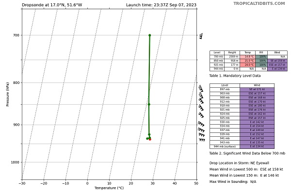
Powerhouse mean wind speed in the lowest 150m of the NE eyewall.
Between this and reliable SFMR above 140 KTS suggests Lee might be Cat 5 already, tho I would like to see a little more before biting.
|
cieldumort
Moderator
Reged: Mon
Posts: 2305
Loc: Austin, Tx
|
|
|
cieldumort
Moderator
Reged: Mon
Posts: 2305
Loc: Austin, Tx
|
|
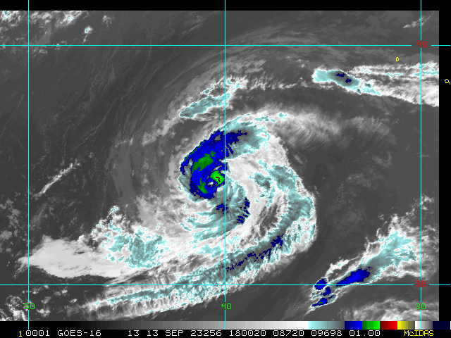
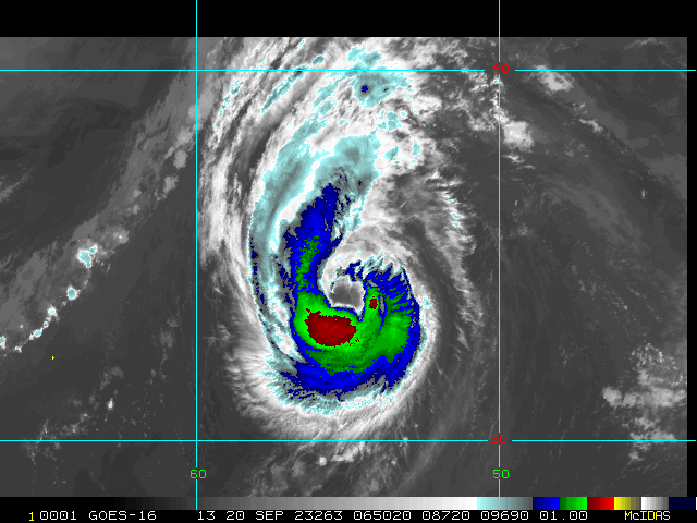
Lee appears to be encountering some shear overnight out of the southwest. This is easily made out in all IR and WV channels, with CIMSS analyzing about 17 knots southwesterly, and assigning just a neutral shear environment for further intensification.
Last recon pass through the NE eyewall found probably reliable SFMRs of up to 158 KTS with an averaging that could argue for 145-150 KTS sustained at the surface, along with some possible weakening of winds at higher altitudes.
|
MikeC
Admin
Reged: Sun
Posts: 4543
Loc: Orlando, FL
|
|
Lee has hit a bit of shear that really wasn't shown by the models until recently, and it manifested on satellite by the eye becoming a lot less visible. it looks like it'll be a bit weaker today but has a chance to recover later tomorrow. My guess is today this size of Lee will expand and strengthening will resume tomorrow. Model confidence on a turn north is very strong, just differing on exactly when (Still well east of the Bahamas). Turn should start to be evident around 65W around Tuesday or Wednesday.
Track beyond the turn is anyone's guess as Margot will likely make it very difficult to trust.
|
MikeC
Admin
Reged: Sun
Posts: 4543
Loc: Orlando, FL
|
|
Surge estimates for Lee https://cera.coastalrisk.live/
|
|
 Threaded


