cieldumort
Moderator

Reged: Mon
Posts: 2305
Loc: Austin, Tx
|
|
6PM EDT Update 20 October
Recon is continuing frequent flights into Hurricane Tammy this weekend and this data will be fed into models to help fine-tune official forecasts. The cyclone has potential to strengthen more than currently forecast, and possibly track a bit west as well, and interests in the eastern Caribbean should continue to be prepared for substantial impacts from rain, flood, wind and surge.
Hurricane Season is not over, and waters are very warm this year. Elsewhere, we are also tracking Major Hurricane Norma in the East Pac, set to bring central US states copious rains next week after a direct hit on western Mexico, as well as a new area of low pressure in the southern Caribbean that could very well develop this weekend, and yet another disturbance east of the Caribbean.
Unlike much of the season, steering currents look to be shifting in a way that have the potential to send any tropical cyclones that form or get close enough towards the south to southeast United States.
11AM EDT Update 20 October
Now Hurricane Tammy is on a clear upswing today and may still track over or near the islands of the eastern Caribbean as a strong hurricane. Preps should be rushed to completion today.
12PM EDT Update 19 October
Recon has found Tammy stronger this morning, now a 60 MPH tropical storm, forecast to become a hurricane within 48 hours and before clearing the islands. Hurricane Watches are now starting to go up and will likely expand and be converted to hurricane warnings later today or tomorrow.
There is a chance that Tammy becomes a strong hurricane prior to clearing the islands. Either way, interests in the eastern Caribbean should now be preparing for strong tropical storm and/or hurricane conditions over the course of the next several days and starting as soon as tonight from east to west, then north.
SUMMARY OF WATCHES AND WARNINGS IN EFFECT:
A Hurricane Watch is in effect for...
* Guadeloupe
A Tropical Storm Warning is in effect for...
* Guadeloupe
A Tropical Storm Watch is in effect for...
* Barbados
* Dominica
* Martinique
* Antigua, Barbuda, Montserrat, St. Kitts, Nevis, Anguilla, and St. Barthelemy
* Saba and St. Eustatius
* St. Maarten
* St. Martin
11AM EDT Update 18 October
A stable low level circulation may finally be forming today with Invest 94L. Satellite derived wind data also shows winds are already at tropical storm force, and the system could be named as soon as later today. Interests in the eastern Caribbean may want to begin taking some preliminary steps to prepare for an indirect or direct hit, probably starting about Friday if the system does not recurve before then.
The next name on the list is Tammy.
8PM EDT Update 12 October
NHC odds on 94L developing are now up to 50% within 7 days. About a coin toss as to whether or not it threatens the eastern Caribbean by the middle of next week.
We now have a Forecast Lounge up on this Invest, 94L Lounge
10PM EDT Update 11 October
Our recent Invest 92L became a Tropical Cyclone last night, Tuesday Oct 10, and was named today: Tropical Storm Sean.
While we have been watching Sean, not one of us saw a need to start a Forecast Lounge, understandably, with models anticipating a fish storm recurve. And why shouldn't it spin out to sea, being born from a classic beautiful CV wave way out in the far eastern Atlantic, even with a strong El Niño underway, during the normal Cape Verde month of August. I mean September. Uh. Double-checking the calendar... Oc... tober?!
Given that we are in uncharted waters, with models now wanting to keep both Sean and newly-tagged Invest 94L on the weaker-for-longer side, but not without hints of future risks to the Caribbean by mid to late next week, we have begun Lounges on both of these features.
1PM EDT Update 10 October 2023
Recon is currently heading into both Hurricane Lidia approaching the west coast of Mexico and our closer and much weaker Invest 93L in the Bay of Campeche.
Both of these systems will play outsized roles in the weather along and in the Gulf of Mexico this week. Additionally, recon will help determine what chance, if any, Lidia has of maintaining as a tropical cyclone across Mexico (very unlikely) or perhaps reorganizing a little bit (slight change) if her remnants make it into the Gulf, as well as learning more about 93L's odds of becoming a named storm while in the Gulf (possible).
Data they collect will soon be absorbed by the models for better forecasts. Regardless of development, the weather along much of the coast from Texas to Florida this week could resemble that of a tropical storm, with attendant flood risks and some wind damage.
Original Update
From west to east, October in 2023 is both seasonably, and unseasonably, active.
Closest to home, newly Invest-tagged 93L is now being monitored in the southwestern Gulf of Mexico. This is a feature that developed from both preexisting spin over the eastern Pacific and Central America combining with the tail-end of a stalled out cold front, and we do have a Forecast Lounge up on this as it will likely influence weather, possibly some of it rough, across the entire stretch of the Gulf of Mexico during the next few days.
93L Forecast Lounge
Much of the GOM weather is also coming in from the west coast of Mexico, where both Lidia and Max will have some of their remnants sent this way, adding to the messy mix of hybrid tropical-subtropical-extratropical soup.
In the far eastern Atlantic, the very busy Cabo Verde Season continues with Invest 92L on the verge of becoming yet another Cape Verde storm of the 2023 Atlantic Hurricane Season, in, October?
Tammy Event Related Links
SFWMD Model Plot (Animated Model Plot) SFWMD Hurricane Page
[https://flhurricane.com/floatanimator.php?year=2023&storm=20 Flhurricane Satellite Floater Animation of Tammy
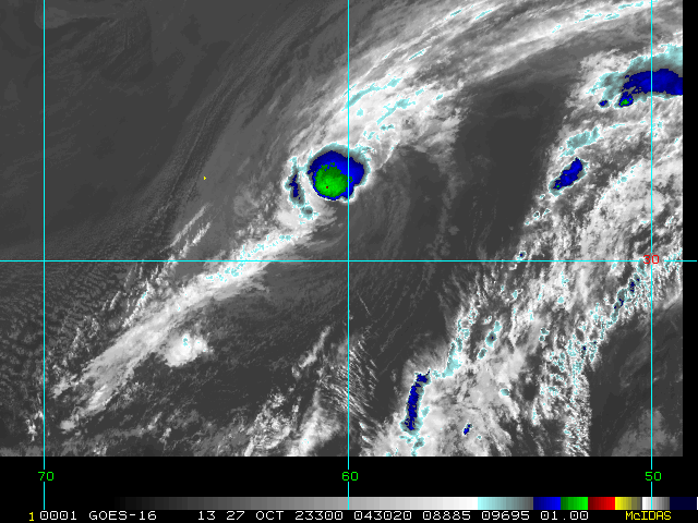
GOES Floater
Animated Model Plot of Tammy
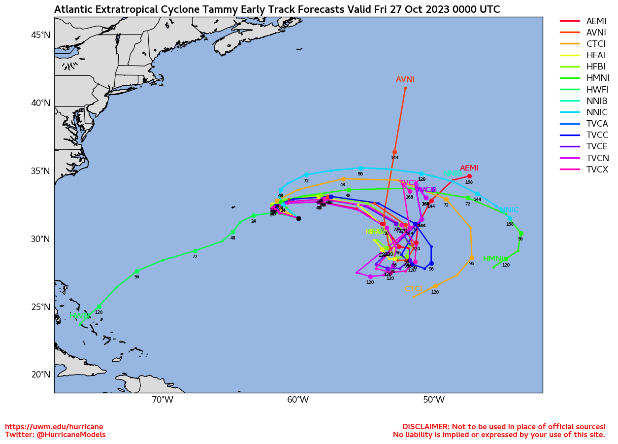
Clark Evans Track Model Plot of Tammy
(Animated!) Model Plots in Google Earth - In Google Maps
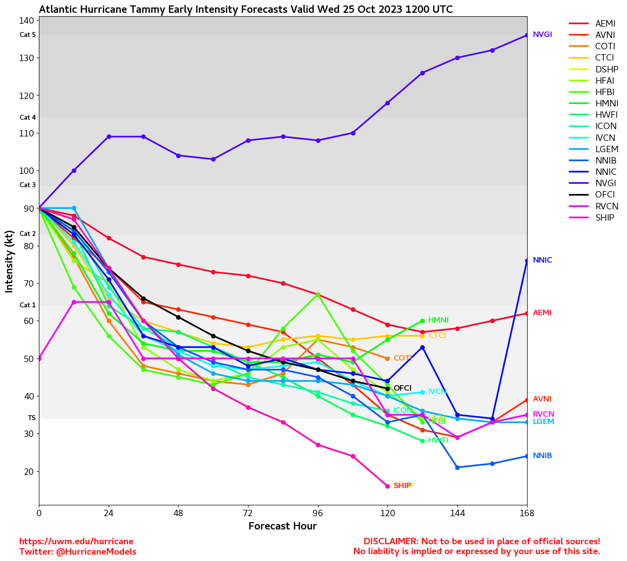
Clark Evans Intensity Model Plot of Tammy (Animated!)
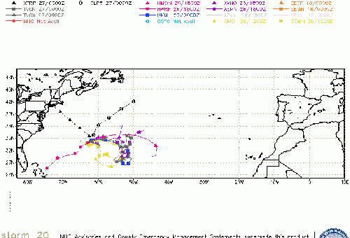
Clark Evans Track Plot of Tammy
Other Model Charts from Clark
Clark Evans Top 10 Analog Storms for Tammy
More model runs on from RAL/Jonathan Vigh's page
NRL Info on Tammy -- RAMMB Info
COD Atlantic Satellite View
StormCarib Reports from the Caribbean Islands
Caribbean Weather Observations
Barbados Brohav Weather Fax
Full Caribbean Radar Composite
Caribbean Broadcast Corporation (TV/Radio from Antilles)
San Juan, PR NWS Page
Various Caribbean Radio Stations
DR1 Dominican Republic Hurricanes
|
|
 Threaded


