Clark
Meteorologist
Reged: Wed
Posts: 1710
Loc:
|
|
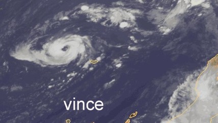
The 2005 Atlantic Hurricane Season continues to surprise and amaze. In conjunction with a persistent upper-level low in the eastern Atlantic, a surface low developed yesterday and quickly became organized this morning and early afternoon, resulting in the development of the season's 27th named storm of the season, Zeta. Only one other storm that I can recall -- "Alice2" of 1954 -- formed this late in the year, lasting into January 1955; of course, there are likely others in or out of the database as well. Zeta is also the season's 6th Greek named storm and, in a punny twist of fate, is often used by meteorologists as the symbol to represent vorticity -- or, as Jim Cantore puts it, spin -- a feature which tropical cyclones certainly have a lot of.
Zeta formed in a somewhat peculiar manner, with elements of Vince, Delta, and Epsilon (location), elements of some of this season's western Atlantic storms (enhancement by an upper-level low), and perhaps even elements of pure tropical development (convection fires within a mid-level feature, spins up a low-level circulation, convection dies out, the circulation organizes, and we get a tropical disturbance out of it). We'll watch it as we head into the new year -- needless to say, Zeta will almost assuredly be the last named storm of the 2005 season. It may just make it to 2006 as it slowly moves toward the west-northwest over the next couple of days.
More coming soon.
Event-specific links
(click image for full-size -- now all current!)

Skeetobite Track Map of Zeta
SSD GOES Floater on Zeta
S. Fla. WMD Model Plot
Thanks to Random Chaos for the following links:
NASA GHCC - 6 Frame IR Animation
NASA GHCC - 12 Frame IR Animation
PSU IR Loop
|
Random Chaos
Weather Analyst

Reged: Sat
Posts: 1024
Loc: Maryland
|
|
More visual links (duped from my other post):
IR Images of Zeta:
NASA GHCC - 6 Frame IR Animation
NASA GHCC - 12 Frame IR Animation
PSU
|
CaneTrackerInSoFl
Storm Tracker

Reged: Mon
Posts: 395
Loc: Israel
|
|
Haha. This is ridiculous. Just to ring in the new year, a new tropical storm. 2005 is really running right up to the wire.
--------------------
Andrew 1992, Irene 1999, Katrina 2005, Wilma 2005
|
emackl
Storm Tracker
Reged: Sat
Posts: 205
Loc: Indianapolis
|
|
Sorry if this is a stupid question but if Zeta makes it to Jan 1 will it be listed in the 2006 storm history as well?
What a crazy year.
Jackie
|
ChessieStorm
Weather Watcher
Reged: Thu
Posts: 49
Loc: Spring Hill, Fla. (Hernando C...
|
|
If Zeta makes it to January 1st, it will still go under the 2005 storm season since it was named in 2005.
Obviously any storm forming after January 1st will go under the 2006 season setup
|
Jenny
Verified CFHC User
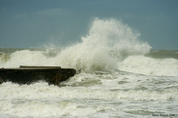
Reged: Fri
Posts: 16
Loc: Bradenton, Florida
|
|
Just when I thought is was safe to put away all the hurricane supplies. 
--------------------
Jenny
www.bbdigitalphoto.com
|
Margie
Senior Storm Chaser

Reged: Fri
Posts: 1191
Loc: Twin Cities
|
|
Thank you Franklin for another memorable quote:
ALTHOUGH THE ATMOSPHERE SEEMS TO WANT TO DEVELOP TROPICAL STORMS AD NAUSEAM...THE CALENDAR WILL SHORTLY PUT AN END TO THE USE OF THE GREEK ALPHABET TO NAME THEM.
He also noted the bands looking more ragged (you were right RC) and the westerlies already starting to show an effect (this can be seen on IR sat images today as well...as the storm has been moving west today, the circulation to the west dissipates past about 38W).
--------------------
Katrina's Surge: http://www.wunderground.com/hurricane/Katrinas_surge_contents.asp
|
eduardo sanchez
Registered User
Reged: Wed
Posts: 9
Loc: spain
|
|
Uno mas, para despedir 2005 llega zeta increible pero cierto, uno mas en la larga lista, no termina ya la sesion?? feliz a�o nuevo zeta.
One but, to dismiss 2005 arrives zeta incredible but certain, one but in the long list, does not finish the session already? zeta Happy New Year.
Rough translation by Babelfish~danielw
Edited by danielw (Sat Dec 31 2005 01:06 AM)
|
Random Chaos
Weather Analyst
Reged: Sat
Posts: 1024
Loc: Maryland
|
|
I'm looking at IR and it looks like Zeta's flaring convection again. SSMIS just barely missed the core of the storm, so I don't have any microwave imagery, but I'd say it's strengthening again. My guess: it'll definately still be a TS tomorrow morning, and quite possibly also for tomorrow evening.
The GHCC NHE sat seems to be having problems, so I can't compare the images to what I was looking at earlier. Oh, note that if you click the 12 frame version I linked above, you can just change the number of frames anywhere from 2 to 30 at the end of the URL.
|
Margie
Senior Storm Chaser
Reged: Fri
Posts: 1191
Loc: Twin Cities
|
|
I thought the convection flareup might be due to shear. I have to admit the most recent frames the blowup of convection is right over the center.
I don't think it'll get the chance to wrap around...convection, and all the outflow, is very asymmetrical -- mainly NNE of the center, and the LLC is exposed to the south. If Zeta wasn't moving west, may have had a better chance...convection is still not making it past about 38W, and the center is by now fairly close to 37.5W. And possibly some dry air continues to wrap around the south and up into the east part of the core.
---
Latest SSC classification has switched to subtropical...explanation, please. Is this referring to the large majority of convection now being far removed from the center (and possibly the windfield being more spread out?)...or does it mean the recent increase in convection is more baroclinic in nature?
DATE/TIME LAT LON CLASSIFICATION STORM
30/2330 UTC 25.7N 37.3W ST2.5/3.0 97
30/1145 UTC 24.7N 36.4W T2.5/2.5 97
30/0545 UTC 24.3N 36.4W T1.0/1.5 97
--------------------
Katrina's Surge: http://www.wunderground.com/hurricane/Katrinas_surge_contents.asp
|
Clark
Meteorologist
Reged: Wed
Posts: 1710
Loc:
|
|
The classifications are all subjective (except for the Univ. of Wisconsin estimates, which are based off of an objective algorithm that is being tested), so changes can somewhat be based upon the judgement of the individual forecast. It's all supposed to be based off of satellite appearance, so I don't think the other factors come directly into consideration -- maybe indirectly. I don't really have a good answer one way or the other, though, beyond forecaster perrogative. If someone has a tad more information, though, I'd love to hear it.
--------------------
Current Tropical Model Output Plots
(or view them on the main page for any active Atlantic storms!)
|
Margie
Senior Storm Chaser
Reged: Fri
Posts: 1191
Loc: Twin Cities
|
|
I found out it was the windfield...in discussion #3. They can see the quickscat, but we can't.
THE QUIKSCAT DATA INDICATED TROPICAL STORM-FORCE WINDS FARTHER FROM THE CENTER IN THE EASTERN SEMICIRCLE THAN PREVIOUSLY THOUGHT.
Also that discussion started off kind of funny:
ZETA IS ROUGHLY HALF OF A TROPICAL STORM... WITH MOST OF THE CONVECTION EAST OF THE CENTER... BUT STILL SOME OF IT NEAR THE FAIRLY TIGHT CIRCULATION CENTER.
It looks like the exposed LLC is just starting to move more west...but the convection is not following. There is still convection over the center but I wonder how long that will remain.
|
Clark
Meteorologist
Reged: Wed
Posts: 1710
Loc:
|
|
Well, the can see them...I'm not sure they are supposed to go into the (separate) classifications, however. While the forecasters most likely know how to use the technique, it's a separate center (or centers) that performs the classifications. I'm sure they look at the QuikSCAT, but it's not a factor in the classification...unless they have decided to take the tropical vs. subtropical factor out of the satellite image classification whatsoever.
--------------------
Current Tropical Model Output Plots
(or view them on the main page for any active Atlantic storms!)
|
Margie
Senior Storm Chaser
Reged: Fri
Posts: 1191
Loc: Twin Cities
|
|
Oh sorry, you're right, I just mixed apples and oranges. Well it still follows though that the windfield is more indicative of a subtropical storm, anyway, if the strongest winds are mostly further from the center.
--------------------
Katrina's Surge: http://www.wunderground.com/hurricane/Katrinas_surge_contents.asp
|
Multi-Decadal Signal
Weather Guru
Reged: Thu
Posts: 149
Loc: BROWARD
|
|
What the non weather-bug world sees .
http://www.nytimes.com/2005/12/31/national/31zeta.html
Happy New Year to All...
--------------------
Who you gonna' believe?
Me, or your damn lying eyes?
_Ö_ _ö_
|
eduardo sanchez
Registered User
Reged: Wed
Posts: 9
Loc: spain
|
|
Last images of satellite shows Zeta better organiced , forecast indicates that after of 12 hours began to be weaken, but the season has to us already customary to surprises, Epsilon resisted to be debilitated until becoming hurricane, we will see that it happens with Zeta.
|
Frog
Registered User
Reged: Tue
Posts: 9
Loc: France
|
|
Quote:
Uno mas, para despedir 2005 llega zeta increible pero cierto, uno mas en la larga lista, no termina ya la sesion?? feliz a�o nuevo zeta.
One but, to dismiss 2005 arrives zeta incredible but certain, one but in the long list, does not finish the session already? zeta Happy New Year.
Rough translation by Babelfish~danielw
Margie, I think the translation would rather be :
Yet another one, Zeta arrives to say a farewell to 2005, unbelievable but true, another one in this long list, wasn't the season supposed to be over ?! Happy New Year Zeta.
And Happy New Year to you all folks !
--------------------
Nature Rules !!!
"... and crawling on the Planet's face... some insects, called the Human Race... Lost in Time, Lost in Space... and Meaning"
(The Rocky Horror Picture Show, Final Scene)
|
eduardo sanchez
Registered User
Reged: Wed
Posts: 9
Loc: spain
|
|
Thanks to all for your help.
Edited by eduardo sanchez (Sat Dec 31 2005 10:34 AM)
|
Random Chaos
Weather Analyst
Reged: Sat
Posts: 1024
Loc: Maryland
|
|
Well, microwave imagery doesn't show to great a storm. put out their 10am advisoriy - winds up to 50kts but they agree the storm doesn't look great.
Based on the forcast from the , we're going to have the first system of 2006 also...as Zeta spans into the new year.
--RC
|
HanKFranK
User

Reged: Mon
Posts: 1841
Loc: Graniteville, SC
|
|
no real reason the shear should abate. fitting way to end such a year as 2005, with a storm... even a shear-eaten one.
i guess clark is going to have to update his blog one more time for the last-minute addition. i mentioned it on the last thread after it was switched, so worth saying again: franklin has to be pinching himself over the precocious hurricane epsilon review, which began by stating that epsilon was the last storm of 2005. what a year it was; saying a storm that ate it on december 8th was the last wasn't even safe.
HF 1727z31december
|
 Threaded


