Weather456
Verified CFHC User
Reged: Sun
Posts: 14
|
|
Tropics Today
A tropical wave located 23W/24W, south of 16N, and moving west at 10-15knots has strong clusters of showers, just off the coast of Africa. Future of this storms is uncertain due large area of dust infront of it and wind shear.
A tropical wave over the open Atlantic is near 55 west, south of 22 north. This wave is moving westward at about 20 mph and will begin to impact the Lesser Antilles with some squally weather as early as Monday morning. While development is not immediately anticipated, this wave will need to be watched.
There is another tropical wave in the Caribbean along 74 west, south of 18 north. It continues to cause thunderstorms over Hispaniola and Jamaica. It is moving to the west at about 10-15 mph. No immediate development is expected, but thunderstorms may increase over the western Caribbean Sunday night and Monday.
Last, but not least, an area of low pressure off the Carolina Coast will move very slowly over the next day or so. This system will be over the warm waters of the Gulf Stream and may begin to show tropical characteristics as it moves slowly northward over the next couple of days.
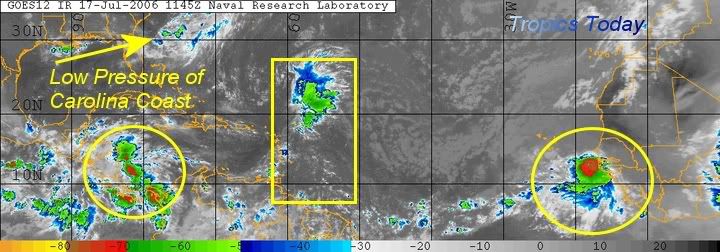
Figure 1: Tropical Atlantic
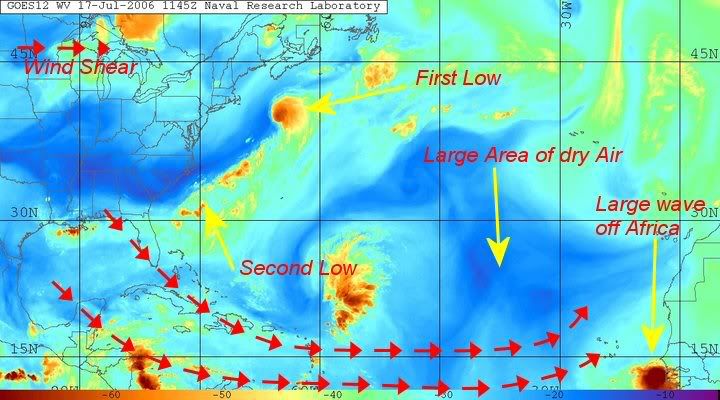
Figure 2: Water Vapor Imagery of Atlantic
--------------------
Weather456
|
HanKFranK
User

Reged: Mon
Posts: 1841
Loc: Graniteville, SC
|
|
Wow, not bad. How in the world did you get those shots to upload? I'm not having any luck and I'm a danged moderator. This covers some of the same stuff I just put in a new thread on the main page, and I'm going to reference this post since it shows things much more colorfully, and has a very balanced take on what's going on.
HF 1434z17july
|
|
 Threaded


