craigm
Storm Tracker

Reged: Wed
Posts: 327
Loc: Palm City, Florida
|
|
Sure enough, Noel seems to have more of a westward component and we know its not strong enough to be stair stepping. Approaching 79W now. I was sure it was starting the hard right turn but now how far west will he get, He has already overshot the forecast track. If indeed, like Storm Hunter points out, that is the LLC.
http://www.ssd.noaa.gov/goes/flt/t1/loop-rgb.html
--------------------
Why I'm here:
Weather hobbyist
Edited by craigm (Wed Oct 31 2007 11:48 AM)
|
Lamar-Plant City
Storm Tracker

Reged: Mon
Posts: 383
Loc: Plant City, Florida
|
|
That is absolutely wild...went to that satellite site and zoomed in on the area....an almost prefectly circular feature moving out from under the large convective burst!! Is this because the shear/trof is in the mid/upper levels and is not affecting the LLC as much? AND is this what they mean by Noel becoming 'extra-tropical' if it loses its LLC at the surface? What would it take for the LLC to develop convection and a life of its own? I am still planning a big camping trip for Fri-Sun on the north side of Tampa and this may change ALL of that.
--------------------
If you don't like the weather, wait 5 minutes...
2023 Season Prediction: 17/6/2
|
Colleen A.
Moderator

Reged: Sat
Posts: 1432
Loc: Florida
|
|
I am seeing the same thing...but I'm not sure if it's been jumping because I haven't really been following the loops, just TV! However, I trust your judgement!
All I know from the past is this: NEVER say NEVER when it comes to a storm. Of course, the mets on TV say "not to worry about it" while in the same breath say "keep a close eye on it". I think that is always interesting, no? Ugh 
--------------------
You know you're a hurricane freak when you wake up in the morning and hit "REFRESH" on CFHC instead of the Snooze Button.
|
LoisCane
Veteran Storm Chaser

Reged: Fri
Posts: 1236
Loc: South Florida
|
|
Thanks for the great graphics and yes...something is going on, very much so and i see more of a westward component than the 11am talked about ... and considering the 5am talked on 4 scenarios it would seem to be that before Noel goes out to sea...he can do a whole lot more damage than one would have thought yesterday at this time.
Something is happening and I'd like some explanations.
A much better sat presentation of the storm as a whole despite the inner workings or whereabouts of the LLC.
I don't really care if its extra-tropical, sub-tropical or tropical.. i care if it is going to get stronger and where it's going.
one complain i have had consistently with the is not track forecast but timing... they are always off on timing
and timing is more important for how it relates to intensity forecasting.. which proenza wanted to improve and needs improving
everyone in miami wanted to know if we would get hit by Noel on Wednesday and I kept telling them Thursday was the day to worry on not WEdnesday
What a difference a day makes....
--------------------
http://hurricaneharbor.blogspot.com/
|
Lee-Delray
Weather Master

Reged: Thu
Posts: 429
|
|
Lois
I think the reason they are calling it a High Wind Warning and not a Tropical Storm Watch is actually a legal issue. For a High Wind Warning no one has to close their busness', but a TS warning I think you have to. The municipalities would also have to use their EOC's as well. It's very expensive and inconvenient for 40 mph winds and an inch or so of rain. Also, a TS warning tends to create a panic.
Everyone keeps speaking of Charlie. Punto Gorda was in the 3 day cone and under a Hurricane Warning. Punta Gorda was also on the east side of a hurricane, wher SF is on the west side of a TS.
I think the is doing the right thing, for now. They are saying a TS Warning may come.
|
cieldumort
Moderator

Reged: Mon
Posts: 2305
Loc: Austin, Tx
|
|
I suspect that LLC is a little too large and spinning around a little too rapidly and coming from just the too perfect starting point to not be "the real deal." Now doesn't this development toss a whole new wrench in the mix. The 11AM forecast is possibly bust, not within one hour after issuance. Should this be the case, now one of two things have to happen to make the 11 happen: A) A -brand new- LLC needs to form within a new powerful convective burst (which doesn't appear to be happening anytime soon, as pressures are now rising per latest recon data and all-too-obvious cloud top warming is underway) or B) The "real deal" LLC and the MLC and its associated now waning deep convection have to meet back up and go through the whole re-coupling process all over again. Either way, it is not nearly as probable that both the 11AM's intensity and track verify as a result.
|
scottsvb
Weather Master
Reged: Mon
Posts: 1184
Loc: fl
|
|
Hold on everyone..lets not get to into the west jog..afterall most of the globals had this going to 79-80W before a turn late this evening into tonight...only the and HRW had this going straight NNW to NE. The Midlevel moisture is feeling the affect of the westerlys and weakening the system slightly over the last few hours pulling Noels LLC WNW but I feel its just a jog as it will turn back NNW then N later this evening. As said yesterday furthest I see this gets is near 80W but felt 78.5-79W was a best best. Now with the LLC jogging WNW the past few hours..it may make it alittle closer but still the turn was forecasted by the globals to begin this evening while the and few others said last night. Really its still on the forecast.
|
Stormin_thru
Registered User
Reged: Wed
Posts: 2
Loc:
|
|
Hello all,
I've been on this site watching and learing from everyone for some time now. I just wanted to take a minute to point out some of you may be overlooking from the 11am discussion.
"ALTHOUGH THE GLOBAL MODELS ARE NOT IN
GOOD AGREEMENT ON THE EVOLUTION OF THE CURRENT SURFACE CIRCULATION
OF NOEL...THEY ALL TAKE EITHER NOEL OR A NEW
DEVELOPMENT RAPIDLY NORTHEASTWARD"
|
Hurricane29
Weather Guru

Reged: Mon
Posts: 148
Loc: Miami Florida
|
|
|
doug
Weather Analyst
Reged: Mon
Posts: 1006
Loc: parrish,fl
|
|
WOW!...For a minimal TS the circulation coverages of this system are enormous!...Look at the current visible from the NOAA site on the West ATL view. The low level circulation around what is clearly the focus of Noel is huge...I don't think I've ever seen any thing like this.
--------------------
doug
|
Storm Hunter
Veteran Storm Chaser

Reged: Wed
Posts: 1370
Loc: Panama City Beach, Fl.
|
|
that looks to be the center.... here's recon flight path as of 11:45am
and Doug
Quote:
WOW!...For a minimal TS the circulation coverages of this system are enormous!...Look at the current visible from the NOAA site on the West ATL view. The low level circulation around what is clearly the focus of Noel is huge...I don't think I've ever seen any thing like this.
I think its more typical October.... late season storm.... we got a lot of factors in place... High Pressure, Low Pressure, Trough coming... that the large area doesn't really susprise me.... but this make for a tricky forecast... which most of the models are doing okay right now.... its not an exact science, but the forecast is looking good... been a few minor adjustments made, but for some of us, its been expected.... Shear is the next big factor for Noel i think.... before it gets beat up with the coming front.
Edited by Storm Hunter (Wed Oct 31 2007 12:57 PM)
|
MikeC
Admin
Reged: Sun
Posts: 4543
Loc: Orlando, FL
|
|
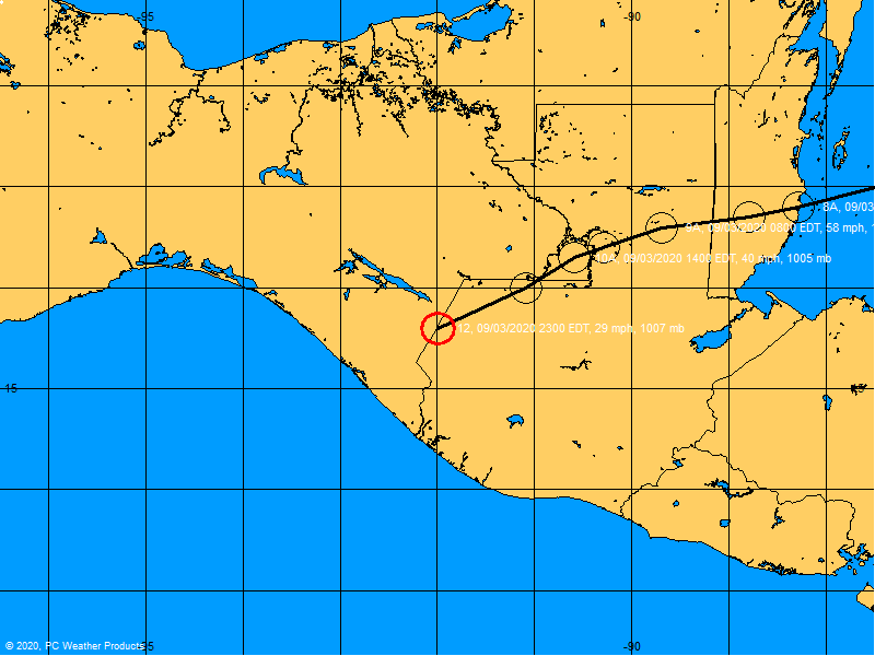
Yeah, my best guess for the center position based on visible and radar, now is about 79.0W, but it appears to be moving a bit more northward now too. Will wait for 2PM or so to see if it's a real trend or not.
It adds a bit to the mix, but I don't think it's going to cause a huge change.
edit: Latest recon shows 22.6N 78.8W, a bit WSW of the 11AM Position.
|
Hurricane29
Weather Guru
Reged: Mon
Posts: 148
Loc: Miami Florida
|
|
Special Weather Statement
SPECIAL WEATHER STATEMENT
NATIONAL WEATHER SERVICE MIAMI FL
1242 PM EDT WED OCT 31 2007
FLZ068-071>074-168-172>174-312100-
COASTAL BROWARD COUNTY-COASTAL MIAMI-DADE COUNTY-
COASTAL PALM BEACH COUNTY-FAR SOUTH MIAMI-DADE COUNTY-
INLAND BROWARD COUNTY-INLAND MIAMI-DADE-METRO BROWARD COUNTY-
METRO PALM BEACH COUNTY-METROPOLITAN MIAMI DADE-
1242 PM EDT WED OCT 31 2007
...SOUTH FLORIDIANS SHOULD MONITOR THE LATEST ON NOEL...
TROPICAL STORM NOEL HAS EMERGED OFF THE NORTH CENTRAL COAST OF CUBA
TODAY...AND DATA FROM HURRICANE HUNTER AIRCRAFT LATE THIS MORNING
INDICATE THAT NOEL HAS STRENGTHENED. MAXIMUM SUSTAINED WINDS ARE NOW
NEAR 50 MPH WITH HIGHER GUSTS. NOEL WAS MOVING IN A GENERAL NORTH TO
NORTHWEST DIRECTION AT 8 MPH. THE AIRCRAFT DATA ALSO INDICATED
TROPICAL STORM FORCE INCREASING SLIGHTLY IN THE NORTHWEST QUADRANT.
NOEL IS FORECAST TO MOVE ON A GENERAL NORTHERLY TRACK TODAY AND
TONIGHT...WITH ADDITIONAL STRENGTHENING EXPECTED.
IF THE TREND OF INCREASING WINDS IN THE NORTHWEST QUADRANT OF THE
STORM CONTINUES THIS AFTERNOON...PORTIONS OF SOUTHEAST FLORIDA
WOULD POSSIBLY BE CLOSER TO THE WINDS ASSOCIATED WITH THE INNER
CIRCULATION OF NOEL TONIGHT AND EARLY THURSDAY. AS A RESULT...A
TROPICAL STORM WARNING MAY BE NEEDED FOR PARTS OF SOUTHEAST FLORIDA
LATER THIS AFTERNOON OR EVENING.
THE STRONG WINDS OF THE PAST DAYS ACROSS SOUTH FLORIDA HAVE BEEN
ASSOCIATED WITH THE PRESSURE DIFFERENCE...OR GRADIENT...BETWEEN A
STRONG HIGH PRESSURE OVER THE MID ATLANTIC STATES AND TROPICAL
STORM NOEL TO THE SOUTH. THE WINDS ARE EXPECTED TO DECREASE OVER
SOUTH FLORIDA THIS EVENING AS THE HIGH WEAKENS. NEVERTHELESS...THE
POTENTIAL EXISTS FOR ANOTHER INCREASE IN WINDS LATER TONIGHT OR
EARLY THURSDAY AS THE WINDS DIRECTLY ASSOCIATED WITH NOEL APPROACH
SOUTHEAST FLORIDA.
DUE TO THE COMPLICATED NATURE OF THE SITUATION...ALL PERSONS IN
SOUTHEAST FLORIDA ARE URGED TO STAY ABREAST OF THE LATEST
ADVISORIES AND STATEMENTS FROM THE National Hurricane Center AND THE
MIAMI WEATHER FORECAST OFFICE...AND HEED THE ADVICE OF LOCAL
OFFICIALS IF TROPICAL STORM WARNINGS ARE ISSUED LATER THIS
AFTERNOON OR EVENING.
STAY TUNED TO NOAA WEATHER RADIO AND OTHER LOCAL MEDIA FOR FURTHER
DETAILS OR UPDATES.
$$
MOLLEDA
|
Hurricane29
Weather Guru
Reged: Mon
Posts: 148
Loc: Miami Florida
|
|
Looks like 50-70kt windshear just north of Noel.
Maybe also be associated with its outflow.
Edited by Hurricane29 (Wed Oct 31 2007 01:05 PM)
|
scottsvb
Weather Master
Reged: Mon
Posts: 1184
Loc: fl
|
|
I think Noel is slowing some...drifting still WNW along the coast (just off shore near 78.9W). 1 thing to look at is the NAM...it wants to keep Noel more West and most of the energy get pulled NE by a developing NON-Tropical Low.. ...now this situation isnt out of the question cause the Globals want to take something NE and they assume its Noel due to its approx to that area.....we might just have a weak low going around cuba.. but then again...its the model (though it hasnt done that bad with this soo far). Ill still go with the .
|
doug
Weather Analyst
Reged: Mon
Posts: 1006
Loc: parrish,fl
|
|
I agree with what you are saying...and the displacement from the convection is logiically shear related...looks like several things happening simultaneously...probably one of the most complex systems I have enjoyed observing.
--------------------
doug
|
Hurricane29
Weather Guru
Reged: Mon
Posts: 148
Loc: Miami Florida
|
|
2pm.
NOEL DRIFTED WESTWARD DURING THE PAST FEW HOURS...BUT IS CURRENTLY
NEARLY STATIONARY. A TURN TO THE NORTH IS EXPECTED LATER TODAY.
Edited by Hurricane29 (Wed Oct 31 2007 02:04 PM)
|
scottsvb
Weather Master
Reged: Mon
Posts: 1184
Loc: fl
|
|
The has been right on most of the time on this. Alittle too far to the south yesterday..but still showed it getting to near 79W and then stoping or/and then turning NE. Still I see this happening. I wouldnt throw out the but I cant go with that model over the with tropical systems. LOL!
|
ftlaudbob
Storm Chaser

Reged: Tue
Posts: 828
Loc: Valladolid,Mx
|
|
I would like to get some feed back about the storm stalling.Could this mean it will have more time to strengthen,and maybe change course?Looks like the will put out warnings for South East Florida late today.This storm would drive anyone crazy!
--------------------
Survived: 10 hurricanes in Rhode Island,Florida and the Yucatan of Mexico .
|
danielw
Moderator

Reged: Wed
Posts: 3525
Loc: Hattiesburg,MS (31.3N 89.3W)
|
|
With Noel... I mean No-end, anything is possible.
Yes a slowing or stalling would probably mean an increase in the wind speeds and a drop in the pressure. After all, the Gulf Stream passes through the Florida Straits.
|
 Threaded

 [Re:
[Re: 


