MikeC
Admin
Reged: Sun
Posts: 4543
Loc: Orlando, FL
|
|
8PM Update
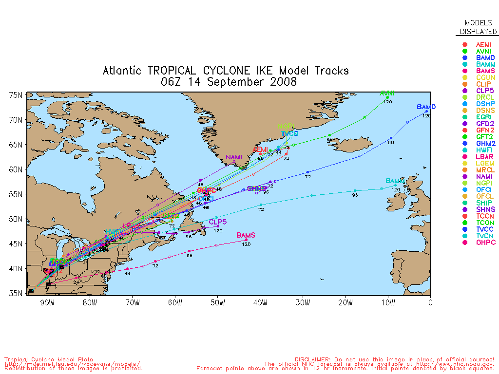
Ike looks to be taking the southerly route, back up to Category 4 strength, and still moving west southwest, it will likely make landfall in eastern Cuba and then eventually enter the Gulf, which means it is possible areas that Gustav hit will be affected once again. But the entire Gulf coast will want to watch it. Intensity wise, it is also uncertain how much it will be based on land interactions.

Original Update
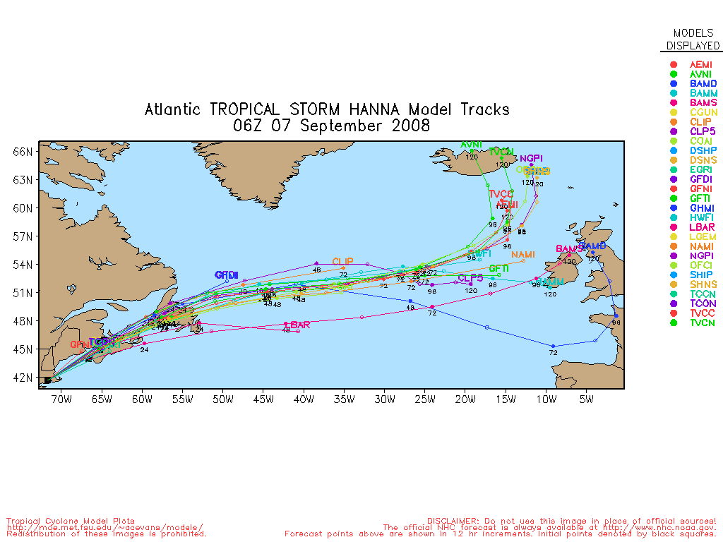
Tropical Storm Hanna is inland over North Carolina after making landfall at the NC/SC border, and it is racing North Northeast right now at 22MPH. It will affect Virginia and the coastal Northeast US before moving out to sea.
Hurricane Ike's forecast has moved south, perhaps skirting the northern coast of Cuba, or actually crossing Cuba before winding up in the Gulf. Which would unfortunately be another land falling hurricane on Cuba this year.
Since Ike is already a bit further south than projected, this looks the most likely situation. Which is better news for folks in Florida and the Keys, but the all clear is not ready yet.

None of the widely used tropical forecasting models have it crossing anywhere in Florida now, at least from the east or south side. It's too early to determine what will occur in the Gulf, although it is likely to wind up in the Central to Eastern Gulf next week, possibly close to Florida West coast, as the shows this morning, or further west in the Gulf.
Parts of Florida remain in the cone, so it is worth keeping an eye on, but the concern for the east coast of Florida is much much less than a day ago. And it will likely be close enough to the keys to cause watches or warnings and some Ike effects could be felt there.
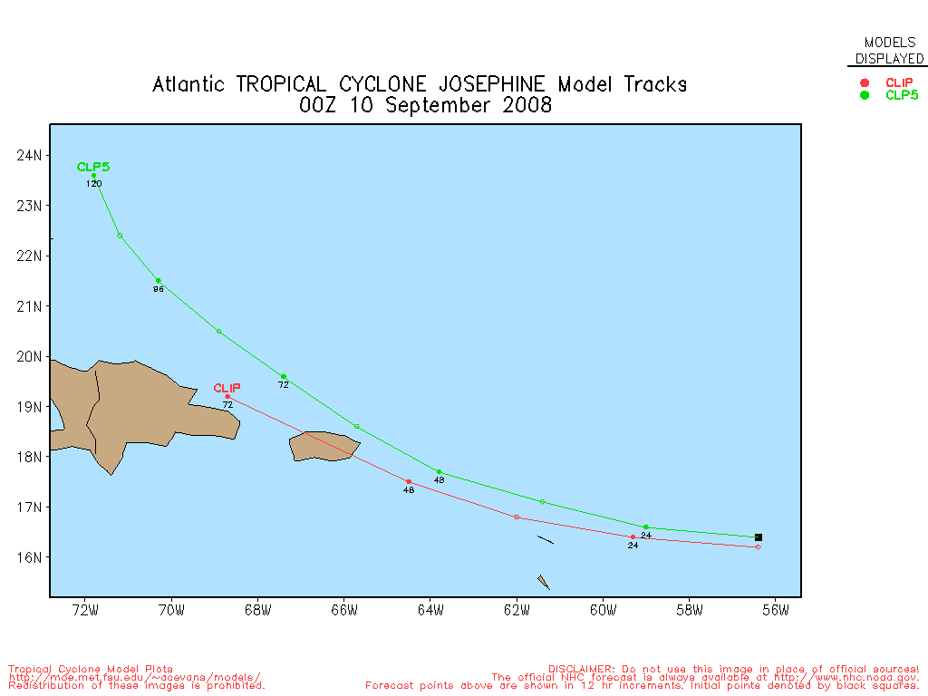
Josephine was torn apart by shear and now has dissipated, and is no longer being tracked.
Color Sat of Gulf
RAMSDIS high speed visible Floater of Storms
Spaghetti Style model plots from Colorado State University
Forecast Discussions for (Show All Locations)
Charleston, SC
Wilmington, NC
Morehead City, NC
Hampton Roads Area of Virginia
Washington, DC
Philadelphia, PA
Emergency Management:
North Carolina Emergency Management
South Carolina Emergency Management
Ike Related:
State of Florida Division of Emergency Management/floridadisaster.org
Florida County Emergency Management Websites
Forecast Discussions for (Show All Locations):
Tampa,Miami, Key West, Melbourne
Tallahassee
Southeast Radar Composite (loop)
Jacksonville Radar Radar Loop
(Latest Static)
Melbourne Radar Radar Loop
(Latest Static)
Charleston, SC Radar Radar Loop
(Latest Static)
Wilmington, NC Radar Radar Loop
(Latest Static)
Morehead City, NC Radar Radar Loop
(Latest Static)
Wakefield/ Norfolk/ VA Beach, VA Radar Radar Loop
(Latest Static)
Dover, DE Radar Radar Loop
(Latest Static)
Mount Holly, NJ Radar Radar Loop
(Latest Static)
Google Plot of Hanna, Ike, and Josephine
StormCarib Reports from the Caribbean Islands
Caribbean Weather Observations
Barbados Brohav Weather Fax
Full Caribbean Radar Composite
Caribbean Broadcast Corporation (TV/Radio from Antilles)
San Juan, PR NWS Page
Various Caribbean Radio Stations
DR1 Dominican Republic Hurricanes
Caribbean Islands Weather Reports
Hanna Event Related Links


SFWMD Model Plot (Animated Model Plot) SFWMD Hurricane Page
[https://flhurricane.com/floatanimator.php?year=2008&storm=8 Flhurricane Satellite Floater Animation of Hanna
GOES Floater
Animated Model Plot of Hanna
Clark Evans Track Model Plot of Hanna
(Animated!) Model Plots in Google Earth - In Google Maps
Clark Evans Intensity Model Plot of Hanna (Animated!)
Clark Evans Track Plot of Hanna
Other Model Charts from Clark
Clark Evans Top 10 Analog Storms for Hanna
More model runs on from RAL/Jonathan Vigh's page
NRL Info on Hanna -- RAMMB Info
COD Atlantic Satellite View
Ike Event Related Links


SFWMD Model Plot (Animated Model Plot) SFWMD Hurricane Page
[https://flhurricane.com/floatanimator.php?year=2008&storm=9 Flhurricane Satellite Floater Animation of Ike
GOES Floater
Animated Model Plot of Ike
Clark Evans Track Model Plot of Ike
(Animated!) Model Plots in Google Earth - In Google Maps
Clark Evans Intensity Model Plot of Ike (Animated!)
Clark Evans Track Plot of Ike
Other Model Charts from Clark
Clark Evans Top 10 Analog Storms for Ike
More model runs on from RAL/Jonathan Vigh's page
NRL Info on Ike -- RAMMB Info
COD Atlantic Satellite View
Josephine Event Related Links


SFWMD Model Plot (Animated Model Plot) SFWMD Hurricane Page
[https://flhurricane.com/floatanimator.php?year=2008&storm=10 Flhurricane Satellite Floater Animation of Josephine
GOES Floater
Animated Model Plot of Josephine
Clark Evans Track Model Plot of Josephine
(Animated!) Model Plots in Google Earth - In Google Maps
Clark Evans Intensity Model Plot of Josephine (Animated!)
Clark Evans Track Plot of Josephine
Other Model Charts from Clark
Clark Evans Top 10 Analog Storms for Josephine
More model runs on from RAL/Jonathan Vigh's page
NRL Info on Josephine -- RAMMB Info
COD Atlantic Satellite View
|
pcola
Storm Tracker

Reged: Wed
Posts: 344
Loc: pensacola/gulf breeze
|
|
latest has a major hurricane running up the west coast of FL...models continue to bounce east and west...there are too many variables right now 5 days out..a weak trough means Ike goes towards the central Gulf, a strong one puts the west coast of the peninsula in play...Ikes speed over the next 2 days is critical....everyone from the keys to TX need to pay attention.....
--------------------
Erin 95 , Opal 95, Ivan 04, Dennis 05, and that's enough!!!!
|
ftlaudbob
Storm Chaser

Reged: Tue
Posts: 828
Loc: Valladolid,Mx
|
|
It's very important that everyone in the CONE pay close attention.Ike is still way to the SE of Florida,many things can happen.There is a reason why they put out a cone,and this cone covers almost 700 miles by day 5.This is a good time to remember Charlie.The black line had Charlie going into Tampa,but it took a sharp right turn and slammed Punta Gorta.Punta Gorta WAS in the cone.
--------------------
Survived: 10 hurricanes in Rhode Island,Florida and the Yucatan of Mexico .
|
CDMOrlando
Weather Hobbyist

Reged: Wed
Posts: 57
Loc: seminole cnty florida
|
|
MODEL DIAGNOSTIC DISCUSSION
NWS HYDROMETEOROLOGICAL PREDICTION CENTER CAMP SPRINGS MD
100 AM EDT SAT SEP 06 2008
MODEL INITIALIZATION...
...SEE NOUS42 KWNO ADMNFD FOR STATUS OF UPPER AIR INGEST...
IKE...
A CROSS-SECTION OF THE LOOKING AT POTENTIAL VORTICITY SHOWS
A TYPICAL HURRICANE. HOWEVER...THE APPEARS TO HAVE THE SYSTEM TOO TILTED/SHALLOW AT INITIALIZATION...WHICH DOES NOT IMPROVE APPRECIABLY EVEN 108 HOURS INTO ITS FORECAST. THIS DEPTH PROBLEM COULD IMPACT ITS TRACK LATE IN THE SHORT RANGE...AND INTO THE MEDIUM RANGE PERIOD.
IKE...
THE HAS TRENDED SOUTHWEST WITH THIS SYSTEM OVER ITS PAST DAY OF RUNS. THE IS IN THE MIDDLE OF THE SPREAD SEEN DURING ITS PAST COUPLE DAYS OF RUNS. THE HAS TRENDED WEST-SOUTHWEST WITH THIS SYSTEM OVER ITS PAST 36 HOURS OF RUNS...BUT SOME OF THIS COULD BE RELATED TO THE PROBLEMS WITH ITS INITIAL DEPTH NOTED IN THE INITIALIZATION SECTION ABOVE.
MODEL DIFFERENCES AND PREFERENCES...
IKE...
THE CANADIAN IS THE MOST NORTHEAST WITH THIS SYSTEM...WHILE THE /ECMWF MOVE THE SYSTEM INTO CENTRAL CUBA LATE SUNDAY. MODEL TRENDS SUGGEST AN -LIKE SOLUTION WOULD BE PREFERRED DUE TO
ITS BETTER CONTINUITY AND THE /NAM TRENDS TOWARDS THIS
SOLUTION. HOWEVER...THE HAS PROBLEMS WITH ITS INITIALIZATION THAT COULD BE CONTAMINATING ITS FORECAST SOLUTION EARLY NEXT WEEK. A FASTER RENDITION OF THE 00Z CANADIAN...OR NORTHWARD VERSION OF THE FS/ECMWF...WOULD BE MOST SIMILAR TO THE ONGOING FORECAST
|
Raymond
Weather Guru
Reged: Wed
Posts: 112
Loc: Germany
|
|
Very interesting! The shear must have been relaxed quite a lot. The outflow has improved quite much and the convection is much stronger, especially in the northwestern half. The last microwave pass has revealed the surprise: Ike has formed a complete second outer wall and there is obviously the first eyewall replacement cycle starting! So at least no rapid intensification to expect in the face of the improved conditions!
And what becomes more and more obvious: Ike will make a first landfall in about 24 hours on Cuba. The question is: Will it stay close to oder over the northern coast or will it move for a long time more in the middle of Cuba. So weakening will be more or less significant, but modells also still show in any case a reintensification to a major hurricane in the Gulf. Conditions should be quite good for this.
|
GLT
Verified CFHC User
Reged: Wed
Posts: 12
Loc: Central FL
|
|
Could you post a link to that run please?
I assume the "major hurricane" is Ike?
I'm looking at and I don't see that at all - point towards the panhandle for IKE - do you have a newer version?
Post #3
I'm in the cone - should I evacuate now?
Thanks,
GLT
|
danielw
Moderator

Reged: Wed
Posts: 3525
Loc: Hattiesburg,MS (31.3N 89.3W)
|
|
Based on the Model Discussion.
If the is run off of the . And the is having trouble initialising a CAT 3 Hurricane.
Then one could assume the might be a tad off in any direction.
Dirty data in equals dirty data out.
|
smorse22
Verified CFHC User
Reged: Mon
Posts: 17
Loc: North Port, Fl
|
|
Quote:
Could you post a link to that run please?
http://my.sfwmd.gov/portal/page?_pageid=3194,21328260,3194_21169354:3194_21260388:3194_21260861&_dad=portal&_schema=PORTAL
What's keeping Ike to the south? Is there a image that shows this?
|
GLT
Verified CFHC User
Reged: Wed
Posts: 12
Loc: Central FL
|
|
That appears to be a link to HANNA runiing up the EAST US coast.
|
smorse22
Verified CFHC User
Reged: Mon
Posts: 17
Loc: North Port, Fl
|
|
Click on storm 9 on top of the page
|
CDMOrlando
Weather Hobbyist
Reged: Wed
Posts: 57
Loc: seminole cnty florida
|
|
Quote:
Based on the Model Discussion.
If the is run off of the . And the is having trouble initialising a CAT 3 Hurricane.
Then one could assume the might be a tad off in any direction.
Dirty data in equals dirty data out.
A G-IV {up level air analysis) mission would be very helpful with all of the model runs. The greater the data and the better the data the better the models run.
|
GLT
Verified CFHC User
Reged: Wed
Posts: 12
Loc: Central FL
|
|
OK - I see - looking on storm 9 on the mud page and then the track (thanks - looks a little newer than ) - yep it's now a little close to Tampa later - way too scary!!
Thanks again,
GLT
EDIT: It should be noted that the is by FAR the closest to Tampa than ANY other model - probably for the good reasons posted above.
Edited by GLT (Sat Sep 06 2008 09:46 AM)
|
smorse22
Verified CFHC User
Reged: Mon
Posts: 17
Loc: North Port, Fl
|
|
The weather channels Dr. Steve Lyons was talking about this being a Fl event from the panhandle along the west coast of florida. They're are expecting it to turn to the right once in the gulf because of a trough. Better keep a eye on this one. I don't want to see another !
|
CDMOrlando
Weather Hobbyist
Reged: Wed
Posts: 57
Loc: seminole cnty florida
|
|
The steering current are already starting to change to a move zonal flow and relax in intensity see 9 Hours TC Previous Steering Layer : 300-850 hPa TC MSLP : 950-969 hPa 0200
CIMSS
Latest Available
Steering Layer : 300-850 hPa
TC MSLP : 950-969 hPa
CIMSS
This is time sensitive and will update in 3 hours
|
Hugh
Senior Storm Chaser
Reged: Fri
Posts: 1060
Loc: Okaloosa County, Florida
|
|
Lyons is saying it's a west coast of Florida event, when NONE of the models are pointing toward the west coast of Florida right now? Interesting. I'd say Texas is just as likely as the west coast of Florida right now, given the model trends toward the west.
--------------------
Hugh
Eloise (1975) - Elena and several other near misses (1985) - Erin & Opal (1995) - Ivan (2004)
|
shewtinstar
Verified CFHC User
Reged: Mon
Posts: 23
Loc: Jacksonville, Fl
|
|
I have a question and I am not sure where to post it. Why would the put an Atlantic floater on a system that is in the Pacific?? They have two floaters on Invest 99E. I have never seen them do that before.
|
kromdog
Weather Hobbyist
Reged: Mon
Posts: 66
Loc:
|
|
Quote:
Lyons is saying it's a west coast of Florida event, when NONE of the models are pointing toward the west coast of Florida right now? Interesting. I'd say Texas is just as likely as the west coast of Florida right now, given the model trends toward the west.
Here is a link to some more recent model runs. They appear to be shifting back towards the Florida peninsula.
http://www.hurricanecity.com/wx/index.ph...=tropsys640x480,tropimap_all&pn=1&ptm=&alt=tropinvestmap
|
Lee-Delray
Weather Master

Reged: Thu
Posts: 429
|
|
Read the 11:00 AM Discussion, they say it is too early to tell if the storm will turn north and parallel the western Florida coast. Dr Lyons as many keep saying Florida, but they should be saying The Keys, extreme southern Florida and possibly the west coast of Florida.
|
scottsvb
Weather Master
Reged: Mon
Posts: 1184
Loc: fl
|
|
Ok Dr Lyons could be right about a western florida event, but he just speculated and thats all anything is after 3 days out. First off the 6z run shifted east. We need consistant runs showing the same thing and with models converging on a specific area. Now with that said, models are good (especially the up to 72hrs), for up to 120hrs is a basic idea and can change( as told in the days 4,5 uncertainty cone). After 120hrs just dont even bother really unless you just want to see where it might go.(For Entertainment).
So by saying all this, just watch for consistancy and converging of the models up to 72hrs. Days 4,5 have a better chance of changing, and after that, dont take it for granted.!
|
madmumbler
Storm Tracker

Reged: Wed
Posts: 324
Loc: SWFL
|
|
Why do they even bother using the CLP5 model? That thing ALWAYS hooks hard to the right in the early runs. It's done it for pretty much every storm this season.
From the growing trend I'm seeing on most of the models as well as the 's official track, I'm still thinking that LA/AL/MI and even parts of TX should be keeping a really close eye on this thing. Every series of runs lately has been pulling it farther away from the west Fl coast (Keys are still well into the danger zone, however) and toward the Gulf Coast.
--------------------
Lesli in SWFL.
Friends help you move. Real friends help you move bodies.
|
 Threaded


