typhoon_tip
Meteorologist
Reged: Wed
Posts: 576
|
|
It is quite likely that Igor will be upgraded to a hurricane upon the 8pm advisory. Microwave imagery over the 1 to 1.5 hours give clear indication of a eye wall structure over the west south and east semicircles, with true centroid axis of rotation collocated. The wind was in the process of differentiating higher per the last frame over 60kts at this point.
|
WesnWylie
Weather Guru
Reged: Sat
Posts: 155
Loc:
|
|
Well, after 92L died down earlier this evening, it appears that some more convection is firing up close to the center. I think this will likely develop into a tropical depression sometime tomorrow.
--------------------
2011 Season Forecast: 16/09/04
2011 Systems: 10/01/01
|
Random Chaos
Weather Analyst

Reged: Sat
Posts: 1024
Loc: Maryland
|
|
As of 11:20pm, Igor is now a Category 1 hurricane.
Additionally, as of 11:20pm, the eastern Atlantic storm has been raised to 90% chance of development.
NHC: "SPECIAL OUTLOOK ISSUED TO RAISE DEVELOPMENT CHANCE FOR SYSTEM IN THE EASTERN ATLANTIC AND TO INDICATE IGOR AS A HURRICANE NOT A TROPICAL STORM..."
Full text:
http://www.nhc.noaa.gov/text/refresh/MIATWOAT+shtml/120319.shtml
|
danielw
Moderator

Reged: Wed
Posts: 3525
Loc: Hattiesburg,MS (31.3N 89.3W)
|
|
From right to left it's quite busy for Mid Season.
TD12 over the Cape Verde Islands.
Cat 2 Hurricane Igor with sustained winds of 105 mph.
Area in Central Caribbean Sea still being watched.
Area of disturbed weather over the Bay of Campeche'.
IR satellite photo taken at 1415Z or 1015 EDT.

Nearly perfect spacing of the three systems being watched in the Atlantic. Notice how the cloud streets feed from the top of one system into the bottom of the next system.

©2002-2010 Texas Commission on Environmental Quality
Edited by danielw (Sun Sep 12 2010 11:51 AM)
|
WeatherNut
Weather Master
Reged: Wed
Posts: 412
Loc: Atlanta, GA
|
|
special weather statement from ...Igor is now Cat4 w/ 135mph winds and has been rapidly intensifying
--------------------
Born into Cleo (64)...been stuck on em ever since
|
Random Chaos
Weather Analyst
Reged: Sat
Posts: 1024
Loc: Maryland
|
|
Igor is beautiful!
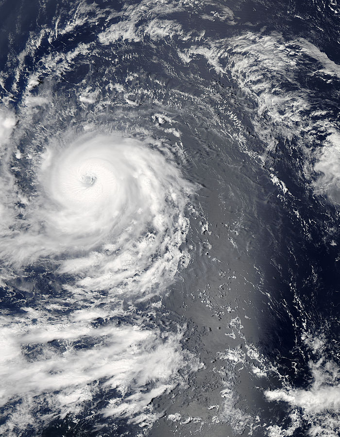
Source and higher resolution images
|
MikeC
Admin
Reged: Sun
Posts: 4543
Loc: Orlando, FL
|
|
Site Note: flhurricane will be down for 30 min to an hour for a hardware fix between 5:30-7PM, and should be back up hopefully fairly soon.
Edited by danielw (Sun Sep 12 2010 05:19 PM)
|
danielw
Moderator
Reged: Wed
Posts: 3525
Loc: Hattiesburg,MS (31.3N 89.3W)
|
|
Igor was predicted to have a 25kt increase in windspeeds by the 12Z SHIPS model in the 24 hours ending at 8 AM EDT Monday.
SHIPS also forecast Igor Not peaking until the 60-72 hour time frame from 8 AM EDT Sunday.
|
Storm Hunter
Veteran Storm Chaser

Reged: Wed
Posts: 1370
Loc: Panama City Beach, Fl.
|
|
Boom goes the Dynamite!  RI is central Atlantic.. amazing! Kinda looks like Hurricane Isabel 2003! RI is central Atlantic.. amazing! Kinda looks like Hurricane Isabel 2003!
http://i44.photobucket.com/albums/f13/stormhunter7/boom.gif
--------------------
www.Stormhunter7.com ***see my flight into Hurricane Ike ***
Wx Data: KFLPANAM23 / CW8771
2012== 23/10/9/5 sys/strms/hurr/majh
Edited by Storm Hunter (Sun Sep 12 2010 06:33 PM)
|
WeatherNut
Weather Master
Reged: Wed
Posts: 412
Loc: Atlanta, GA
|
|
Folks this looks like we might have an Annular Hurricane here as was Isabel (image attached) at some point as was
http://en.wikipedia.org/wiki/Annular_hurricane
if you have questions about what one is...but this is looking like a classic one...might even already be Cat5...wish we had a pressure reading...its 'L O W' I am sure.
"An annular hurricane is a tropical cyclone in the Atlantic or Eastern Pacific Oceans that features a large, symmetric eye surrounded by a thick ring of intense convection. This type of storm is not prone to the fluctuations in intensity associated with eyewall replacement cycles, unlike typical intense tropical cyclones. Annular hurricanes also tend to persist, even when encountering environmental conditions which easily dissipate most other hurricanes. Forecasters have difficulty predicting the behavior of annular hurricanes; they are a recently recognized phenomenon, and as such, little is known about their tendencies. Because of this, they can be more dangerous than typical hurricanes."
Edited by WeatherNut (Sun Sep 12 2010 06:57 PM)
|
typhoon_tip
Meteorologist
Reged: Wed
Posts: 576
|
|
Quote:
Folks this looks like we might have an Annular Hurricane here as was Isabel (image attached) at some point as was
http://en.wikipedia.org/wiki/Annular_hurricane
if you have questions about what one is...but this is looking like a classic one...might even already be Cat5...wish we had a pressure reading...its 'L O W' I am sure.
"An annular hurricane is a tropical cyclone in the Atlantic or Eastern Pacific Oceans that features a large, symmetric eye surrounded by a thick ring of intense convection. This type of storm is not prone to the fluctuations in intensity associated with eyewall replacement cycles, unlike typical intense tropical cyclones. Annular hurricanes also tend to persist, even when encountering environmental conditions which easily dissipate most other hurricanes. Forecasters have difficulty predicting the behavior of annular hurricanes; they are a recently recognized phenomenon, and as such, little is known about their tendencies. Because of this, they can be more dangerous than typical hurricanes."
Perhaps but not yet so. There are clearly feeder bands continuing to erupt with comparative cloud top temperatures as that associated with the inner core main ring. Additionally, microwave imagery clearly shows arms extending radially outward away from any annularity.
|
MikeC
Admin
Reged: Sun
Posts: 4543
Loc: Orlando, FL
|
|
It has a shot at become a category 5, but if it were to weaken it would probably be from the northeast side of the storm. It's not annular yet, but it has a shot to do so. 11PM may tell. Thankfully this one appears to be out to sea.
|
WeatherNut
Weather Master
Reged: Wed
Posts: 412
Loc: Atlanta, GA
|
|
Its a bit unnerving to see it still moving wsw though. There hasn't been much of a shift in the 8pm models though. My concern is a hurricane of this strength can 'pump up' the ridge making it stronger
--------------------
Born into Cleo (64)...been stuck on em ever since
|
Random Chaos
Weather Analyst
Reged: Sat
Posts: 1024
Loc: Maryland
|
|
Tropical Storm Julia as of 11pm update.
|
Storm Hunter
Veteran Storm Chaser
Reged: Wed
Posts: 1370
Loc: Panama City Beach, Fl.
|
|
Really wish NASA would have made a forward Operating base this year for the Global Hawk on the EAST coast... saves thousands of miles/fuel. Read next year will be based in Va., money permitting! GH is passing Cancun, back to Drydren
--------------------
www.Stormhunter7.com ***see my flight into Hurricane Ike ***
Wx Data: KFLPANAM23 / CW8771
2012== 23/10/9/5 sys/strms/hurr/majh
Edited by Storm Hunter (Mon Sep 13 2010 01:17 AM)
|
danielw
Moderator
Reged: Wed
Posts: 3525
Loc: Hattiesburg,MS (31.3N 89.3W)
|
|
I'm still seeing a 7 hour average of about 275 degrees, being generous, or due west From 03Z to 10Z. Using the link below, extreme slow speed and zoom on eye.
http://www.ssd.noaa.gov/goes/flt/t1/loop-vis.html
Long loop actually moved about 280 deg WNW for a while and then changed to 260 deg WSW giving a rough movement of due west.
|
WeatherNut
Weather Master
Reged: Wed
Posts: 412
Loc: Atlanta, GA
|
|
I'm not seeing the quick recurve the is showing. It looks like Igor has missed the first trough as it crosses 50w moving in a general W motion. These troughs exiting the US are not looking as robust as the ones that recurved Danielle, Earl and Fiona. They seem flat or zonal in comparison at the lower ends. If it does not recurve with the next trough, the JMA (Japanese) model will start to look more credible. It has been very consistent on the westerly direction through several runs
--------------------
Born into Cleo (64)...been stuck on em ever since
|
WPBSUE
Registered User

Reged: Thu
Posts: 3
|
|
The 11am discussion seemed to indicate there was less certainity with the projected path of Igor. Not sure that the Leewards or the southern US coast can breath a sign of relief just yet. I'll be watching closely as I hope others will be.
|
Storm Hunter
Veteran Storm Chaser
Reged: Wed
Posts: 1370
Loc: Panama City Beach, Fl.
|
|
Good morning Igor!  Sleep well i see... lol Sleep well i see... lol
Use link for large loop with track superimposed~danielw
http://i44.photobucket.com/albums/f13/stormhunter7/boom2.gif

Edited by danielw (Mon Sep 13 2010 02:25 PM)
|
JoshuaK
Weather Guru
Reged: Mon
Posts: 159
Loc: Lakeland, FL
|
|
Igor is maintaining a well defined eye but convection is weakening/decreasing associated with the system. Dry air that the system is moving into could be playing a part in that latter.
|
 Threaded

 [Re:
[Re: 

