MikeC
Admin
Reged: Sun
Posts: 4543
Loc: Orlando, FL
|
|
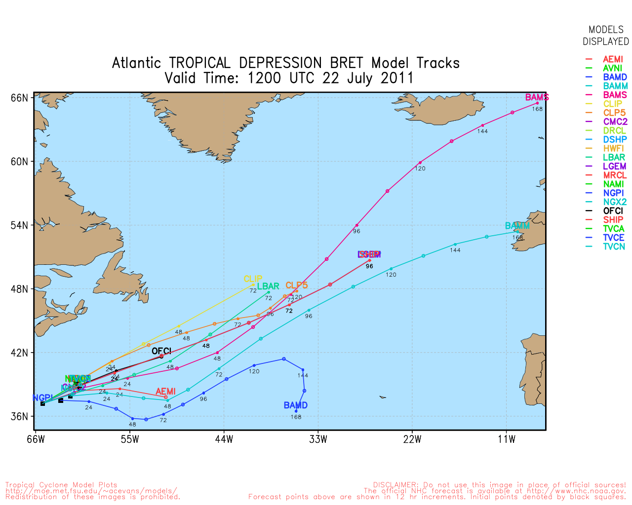
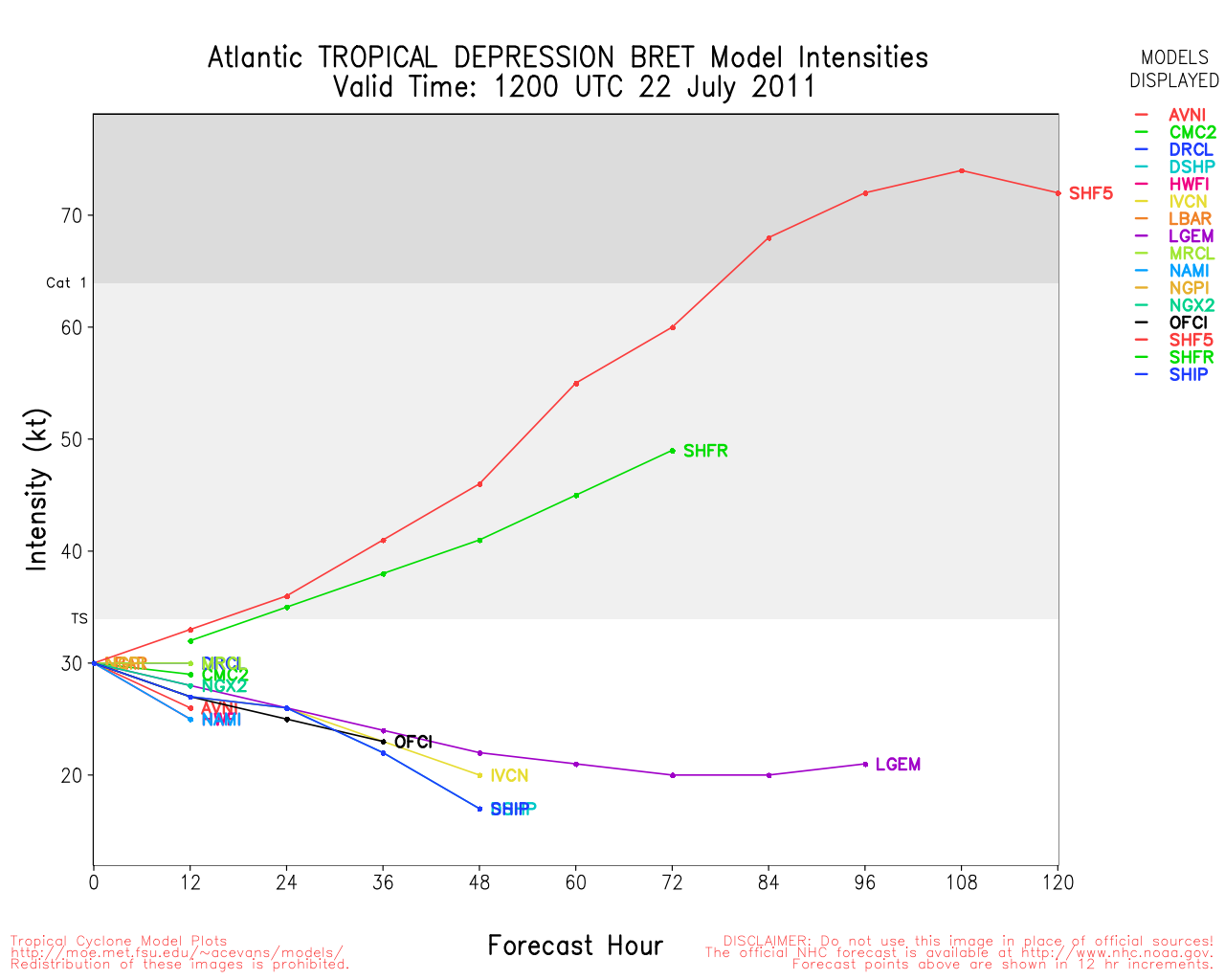
Update - Wednesday, July 13th, 10AM
An active wave in the Southwest Bay of Campeche has been designated as Invest 97L with about a 50/50 chance for additional intensification today prior to landfall. The system is close to shore - near Veracruz , Mexico, and it is moving to the west northwest at 16 knots.
ED
Weather Observations from Veracruz
98L Event Related Links


SFWMD Model Plot (Animated Model Plot) SFWMD Hurricane Page
[https://flhurricane.com/floatanimator.php?year=2011&storm=2 Flhurricane Satellite Floater Animation of 98L
GOES Floater
Animated Model Plot of 98L
Clark Evans Track Model Plot of 98L
(Animated!) Model Plots in Google Earth - In Google Maps
Clark Evans Intensity Model Plot of 98L (Animated!)
Clark Evans Track Plot of 98L
Other Model Charts from Clark
Clark Evans Top 10 Analog Storms for 98L
More model runs on from RAL/Jonathan Vigh's page
NRL Info on 98L -- RAMMB Info
COD Atlantic Satellite View
12 Jul Update
One of the signs forecasters look for is the situation with the Median-Julian-Oscillation (aka ) and signs are pointing to a possible early Cape Verde season the latter half of July into August. Which means in a few weeks we'll need to start looking east for signs of development.

Right now, there is a wave east of the Caribbean, which is worth watching to see if it survives the east Caribbean, and another in the western Caribbean that is approaching land and likely will make landfall well before it can develop. Both systems have a 10% chance for development in the next 48 hours.
A front over the Carolinas right now is worth watching to see if convection gets cut off and left in the Atlantic, if so it is possible for development to occur off the coast of the Carolinas late this week, but it really depends on how far the energy gets offshore.
None of these systems are likely to develop into much.
Original Update
Mid July is approaching in the Atlantic Hurricane Basin, and this period historically has been mixed, either very slow, or somewhat active.
This year, July appears to be on the slower side, at least so far.
There is one area east of the Caribbean which could develop later, right now it has a 10% chance, but very little model support for anything in the near term.
Those in the southern windward islands in the Eastern Caribbean will want to look for some rain from the area.
It may be worth watching later to see if it survives its time in the eastern Caribbean.
Outside of this, there really isn't much going on in the Atlantic.
Toward the end of July you start to look further and further east for development, and continue to look elsewhere in the basin. Most activity usually starts to occur until August (Mid to late August in particular).
That said, there really isn't much going on in the Atlantic tropics right now, and probably won't be for another week or so, but it's worth it to continue to monitor for "surprise" systems.
|
doug
Weather Analyst
Reged: Mon
Posts: 1006
Loc: parrish,fl
|
|
None of those appear ready to develop. The energy with the disturbance over the mid atlantic States is diving toward the southeast. The system entering the E. Carib. is losing its convection and is barely more than a cluster of rain showers. The energy moving into C. America is more likely to be conducive for cyclonegenesis, but in the E. Pac., IMHO.
--------------------
doug
|
danielw
Moderator

Reged: Wed
Posts: 3525
Loc: Hattiesburg,MS (31.3N 89.3W)
|
|
Checking the Forecasts at the website listed below. Computer models are forecasting the to remain in a positive phase for the next few days.
http://www.cpc.ncep.noaa.gov/products/precip/CWlink/MJO/CLIVAR/clivar_wh.shtml
|
Ed Dunham
Former Meteorologist & CFHC Forum Moderator (Ed Passed Away on May 14, 2017)
Reged: Sun
Posts: 2565
Loc: Melbourne, FL
|
|
Invest 97L is within 50 miles of the Mexican coast and should be inland in a few hours. The window for additional development is small but gusty winds and heavy showers are likely along the west coast of the Bay of Campeche today and tonight.
ED
|
danielw
Moderator
Reged: Wed
Posts: 3525
Loc: Hattiesburg,MS (31.3N 89.3W)
|
|
NHC has announced tentative flight plans for the system in the Lower Western Caribbean. This is dependent on the system maintaining it's current intensity, or intensifying.
WEATHER RECONNAISSANCE FLIGHTS
CARCAH, National Hurricane Center, MIAMI, FL.
1000 AM EDT THU 14 JULY 2011
SUBJECT: TROPICAL CYCLONE PLAN OF THE DAY (TCPOD)
VALID 15/1100Z TO 16/1100Z JULY 2011
TCPOD NUMBER.....11-044
I. ATLANTIC REQUIREMENTS
1. NEGATIVE RECONNAISSANCE REQUIREMENTS.
2. OUTLOOK FOR SUCCEEDING DAY: POSSIBLE LOW
LEVEL INVEST AT 16/1900Z NEAR 12N 82W.
(Saturday Morning flight-possible~danielw)
II. PACIFIC REQUIREMENTS
1. NEGATIVE RECONNAISSANCE REQUIREMENTS.
2. SUCCEEDING DAY OUTLOOK.....NEGATIVE.
|
Ed in Va
Weather Master
Reged: Fri
Posts: 489
Loc:
|
|
Anyone making anything of the front that has now moved east of the GA/SC coast? I guess this is the potential area that has been hinted at the past few days.
--------------------
Survived Carol and Edna '54 in Maine. Guess this kind of dates me!
|
FtMyersgal
Registered User
Reged: Thu
Posts: 1
Loc: Fort Myers FL
|
|
Quote:
Anyone making anything of the front that has now moved east of the GA/SC coast? I guess this is the potential area that has been hinted at the past few days.
Anyone have a comment on the wave at 45W?
|
MikeC
Admin
Reged: Sun
Posts: 4543
Loc: Orlando, FL
|
|
The frontal development off Georgia/Carolinas looks to have fallen apart, and likely will not develop. Some chances were still there yesterday, but those are all but gone today. Atlantic.
Still the end of July seems like it may get more activity.
Right now, beyond the Southwest Caribbean, there is a wave in the Central Atlantic, but it's marginal at the moment.
|
danielw
Moderator
Reged: Wed
Posts: 3525
Loc: Hattiesburg,MS (31.3N 89.3W)
|
|
The wave Mike mentioned in the far Atlantic, near 45W, still has some thunderstorm activity and the cirrus clouds over the area indicate little or no shear at present. It's low in latitude, and that could spell trouble for the South American Coast. Should the system gain latitude the Windward Islands and the rest of the Lesser Antilles could be affected.
A new stronger, at this time, wave has pushed off of the African Coast south of the Cape Verde Islands. Moderately large centralized area of thunderstorms, at present. Long ways off... 10 to 14 days.
Edited by danielw (Thu Jul 14 2011 06:23 PM)
|
 Threaded


