7AM EDT 25 July 2011
The wave known as 90L has moved over the northern Caribbean islands, currently just over or south of Cuba bringing some rain to the area.
Since it took the overland route, chances for development are very low to nonexistant, but if it manages to remain somewhat itnact by the time it reaches the gulf, then it has a chance to develop into a weak system then, but odds are against that happening.
Outside of this wave there is not much to talk about in the Tropics this week.
8AM EDT 23 July 2011
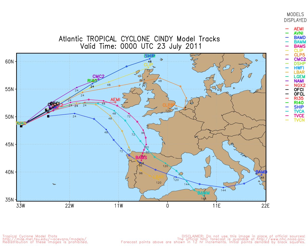
Cindy's last advisory was issued overnight, as the wave in the East Caribbean starts to move into the Caribbean sea.
This system's chances for development are dropping, at least in the near term as it enters the "hurricane graveyard" area of the east Caribbean. If it persists it could be something down the road, and those in the Caribbean will want to watch it, but it appears it will head further west and stay weak, at least for the next few days. Dry air destroyed 90L from the south.

90L actually is very unimpressive this morning, the area northeast of it looks better on Satellite, and that as a separate area may need attention later.
Still as August approaches, watch for the unexpected with systems dying off then reforming elsewhere, or later.
StormCarib Reports from the Caribbean Islands
Caribbean Weather Observations
Barbados Brohav Weather Fax
Full Caribbean Radar Composite
Caribbean Broadcast Corporation (TV/Radio from Antilles)
San Juan, PR NWS Page
Various Caribbean Radio Stations
DR1 Dominican Republic Hurricanes
90L Event Related Links


SFWMD Model Plot (Animated Model Plot) SFWMD Hurricane Page
[https://flhurricane.com/floatanimator.php?year=2011&storm=4 Flhurricane Satellite Floater Animation of 90L
GOES Floater
Animated Model Plot of 90L
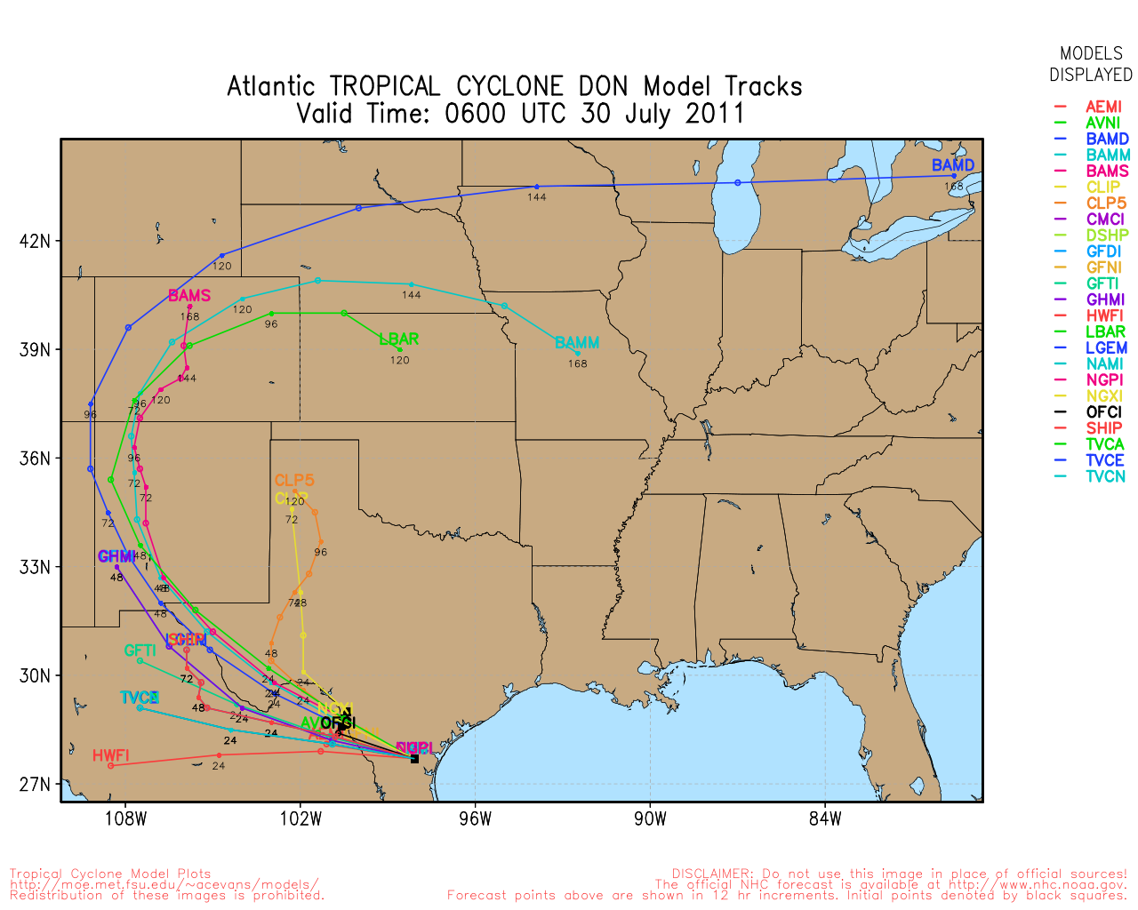
Clark Evans Track Model Plot of 90L
(Animated!) Model Plots in Google Earth - In Google Maps
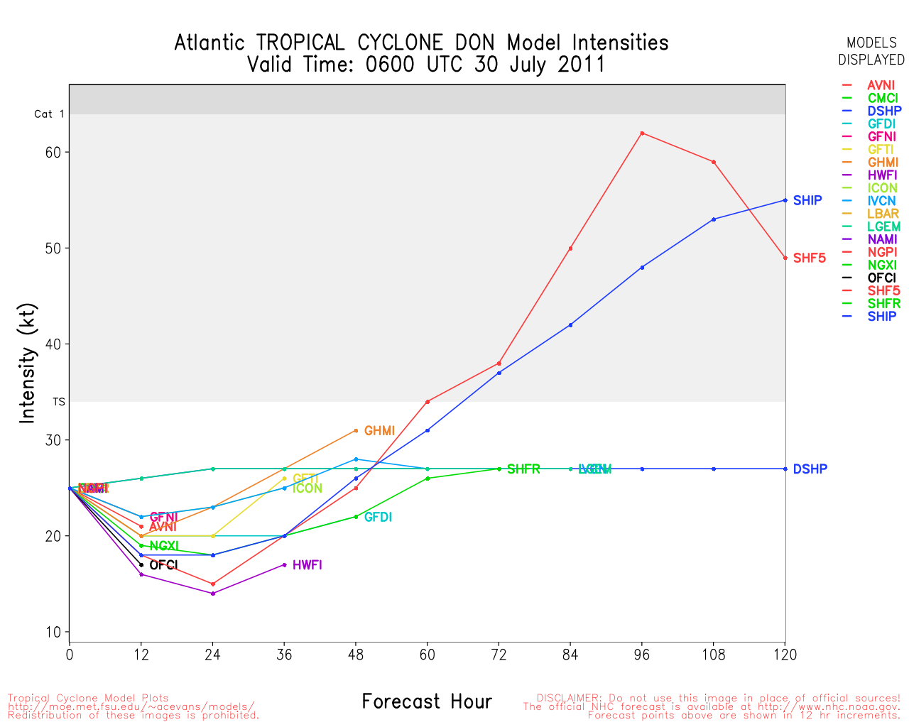
Clark Evans Intensity Model Plot of 90L (Animated!)
Clark Evans Track Plot of 90L
Other Model Charts from Clark
Clark Evans Top 10 Analog Storms for 90L
More model runs on from RAL/Jonathan Vigh's page
NRL Info on 90L -- RAMMB Info
COD Atlantic Satellite View
8PM EDT 22 July 2011
Cindy continues to slowly weaken as it races northeast into the Atlantic, the wave known as 90L east of the Caribbean is now up to a 30% chance for development in the next 48 hours. There's still quite a bit of question as to what this system will do, so you won't see much talk of it until trends solidify. However, it will likely move west of what the current forecast models show.
Those in the Caribbean islands will want to keep watch on this system, but there isn't an immediate threat. Early model runs are not good to use with systems like this wave, they tend to be biased toward the north too much.
It's worth keeping track of into next week, though. See the Forecast Lounge for more speculation on this system.
Original Update
The last advisory has been issued on Bret, Cindy has weakened, and the central Atlantic wave is now being tracked as 90L.
This wave will likely head west and move into the Caribbean, or pass over the Caribbean islands. Nothing right now suggests too much development in the short term, but those in the Leeward islands need to watch the system over the next few days. Development is more likely Sunday or Monday. In general, it is worth keeping an eye on,
There is a tentative recon flight scheduled to check out the 90L area tomorrow.
More to come later.
Martinique Radar Recording (flhurricane)
Ex-Cindy Event Related Links


SFWMD Model Plot (Animated Model Plot) SFWMD Hurricane Page
[https://flhurricane.com/floatanimator.php?year=2011&storm=3 Flhurricane Satellite Floater Animation of Ex-Cindy
GOES Floater
Animated Model Plot of Ex-Cindy
Clark Evans Track Model Plot of Ex-Cindy
(Animated!) Model Plots in Google Earth - In Google Maps
Clark Evans Intensity Model Plot of Ex-Cindy (Animated!)
Clark Evans Track Plot of Ex-Cindy
Other Model Charts from Clark
Clark Evans Top 10 Analog Storms for Ex-Cindy
More model runs on from RAL/Jonathan Vigh's page
NRL Info on Ex-Cindy -- RAMMB Info
COD Atlantic Satellite View
Ex-Bret Event Related Links


SFWMD Model Plot (Animated Model Plot) SFWMD Hurricane Page
[https://flhurricane.com/floatanimator.php?year=2011&storm=2 Flhurricane Satellite Floater Animation of Bret
GOES Floater
Animated Model Plot of Bret
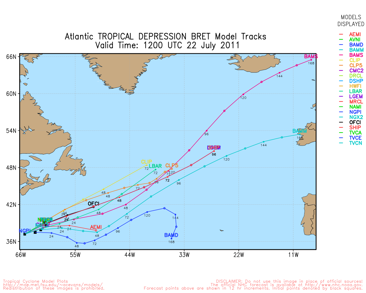
Clark Evans Track Model Plot of Bret
(Animated!) Model Plots in Google Earth - In Google Maps
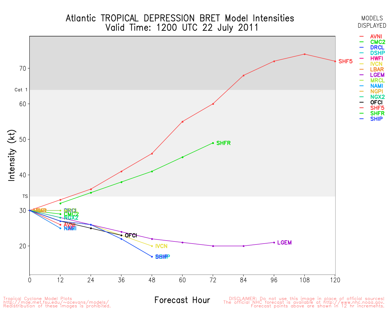
Clark Evans Intensity Model Plot of Bret (Animated!)
Clark Evans Track Plot of Bret
Other Model Charts from Clark
Clark Evans Top 10 Analog Storms for Bret
More model runs on from RAL/Jonathan Vigh's page
NRL Info on Bret -- RAMMB Info
COD Atlantic Satellite View
 Threaded


