8PM EDT 29 July 2011 Update
Chances for additional development of Invest 91L have increased to 50%. For additional info on this system see the Storm Forum .
ED
5PM EDT 29 July 2011 Update
Some of the rainfall associated with Tropical Storm Don is reaching Brownsville now, but actual center landfall north between Brownsville and Corpus Christi will occur late tonight.
The wave in the Central Atlantic hasn't changed much during the day, and still has a 30% chance for development over the next two days. The northern Leeward islands will want to continue to watch this system. What do you think the wave in the Atlantic will do? Let us know in the forecast lounge
Original Update
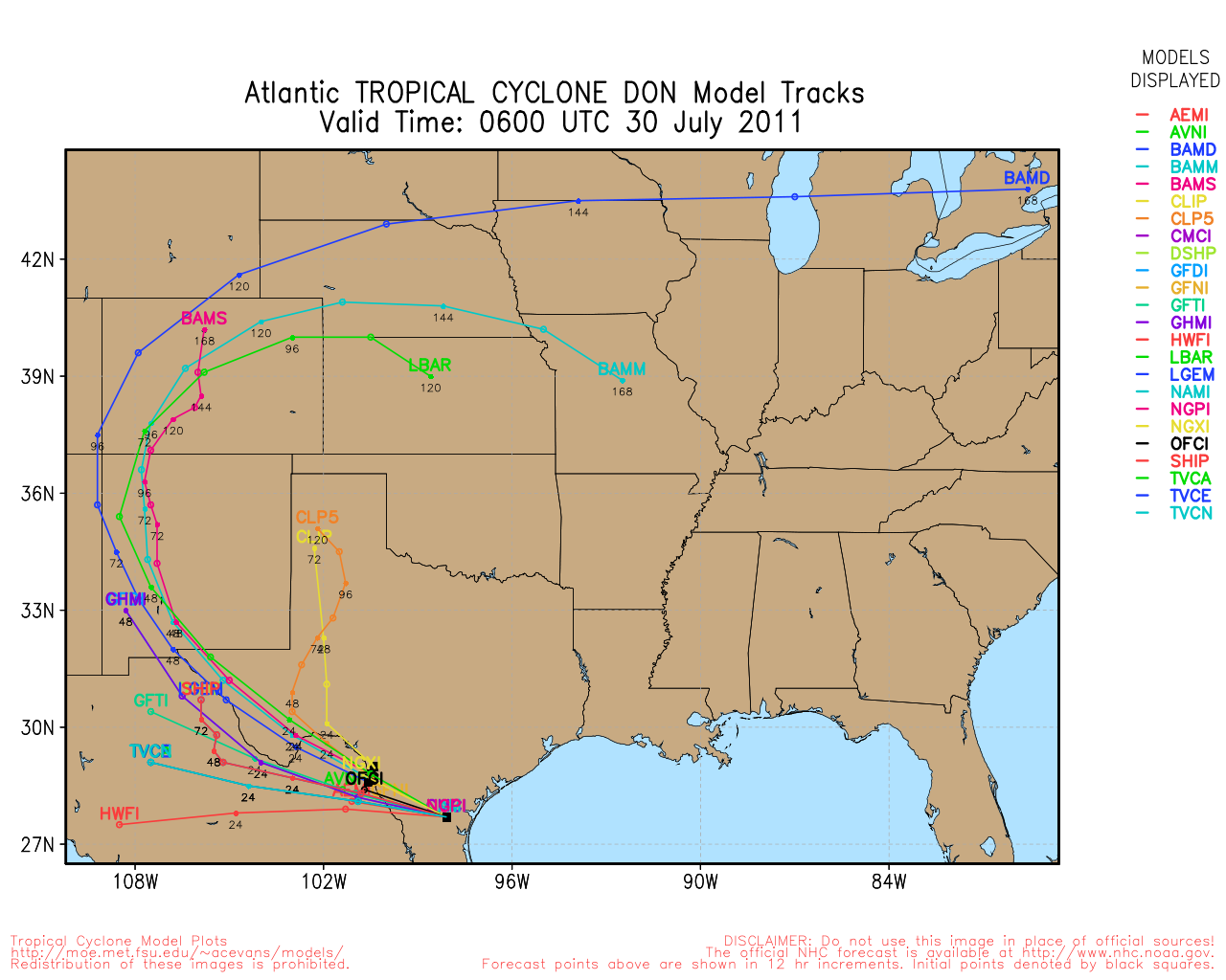
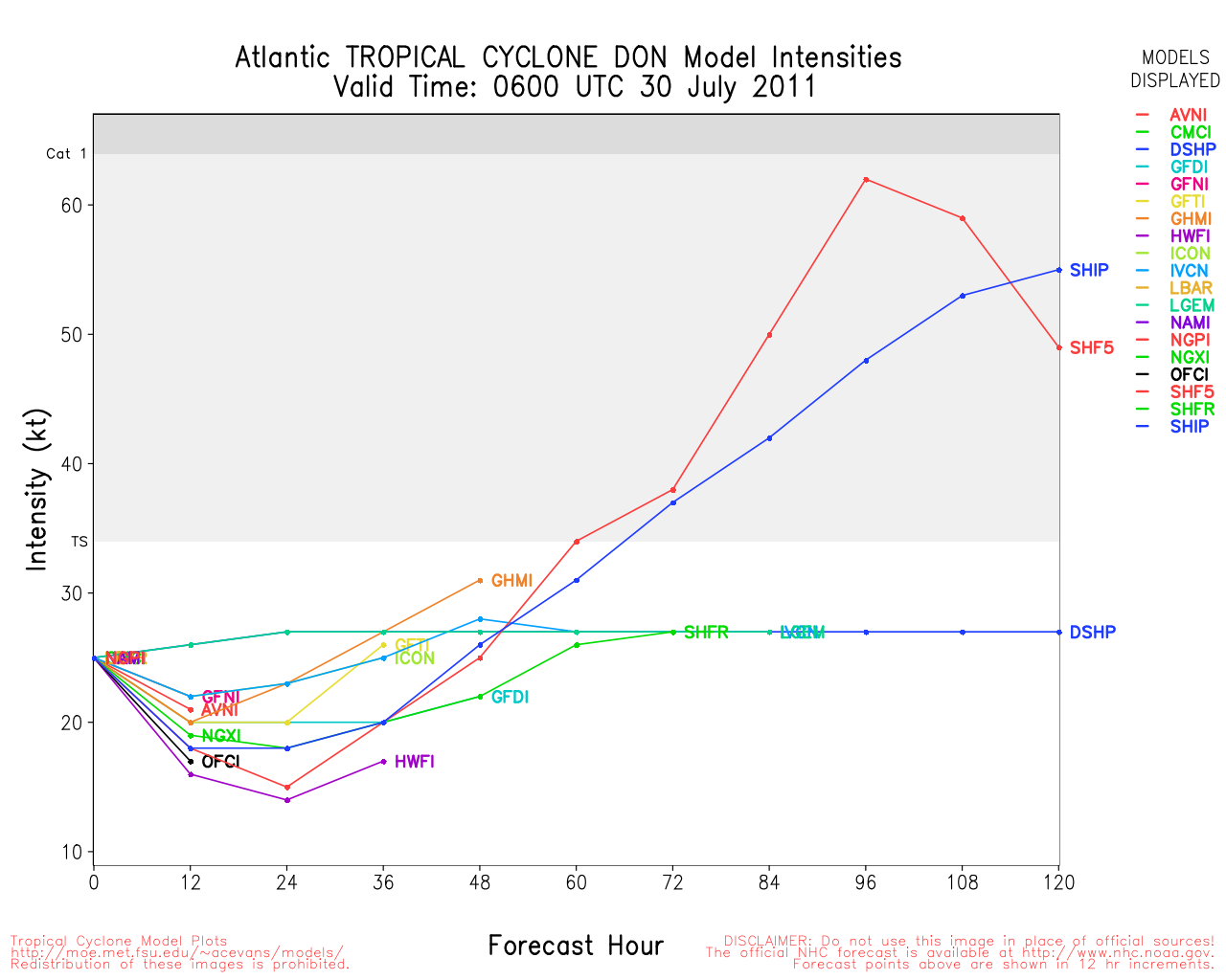
Tropical Storm Don's last day over water is today, and it is expected to make landfall very late tonight into tomorrow morning, probably in Kenedy county, TX, or just north of Brownsville. If the system sees any more movement to the west than expected, points in extreme Northeast Mexico could also go under a Tropical Storm Warning.
The system still is being sheared, and still has to deal with dry air, which will likely keep it from strengthening too much. Some strengthening is expected before landfall, but the limiting factors will keep it from going too high. Although there is a chance that convective bursts may occur as it approaches land so rain could be very heavy in spots.

The rain is being sheared mostly to the south of the system, points north of the center of landfall will not receive as much rain as points south.
Don will be monitored throughout the day, Those in the warning area should know that the hurricane center fully updates Every 6 hours, which includes (Times CST# 5AM, 10AM, 5PM, 10PM, and also issues intermediate advisories when there are watches/warnings up at 7AM, 1PM, 7PM, and 1AM. If a very rapid change were to occur they will issue a special statement #Usually after recon findings#, these are rare, but could happen anytime. So you can schedule checks around those times.
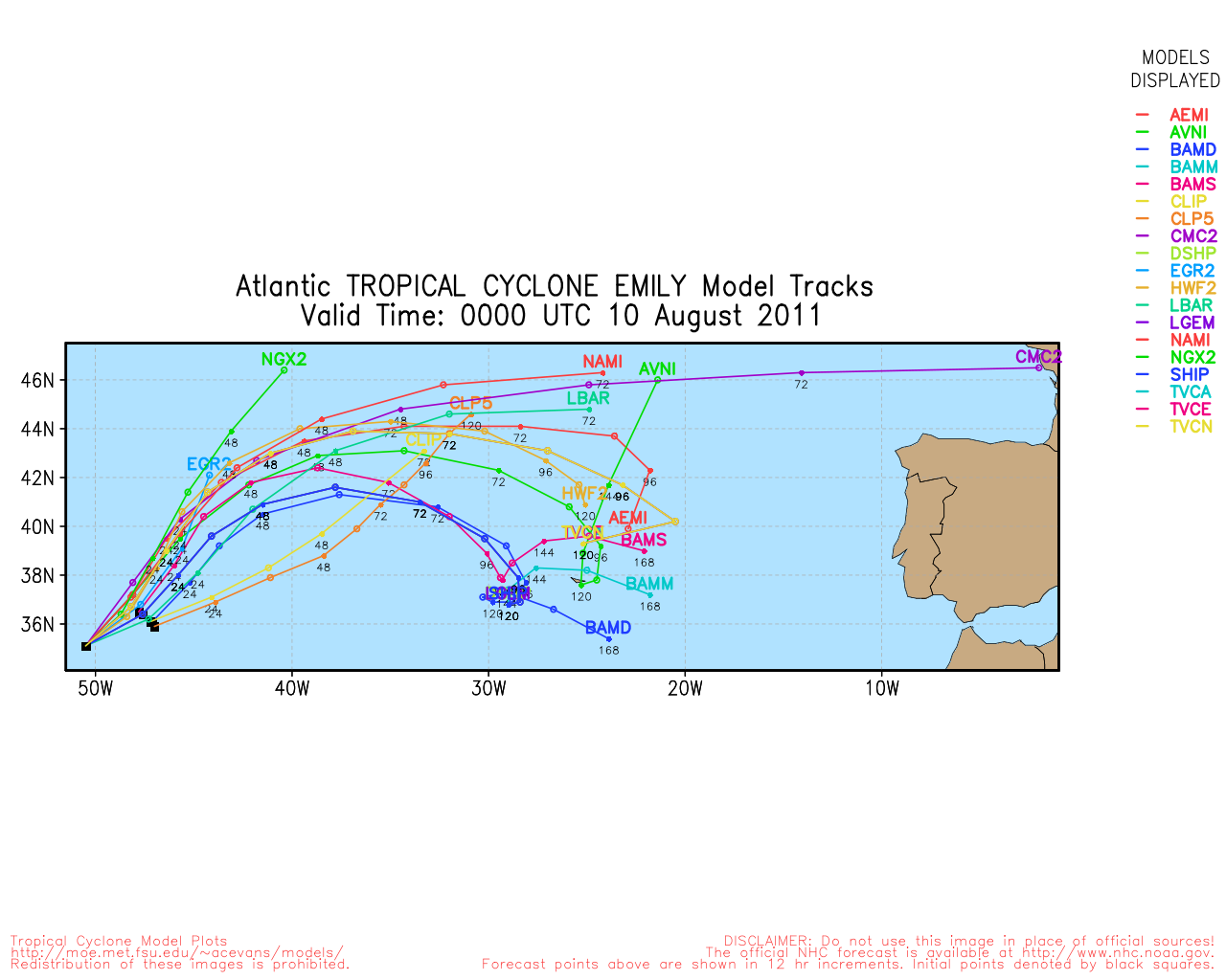
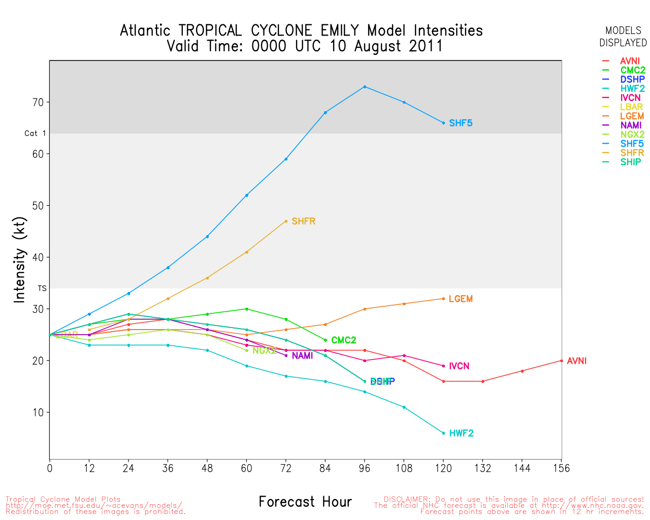
The wave in the Central Atlantic is now being tracked as 91L, it is expected to move into or close to the Caribbean, and has a 30% chance for development. If this were to become a named system before August 1st, it would put us at 5 named storms by the first of August, which has only been topped by the 2005 season recently. For comparison, 2004 the first named storm #Alex# did not form until August 1st.

Those in the Eastern Caribbean islands will want to watch the wave closely as it likely will develop before nearing the islands. This system has very few negative factors and will likely become this year's first hurricane. If so it would be named Emily. There is more speculation on this system in the forecast lounge.
Don Event Related Links


SFWMD Model Plot (Animated Model Plot) SFWMD Hurricane Page
[https://flhurricane.com/floatanimator.php?year=2011&storm=4 Flhurricane Satellite Floater Animation of Don
GOES Floater
Animated Model Plot of Don
Clark Evans Track Model Plot of Don
(Animated!) Model Plots in Google Earth - In Google Maps
Clark Evans Intensity Model Plot of Don (Animated!)
Clark Evans Track Plot of Don
Other Model Charts from Clark
Clark Evans Top 10 Analog Storms for Don
More model runs on from RAL/Jonathan Vigh's page
NRL Info on Don -- RAMMB Info
COD Atlantic Satellite View
91L Event Related Links


SFWMD Model Plot (Animated Model Plot) SFWMD Hurricane Page
[https://flhurricane.com/floatanimator.php?year=2011&storm=5 Flhurricane Satellite Floater Animation of 91L
GOES Floater
Animated Model Plot of 91L
Clark Evans Track Model Plot of 91L
(Animated!) Model Plots in Google Earth - In Google Maps
Clark Evans Intensity Model Plot of 91L (Animated!)
Clark Evans Track Plot of 91L
Other Model Charts from Clark
Clark Evans Top 10 Analog Storms for 91L
More model runs on from RAL/Jonathan Vigh's page
NRL Info on 91L -- RAMMB Info
COD Atlantic Satellite View
Level 3 Radar/ Don Approach South Texas #HCW# flhurricane recording
Texas Gulf Coast Links
[http://moe.met.fsu.edu/~mnissenbaum/radar.html Mark Nissenbaum's radar page}
East to West:
Houston/Galveston, TX Radar Radar Loop
(Latest Static)
Corpus Christi, TX Radar Radar Loop
(Latest Static)
Brownsville, TX Radar Radar Loop
(Latest Static)
Gulf of Mexico Satellite Imagery
Area Forecast Discussions:
Houston/Galveston, TX
- Corpus Christi, TX - Browsnville/South Padre Island, TX
Long Term Floater Recordings of Don:
Visible Floater Recording of Don
Water Vapor Floater Recording of Don
Rainbow IR Floater Recording of Don
Don Approach Related Links:
Color Sat of Gulf
Emergency Management:
Texas Division of Emergency Management
Texas Emergency Management Reports
AEP Texas Power Outage Map
Local Media/Television
Corpus Christi:
KRIS TV 6 #NBC Corpus Christi#
KZTV 10 #CBS Corpus Christi#
KIII TV 3 #ABC Corpus Christi)
Brownsville:
KGBT 4 News Brownsville
KRGV Newschannel 5 Brownsville
KURV 710 News/Talk Brownsville
Houston:
KHOU the CBS affiliate in houston, is former Hurricane Center director Neil Frank's station, and likely will begin streaming once warnings are up in the area
Channel 2 NBC affiliate in Houston
ABC 13 in Houston
Houson Fox 26
Radio
KTRH Rado News/Talk station in Houston with streaming
Other Houston area radio
Newspapers
Corpus Christi Caller-Times
Houston Chronicle
Brownsville Herald
The Monitor
Valley Morning Star
StormCarib Reports from the Caribbean Islands
Caribbean Weather Observations
Barbados Brohav Weather Fax
Full Caribbean Radar Composite
Caribbean Broadcast Corporation (TV/Radio from Antilles)
San Juan, PR NWS Page
Various Caribbean Radio Stations
DR1 Dominican Republic Hurricanes
Edited by Ed Dunham (Fri Jul 29 2011 08:21 PM)
 Threaded


