MikeC
Admin
Reged: Sun
Posts: 4543
Loc: Orlando, FL
|
|
Update 8:00AM EDT 15 Aug 2013
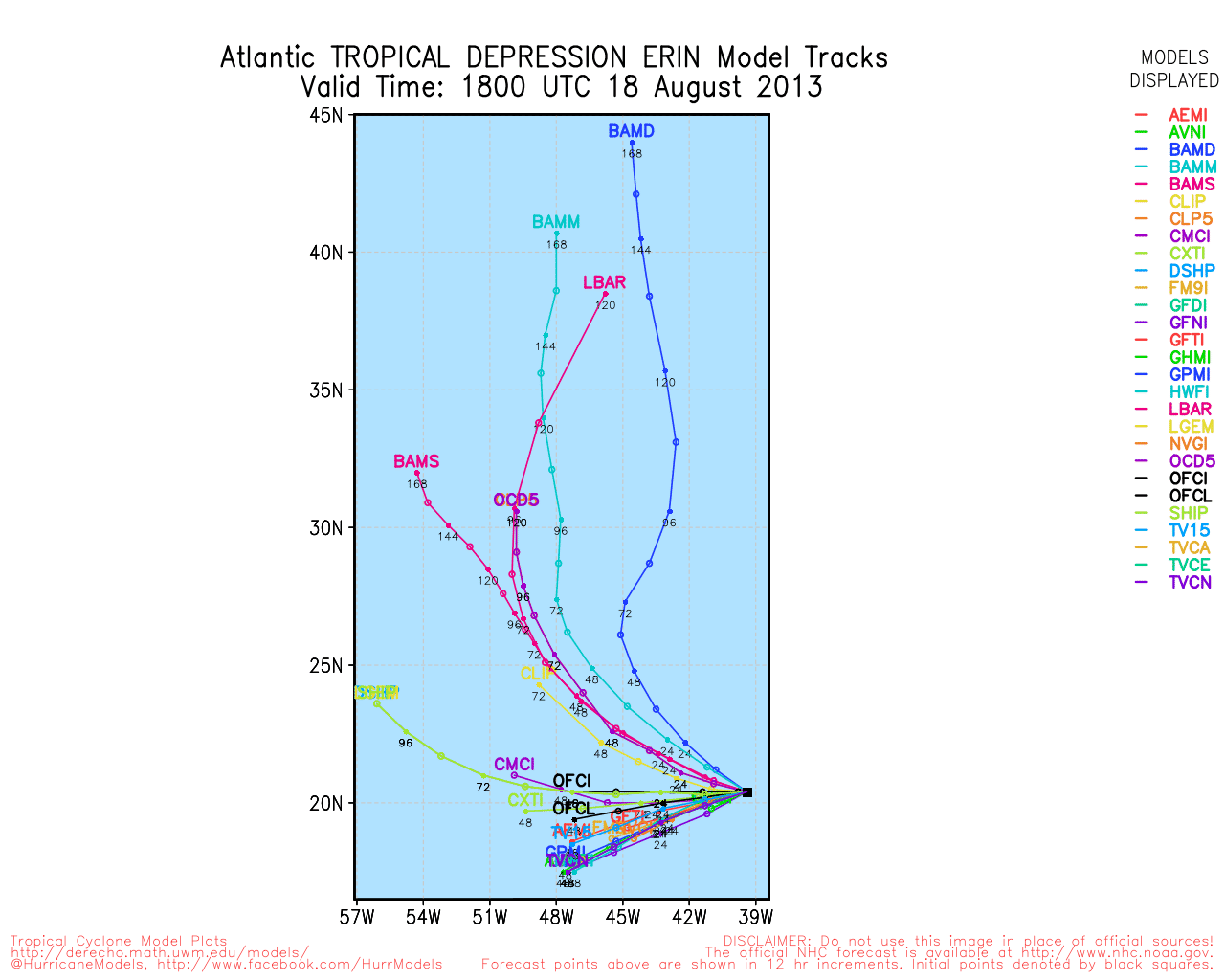
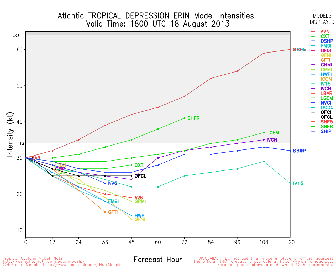
Tropical Storm Erin formed from TD#5 in the far east Atlantic, of the options talked about in the earlier one, it's leaning toward moving more west and possibly dissipating rather than the northerly route. It will have a lot of hostile conditions to go through to hang on, and the main watch for this is to see how much it persists through it.

The wave in the west Caribbean is very much elongated this morning, and will likely remain weak, as some energy moves to the west, and parts stream to the north. If it does form, it will likely remain weak due to an upper area of low pressure in the central Gulf.
Update 10:30PM EDT 14 Aug 2013
Still a bit of disagreement in the forecast for 92L if it moves west, more northerly, or splits/elongates. The latter is the most likely. Which would, along with shear and other poor conditions, keep it relatively weak. Still worth watching over the next few days, but it looks unlikely to develop before it reaches the Yucatan at this point.
Updated 2:30PM EDT 14 Aug 2013
After a few quiet weeks post Dorian, the usual ramp up of storm activity in mid to late August is nearly upon us, and this year seems to be no exception.
There are two waves worth watching this week, 92L in the west Caribbean which may form toward the weekend, but likely will remain weak. This will be worth watching as it moves into the Gulf of Mexico. Those in the Yucatan peninsula may have to do with rain and stormy conditions Thursday and Friday. Future track depends on what occurs in the short term, odds favor it moving into Mexico, but there is a chance that it could veer more northerly and enter the central Gulf. There is a chance the storm will split or be elongated, which would likely keep it weaker. Either way most of the Gulf will want to watch this over the next few days, in particular the Northeast Gulf from LA to the Florida Panhandle basic on the forecast trends that have occurred since this morning.
Recon is scheduled to check out this area tomorrow. It is mid August and things can change rapidly with systems in this area this time of year, so check in on it often, and this system is an extremely difficult forecast with evidence to support both west and northerly movement of the system.
The other is 93L well in the east Atlantic, which will have time to be watched as it moves generally westward, odds favor it it staying out to sea or dissipating, but persistence is the key on these waves. Since earlier this system indeed has become better organized and may develop within the next few days, if not later tonight.
North Gulf Links
North Gulf/Southern Mississippi Valley Composite Radar Loop
(Latest Static)
East to West:
Mobile, AL Radar Radar Loop
(Latest Static)
New Orleans, LA Radar Radar Loop
(Latest Static)
Lake Charles, LA Radar Radar Loop
(Latest Static)
Houston/Galveston, TX Radar Radar Loop
(Latest Static)
Gulf of Mexico Satellite Imagery
Area Forecast Discussions:
Mississippi/Alabama/Pensacola -
New Orleans, LA -
Lake Charles, LA -
Houston/Galveston, TX
Northeast Gulf Links
Southeast Composite Radar Loop
(Latest Static)
Tampa Bay, FL Radar Radar Loop
(Latest Static)
Key West, FL Radar Radar Loop
(Latest Static)
Mobile, AL Radar Radar Loop
(Latest Static)
Tallahassee FL Radar Radar Loop
(Latest Static)
Northwest Florida Radar Radar Loop
(Latest Static)
Gulf of Mexico Satellite Imagery
SFWMD Full Florida Radar (Includes east LA, MS,AL) Loop with Storm Track
Area Forecast Discussions:
New Orleans -
Mississippi/Alabama/Pensacola -
Panhandle/Tallahassee -
Tampa/West Central Florida
Erin Event Related Links


SFWMD Model Plot (Animated Model Plot) SFWMD Hurricane Page
[https://flhurricane.com/floatanimator.php?year=2013&storm=5 Flhurricane Satellite Floater Animation of Erin
GOES Floater
Animated Model Plot of Erin
Clark Evans Track Model Plot of Erin
(Animated!) Model Plots in Google Earth - In Google Maps
Clark Evans Intensity Model Plot of Erin (Animated!)
Clark Evans Track Plot of Erin
Other Model Charts from Clark
Clark Evans Top 10 Analog Storms for Erin
More model runs on from RAL/Jonathan Vigh's page
NRL Info on Erin -- RAMMB Info
COD Atlantic Satellite View
}
Yucatan Wave (92L) Event Related Links


SFWMD Model Plot (Animated Model Plot) SFWMD Hurricane Page
[https://flhurricane.com/floatanimator.php?year=2013&storm=6 Flhurricane Satellite Floater Animation of 92L
GOES Floater
Animated Model Plot of 92L
Clark Evans Track Model Plot of 92L
(Animated!) Model Plots in Google Earth - In Google Maps
Clark Evans Intensity Model Plot of 92L (Animated!)
Clark Evans Track Plot of 92L
Other Model Charts from Clark
Clark Evans Top 10 Analog Storms for 92L
More model runs on from RAL/Jonathan Vigh's page
NRL Info on 92L -- RAMMB Info
COD Atlantic Satellite View
|
berrywr
Weather Analyst

Reged: Fri
Posts: 387
Loc: Opelika, AL
|
|
I will cover 92L on our Facebook page for the time being. 93L is so far out there it might as well be in the Indian Ocean. I will focus on 92L only until at least GOES East has eyes on it. As of this typing there is no model consensus.
--------------------
Sincerely,
Bill Berry
"Survived Trigonometry and Calculus I"
|
Wingman51
Weather Guru

Reged: Tue
Posts: 126
Loc: Orlando, FL
|
|
What is the FB page so we can link - - Thanks
|
Tazmanian93
Weather Master

Reged: Sun
Posts: 495
Loc: Tampa
|
|
https://www.facebook.com/pages/Flhurricanecom/91063554398?ref=stream&hc_location=timeline
--------------------
Don't knock the weather; nine-tenths of the people couldn't start a conversation if it didn't change once in a while.
Go Bucs!!!!!!!!!
****************
Ed
|
MikeC
Admin
Reged: Sun
Posts: 4543
Loc: Orlando, FL
|
|
Bill handles most of the facebook updates, but some information gets pasted from this site automated. And others we add ourselves.
That said, watch 92L, this time of August is ripe for unexpected and rapid changes in the tropics in this area. The entire Gulf (especially Northeast Gulf) should be checking in on this every 6 hours or so. Things are flipped flopped from last night, and now it forecast favors the more northerly track. It's likely to be a sheared tropical system, if so.
|
Joeyfl
Weather Guru
Reged: Mon
Posts: 133
Loc: St.Pete,FL
|
|
92L in western Caribbean really coming to life now. Looks to be very close to TD/TS status. I would really keep an eye on this one especially those from New Orleans to Big bend of FL. Like Mike said this area has to be watched this time of year for quick development especially given low shear, and abundant oceanic heat in this area. Will be interesting to see if we get a TD or TS sooner rather than later given its rather impressive organization it has undertaken this afternoon...
|
Hawkeyewx
Weather Analyst
Reged: Sun
Posts: 99
|
|
92L has had some nice persistent convection today, but the surface flow is still disorganized with the wave axis being out ahead of the convection.
|
berrywr
Weather Analyst
Reged: Fri
Posts: 387
Loc: Opelika, AL
|
|
West moving Tropical Waves always have their negative vorticity out in front of the axis and positive vorticity behind the axis. In the upper level and dynamic systems moving west to east...generally positive is out ahead of the trough/front axis and negative behind...so looking at it; negative is always on left side of any trough axis, positive on the right regardless of what direction it is moving but that's not always the case especially in higher latitudes where upper lows generally rotate around a broader low. Just remember in the tropics, the action is behind the wave, not in front....
--------------------
Sincerely,
Bill Berry
"Survived Trigonometry and Calculus I"
|
berrywr
Weather Analyst
Reged: Fri
Posts: 387
Loc: Opelika, AL
|
|
I just updated the Facebook page...yesterday the was the outlier; today it's 50-50 and the has shifted further north. Keep an eye on the upper level trough situated over the eastern US and look for it to retrograde westward; Currently there is an upper low in the South Central Gulf of Mexico squarely centered between the upper ridge over South Central US and another upper ridge over Central Cuba...at 300 millibars there is a clear trough axis in the extreme southern GOM and excellent upper air difluence between it and the upper ridge over Cuba that has enhanced convective elements of 92L. I didn't post that low in my discussion but the has had a good handle on it now for a few days; it can't be dismissed and the CIMMS Tropical website is down so I don't have access to the shear analysis but I'm not convinced that down the road this will be a pure tropical cyclone given the upper air environment.
--------------------
Sincerely,
Bill Berry
"Survived Trigonometry and Calculus I"
|
danielw
Moderator

Reged: Wed
Posts: 3525
Loc: Hattiesburg,MS (31.3N 89.3W)
|
|
I find it rather interesting that the Canadian model 12Z run of today is a hard left turn from yesterday's 12Z run.
Yesterday's projected landfall was in the Pensacola,FL area and today's projected landfall from the same model is Tampico,MX / Brownsville,TX.
That's a miss the trough solution to me.
But the model today also does a small loop-de-loop in the BOC before moving toward Tampico / Brownsville.
|
Random Chaos
Weather Analyst

Reged: Sat
Posts: 1024
Loc: Maryland
|
|
Both invests are now up to 80% chance of development over the next 5 days (Gulf invest is 70% for the next 2 days, the other 80%). The season sure got off to a slow start, but it now looks to be giving itself a kick. is shifting strongly toward the Atlantic in virtually all forecast models.
Ref: http://www.cpc.ncep.noaa.gov/products/precip/CWlink/MJO/CLIVAR/clivar_wh.shtml
|
ralphfla
Weather Watcher
Reged: Wed
Posts: 26
|
|
the latest runs are now showing going to mexico and not really becoming much. I think this is a no event
|
danielw
Moderator
Reged: Wed
Posts: 3525
Loc: Hattiesburg,MS (31.3N 89.3W)
|
|
Quote:
the latest runs are now showing going to mexico and not really becoming much. I think this is a no event
Just remember.
1. Don't turn your back on a tropical system until it is Onshore.... somewhere.
2.Or north of your latitude.
3.Second rule doesn't always work.
|
ralphfla
Weather Watcher
Reged: Wed
Posts: 26
|
|
when it becomes a event as of now it is a wave that is it. Nobody said look away just no need to over do it
|
Random Chaos
Weather Analyst
Reged: Sat
Posts: 1024
Loc: Maryland
|
|
There is one more to add to Daniel's list:
4. Any model run before it becomes at least a Tropical Storm is more than likely the wrong track. Throw it out and roll the dice instead.
Models just don't initialize tropical cyclones well until they have formed. Therefore there is a statistical chance a model track "could" be correct, but that will be more than likely coincidence, not model accuracy, at this point. Once it becomes a Tropical Storm, plus 6-12 hours for model run data ingest, and you will start having somewhat reliable tracks. Add in a few hurricane hunters, and then you have a fairly reliable track.
One problem with early models is that a tropical wave is a semi-normal low pressure system steered by shallow layers of the atmosphere in a regional dynamic. A tropical cyclone, however, is a much deeper storm, and in addition to affecting the regional dynamic directly, gets steered by deeper layers of the atmosphere. Unless the model correctly models the depth of the storm (which I have almost never seen them do), they will be highly inaccurate.
|
ralphfla
Weather Watcher
Reged: Wed
Posts: 26
|
|
I know these things and i also know right now it is much ado about nothing. It is not a depression even yet let alone a storm and the models most do not show it making it so again it is a non event till it even becomes something to be a event about.
|
weatherguy08
Weather Hobbyist
Reged: Thu
Posts: 60
Loc: Miami, Fla.
|
|
Don't forget also that recon is flying AL92 tomorrow, and that data will be ingested into the models (maybe starting with the 16/00Z runs?), so that'll make a big difference.
Looking at the forecast, take a gander at the 15/00Z 500 mb analysis from SPC: http://www.spc.noaa.gov/obswx/maps/500_130815_00.gif
There is a series of shortwave troughs over the northern : one over eastern Nebraska and the other over eastern Montana. These shortwave troughs will act to amplify the longwave trough over the east coast and allow the ridge over the western to build, which will result in a col (a saddle point in the wind/pressure field) being set up over the Gulf of Mexico. These tend to result in two things: (1) weak steering currents, and (2) low model predictability. Since the aforementioned longwave trough amplification will result in large-scale height falls over the eastern half of the US with height rises over the western/central US, my thinking is that the northern models will win the day in the end, meaning people from Corpus Christi to Pensacola are probably the most under the gun. This general idea is what the and have been suggesting for the past few runs.
--------------------
Jason
http://www.jasonsweathercenter.com
Andrew '92 - Lili '02 - Katrina '05 - Rita '05 - Humberto '07 - Gustav '08 - Ike '08 - Isaac '12 - Sandy '12
|
berrywr
Weather Analyst
Reged: Fri
Posts: 387
Loc: Opelika, AL
|
|
This is the 500 millibar analysis chart with plots that one hasn't changed in 40 years and two, is the best of the best tool in the meteorologist or forecaster's arsenal. The plot analysis is the one you want.
http://weather.noaa.gov/fax/barotrop.shtml
--------------------
Sincerely,
Bill Berry
"Survived Trigonometry and Calculus I"
|
doug
Weather Analyst
Reged: Mon
Posts: 1006
Loc: parrish,fl
|
|
Brief comment based on the morning view from space. An upper level cyclonic flow is to the NW of this system and that seems increasing. A may be forming. There is no question that this has impacted the system and split the moisture envelope as the northern and eastern portion are now being shifted northward and the rest continues toward Belize. This type of set up has killed the previous two surface features coming up out of the Caribbean. The key today will be the influence of this dynamic on the future path and development of that surface low. Frankly I give it a low chance if that upper feature continues and virtually no chance if it strengthens.
--------------------
doug
Edited by doug (Thu Aug 15 2013 07:25 AM)
|
MikeC
Admin
Reged: Sun
Posts: 4543
Loc: Orlando, FL
|
|
The Recon scheduled to investigate 92L today was cancelled.
|
 Threaded


