cieldumort
Moderator

Reged: Mon
Posts: 2305
Loc: Austin, Tx
|
|
9:15 AM EDT 4 August 2014 Update
Tropical Storm Bertha is now a 70 MPH Storm, and forecast to become a hurricane later today or tomorrow. Beyond rip current and high waves along the coast, Bertha should stay offshore.
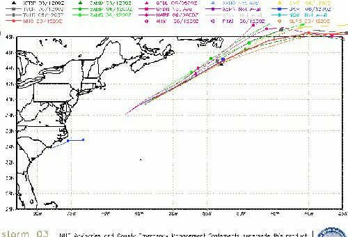
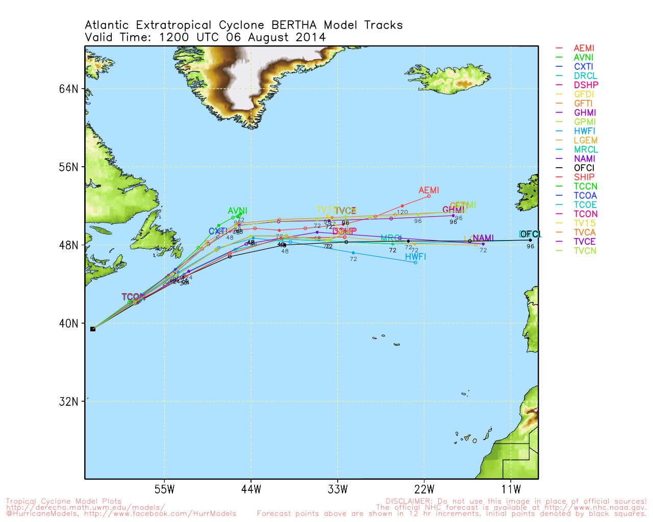
Bertha is forecast to remain away from land both the US and Bermuda. Toward the end of the forecast, parts of Newfoundland are in the Cone.
Models may drift a bit west today, but still should be well offshore.
Canadian Hurricane Centre
8:30 PM EDT 1 August 2014 Update

Bertha has pressed on through another day of marginal support, at best, during the day Friday, as a poorly organized tropical storm.
As of 8:30 PM EDT, recon has found just enough wind to support the current advisory of 50MPH. In addition, convection began firing right over the LLC late this afternoon, and continues to do so tonight, as Bertha finally appears to be traveling within a zone of at least temporarily lower wind shear, as well as traveling over warmer waters. Thus, it is possible that strengthening resumes overnight tonight.
Saturday, deteriorating conditions are expected in Puerto Rico and the US Virgin Islands, but this is not all bad. Much of the Antilles has been struggling with moderate to severe rainfall deficits.
Ciel
7:30 AM EDT 1 August 2014 Update
August begins with Bertha east of the Caribbean, but she is very sheared. The 's current forecast seems good. Bertha will likely stay a Tropical Storm (and fluctuate a bit up and down) over the next few days. The Watch/Warning areas should expect Tropical Storm conditions and rain.
The first areas to see gusts toward tropical storm force are in Martinique and St Lucia later this morning.

Beyond the islands Bertha may approach the eastern Bahamas, but eventually likely will curve out to sea.
French Antilles Radar Recording of Bertha Approach Alt player
Barbuda Radar Recording of Bertha Approach Alt player
Original Update
Just enough deep convection has developed just about atop of the low level circulation of 93L that has concluded sufficient organization now warrants an upgrade of the system to Tropical Storm Bertha. Maximum sustained winds are estimated to be 45MPH, with higher gusts.
Tropical Storm Warnings are now in effect for Barbados, St. Lucia & Dominica.
Tropical Storm Watches are now in effect for Puerto Rico, Vieques, Culebra, U.S. Virgin Islands, St Vincent & the Grenadines.
Ciel
Caribbean Islands Weather Reports
Antilles Weather Radar
StormCarib Reports from the Caribbean Islands
Caribbean Weather Observations
Barbados Brohav Weather Fax
Full Caribbean Radar Composite
Caribbean Broadcast Corporation (TV/Radio from Antilles)
San Juan, PR NWS Page
Various Caribbean Radio Stations
DR1 Dominican Republic Hurricanes
Bertha Event Related Links

SFWMD Model Plot (Animated Model Plot) SFWMD Hurricane Page
[https://flhurricane.com/floatanimator.php?year=2014&storm=3 Flhurricane Satellite Floater Animation of Bertha
GOES Floater
Animated Model Plot of Bertha
Clark Evans Track Model Plot of Bertha
(Animated!) Model Plots in Google Earth - In Google Maps
Clark Evans Intensity Model Plot of Bertha (Animated!)
Clark Evans Track Plot of Bertha
Other Model Charts from Clark
Clark Evans Top 10 Analog Storms for Bertha
More model runs on from RAL/Jonathan Vigh's page
NRL Info on Bertha -- RAMMB Info
COD Atlantic Satellite View
Edited by MikeC (Mon Aug 04 2014 09:22 AM)
|
MikeC
Admin
Reged: Sun
Posts: 4543
Loc: Orlando, FL
|
|
Added two radar recordings for Bertha:
French Antilles Radar Recording of Bertha Approach Alt player
Barbuda Radar Recording of Bertha Approach Alt player
|
cieldumort
Moderator
Reged: Mon
Posts: 2305
Loc: Austin, Tx
|
|
Recon is currently finding both pressure and wind fluctuating. Bertha may have been a little stronger, certainly better organized, overnight, but the current operational advisory max sustained wind of 50 MPH looks good for now.
Mid-day, Bertha is barely holding on structurally. Between wrestling with an abundance of dry air - even SAL - her entire span, and the fact that she is now also racing headlong into moderate westerly shear, there is still probably about a 40% chance of her fully opening into a tropical wave by Monday night. Either way, locations along her path will experience blustery, squally, wet weather, and for many of the islands suffering from significant rain deficits, this will be welcome relief.
As of 11:45 AM EDT, the exposed center of Bertha is about 90 mi. east of Martinique, and booking WNW at around 20. Most of the storm's wind and rain may actually not be felt until the center passes, as the convection has been well displaced to the east.
|
danielw
Moderator

Reged: Wed
Posts: 3525
Loc: Hattiesburg,MS (31.3N 89.3W)
|
|
Bertha is moving south of the forecast model tracks. Interests in the Greater Antilles, Turks and Caicos Islands and the Bahamas should frequently check the current status and direction of movement of Tropical Storm Bertha.
Bertha is currently about 90 miles south of St Croix and moving just slightly north of due west. Maximum sustained winds are near 50 mph.
|
Hawkeyewx
Weather Analyst
Reged: Sun
Posts: 99
|
|
Looking at the visible loop this morning, it appears Bertha has lost the well-defined circulation. All I'm seeing is a sharp wave with broad rotation. Maybe recon can find a tiny spot of light west wind near the center, but even if they can it's barely hanging on as a tropical cyclone. The upcoming interaction with land won't help any.
|
cieldumort
Moderator
Reged: Mon
Posts: 2305
Loc: Austin, Tx
|
|
In a mixed blessing, so much Bertha rain is occurring over Puerto Rico that Flash Flood Warnings are already going up.
THE NATIONAL WEATHER SERVICE IN SAN JUAN HAS ISSUED A
* FLASH FLOOD WARNING FOR...
THE FOLLOWING MUNICIPALITIES
IN PUERTO RICO
CANOVANAS
CEIBA
NAGUABO
FAJARDO
LUQUILLO
RIO GRANDE
* UNTIL 1245 PM AST
As of 10 AM EDT, Bertha may or may not be devolving into a wet and windy open wave. A careful analysis of cloud, precip, ocean wave and wind data does suggest this as a strong possibility. It is also noteworthy that the strongest thunderstorms have been located about 100 miles to the SSE of Ponce, P.R., and within this cluster a mid-level rotation may be attempting to work its way to the surface, which might help reposition Bertha somewhat south and a little east of her extrapolated coordinates.
If either situation, or both, verifies (open wave/center relocation to the south), Bertha could end up tracking further west than presently forecast.
|
|
 Threaded


