8:30 PM EDT 1 September 2018 Update

Original Entry
After an especially subdued August in the Atlantic, which can occur with the month of September still ending up very active (See 1961 2002 and 2003), we start the new month with conditions for development much different than last, with considerably warmer SSTs in the Tropical Atlantic, and far less inhibiting Saharan dust over the entire North Atlantic. In addition, African Easterly Waves appear to be lining up.
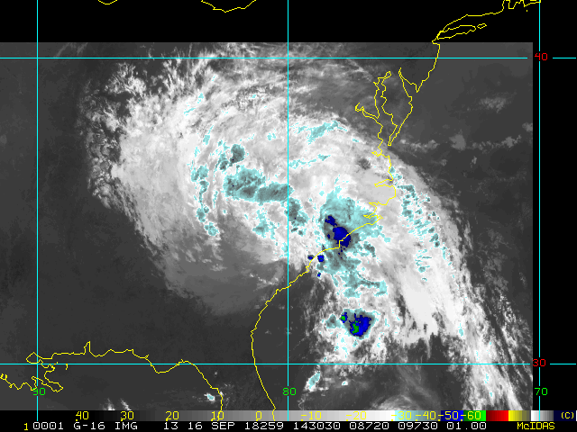
So it goes without saying that because we got a break in August is by no means reason to let ones guard down as we now enter the very climatological peak of the Atlantic Hurricane Season. And as climatology would have it, we are now watching one tropical storm in the far eastern Atlantic (Florence) and a tropical wave set to enter what could be a fairly favorable state in the Gulf of Mexico next week.
Interesting model outputs on both of these, and with reason to keep watch. You can read and discuss more on the model runs of both in the Forecast Lounge:
Tropical Storm Florence Forecast Lounge and also Labor Day Week Gulf Low Forecast Lounge
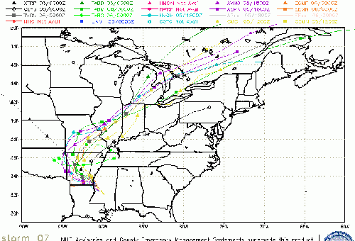
Gordon Event Related Links
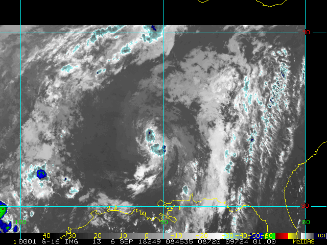
SFWMD Model Plot (Animated Model Plot) SFWMD Hurricane Page
[https://flhurricane.com/floatanimator.php?year=2018&storm=7 Flhurricane Satellite Floater Animation of Gordon
GOES Floater
Animated Model Plot of Gordon
Clark Evans Track Model Plot of Gordon
(Animated!) Model Plots in Google Earth - In Google Maps
Clark Evans Intensity Model Plot of Gordon (Animated!)
Clark Evans Track Plot of Gordon
Other Model Charts from Clark
Clark Evans Top 10 Analog Storms for Gordon
More model runs on from RAL/Jonathan Vigh's page
NRL Info on Gordon -- RAMMB Info
COD Atlantic Satellite View
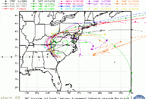
Florence Event Related Links
SFWMD Model Plot (Animated Model Plot) SFWMD Hurricane Page
[https://flhurricane.com/floatanimator.php?year=2018&storm=6 Flhurricane Satellite Floater Animation of Florence
GOES Floater
Animated Model Plot of Florence
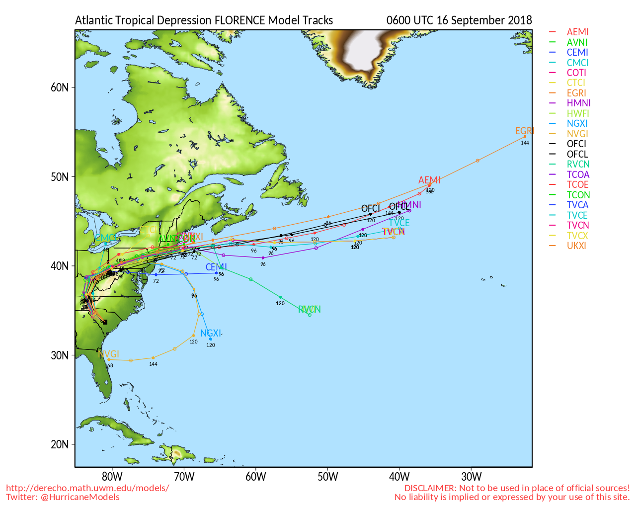
Clark Evans Track Model Plot of Florence
(Animated!) Model Plots in Google Earth - In Google Maps
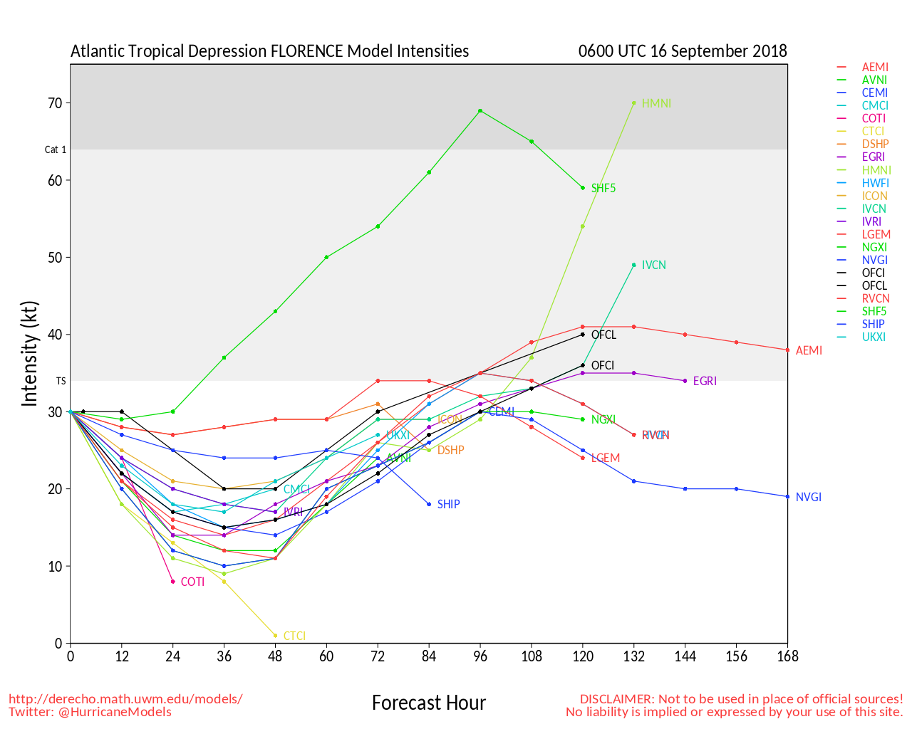
Clark Evans Intensity Model Plot of Florence (Animated!)
Clark Evans Track Plot of Florence
Other Model Charts from Clark
Clark Evans Top 10 Analog Storms for Florence
More model runs on from RAL/Jonathan Vigh's page
NRL Info on Florence -- RAMMB Info
COD Atlantic Satellite View
East Florida Links
Southeast Composite Radar Loop
(Latest Static)
South to North:
Key West, FL Radar Radar Loop
(Latest Static)
Miami, FL Radar Radar Loop
(Latest Static)
Melbourne, FL Radar Radar Loop
(Latest Static)
Jacksonville, FL Radar Radar Loop
(Latest Static)
Caribbean/South East Coast Satellite Imagery
SFWMD Radar Loop of South Florida with storm Track
SFWMD Full Florida Radar Loop with Storm Track
Area Forecast Discussions:
FLorida Keys -
Miami/South Florida -
Melbourne/East Central Florida -
Jacksonville/Northeast Florida -
Northeast Gulf Links
Southeast Composite Radar Loop
(Latest Static)
Tampa Bay, FL Radar Radar Loop
(Latest Static)
Key West, FL Radar Radar Loop
(Latest Static)
Mobile, AL Radar Radar Loop
(Latest Static)
Tallahassee FL Radar Radar Loop
(Latest Static)
Northwest Florida Radar Radar Loop
(Latest Static)
Gulf of Mexico Satellite Imagery
SFWMD Full Florida Radar (Includes east LA, MS,AL) Loop with Storm Track
Area Forecast Discussions:
New Orleans -
Mississippi/Alabama/Pensacola -
Panhandle/Tallahassee -
Tampa/West Central Florida
North Gulf Links
North Gulf/Southern Mississippi Valley Composite Radar Loop
(Latest Static)
East to West:
Mobile, AL Radar Radar Loop
(Latest Static)
New Orleans, LA Radar Radar Loop
(Latest Static)
Lake Charles, LA Radar Radar Loop
(Latest Static)
Houston/Galveston, TX Radar Radar Loop
(Latest Static)
Gulf of Mexico Satellite Imagery
Area Forecast Discussions:
Mississippi/Alabama/Pensacola -
New Orleans, LA -
Lake Charles, LA -
Houston/Galveston, TX
Edited by MikeC (Mon Sep 03 2018 08:10 AM)
 Threaded


