cieldumort
Moderator

Reged: Mon
Posts: 2305
Loc: Austin, Tx
|
|
9:30 PM EDT 10 September 2018

Florence is undergoing an eyewall replacement cycle tonight, which will temporarily halt deepening (and max wind speed increases - could even weaken a little), but this is a normal part of a mature hurricane's nature, and will likely help lead to an overall increase in size, with pressure falls/wind speed increases resuming after.
There are several things to fear with Florence. Those along and just inland along the coast of her track need to leave evac zones promptly, as the surge potential is deadly high - even well inland (Say nothing of the winds). Those further inland will contend with a prolonged duration catastrophic wind event and inland flooding. Comparisons being made for a potential Hazel or ... that then slows down or even sits in place ... are not hyperbolic.
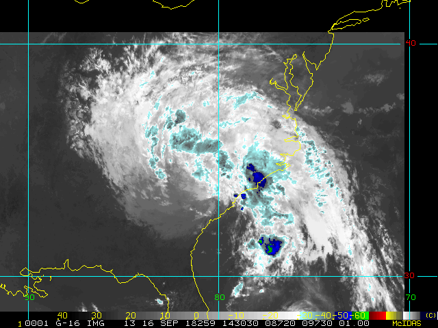
Elsewhere, Invest 95L approaching the west to northwest Gulf of Mexico is odds-on to become a tropical storm, or at least a T.D. And potentially a very wet one. This could bring abundant rain to a portion of the country that has already seen flooding over the past week or so. The next name on the list in the Atlantic is Joyce. Watches and Warnings may be issued at any time.
In the central Pacific, Olivia is now a very strong Tropical Storm, approaching the islands from the east, and likely to make a more-or-less direct hit on the archipelago. The mountains of these islands really squeeze out the precip of even passing afternoon showers, and thus, deadly flash flooding, rock and mudslides are a huge risk.
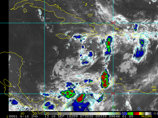
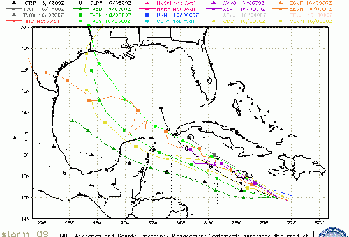
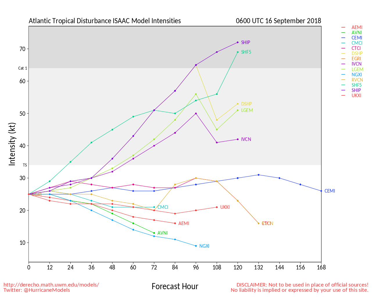
Isaac weakened some today, the smaller cyclone being battered by some shear and in the vicinity of some dry air. Still forecast to impact the Antilles by Thursday night as a very strong tropical storm.
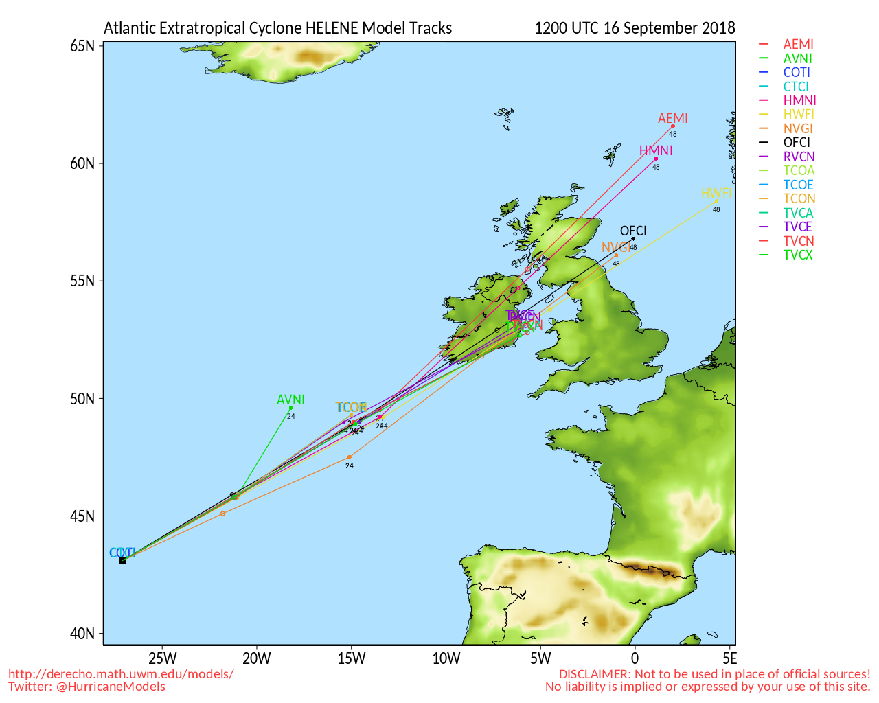
In the far eastern Atlantic, Helene is still expected to turn north away from land, for now.
-Ciel
9:30 PM EDT 9 September 2018
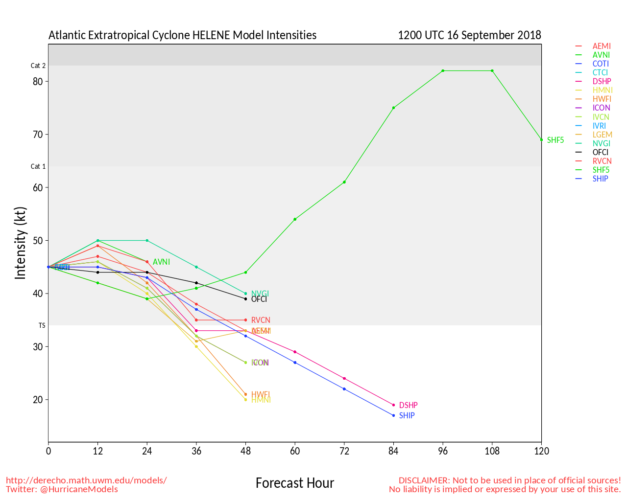
Issac will likely become a hurricane tonight, Helene already did today.
An area in the West Caribbean has a 30% chance to develop in the Gulf of Mexico and may impact Texas late this week.
And area near the Azores has a 40% chance to develop.
Isaac likely will impact the lesser Antilles this week.
Helene is likely to stay out to sea.
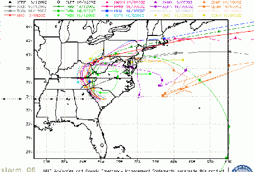
And Florence seems to be zoning in on North Carolina for a major impact Thursday night.

4:30 AM EDT 9 September 2018
Recon dropsonde data from Florence was assimilated by the 0z model runs last night. There is simply no good news that came out from the improved forecasts, outside of increased confidence in the reliability of the forecast. But one which is ugly: the likelihood of a landfalling Major next week somewhere along the southeast coast (and looking more and more like South or North Carolina, but still too early to say for sure - don't even let your guard down just yet in N Florida, Georgia, etc.).
This is a "Red Alert" for those who live in the Cone of Uncertainty. Take all the time you need right now to protect life and property. The forecast is looking increasingly likely. In the event the forecast verifies, the last thing you want is to be rushed.
Elsewhere, dropsonde data was also assimilated into the model runs on Olivia in the eastern Pacific, also resulting only in more confidence of the existing forecast there.
-Ciel
2:00 PM EDT 8 September 2018
Invaluable data from this morning's non-tasked recon mission into the cyclone, timely data from a solid microwave satellite pass, and greatly improved structure in conventional satellite, all suggest that Florence is primed to enter Rapid Intensification. Odds favor an intensification phase ensuing later today, perhaps especially so overnight, and it is not out of the question that Florence is a significant hurricane once again by late tonight, and maybe even a Major by Monday morning.
This improved structure, with better vertical alignment and hints at deepening convection, all point to the cyclone perhaps being able to better feel the gentle pull to round the southwest corner of the High building in to her north and northeast. A slightly rightward (less west) shift in several of the models today has already occurred, and this looks more possible (could be verifying before our very eyes). Now the bad news - the High is still strong and stubborn, and even a trend to the right does not necessarily mean a trip out to sea prior to landfall/s later next week, and no one along the east coast should be letting ones guard down.
-Ciel
8:30 AM EDT 8 September 2018
Florence still generally moving west, and regaining some strength slowly today, but won't really gain much until a few days from now. Models still have a wide spread from Florida to out to sea, but seem to be favoring near the SC/NC border. Shifts are expected, but which direction is unsure. Everyone from Florida to New Jersey should be watching Florence closely. Where will it go? It's all a guess at this point, check out the Forecast Lounge for some thoughts and models.
A NOAA P3 plane is out sampling the air around Florence to help with forecasts starting today.
Helene has prompted a hurricane watch for the Cabo Verde islands with the new forecast.
T#9 is likely to become Isaac sometime today.
Olivia is still forecast to move over the Hawaiian islands as a tropical storm.

6:30 AM EDT 7 September 2018
Florence has weakened overnight, but is forecast to move into a much more favorable area for development in the next 2-3 days. In the meantime that unfortunately means it will likely get to move more west than north (and maybe even slightly south) as the ridging above the system builds.
All of the main 3 model families , Euro, and UKMET that folks are watching have shifted left, more west, with the likelihood of a US impact going up. However it is still too early to tell exactly where the storm will wind up, other than those from Florida all the way to New England should monitor Florence. Only a fraction of the ensembles take it out to sea at this point.
Between Georgia and Virginia in particular is the general area where most of the models converge right now, but that may shift south or north. If the model timelines remain relatively consistent, direct impacts could be felt around Thursday of next week.
Beyond this, both 92L and 93L are at 90% to develop in the next day or so, and those will also need to be watched, but a lot of their future track depends on where Florence winds up.
Two other U.S. threats we are watching - Olivia in the Pacific as a potential threat to Hawaii, and also 26W, which is forecast to hit Guam as a Super Typhoon.
Original Update

September continues producing very high Accumulated Cyclone Energy, or ACE, in both the Atlantic and Central-Eastern Pacific basins, with multiple risks for the U.S. and several of our neighbors. Now that Gordon is well-inland and weakening, but not without a continuing rain threat for the middle of the country, our attention quickly turns to several others potentially just as, if not more, significant tropical threats. The biggest of these being Hurricane Florence in the Atlantic, and Hurricane Olivia in the Pacific.
In the Atlantic, Florence, most recently a powerful Cat 4 Major that is now on a weakening trend in the short term, has the forecasters at doing double time to nail down her future track, with this morning's update shifting more to the west, and a little bit closer to mainland United States.
In the Pacific, Olivia, recently on a strengthening trend again, is forecast to change from her present west-northwestward heading to nearly due west, with increasing concern for potential impacts on the Hawaiian islands early to middle of next week.
Elsewhere, way east in the Atlantic we are also following Invest 92L, which will likely become EIGHT at any time today or tomorrow, as well as yet another vigorous wave about to roll off the west coast of Africa.
Join us in the Forecast Lounge as we delve into analysis of various model outputs on each of these features. We'll see you there!
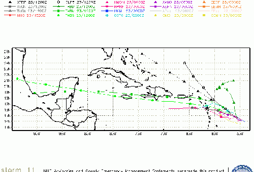
Florence Event Related Links
SFWMD Model Plot (Animated Model Plot) SFWMD Hurricane Page
[https://flhurricane.com/floatanimator.php?year=2018&storm=6 Flhurricane Satellite Floater Animation of Florence
GOES Floater
Animated Model Plot of Florence
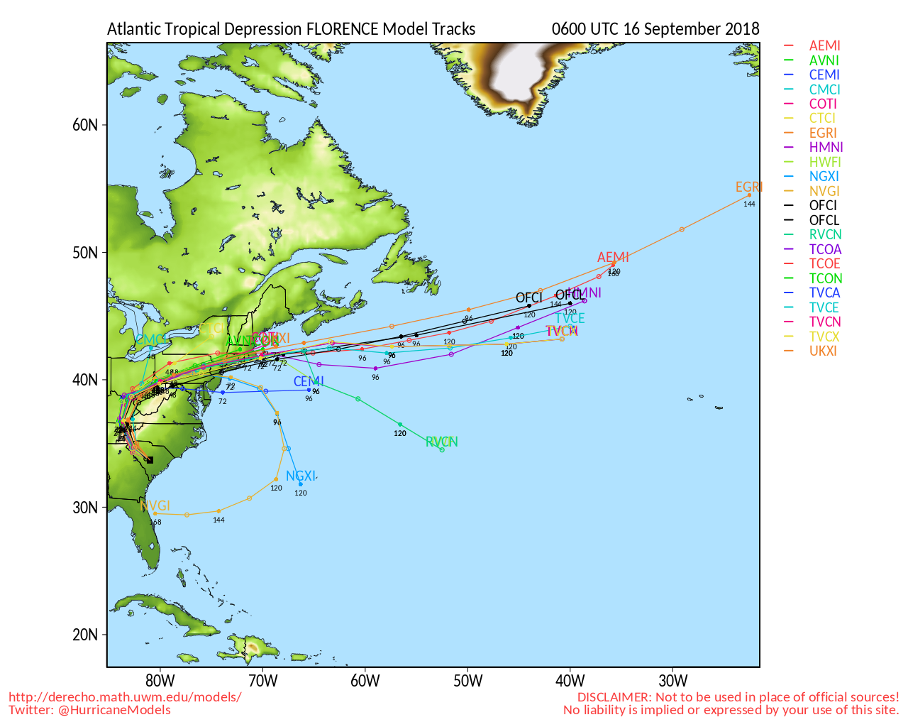
Clark Evans Track Model Plot of Florence
(Animated!) Model Plots in Google Earth - In Google Maps
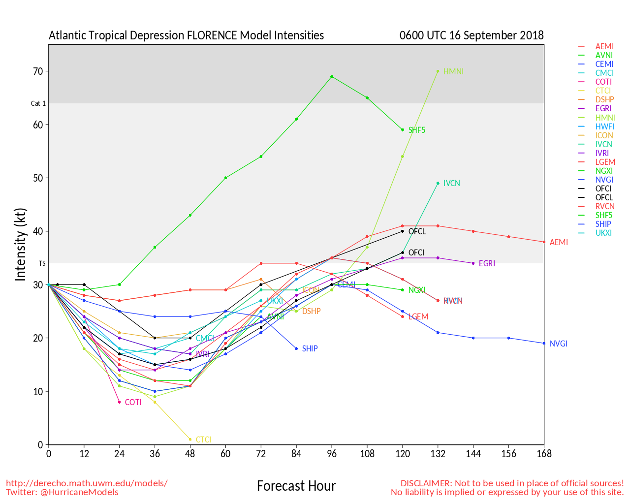
Clark Evans Intensity Model Plot of Florence (Animated!)
Clark Evans Track Plot of Florence
Other Model Charts from Clark
Clark Evans Top 10 Analog Storms for Florence
More model runs on from RAL/Jonathan Vigh's page
NRL Info on Florence -- RAMMB Info
COD Atlantic Satellite View
Isaac Event Related Links
SFWMD Model Plot (Animated Model Plot) SFWMD Hurricane Page
[https://flhurricane.com/floatanimator.php?year=2018&storm=9 Flhurricane Satellite Floater Animation of Isaac
GOES Floater
Animated Model Plot of Isaac
Clark Evans Track Model Plot of Isaac
(Animated!) Model Plots in Google Earth - In Google Maps
Clark Evans Intensity Model Plot of Isaac (Animated!)
Clark Evans Track Plot of Isaac
Other Model Charts from Clark
Clark Evans Top 10 Analog Storms for Isaac
More model runs on from RAL/Jonathan Vigh's page
NRL Info on Isaac -- RAMMB Info
COD Atlantic Satellite View
Helene Event Related Links
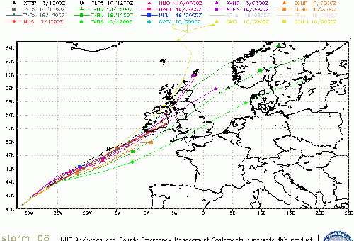
SFWMD Model Plot (Animated Model Plot) SFWMD Hurricane Page
[https://flhurricane.com/floatanimator.php?year=2018&storm=8 Flhurricane Satellite Floater Animation of Helene
GOES Floater
Animated Model Plot of Helene
Clark Evans Track Model Plot of Helene
(Animated!) Model Plots in Google Earth - In Google Maps
Clark Evans Intensity Model Plot of Helene (Animated!)
Clark Evans Track Plot of Helene
Other Model Charts from Clark
Clark Evans Top 10 Analog Storms for Helene
More model runs on from RAL/Jonathan Vigh's page
NRL Info on Helene -- RAMMB Info
COD Atlantic Satellite View
95L Event Related Links
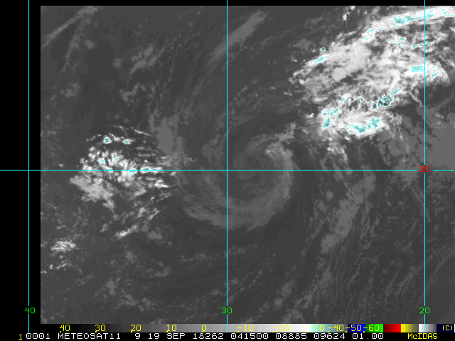
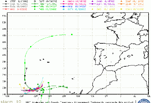
SFWMD Model Plot (Animated Model Plot) SFWMD Hurricane Page
[https://flhurricane.com/floatanimator.php?year=2018&storm=10 Flhurricane Satellite Floater Animation of 95L
GOES Floater
Animated Model Plot of 95L
Clark Evans Track Model Plot of 95L
(Animated!) Model Plots in Google Earth - In Google Maps
Clark Evans Intensity Model Plot of 95L (Animated!)
Clark Evans Track Plot of 95L
Other Model Charts from Clark
Clark Evans Top 10 Analog Storms for 95L
More model runs on from RAL/Jonathan Vigh's page
NRL Info on 95L -- RAMMB Info
COD Atlantic Satellite View
96L Event Related Links
SFWMD Model Plot (Animated Model Plot) SFWMD Hurricane Page
[https://flhurricane.com/floatanimator.php?year=2018&storm=11 Flhurricane Satellite Floater Animation of 96L
GOES Floater
Animated Model Plot of 96L
Clark Evans Track Model Plot of 96L
(Animated!) Model Plots in Google Earth - In Google Maps
Clark Evans Intensity Model Plot of 96L (Animated!)
Clark Evans Track Plot of 96L
Other Model Charts from Clark
Clark Evans Top 10 Analog Storms for 96L
More model runs on from RAL/Jonathan Vigh's page
NRL Info on 96L -- RAMMB Info
COD Atlantic Satellite View
For Florence:
Mid-Atlantic/Carolina Links
Southeast Composite Radar Loop
(Latest Static)
Charleston, SC Radar Radar Loop
(Latest Static)
Wilmington, NC Radar Radar Loop
(Latest Static)
Morehead City, NC Radar Radar Loop
(Latest Static)
Norfolk/Wakefield, VA Radar Radar Loop
(Latest Static)
Area Forecast Discussions:
Charleston, SC -
Wilmington, NC -
Morehead City, NC -
Norfolk/Virginia Beach/Hampton Roads, VA
Power Outage Maps:
South Carolina Power Outage Map
North Carolina Power Outage Map
Virginia Power Outage Map
Coastal South Carolina Media:
Myrtle Beach Sun News
Charleston Post and Courier
94.3 WSC Charleston News Radio
Power Outage Map: South Carolina Power Outage Map
Eastern NC/OBX/Hampton Roads Media:
North Carolina Power Outage Map
North Carolina Flood Inundation and Mapping Network
Star News Online (Wilmington)
Outer Banks Sentinel
Hampton Roads Pilot
WWAY TV 3 Wilmington, NC (ABC)
WECT TV 6 Wilmington, NC (NBC)
Fox Wilmington (FOX)
WILM TV 10 Wilmington, NC (CBS)
WITN 7 - Eastern North Carolina TV (NBC)
WCTI 12 - Eastern North Carolina (ABC)
WNCT TV 9 - Eastern North Carolina (CBS)
Wavy 10 (NBC) - Hampton Roads/VA Beach, VA TV
WTKR 3 (CBS) - Hampton Roads/VA Beach, VA
WVEC 13 (ABC) - Hampton Roads/VA Beach, VA
NCDOT Travel info map, closures, etc
For Isaac:
StormCarib Reports from the Caribbean Islands
Caribbean Weather Observations
Barbados Brohav Weather Fax
Full Caribbean Radar Composite
Caribbean Broadcast Corporation (TV/Radio from Antilles)
San Juan, PR NWS Page
Various Caribbean Radio Stations
DR1 Dominican Republic Hurricanes
Edited by cieldumort (Mon Sep 10 2018 11:15 PM)
|
MikeC
Admin
Reged: Sun
Posts: 4543
Loc: Orlando, FL
|
|
The first scheduled recon flight for Florence is on Monday.
|
MikeC
Admin
Reged: Sun
Posts: 4543
Loc: Orlando, FL
|
|
94L Is now being tracked near Bermuda.
|
MikeC
Admin
Reged: Sun
Posts: 4543
Loc: Orlando, FL
|
|
Multiple National Weather Services local office in the southeast will start special upper air soundings at 2pm tomorrow to help with Florence forecasts.
|
MikeC
Admin
Reged: Sun
Posts: 4543
Loc: Orlando, FL
|
|
The official 11PM position for Florence is 24.8N, while the estimate is more 24.5N, which looking at the satellite it seems closer to 24.4 or 24.5, although without visible its hard to say. The NOAA p3 flew out to Bermuda today, so it should be able to get up into the air in the morning to sample the air around the system. The actual hurricane hunter aircraft won't be able to fly into it until Monday.
|
MikeC
Admin
Reged: Sun
Posts: 4543
Loc: Orlando, FL
|
|
The NOAA P4, found a 990mb reading Florence, so it may be a bit stronger than the 11AM Advisory. They do discuss the potential for rapid intensification to exist, however..
|
cieldumort
Moderator
Reged: Mon
Posts: 2305
Loc: Austin, Tx
|
|
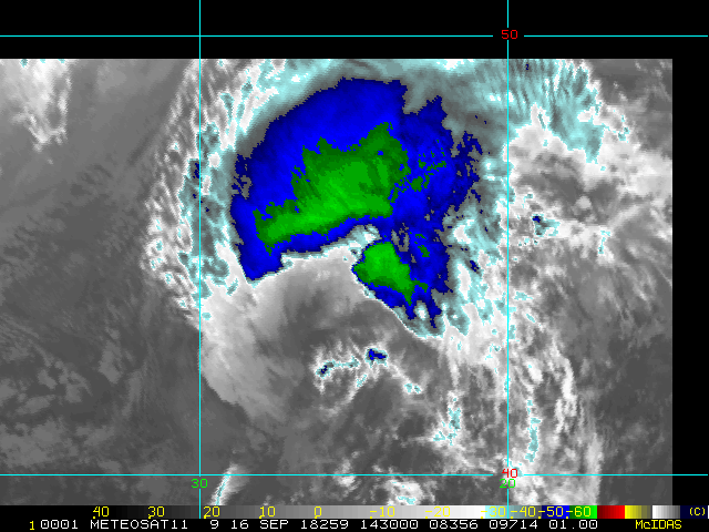
The non-tasked recon mission through Florence today has just finished, finding Florence a deepening tropical cyclone with winds well into upper-end Trop Storm/H1 at flight level, and clean SFMR readings of about 50-60 KTS at the surface. Florence is likely to become a hurricane again at any time now. In fact, recent analysis from SSD is already there.

|
MikeC
Admin
Reged: Sun
Posts: 4543
Loc: Orlando, FL
|
|
TD#9 Should become Issac at 5PM.
|
MikeC
Admin
Reged: Sun
Posts: 4543
Loc: Orlando, FL
|
|
Best track signals that Florence may be upgraded back to hurricane at the 11AM Advisory.
|
MikeC
Admin
Reged: Sun
Posts: 4543
Loc: Orlando, FL
|
|
94L has been dropped from being tracked. The w. Carib system will likely become 95L soon, however.
|
cieldumort
Moderator
Reged: Mon
Posts: 2305
Loc: Austin, Tx
|
|
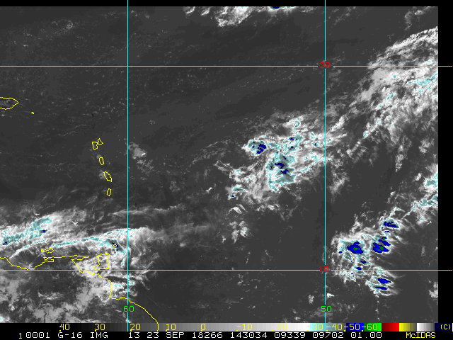
Image below (cr. Weathernerds.org) did a great job capturing all the current systems in the Atlantic today,
combining Visible Satellite, Global Lightning Mapper and ASCAT scatterometer wind data. Stunning.

|
cieldumort
Moderator
Reged: Mon
Posts: 2305
Loc: Austin, Tx
|
|
Dr. Klotzbach: Quote:
The Atlantic now has 3 hurricanes at the same time: #Florence, #Helene and #Isaac. This is the 11th year on record that the Atlantic has had 3+ hurricanes simultaneously. Other years were 1893, 1926, 1950, 1961, 1967, 1980, 1995, 1998, 2010, and 2017.
|
MikeC
Admin
Reged: Sun
Posts: 4543
Loc: Orlando, FL
|
|
Florence is rapidly looking better on satellite this morning, it's more than likely it'll be a major hurricane at the 11AM advisory. The Air force recon team arrives in it later today.
|
MikeC
Admin
Reged: Sun
Posts: 4543
Loc: Orlando, FL
|
|
Evacuation orders up for Dare County in the outer banks.

|
MikeC
Admin
Reged: Sun
Posts: 4543
Loc: Orlando, FL
|
|
Recon recently found a pressure of 956mb and a flight level wind of 135 mph.
|
cieldumort
Moderator
Reged: Mon
Posts: 2305
Loc: Austin, Tx
|
|
Dr. Klotzbach Quote:
#Florence is now a Category 4 hurricane. It has intensified by 40 mph in the past 13 hours. The last Atlantic hurricane to intensify as rapidly as far north as Florence's current location is Hurricane Humberto (2007).
|
MikeC
Admin
Reged: Sun
Posts: 4543
Loc: Orlando, FL
|
|
South Carolina Governor Henry McMaster orders the evacuation of all hurricane evacuation zones in all coastal counties, beginning at noon tomorrow Tuesday, September 11, 2018
https://scemd.org/prepare/know-your-zone/
More information below:
https://www.postandcourier.com/news/evac...0c881683a8.html
|
Prospero
Storm Tracker

Reged: Fri
Posts: 267
Loc: Gulfport, FL
|
|
It was one year ago today that we were sitting around with no electricity on what turned out to be a very nice evening outside after Irma came through. We fired up our grill and started to cook our quickly thawing meat from our freezer. The days leading up to it remind me of Florence heading towards North Carolina! In fact the morning of the 10th last year the prediction was for a Cat 3 to basically go up our street here in Gulfport by the end of the day. Whew! We were actually very scared. What would we do if we lost our home??
So we were lucky, as many in the current path of Florence will be. (Some will not be so lucky.) But even lucky means no power for days or weeks (two weeks for us last year), throwing out spoiled food, cleaning up debris, cutting trees that have been damaged, suffering with no A/C, nowhere to buy gas for your car, NO ice anywhere to be found, etc. We had a Laurel Oak that fell on our house that our favorite Tree Service Company removed on the 11th last year. Our roof was OK, but we miss the shade it provided over the years!
It is exciting to have a storm approach. Some of us watch the spaghetti plots and wish for it to be closer, BUT not close enough to knock our power! Sick indeed. Yet we all know the cost, suffering, inconvenience, and even loss of life is a serious consequence for these storms.
We know some are skeptical and being slow to prepare for Florence, but with a storm like this, even the outside areas will have to deal with a lot of results that can be costly and inconvenient, and dangerous.
Supplies will run out quickly in the next day or so, if you want to board up your windows, do it now. We paid high dollar at the last minute for cabinet quality wood to cover our windows as all the plywood was sold out by the time we decided to do it. Glad we did too! Even the expensive wood had dents and scrapes that prevented our glass windows from breaking!
Take action now.
--------------------
Gulfport Florida Webcam - Gulfport Florida Weather Station - Clearwater Beach Cams
|
kspkap
Weather Watcher
Reged: Sat
Posts: 35
|
|
Very good advice! Before the four 2004 hurricanes hit Florida (we lived in St. Cloud) we purchased plywood, cut to fit each window, drilled holes into the plywood and installed permanent talons along side each window. Each piece of plywood was marked for the window it fit. When it came time to board our windows we were prepared as we matched the holes to the talons then fastened with a wing nut. We stored the “hurricane plywood” in the garage where it was available if needed. All folks in hurricane prone states should prepare as we did before a storm is even thought about. Do it at your leisure in the off season....then a major part of preparation has already been done.
But sometimes plywood won’t save your home as evidenced by ’s storm surge in 2005. You can’t fight the force of water so evacuate if told to do so. We moved to Long Beach, MS several years after . The following photo shows what a high storm surge can do. The slab lot we bought had a 32 ft storm surge! Folks take heed...prepare....then if mandated....evacuate sooner than later. You more than likely would not survive the following:
https://en.m.wikipedia.org/wiki/Effects_...mississippi.jpg
--------------------
Donna-1960, Charley-2004, Frances-2004, Jeanne-2004, Issac-2012, Zeta-2020
|
Lamar-Plant City
Storm Tracker

Reged: Mon
Posts: 383
Loc: Plant City, Florida
|
|
You just described EXACTLY what we have at our house. My wife found pieces of 4 ft by 18 in plywood in 3/4" years ago that were leftovers from a nearby place that makes large pumps and has to box them in 3/4" plywood. 4 of them stacked one on top of the other will cover each of our front windows....it takes 3 for the side window. I labelled them, then drilled holes and placed anchors in the cement block. Takes my wife, daughter and I about 2 hours to pull the wood out, get it up and tighten it down with wingnuts. Have special boards I made for the slider in the back and a couple of smaller windows. My neighbors house is vacant but he cut 1/8 plywood boards that I can slip in between his window bars and screw into place in less than an hour. It really pays to have this ability. Mom has custom aluminum shutters that can be attached in a couple of hours. if you haven't yet...do it! whatever it takes so you are prepared for the inevitable...maybe not this year, but some year....
--------------------
If you don't like the weather, wait 5 minutes...
2023 Season Prediction: 17/6/2
|
 Threaded


