CFHC Talkback For News Story #123:
Newest Talkback: 04:47 PM 09-30 EDT

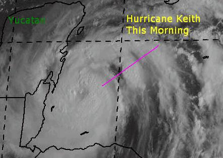
Keith Now Hurricane In Northwest Caribbean
11:02 AM EDT - 30 September 2000

Keith now has a very impressive looking eye.. 5PM updates forthcoming...

Keith has been upgraded to a Category 1 Hurricane with 80MPH Winds. It is expected to move slowly north northwest and cross the Northeast section of the Yucatan peninsula. Probably as a Category 2 system. Currently the NHC's calling its movement as meandering. I expect Keith to weaken a bit while its over land, but not below strong Tropical Storm strength, to reemerge in the Gulf of Mexico and reform into a Hurricane. Mexico has issued Hurricane Warnings now for the North coast of the Yucatan. Folks in the Gulf (Especially Florida, Alabama and Louisiana) will want to watch this one closely, as things could change. Keith is starting to look very good on satellite as well. So there is a chance it could deepen more rapidly than expected. Folks in the Yucatan will be advised to prepare now, if you haven't already.

A big caveat with the prediction of the North Northwest movement involves past history with
Hurricane Mitch [ Visible Sat of Mitch (1998)]. Models wanted to take that storm to the north, but it eventually meandered toward the west. Becoming a category 5 system and devistating that part of Central America. Mitch caused more deaths than any Atlantic storm previously. Therefore, the NNW solution is not the only solution. Mitch was further south than Keith at the time. But Belize needs to know about this possibility.

Joyce is moving more westward and will be in the southern winward islands tomorrow. I don't think it will regain hurricane strength when it arrives there. After that it's too soon to tell.

Keith!

Comments or Questions? Everyone is invited to use it. Use the comment button by the story Headline.


NRL Monterey Marine Meteorology Division Forecast Track of Active Systems (Good Forecast Track Graphic and Satellite Photos)
Map with nearly all model projected tracks plotted for Isaac., Joyce, or Keith From Michael Bryson.
Crown Weather Services Tropical Update (Includes Map with multiple forecast model tracks)
Snonut's Hurricane Reports
Other commentary at: Mike Anderson's East Coast Tropical Weather Center - Stormwarn2000 - SCOTTSVB's Hurricane Update Center - Jim Williams' Hurricane City - Gary Gray's Millennium Weather - Even More on our Links Page
Satellite images at: [Visible] (visible -- Daytime Only) [Infrared] (infrared), and [Water Vapor] (water vapor)
Loops: Visible Loop - Infrared Loop - Water Vapor Loop
NASA GHCC Interactive Satellite images at:
[NAtl visible] (visible -- Daytime Only) [NAtl infrared] (infrared), and [NAtl water vapor] (water vapor)--Nasa source.
Ocean Surface Winds Derived from the SeaWinds Scatterometer (Experimental)
StormCarib.com has reports from folks in the Caribbean islands themselves and is worth checking out when storms approach the Caribbean.
Ouragans.com Français -- L'information sur des ouragans comprenant beaucoup de liens.
Tormenta.net Español -- Gran información sobre huracanes aquí.
Live Webcam image from Florida Emergency Management's Emergency Operations Center
Florida Emergency Management Activation Page / Situation Updates

Some Forecast models: (NGM, AVN, MRF, ECMWF, ETA)
DoD weather models (NOGAPS, AVN, MRF)
AVN, ECMWF, GFDL, NOGAPS, UKMET

- [mac]


Show All Comments

Displaying Talkbacks #1 - #16 (of 16 total)

ya know... (#1)
Posted by: Frank Location: Tallahassee
Posted On 12:05PM 30-Sep-2000 with id (QRXNQXVNQRSNSW*)


keith's track so far.. i have to draw this parallel even though it isn't quite appropriate.. but keith reminds me of roxanne/95. i remember that initially everything brought roxanne north. living in south alabama and having to chainsaw up piles of debris left by opal (oh my evil dad made me feed it all to the chipper shredder!) i was watching roxie pretty closely.. but the storm turned west and crossed the yucatan after all. then it did about a week of stunts in the BOC. weve been fighting the signs storms are giving us this year.. persistent behavior, not climatology or model runs, have been the real indicators as to what theyre fixing to do. maybe we shouldnt be overlooking the persistent west motion keith has been exhibiting, much as persistently forecasting joyce to reintensify and turn northwest hasnt made anybody look good (tack me onto that list). im starting to think keith will cross the yucatan slowly nw, entering near chetumal and exiting around merida. regardless, i dont think keith will start turning northeast for a few days. maybe not at all, could go west or north. at most the shortwave (or is it a longwave?) crossing the southeast might make it go north instead of wnw. the upper air models ive looked at weaken the westerlies as time goes on.. until another shortwave comes by late in the week somebody earlier said a wobbler in the gulf.. thats a possibility too. all these down the road possibilities are all were thinking of, but the people who definitely have to deal with this storm are in the yucatan. they could have a cat 2 or 3 breathing down their necks in 12 hours.
heh.. looks like im the outlier in the cfhc minds model runs. my storm goes more west, and is weaker in the end.
have a good one, everybody. make me eat my words.

Newest T#'s for Keith as of 2pm (#2)
Posted by:
Colleen Location: Lakeland, Florida
Posted On 02:46PM 30-Sep-2000 with id (RPUNQXXNQYYNQWS*)


TPNT KGWC 301810

A. HURRICANE KEITH (FIFTEEN)

B. 30/1715Z (123)

C. 18.0N/9

D. 86.8W/2

E. ONE/GOES8

F. T4.5/4.5/D2.0 24HRS -30/1715Z-

G. IR/EIR/VIS/MSI


06A/ PBO 22NM RAGGED, CLOUD-FILLED EYE/ANMTN. EYE IS NOT VISIBLE IN IR IMAGERY/ANMTN. CNVCTN WRAPS 1.00 ON THE LOG10 SPIRAL. ADDED 0.5 TO DT FOR WHITE BAND. FINAL T IS BASED ON PT. MET YIELDS T4.0.

Still looking for new recon report, haven't seen one updated yet. I bet it is more than 80mph, though.


intensity (#3)
Posted by: jimmy Location: mobile,al
Posted On 02:54PM 30-Sep-2000 with id (RPTNYVNQTYNRQS*)


I agree Colleen. I would be surprised if Keith is not at 90-100mph already. It looks like this could be the big Hurricane that the north central gulf coast has escaped the past few years. What do you guys think.

Re Frank (#4)
Posted by: JJ
Posted On 03:01PM 30-Sep-2000 with id (RPUNQXXNQYRNQWT*)


I must agree with Frank's outlook on Keith, as I was thinking the same thing. Even the discussion invoked Mitch, another storm which was forecast to turn north and didn't. I think landfall will be in the Yucatan, either in Belize or near the Belize/Mexico border. Given its slow rate of motion, Keith could be over land for some time, and any turn to the north will be slow to develop. Even if it does turn north, that will only lengthen its stay over land, unless acceleration occurs. It may indeed not turn north until its over the water again. In any case, the U.S. has bought some time--this storm may mean little for the states.

Addendum (#5)
Posted by: JJ
Posted On 03:02PM 30-Sep-2000 with id (RPUNQXXNQYRNQWT*)


Also wouldn't be surprised if Keith is stronger than sat estimates indicate. Perhaps much more so.

Recon (#6)
Posted by: Robert T.
Posted On 03:08PM 30-Sep-2000 with id (QYYNRRWNRPNQVR*)


reports from the recon right now is 977 millibars and 60knts and 82 knts flight winds with complete eye wall i bet they find stronger winds

On another note i have noticed in the past few weeks another Robert has started posting and i have been posting here scince 98 so to avoid confusion ill add my middle inital to the end of my name when i post.

Latest Recon Flight KEITH (#7)
Posted by: Mark Ruck Location: Ft Myers Florida
Posted On 03:13PM 30-Sep-2000 with id (QRNWWNQSTNXP*)


VORTEX DATA MESSAGE
A. 30/1808Z
B. 17 DEG 55 MIN N
86 DEG 40 MIN W
C. 850 MB 1223 M
D. 60 KT
E. 013 DEG 23 NM
F. 096 DEG 82 KT
G. 011 DEG 15 NM
H. EXTRAP 977 MB
I. 17 C/ 1556 M
J. 21 C/ 1526 M
K. 18 C/ NA
L. CLOSED
M. C40
N. 12345/8
O. 0.1/2 NM
P. AF966 0415A KEITH OB 09
MAX FL WIND 82 KT N QUAD 1803Z. SLP EXTRAP FROM 850MB. EYEWALL
COMPLETE, BUT VERY THIN S THRU SW.


where will he go????? (#8)
Posted by: cd
Posted On 03:14PM 30-Sep-2000 with id (VTNQRNQPUNQVW*)


ok we know we have a strong storm now where does he go

KEITH (#9)
Posted by: Mark Ruck Location: Ft Myers Florida
Posted On 03:31PM 30-Sep-2000 with id (QRNWWNQSTNXP*)


Hello All,
I've been holding back forcasting Keith because I felt even though it moved w-nw over the last several hours I was not convinced this was a definit direction or just a repositioning and rapid development and now it sits again actually a movement a little southeastward which I believe is just a center wobble and its really stationary. But where will it go? I do agree Keith will move n-nw over the next 6-12 hours or even remain stationary but after the next 12 hours I see a more north track into the Gulf. This should take place over the next 24 hours. After that I'm up for opinions. There is really no strong feature from what I can see that will steer Keith but alot of smaller ones which is going to make Keith a nervious storm for forcasters. My best GUESS is Keith will become stationary in the Southeast Gulf again until something more influnces the system down the road. I need some input please!!!!

Question (#10)
Posted by:
Colleen Location: Lakeland, Florida
Posted On 03:33PM 30-Sep-2000 with id (RPUNQXXNQYYNQUQ*)


Ok, I have a question...do they base the winds on the 60knt level or the 82knt flight levels? or are they just not all the way in yet? Thanks!!

Where will he go??? (#11)
Posted by:
LONNY Location: HOLLYWOOD,FL
Posted On 03:38PM 30-Sep-2000 with id (QURNQVSNRPTNRQ*)


The question of the day.Where will he go? If he heads over land soon (mexico) he will most likely have a slow death at the rate he is moving. There are so many scenarios that I don't have a clue. The rememberance of Mitch, I am sure is on everyone's mind.Even though it is farther North than Mitch was. The question is when will the trough come and where will he be?

Will he move NE? (#12)
Posted by: Don Location: Miami
Posted On 04:09PM 30-Sep-2000 with id (QYYNRRWNSWNQXR*)


I remember small but very wet Hurricane Irene from last October; it came over Western Cuba and made a hard right, even though the models had it hitting north of Tampa. We never even had a watch or warning posted, even though the "eye" passed over western Miami-Dade County. Any thoughts of an eventual NNE motion? No storm this year has really done what it was "supposed to do."

Strengthening/Keith/Joyce (#13)
Posted by: Tom
Posted On 04:28PM 30-Sep-2000 with id (QSRNRRXNWPNQX*)


By far I am no expert, but looking at the IR and Visible for the last few hours, it looks like significant strengthening has occurred. I have seen enough of these to figure that this could already be at 115 or higher. It also looks like that Joyce is trying to make some kind of a come back. I was thinking, that with the movement of Joyce (if it survives) and the lack of movement of Keith, what could happen say by Tuesday/Wednesday!!
Any thoughts

NNE (#14)
Posted by:
Jim F. (http://flhurricane.com/jfaul/) Location: Ft. Lauderdale
Posted On 04:44PM 30-Sep-2000 with id (RPXNVQNQQUNRTY*)


NNE is a real possibility with a weakness developing in 36-48h. There are westerlies at 21-22N right now. Once it moves the models will do better and start picking up this weakness.

Damn he is getting strong (#15)
Posted by: Robert T.
Posted On 04:45PM 30-Sep-2000 with id (QYYNRRWNRPNQVR*)


if she stays over water he could be the next Mitch if he plays his cards right

I meant he not she (#16)
Posted by: Robert T.
Posted On 04:47PM 30-Sep-2000 with id (QYYNRRWNRPNQVR*)


Show All Comments


Return to Central Florida Hurricane Center Main Page