CFHC Talkback For News Story #145:
Newest Talkback: 12:39 PM 10-27 EDT

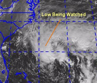
Low Area Heading Toward US
02:00 PM EDT - 26 October 2000

There is a low pressure system moving generally toward the west or westnorthwest north of the Bahamas approaching the US. It will probably head more north and northeastward later on before it gets too close, however. Right now it can be considered a non-tropical low system. Hurricane Hunter aircraft are on the way to check it out, needless to say it could bring nasty weather to the east coast of the US or Canada in the form of tropical or non-tropical storm. In fact, a non-tropical system has a much larger windfield (although normally nowhere near as strong as a hurricane). It could convert itself into a subtropical or tropical system, so we will be closely watching it.

Tropical, Subtropical, Non-Tropical... place your bets.

Comments or Questions? Everyone is invited to use it. Use the comment button by the story Headline.


NRL Monterey Marine Meteorology Division Forecast Track of Active Systems (Good Forecast Track Graphic and Satellite Photos)
Map with nearly all model projected tracks plotted for Nadine. From Michael Bryson.
Crown Weather Services Tropical Update (Includes Map with multiple forecast model tracks)
Snonut's Hurricane Reports
Other commentary at: Mike Anderson's East Coast Tropical Weather Center - Stormwarn2000 - SCOTTSVB's Hurricane Update Center - Jim Williams' Hurricane City - Gary Gray's Millennium Weather - Even More on our Links Page
Satellite images at: [Visible] (visible -- Daytime Only) [Infrared] (infrared), and [Water Vapor] (water vapor)
Loops: Visible Loop - Infrared Loop - Water Vapor Loop
NASA GHCC Interactive Satellite images at:
[NAtl visible] (visible -- Daytime Only) [NAtl infrared] (infrared), and [NAtl water vapor] (water vapor)--Nasa source.
Defiant Visible Infrared More...
Ocean Surface Winds Derived from the SeaWinds Scatterometer (Experimental)
Tormenta.net Español -- Gran información sobre huracanes aquí.

Some Forecast models: (NGM, AVN, MRF, ECMWF, ETA)
DoD weather models (NOGAPS, AVN, MRF)
AVN, ECMWF, GFDL, NOGAPS, UKMET

- [mac]


Show All Comments

Displaying Talkbacks #1 - #8 (of 8 total)

direction (#1)
Posted by: scottsvb (
http://communities.msn.com/HURRICANEUPDATECENTER)
Posted On 03:27PM 26-Oct-2000 with id (VSNSYNSVNYX*)


Uh,,i hope more people come back to this site,,
and post. Mike,,I feel this will go N and NNE and
bring maybe heavy snow and heavy rain to Maine or
\Newfoundland. I cant see any evidence of a w
or wnw movement. Reply if you find time\\


scott

System (#2)
Posted by:
Mike C. [CFHC] (http://flhurricane.com) Location: Newport News, VA (Currently)
Posted On 03:48PM 26-Oct-2000 with id (RPVNRTVNRRPNRUP*)


I wasn't clear on that, you are right. I changed the main article to be more clear on those points. I wasn't calling for "landfall" in the Us, more of just the possibility that it could see some effects if the wind field expanded.

MULTIPLE CENTERS (#3)
Posted by: Bill Location: Miami
Posted On 03:59PM 26-Oct-2000 with id (RPYNSNQURNSU*)


If you check out the latest GOES you can see three centers, but appears the main one is south of the main convection, and is moving somewhat w of north, don't know what the NHC will do with it...based on recon it is definitely a s/t storm, not sure it is organized enough yet to be a ts.
IHS,

Bill

Warm Core tropical cyclone (#4)
Posted by: Bill Location: Miami
Posted On 05:13PM 26-Oct-2000 with id (RPYNSNQURNSU*)


According to this we have a warm core tropical cyclone...no advisory from TPC yet...
URNT12 KNHC 261933
VORTEX DATA MESSAGE
A. 26/1933Z
B. 28 DEG 42 MIN N
72 DEG 21 MIN W
C. NA
D. 35 KT
E. 063 DEG 40 NM
F. 090 DEG 37 KT
G. 011 DEG 20 NM
H. EXTRAP 1000 MB
I. 20 C/ 321 M
J. 23 C/ 288 M
K. 19 C/ NA
L. NA
M. NA
N. 1234 /01
O. .5/10 NM
P. AF963 01XXA INVEST OB 14
MAX FL WIND 37 KT N QUAD 1905Z. SLP EXTRAP FROM 1500FT

IHS,

Bill

want a crash course here.. (#5)
Posted by: HankFrank Location: Tallytown
Posted On 07:34PM 26-Oct-2000 with id (QRXNQXVNQRSNSW*)


hey bill, you probably know more about this stuff than me.. could you explain why you think this system is tropical? im not sure what makes the difference.. as for it being warm core, yeah, i guess 20c is warm for flight level (850mb?), but does this alone make the storm tropical?.. and aside from the convection being really lopsided, why arent they calling the thing oscar now? really this question is from a met. undergrad to anybody out there who can explain this to me...
somebody please inform. also, how close do yall think 95L (they WERE calling it 98L) is coming to the nc outer banks? im guessing close enough to kick the winds up to gale force at hatteras. its been edging to the left of north today..

Reply (#6)
Posted by: JJ
Posted On 07:59PM 26-Oct-2000 with id (QRYNQQUNUSNQPS*)


I think what's really holding them back from starting warnings is the lack of convection over the center, its asymmetry, and the poorly-defined low-level center, with apparent multiple centers.
If convection were to fire up over and wrap around the center, I'm sure it would be upgraded.

consistency/digression (#7)
Posted by: HankFrank Location: Tallytown
Posted On 05:41AM 27-Oct-2000 with id (QRXNQXVNQRSNSW*)


i just keep thinking of leslie, and how they couldnt find flight level winds to gale force half the time, how the convection was always east of the center like a frontal band.. it was just a low cloud swirl other than that. does anybody notice the discrepancy? multiple centers, well, leslie did have a nice clean cut little vortex, but.. BERYL. doesnt matter. for our storm center... recon arrives at 8am eastern, so by late morning we should have another vortex message to debate. the new outlook just came across.. still just a 'non-tropical low'. with a flight level temp at 70F, a central pressure around 997mb, and 60 mph winds.. just a typical cold core system. yup.
well, enough of this fuzzy science. yall take it easy. gotta go take some more tangos down.
i never say it, its a sort of unspoken no-brainer, but great site. that goes to the guys who run it and the folks who post. ive learned a lot, especially from listening to you veteran storm watchers; and i appreciate your insights and advice.
muchas gracias.

Tropics (#8)
Posted by: Steve H.
Posted On 12:39PM 27-Oct-2000 with id (QSRNRRXNWPNQX*)


Outside of the low in the Western Atlantic, seems like things are pretty quiet in the Tropics. Looks like the "surface" circulation that was at 30N/71+W is rotating around a broader area of low pressure. Cloud tops don't look all that cold right now, so Oscar doesn't seem likely at this point. Only other area of casual interest is in the SW Caribbean; actually it's really south of Panama in the East Pacific. Models a couple of days ago were developing this system, but backed off, mainly due to the predicted hostile upper level environment. The MRF still shows a weak low coming into the SW Caribbean, then struggling. There is some deep convection south of Panama that is associated with a weak low which, if it crosses Panama, may have some potential to develop. Upper Level winds are not terribly hostile right now, and may actually relax over the next few days. Anyhow, it will be interesting to see if the models show this feature developing again. Anyway, i'm bored, it's lunchtime, and there's not much else to write about now, 'cept those damn Yankees! Cheers!!


Show All Comments


Return to Central Florida Hurricane Center Main Page