CFHC Talkback For News Story #69:
Newest Talkback: 12:15 PM 08-23 EDT

Models Back Toward the West
06:48 AM EDT - 23 August 2000

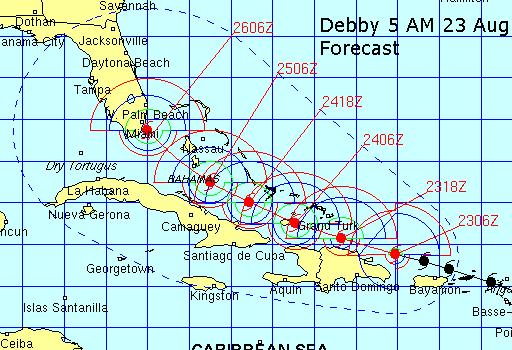
This morning the South Florida / Gulf Scenarios chances just went up. It a rather drastic change from yesterday, almost all of the models now take the Storm westward into the Gulf of Mexico. However, these seem extreme (and already a bit off), so that leaves the middle ground, which could include South Florida and the Keys.

There are a few possibilties:

From one extreme to the other:

1. It does go into the gulf. (Not Out of the Question)
2. It travels into the Florida Keys. (I expect some voluntary Evacucations happening here today or tomorrow).
3. It could hit South Florida around Miami.
4. It could enter north of Miami... Basically the worst thing imaginable for Emergency management (and the Insurance Industry). There is a fair chance that Debby could enter and travel up through the state of Florida as a major hurricane.
5. It could skirt the East coast of Florida ala David 1979 and eventually landfall somewhere north of Florida.
6. A miracle could happen and turn it out to sea.

The most likely answer lies somewhere in the middle of those. Speculation is rampant now, and I'm sure that it will cause a lot more headaches as time passes. Indeed the 5AM official forecast from the National Hurricane Center has numbers 3 and 4 as real possibilites.

Therefore, keep watch and take any advice local authorities give you. Don't take our word for it, listen to the pros at the NHC. And pepare. And don't panic nor let hype consume you -- stay informed.

Please leave a comment if you hear something from local media, government, etc. on Evacuations, General Storm Information, or all around good tips. Thanks. Today and early tomorrow will be decision day for a lot of people. Friday will start to be action day (timelines could change, plan for this too). And as Jim William's said last night, remember that sometimes friends and family can wind up being more of a hurricane themselves.

Debby 5AM Forecast Track
We are tentively scheduling a chat at 7PM tonight lasting for as long as we feel the need. Jim Williams at
Hurricane City will be doing another live broadcast at 8PM. We bumped it up an hour because you may need to watch Survivor to get some tips for the weekend. Monday didn't mix well with some because of Football. (Although a pic in pic window with TWC on and the game on works).

Comments or Questions? Everyone is invited to use it. Use the comment button by the story Headline.

NRL Monterey Marine Meteorology Division Forecast Track of Debby (Good Forecast Track Graphic)

StormCarib.com has reports from folks in the Caribbean islands themselves and is worth checking out when storms approach the Caribbean.
Ouragans.com Français -- L'information sur des ouragans comprenant beaucoup de liens.
Tormenta.net Español -- Gran información sobre huracanes aquí.

Crown Weather Services Tropical Update (Includes Map with multiple forecast model tracks)
Snonut's Hurricane Reports
Weathervine Storm Intercept Team's Audio and Video broadcasts
Live Webcam image from Florida Emergency Management's Emergency Operations Center
Florida Emergency Management Activation Page / Situation Updates
Nice Satellite Image of Atlantic (IR Colorized)

Satellite images at: [N.A. visible] (visible -- Daytime Only) [N.A. infrared] (infrared), and [N.A. water vapor] (water vapor)--Nasa source.

Some Forecast models: (NGM, AVN, MRF, ECMWF, ETA)
DoD weather models (NOGAPS, AVN, MRF)
AVN, ECMWF, GFDL, NOGAPS, UKMET

- [mac]


Show All Comments

Displaying Talkbacks #1 - #13 (of 13 total)

This Far Out (#1)
Posted by:
Jim F. (http://flhurricane.com/jfaul/) Location: Ft. Lauderdale
Posted On 07:43AM 23-Aug-2000 with id (RPXNVQNQQRNSX*)


It appears Miami has a bullseye on it right now. When was the last time a 72 hour forecast position was hit right on the nose? Probably never. Bottom line is this appears to be a keys/south florida event in 72 hours. The wobbles on Friday/Saturday will make all the difference as to who gets the core and who gets the tropical storm force winds. Keep this in mind..at this time, most of the action is on the north side of the circulation center, this would change if and when it vertically stacks and becomes symetrical. If it "stacks" the northeast quadrant is usually the most intense. Therefore, landfall just south of Miami of a westwartd moving system is not good as stated in Mike's headline story above. Wobbles will make all the difference..Georges was projected to come into South Dade 12 hours before landfall and it wobbled south and we hardly had anything in Fort Lauderdale.

They didnt know where georges was (#2)
Posted by: Robert
Posted On 07:51AM 23-Aug-2000 with id (RPWNSVNRQRNYT*)


They also didnt know what georges was doing it was over cuba. Cuba does not show its radar and know recons are allowed over it so it was all satelite

Westward Track (#3)
Posted by:
Mike C. (http://flhurricane.com) Location: Newport News, VA (Currently)
Posted On 08:03AM 23-Aug-2000 with id (RTNRNUSNVY*)


Jim is right, I didn't want to downplay the move west scenario. It would be very damaging like Jim said. Especially if the NE Quadrant went near Miami. However, this would be relatively small compared to a turn up the coast with the NE Quad of the storm riding up I95. Either way it's bad news.

The above was speculation. It's too early to tell really. Plan for the worst and hope for the best.


One word.... (#4)
Posted by: Jim Mogle Location: Kissimmee, Fl
Posted On 08:12AM 23-Aug-2000 with id (RPUNRTRNRRXNSQ*)


Crapshoot! Until the storm gets some better organization, I think the models are going to have a tough go of it. Personally, I am a bit leery of a west to Texas track. I'm just not too sure that the initializing data was all that good. I think some of the models were fooled by the dropsonde readings into thinking the storm was moving faster. Otherwise, I feel all of the other possible paths are in play. It may be another 12-24 hours before a reasonable model agreement from one period to another occurs.

8:00am Advisory (#5)
Posted by:
Colleen Location: Lakeland, Florida
Posted On 08:45AM 23-Aug-2000 with id (QURNQVSNQYUNRQT*)


the 8:00am advisory talks more of a wnw track as the ridge weakens....which sounds like bad news to me. It's Wednesday, would not be surprised to see watches/warning issued today at some point. As for the models, we have to remember that all the information is put into a computer and it spits it's forecast out...so, say someone makes a mistake/ vavoom you have a bad model forecast. It's going to impact us one way or the other...Just be prepared....Colleen

I believe (#6)
Posted by: Noel
Posted On 09:05AM 23-Aug-2000 with id (QURNQVSNRPVNRPR*)


Miami/Keys is the target and from New Orleans eastward is the GOM target like it was for Georges, not Texas.

The Keys - On the Move (#7)
Posted by: Cathy Location: Bartow, FL
Posted On 10:19AM 23-Aug-2000 with id (TNRQNQYVNYW*)


I just got word that non-residents are being asked to leave and the Military will begin evacuations at 2pm.

debby is weaker then ever (#8)
Posted by: scottsvb (
http://communities.msn.com/HURRICANEUPDATECENTER)
Posted On 10:24AM 23-Aug-2000 with id (VSNRSNQXWNWU*)


First of let me say that Debbie's track has been Very easy to frocast,,,,,I've hads little trouble in forcasting the direction of Debbie over the last 5 days and also most of her strength,,but I didn't expect this much of a pressure wise...everyone can go back and look at my past post to see what all I've been saying from the weak south side of Debbys winds to where she would mve through the NE carr and skim north of Puerto Rico and be just NE of Cuba on Thurs morning.
Now what is surprising is the PRessure..1005mb as of this post,,,that usually cordinates as a weak tropical storm,,nowhere close to being a hurricane. Winds are clsoe to 50mph,though i don't think the NHC will lower them that much,but should be downgraded at 11am.
The sheer is not the problem folks now,,its how close she is to land...the southerly inflow into the system is being cut off and will until she moves away from Hispaniola. Cause of the weakening she has moved west and the trough to her NE is by her.
Now her future I still keep the same as she will intensify tongiht and through the 72 hour period. She should be a hurricane later tonight again and be near the Keys to Miami area by later Friday night. A wnw and NW turn should take her eighter up the Fl state or up near the W side of fl and into the coast. I still see her as a major Hurricane on Friday. Note now there is a small chance sh ecould move more West still and interact with Cuba and keep her weaker longer and that would keep her form being a major hurricane when she reaches Fl.
Also to Note: I love to follow only the AVN and Nogaps models which the Nogaps has been very good in the direction of a TS. It has been saying the Gulf for 2 days now,,,and its a good bet she might,,,now alot of models are saying,,no eastern US but just eastern Fl or into the gulf themselvse.
More will be updated this evening/// scottsvb

T.S. Debby (#9)
Posted by: Brian Location: Hollywood, Florida
Posted On 10:29AM 23-Aug-2000 with id (QSWNURNRPPNQTX*)


Yes, I'm sure we'll see Billy Wagner speaking on local media during the 11 am news and advisory updates here in South Florida. It appears that Debbie is undergoing some extensive shear from the SSW. Thus, the system appears to be attempting to remain intact. I would not be surprised if Debby was reduced to a 70mph T.S. at 11 am. But we both know that would be a public policy disaster for the NHC because chances are, the bottom will fall out on the system beginning tonight. Thereby creating a false sense of security for S. Fla. residents. Navy tracking puts the system inland on the Dade-Broward line on Sat morning. Also there may be SIGNIFICANT strengthening, possibly up to a 3 or 4 prior to landfall. Moving over the Bahamas, I believe anything is possible, ala the Keys storm of '35, which formed into a (5) in a mere two days!

spelling (#10)
Posted by: scottsvb (
http://communities.msn.com/HURRICANEUPDATECENTER)
Posted On 10:29AM 23-Aug-2000 with id (VSNRSNQXWNWU*)


sorry about the spelling people,,,I type really fast and am always in a hurry,,,sorry if it affends anyone,,,thanks scott

a quick model note, (#11)
Posted by: scottsvb (
http://communities.msn.com/HURRICANEUPDATECENTER)
Posted On 10:44AM 23-Aug-2000 with id (VSNRSNQXWNWU*)


Like I said earlier,,the models say almost forget about the east coast of the US thing,,but not east fl.
But all the main models show a move just n of the eastern tip of Cuba,,,,hmmm all are very close agreement with the others so,,this might happen even alittle more south than what i said,,they are apperently picking up on her weakness''but still a turn up the w side of florida is expected and to strengthen. They haven't posted the 11 am advisory folks,,but I garrentee you folks she will be just a strong TS at that advisory and not be a hurricane,,or if I'm wrong,,then ignore my posts....hehe ok scottsvb

Good Post Scott (#12)
Posted by:
Colleen Location: Lakeland, Florida
Posted On 11:50AM 23-Aug-2000 with id (RPUNQXXNQYRNQWT*)


Good post Scott, and you are right, she was downgraded...because of her proximity to land. Watches/warnings (per Max Mayfield on CNN this morning) will be issued at either 5pm or 11pm. They should be issued from the east coast over to the west coast, because they believe she will cross out of the s/central part of the Gulf Coast or the central part of the Gulf Coast...I don't believe they are leaning towards a move to the Gulf either. Colleen

It Looks more and more (#13)
Posted by: Pensacolian
Posted On 12:15PM 23-Aug-2000 with id (RPUNQXXNQYWNQWS*)


Like a Gulf Storm. I don't like it!


Show All Comments


Return to Central Florida Hurricane Center Main Page