CFHC Talkback For News Story #83:
Newest Talkback: 11:04 PM 09-06 EDT

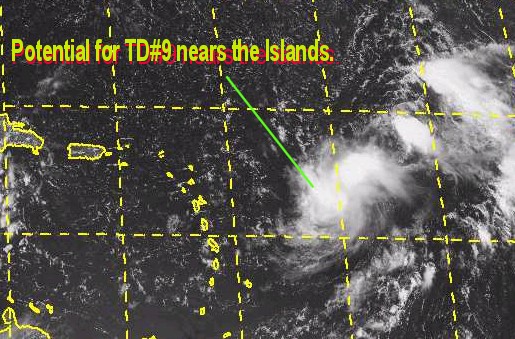
Another Heads up for the Caribbean
12:41 PM EDT - 06 September 2000

At 5PM. it wasn't upgraded, and it still may not be. Here's the updated chance bit:

(forget it) 0 1 2 3 4 5 6 7 8 9 10 (sure thing)
           [--------------*-------]


A potential new tropical depression or storm is now east of the northern Leeward islands and is approaching that way.

Folks in these islands will need to watch it as it is looking very impressive this afternoon. It probably will be upgraded today. An aircraft recon flight is heading toward it today also.

We'll keep watch. There also is a system in the Gulf that has some potential, but needs to persist a bit more.
My Development Chances Scale for this wave: (East of Leewards)
(forget it) 0 1 2 3 4 5 6 7 8 9 10 (sure thing)
           [-----------------*----]
TD#9 is warming up

Comments or Questions? Everyone is invited to use it. Use the comment button by the story Headline.

NRL Monterey Marine Meteorology Division Forecast Track of Active Systems (Good Forecast Track Graphic and Satellite Photos)

StormCarib.com has reports from folks in the Caribbean islands themselves and is worth checking out when storms approach the Caribbean.
Ouragans.com Français -- L'information sur des ouragans comprenant beaucoup de liens.
Tormenta.net Español -- Gran información sobre huracanes aquí.

Crown Weather Services Tropical Update (Includes Map with multiple forecast model tracks)
Snonut's Hurricane Reports

Satellite images at: [N.A. visible] (visible -- Daytime Only) [N.A. infrared] (infrared), and [N.A. water vapor] (water vapor)--Nasa source.

Some Forecast models: (NGM, AVN, MRF, ECMWF, ETA)
DoD weather models (NOGAPS, AVN, MRF)
AVN, ECMWF, GFDL, NOGAPS, UKMET

- [mac]


Show All Comments

Displaying Talkbacks #1 - #16 (of 16 total)

TD #9?/FLO (#1)
Posted by: Steve H. Location: Palm Bay FL
Posted On 12:48PM 06-Sep-2000 with id (QSRNRRXNWPNQX*)


At the risk once aain of putting my foot in my mouth, the wave nearing the Lesser Antilles looks like it's spinning up after days of disorganization. The 16:15 Z pix look like it's developing an outflow and some deeper convection seems to be making a serious attempt to pull into a now apparent circulation (the convection and LLCC seemed to have hooked up). Let's see what the recon finds. If it continues to develop the plane will find FLO. But let's wait and see. People in the islands, particularly the northern islands of the Lesser Antilles need to watch this area closely, as it could intensify pretty quickly. Cheers!!

Link to look at: (#2)
Posted by:
David Location: Brevard/PSJ
Posted On 01:02PM 06-Sep-2000 with id (RPYNQQTNRRPNRTW*)


Here is the link to view:
http://sgihss3f.wwb.noaa.gov/data4/images/TROPICAL/float/float-ir4-loop.html


It certainly looks like it could brew into something impressive. But your guess is as good as mine.
Question: What do the little yellow flags depict on this loop?


Here is that link to look at the developement in the Gulf:
http://sgihss3f.wwb.noaa.gov/data4/images/TROPICAL/atl/gmex-wv-loop.html


Florence (#3)
Posted by: Mark Ruck Location: Ft Myers Florida
Posted On 01:08PM 06-Sep-2000 with id (QRNWWNQTUNRSV*)


Hello All,
Well as I sayed yesterday I felt today would be the day we get a TD. Finally I got one right!! I am more sure from satellite pictures we do have a TD but I am not sure where the center is located. If I had to guess I would say near 16n..55w a bit further south than first thought. This puts the leeward islands in more danger if this system developes. It also looks more like its moving to the west more than w-nw so I do see a threat to the islands and Puerto Rico over the next 2 days. Now how big well I do see T.S. Florence if not late today sometime early tommorow. Beyond this time frame I get a bit skeptic. I dont see rapid development but we could see a strong TS as it gets into the carribean and maybe a Hurricane as it gets near Puerto Rico. After that I am getting a bit more concerned that it may move more westward than I first thought but I still feel the U.S. mainland will miss this one as it pulls nw late in the period due to a PROJECTED east coast trough. I want to repeat PROJECTED because its too far away too really predict what may happen but will wait and see....

argh! (#4)
Posted by: Frank Location: Tallahassee
Posted On 01:19PM 06-Sep-2000 with id (QRXNQXVNQRSNSW*)


i was writing it (the low now around 17n55w) off last night.. as soon as i saw the shear nibbling at the convection. dang thing is developing, though, in spite of what looks to be a marginal setup. what's the environment look like down the road if this sucker holds together? is that upper high settling in ahead of it yet, and what is the take on the shear (seems to be coming from two directions, first east and now looking wsw)? i guess that when they classify this one (21Z?) we'll all get to hear about the model runs, but what are the impressions out there at present? gotta fly, class time. take it easy yall.

Poof! (#5)
Posted by: Andy
Posted On 03:46PM 06-Sep-2000 with id (RPXNUXNSWNUP*)


what happened?

Storm (#6)
Posted by: scottsvb (
http://communities.msn.com/HURRICANEUPDATECENTER)
Posted On 03:51PM 06-Sep-2000 with id (VSNSYNSWNQXU*)


I can agree that the TD 9 is one out there and really has been for a couple days now,,though the nhc wanted to see more of a development.
Most everyone on here gives there best opinions,,and i agree with colleen and others,,but also i do agree with tommy on the fact that some people think everything out there is going to become something without trying to aynaling it,,,and they take it near there home,,wanting it to hit or not,,,but most on here like bill,,steve,colleen,,mike,jj and others try there best on what they see.....keep up the good work. scottsvb I will post more on this system if and when it becomes a TS.

"Yellow Flags" (#7)
Posted by: JJ
Posted On 03:56PM 06-Sep-2000 with id (QRYNQQUNRTPNQTQ*)


Those yellow flags are just wind barbs. They're easy to read:

short barb = 5 kts
long barb = 10 kts
triangular flag = 50 kts
square flag = 100 kts

The "tails" of the wind barbs always point upwind.
An eastward pointing barb indicates an easterly wind, and so on.

No TD YET? (#8)
Posted by: Mark Ruck Location: Ft Myers Florida
Posted On 04:06PM 06-Sep-2000 with id (QRNWWNQTUNQPV*)


Hello All,
The latest satellite is showing no defined center but a long trough like signature that is very close to becomming a TD but not yet. The recon flight found winds of 15-20 knots with higher gusts and pressure at 1009mb. We continue to wait but I don't think we will have long to wait. Maybe by tommorow 11am..

Thanks JJ (#9)
Posted by:
David Location: Brevard/PSJ
Posted On 04:12PM 06-Sep-2000 with id (RPYNQQTNRRPNRTW*)


I kinda thought so, but wasn't sure.
Thanks

Re: Satellite Pictures (#10)
Posted by:
Colleen Location: Lakeland, Florida
Posted On 04:23PM 06-Sep-2000 with id (RPUNQXXNQYXNTR*)


Well, first, let me thank you Scott for the kind words. I, for one, would NEVER want a hurricane to hit me or anyone for that matter, as I can hardly stand lightning during a severe thunderstorm! As far as "the system" goes (I am not sticking my foot in my mouth again!) the TWD at 2:05pm says the CIMSS says the shear will be lessening. Also, has anyone noticed the WV loop? It looks to me as if the dry air is shrinking in that area that looked as though it had this system doomed yesterday; however, it also looks from other pictures that the convections is hitting shear and shrinking it (notice I did not say LLCC - I am learning!) Anyone else notice this or are my eyes playing tricks again? Colleen

Test Message (#11)
Posted by:
Colleen Location: Lakeland, Florida
Posted On 04:42PM 06-Sep-2000 with id (RPUNQXXNQYXNTR*)


I just found this:
.....THE FOLLOWING IS A TEST MESSAGE.....

NATIONAL HURRICANE CENTER NORTH ATLANTIC OBJECTIVE AIDS FOR

TROPICAL DEPRESSION (AL9200) ON 20000906 0600 UTC

...00 HRS... ...12 HRS... ...24 HRS...

000906 0600 000906 1800 000907 0600

LAT LON LAT LON LAT LON

BAMD 17.6N 51.2W 17.8N 52.8W 17.9N 53.9W

BAMM 17.6N 51.2W 18.1N 53.1W 18.2N 54.6W

A90E 17.6N 51.2W 18.6N 54.0W 18.9N 56.5W

LBAR 17.6N 51.2W 18.4N 53.1W 18.9N 54.9W

SHIP 25KTS 29KTS 34KTS


...36 HRS... ...48 HRS... ...72 HRS...

000907 1800 000908 0600 000909 0600


LAT LON LAT LON LAT LON

BAMD 17.9N 54.8W 17.9N 55.5W 18.1N 56.7W

BAMM 18.4N 55.8W 18.6N 56.5W 19.0N 57.6W

A90E 18.8N 58.7W 18.8N 60.5W 19.3N 63.4W

LBAR 19.4N 56.3W 20.0N 57.4W 21.5N 58.5W

SHIP 41KTS 49KTS 65KTS


...INITIAL CONDITIONS...

LAT0 = 17.6N LON0 = 51.2W DIR0 = 295DEG SPD0 = 15KT

LATM12 = 16.4N LONM12 = 48.3W DIRM12 = 300DEG SPDM12 = 13KT

LATM24 = 15.0N LONM24 = 45.2W

WND0 = 25KT RMAXWD = 50NM WNDM12 = 25KT

CENPRS = 1009MB OUTPRS = 1012MB OUTRAD = 175NM SDEPTH = M

RD34NE = -9NM RD34SE = -9NM RD34SW = -9NM RD34NW = -9NM


.....THE ABOVE HAS BEEN A TEST MESSAGE.....

since it was from 0600Z, I don't know what it means....maybe someone could clue me in.

O600 test message (#12)
Posted by: Bill Location: TLH
Posted On 05:10PM 06-Sep-2000 with id (RPTNQQPNRQTNYT*)


Colleen-

NHC runs test messages on systems that have a potential to develop. In this case, 0600=2 am, so fergetaboutit!

Looks like no TD yet as 5 pm has passed. It may be a midlevel circ, and convection has fallen off. However, we've seem worse looking systems upgraded, right!

IHS,

Bill

No Florence (#13)
Posted by: Bill Location: TLH
Posted On 05:22PM 06-Sep-2000 with id (RPTNQQPNRQTNYT*)


Well, the Navy doesn't believe Florence will form ,they have discontinued theird tropical cyclone formation alert.

Thoughts?

IHS,

Bill

?? (#14)
Posted by:
Darcy Location: Ontario, Canada
Posted On 08:14PM 06-Sep-2000 with id (RPVNTXNQRSNXX*)


I'm not sure now.
You guys hav kept saying, like maybe tomorrow,
but nothing seems to be happening with it.
We can check back for development tomorrow morning.Could you post the navy ssite you're talking about Bill.
Also, what's an LLCC?
Thanks


RE: Darcy (#15)
Posted by: StormHound (
http://www.stormhound.homestead.com) Location: O-Town
Posted On 10:13PM 06-Sep-2000 with id (TNTXNQTWNTS*)


LLCC = Low Level Circulation Center
Basically, it's the area that would be the eye if the storm were strong enough.

Comments on the Disturbance (#16)
Posted by: JJ
Posted On 11:04PM 06-Sep-2000 with id (QRYNQQUNUSNQPX*)


I was as surprised as anyone when recon found no evidence of a closed circulation, though I might have picked up on it if I'd looked at the latest satellite data. It seems the NHC's previous analysis of this system as mid-level feature was right all along. The NRL's scatterometer imagery indicated only weak surface winds of 15 knots or less near the "LLCC". The CIMSS low-level visible winds don't show a surface circulation at all. As yesterday, the "LLCC" looks a little diffuse. I use the quotation marks, because if this isn't a surface circulation, the term LLCC may be a little misleading.


Show All Comments


Return to Central Florida Hurricane Center Main Page