CFHC Talkback For News Story #85:
Newest Talkback: 07:50 PM 09-08 EDT

Awakening
11:32 AM EDT - 08 September 2000

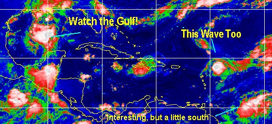
Conditions are changing, and we now have two things to watch closely in the Atlantic. And two more worth keeping an eye on as well.

Firstly, the system predicted to be TD#9 a few days ago is suddenly looking a lot better again this morning. It's just east of the Leeward islands, and hurricane hunters are going out to check on it later today. Folks in the Caribbean still should have been watching it.
Development Chances for this wave today:

(forget it) 0 1 2 3 4 5 6 7 8 9 10 (sure thing)
           [------------*---------]

And that's not all, if you act now--and pull up a satellite image-- you will see a very interesting area in the Central Gulf. This also has hurricane hunter aircraft scheduled to visit it. And is worthy of being watched by everyone in the gulf. Development Chances for this wave:
(forget it) 0 1 2 3 4 5 6 7 8 9 10 (sure thing)
           [-------*--------------]

Beyond that, there's an area Southeast of the Leewards that looks interesting. However, it may be too far south to do much. Also a wave in the east Atlantic is something else to watch in the next few days.

Things are getting busy again.

Atlantic Gets Busy

Comments or Questions? Everyone is invited to use it. Use the comment button by the story Headline.

NRL Monterey Marine Meteorology Division Forecast Track of Active Systems (Good Forecast Track Graphic and Satellite Photos)

StormCarib.com has reports from folks in the Caribbean islands themselves and is worth checking out when storms approach the Caribbean.
Ouragans.com Français -- L'information sur des ouragans comprenant beaucoup de liens.
Tormenta.net Español -- Gran información sobre huracanes aquí.

Crown Weather Services Tropical Update (Includes Map with multiple forecast model tracks)
Snonut's Hurricane Reports

Satellite images at: [N.A. visible] (visible -- Daytime Only) [N.A. infrared] (infrared), and [N.A. water vapor] (water vapor)--Nasa source.

Some Forecast models: (NGM, AVN, MRF, ECMWF, ETA)
DoD weather models (NOGAPS, AVN, MRF)
AVN, ECMWF, GFDL, NOGAPS, UKMET

- [mac]


Show All Comments

Displaying Talkbacks #1 - #5 (of 5 total)

water vapor (#1)
Posted by: GREG
Posted On 11:44AM 08-Sep-2000 with id (RPXNVQNRRWNSP*)


Looks like a nice trough digging well off the east coast ( check water vapor in motion). Is there any reason this would not yank the reborn Leeward system northwest , north and out?

C bros- some thing wrong with the page (#2)
Posted by: Bill Location: TLH
Posted On 11:58AM 08-Sep-2000 with id (RPTNQQPNRQTNYT*)


Hi-

you've got double entries on the captions and the counter has gone bonkers!

IHS,

Bill

activity (#3)
Posted by: Steve H.
Posted On 12:15PM 08-Sep-2000 with id (QSRNRRXNWPNQX*)


Yes the test models for the wave East of the leewards takes it NW. However we still need to watch this area, since as always, it's a timing issue. It's not moving very fast, and may miss the divergent side of the strong upper level high. SHould it do that, it may take a more westward track over time. This system is encountering some shear as a cyclonic circulation to it's NW is hitting it on the north side. It needs to look over it's shoulder as well, since a developing wave to it's SE is moving quickly underneath. This could result in further disruption to it's development. Timing is everything with these systems. But i feel the wave east of the leewards will miss the trough, as it were, and continue on a WNW track. High pressure will establish itself over the northern gulf (it has already) and we'll have to see what effect that will have on it and the system trying to develop in the gulf. It should move that gulf system more to the NNW. I think the current models were keying on a stronger trough over the EAst US this coming week, but that may not happen, and the "trough" that is digging south in the western atlantic should recede north and flatten out. I least that's my take looking at the sat pix right now. Troughs don't normally dig that far south, and the system east of the islands is too far south to be affected at this time. This probably is also contributing to it's slow motion as it waits for the frontal boundary to move to it's NE. Again it's wait and see. Lots of speculation, few answers. CHeers!!

2nd Test Message (#4)
Posted by:
Colleen Location: Lakeland, Florida
Posted On 03:24PM 08-Sep-2000 with id (QURNQVSNQYUNQXY*)


Found this from 1800Z today, this is the 2nd one:


.....THE FOLLOWING IS A TEST MESSAGE.....

NATIONAL HURRICANE CENTER NORTH ATLANTIC OBJECTIVE AIDS FOR

TROPICAL DEPRESSION (AL9200) ON 20000908 1800 UTC


...00 HRS... ...12 HRS... ...24 HRS...

000908 1800 000909 0600 000909 1800


LAT LON LAT LON LAT LON

BAMD 19.8N 59.3W 20.7N 60.6W 21.7N 61.9W

BAMM 19.8N 59.3W 21.0N 60.8W 22.3N 62.2W

A90E 19.8N 59.3W 20.8N 60.0W 21.7N 60.7W

LBAR 19.8N 59.3W 21.0N 60.0W 22.4N 60.8W

SHIP 30KTS 38KTS 46KTS


...36 HRS... ...48 HRS... ...72 HRS...

000910 0600 000910 1800 000911 1800


LAT LON LAT LON LAT LON

BAMD 22.9N 63.1W 24.4N 63.9W 26.9N 63.2W

BAMM 23.8N 63.3W 25.4N 63.9W 28.0N 63.3W

A90E 22.3N 61.5W 22.8N 62.3W 23.0N 63.0W

LBAR 23.9N 61.6W 25.2N 62.0W 26.4N 62.0W

SHIP 54KTS 63KTS 75KTS


...INITIAL CONDITIONS...

LAT0 = 19.8N LON0 = 59.3W DIR0 = 325DEG SPD0 = 6KT

LATM12 = 18.7N LONM12 = 58.7W DIRM12 = 305DEG SPDM12 = 4KT

LATM24 = 18.2N LONM24 = 58.1W

WND0 = 30KT RMAXWD = 40NM WNDM12 = 25KT

CENPRS = 1008MB OUTPRS = 1011MB OUTRAD = 180NM SDEPTH = M

RD34NE = -9NM RD34SE = -9NM RD34SW = -9NM RD34NW = -9NM


.....THE ABOVE HAS BEEN A TEST MESSAGE.....


NNNN


TWC- New Tropical Depression Announced (#5)
Posted by:
Mary Location: Lakeland
Posted On 07:50PM 08-Sep-2000 with id (QRNWWNQVRNXY*)


The OCM at TWC just announced a new T. D. in the Atlantic. Tune in to find out which one where.


Show All Comments


Return to Central Florida Hurricane Center Main Page