| Hermine (2016)  | Hurricanetrack.com Mark Sudduth Storm Surge Cam: Back Bay Brigantine, NJ Hermine (2016)
From http://hurricanetrack.com
See http://hurricanetrack.com/ for more.
| No | Started:
09/05/2016 04:19am
Last Updated:
09/05/2016 10:31am
Last Checked:09/05/2016 05:31pm
Image Count:172 | 1249 |
| Hermine (2016)  | Hurricanetrack.com Mark Sudduth Everywhere Cam, Hermine (2016)
From http://hurricanetrack.com
See http://hurricanetrack.com/flood/ for more.
| No | Started:
09/01/2016 02:37pm
Last Updated:
09/06/2016 12:02am
Last Checked:09/13/2016 07:25am
Image Count:1255 | 1294 |
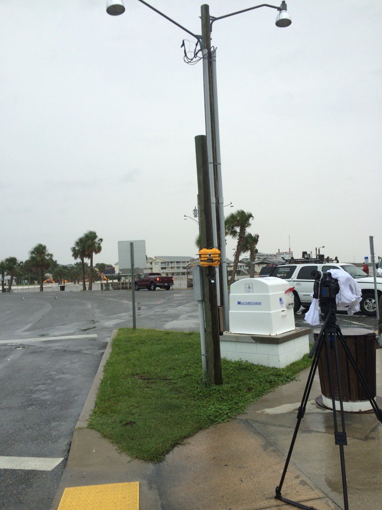
| Hermine (2016)  | Hurricanetrack.com Mark Sudduth Cedar Key Hermine (2016)
From http://hurricanetrack.com
See http://hurricanetrack.com/ for more.
Camera location on map.
Live stream (W/ audio) Link
At 12:51 AM a large piece of decking (With a sign saying Libby's Landing attached to it) from the Seebreeze Restaurant (the big building in the background) got loose and smashed into the camera, that was secured by straps to a wooden pole, this damaged it enough to take offline, the image after is from another camera along the highway.
The yellow box in this photo is where the camera was strapped and chained to:
| No | Started:
09/01/2016 02:31pm
Last Updated:
09/02/2016 07:20am
Last Checked:09/02/2016 04:17pm
Image Count:420 | 1601 |
| Hermine (2016)  | Hurricanetrack.com Mark Sudduth St Marks Cam, Hermine (2016)
From http://hurricanetrack.com
See http://hurricanetrack.com/ for more.
Camera location on map.
Back in Hurricane Dennis of 2005, the storm surge reached to the "3" point in the yellow marker in this image.
Live stream of this image
| No | Started:
09/01/2016 06:35am
Last Updated:
09/02/2016 11:15am
Last Checked:09/02/2016 10:40pm
Image Count:762 | 1781 |
| Hermine (2016)  | Alligator Point, FL Cam recording approach of Hermine (2016)
Webcam is from the Beachview.com Page
This camea is located at the Alligator Point Yacht Basin. In one of the top windows of the Marina Store. The camera faces Northwest with a view of St Teresa and Alligator Bay. Thank Raymond and Ted for keeping the windows clean with all that salt-spray! View cam location on map | No | Started:
08/31/2016 03:44pm
Last Updated:
09/01/2016 08:00am
Last Checked:09/02/2016 09:25am
Image Count:32 | 1394 |
| Hermine (2016)  | St Teresa Beach Cam recording approach of Hermine (2016)
Webcam is from the Beachview.com Page
Located in St. Teresa Florida
| No | Started:
08/31/2016 03:19pm
Last Updated:
09/02/2016 09:25am
Last Checked:09/02/2016 09:25am
Image Count:155 | 1212 |
| Hermine (2016) | Clearwater Beach Webcam recording approach of Hermine (2016)
Webcam is from the Clearwater Beach Rentals
| No | Started:
08/29/2016 05:27pm
Last Updated:
09/01/2016 09:00am
Last Checked:09/02/2016 09:25am
Image Count:254 | 1229 |
| Hermine (2016)  | Long Range Miami/Key West/Tampa Radar Recording of Hermine (2016) Approach
See The Miami Radar Page for more.
This view may switch to Key West or Tampa mid loop if the system moves in range.
For a Full Florida Radar, click here (Not long range)
Frequency of image recording lowered to every 30 minutes while out of range. | No | Started:
08/27/2016 08:46am
Last Updated:
09/04/2016 05:15am
Last Checked:09/04/2016 05:15am
Image Count:949 | 3119 |
| Hermine (2016)  | Florida Radar Recording From SFWMD for Hermine (2016) Florida Approach (Aug 2016)
Images Mirrored From the South Florida Water Management District Website
Purple Line indicates Forecast Track.
Frequency of image recording lowered to every 30 minutes while the center is out of range. | No | Started:
08/27/2016 08:42am
Last Updated:
09/03/2016 07:30am
Last Checked:09/03/2016 07:30am
Image Count:1219 | 2268 |
")
")
")
")
")
")
")
 Approach")
 Florida Approach (Aug 2016)")